Volume 36 Issue 5
Sep.  2019
Turn off MathJax
Article Contents

ZHANG Zhaopeng, LI Zengyuan, TIAN Xin. Precise identification of forest land types based on high resolution remotely sensed imagery[J]. Journal of Zhejiang A&F University, 2019, 36(5): 857-867. doi: 10.11833/j.issn.2095-0756.2019.05.003
Citation: ZHANG Zhaopeng, LI Zengyuan, TIAN Xin. Precise identification of forest land types based on high resolution remotely sensed imagery[J]. Journal of Zhejiang A&F University, 2019, 36(5): 857-867. doi: 10.11833/j.issn.2095-0756.2019.05.003

Precise identification of forest land types based on high resolution remotely sensed imagery

doi: 10.11833/j.issn.2095-0756.2019.05.003
  • Received Date: 2018-10-23
  • Rev Recd Date: 2018-11-23
  • Publish Date: 2019-10-20
  • To compare classification methods of forest land types based on high spatial resolution and remote sensing image data in forested areas, Genhe Ecological Station, Genhe City, Inner Mongolia Autonomous Region was selected and red-edge band satellite data was used. With the RapidEye and GF-1 remote sensing images as the main data source, a comprehensive use of imaged spectral features, textural features, forest resources data, and other auxiliary information, as well as the forest land type field survey sample data in 2016, were compared. The ImageSVM, an Interactive Data Language (IDL) based tool for the support vector machine (SVM) classification, ImageRF, an IDL based tool for the random forest (RF) classification, and traditional classifications, like Maximum Likelihood Classification (MLC) and SVM, were used to precisely classify forest land types. Finally, results of a field survey and forest resources data were used as test samples to verify the classification results with precision verification. Results showed that ImageRF and ImageSVM had high precision for forest type information extraction. With RapidEye image, the overall classification accuracy of eight species types such as coniferous forest, broad-leaved forest and shrubbery were 90.26% and 90.02% respectively with a Kappa coefficient greater than 0.88. At the same time, the protraction accuracy and user precision of shrubbery, coniferous forest, and broadleaf forest in ImageSVM and ImageRF were higher than SVM and MLC. The overall classification accuracy with the ImageSVM method was higher than SVM and MLC classification increased 6.18% and 7.06% respectively, and the Kappa coefficient increased 0.07 with SVM and 0.08 with MLC. The ImageRF method improved 5.93% on SVM and 6.82% on MLC, and the Kappa coefficient increased by 0.07 for SVM and 0.08 for MLC. Also, for fine identification of forest land types, the RapidEye image carrying red-edge band information had better recognition precision and separation ability than Landsat 8 OLI images with no red edge band information. Thus, the ImageSVM and the ImageRF classification methods were effective approaches for precise classification of forest land types, fine identification of forest types, and accurate monitoring of forest resources, especially in mountainous areas with complicated topographic conditions, and could fully meet the needs of forestry applications such as forest resources investigation, forest land change monitoring, and thematic map digital update.
  • [1] GUO Ruixia, LI Chonggui, LIU Sihan, MA Ting, QUAN Qingqing.  Classification of Larix gmelini plantation based on multi-temporal characteristics . Journal of Zhejiang A&F University, 2020, 37(2): 235-242. doi: 10.11833/j.issn.2095-0756.2020.02.006
    [2] ZHANG Yu, CHEN Cunyou, HU Xijun.  Evaluation of forest ecological function based on projection pursuit classification . Journal of Zhejiang A&F University, 2020, 37(2): 243-250. doi: 10.11833/j.issn.2095-0756.2020.02.007
    [3] GUO Wenting, ZHANG Xiaoli.  Vegetation classification based on a multi-feature Sentinel-2 time series . Journal of Zhejiang A&F University, 2019, 36(5): 849-856. doi: 10.11833/j.issn.2095-0756.2019.05.002
    [4] WANG Huaijing, TAN Bingxiang, FANG Xiufeng, LI Shiming, LI Taixing.  Precise classification of forest types use Hyperion image based on the C5.0 decision tree algorithm . Journal of Zhejiang A&F University, 2018, 35(4): 724-734. doi: 10.11833/j.issn.2095-0756.2018.04.018
    [5] YU Bao.  Classification and management technology of trees in overcut forests of Larix gmelinii . Journal of Zhejiang A&F University, 2017, 34(2): 349-354. doi: 10.11833/j.issn.2095-0756.2017.02.020
    [6] HU Man, PENG Daoli.  Comparison of fusion algorithms for GF-2 data from extracted forestland information . Journal of Zhejiang A&F University, 2017, 34(2): 340-348. doi: 10.11833/j.issn.2095-0756.2017.02.019
    [7] ZHOU Keyu, XU Aijun, LI Huixia, XIA Kai.  Design and implementation of the forestry data acquisition system . Journal of Zhejiang A&F University, 2015, 32(4): 491-496. doi: 10.11833/j.issn.2095-0756.2015.04.001
    [8] REN Junjun, FANG Luming, TANG Lihua.  Design and stability of a forestry field information collection system . Journal of Zhejiang A&F University, 2013, 30(2): 234-239. doi: 10.11833/j.issn.2095-0756.2013.02.012
    [9] WANG Ni, PENG Shi-kui, LI Ming-shi.  High-resolution remote sensing of textural images for tree species classification . Journal of Zhejiang A&F University, 2012, 29(2): 210-217. doi: 10.11833/j.issn.2095-0756.2012.02.010
    [10] SUN Meng-jun, XU Jun.  Division of high conservation value forest based on forest management of county level . Journal of Zhejiang A&F University, 2011, 28(6): 878-883. doi: 10.11833/j.issn.2095-0756.2011.06.007
    [11] HU Yun, FANG Lu-ming.  A method of avoiding crack for compressing polygon data by topological data conversion . Journal of Zhejiang A&F University, 2011, 28(4): 597-600. doi: 10.11833/j.issn.2095-0756.2011.04.012
    [12] LI Yi-ping, XU Ai-jun, YANG Shao-qin.  Research on key technologies of GIS-based low hilly woodland management system . Journal of Zhejiang A&F University, 2009, 26(4): 554-560.
    [13] ZHANG Guang-qun, WANG Bao-ping, WANG Hang-jun.  MapX-based processing of spatial data inconsistent problems . Journal of Zhejiang A&F University, 2009, 26(4): 587-591.
    [14] ZHANG Mao-zhen, TANG Xiao-ming, XIE Yang-sheng, DING Li-xia.  Analysis of query efficiency of forest resources database system . Journal of Zhejiang A&F University, 2009, 26(2): 149-154.
    [15] ZENG -wei, LI Guang-hui, HU Hai-gen, TANG Jian-feng.  Design and implementation of personal digital assistant (PDA) based information collection system for forest resources . Journal of Zhejiang A&F University, 2009, 26(1): 111-115.
    [16] LUO Xian-xian, KANG Xin-gang.  Progress in research on the comprehensive monitoring of forest resources . Journal of Zhejiang A&F University, 2008, 25(6): 803-809.
    [17] ZHANG Mao-zhen, TANG Xiao-ming, WANG Ya-xin, ZHANG Huai-qing, WU Dong-liang.  Oracle DBMS based forest resources spatial database storage . Journal of Zhejiang A&F University, 2008, 25(4): 411-416.
    [18] BAI Jiang-li, PENG Dao-li, YANG Fu-ning.  Information classification and code of forest resources . Journal of Zhejiang A&F University, 2007, 24(3): 326-330.
    [19] WU Da-sheng, HUANG Mei-li, CHEN Fei.  Integration of distributed data of timber transportation licence . Journal of Zhejiang A&F University, 2006, 23(4): 435-438.
    [20] GUAN Feng-ying, FENG Zhong-ke, WANG Xiao-kun, ZHOU Bin.  Simulation experiment of surveying forest land area with RTD GPS . Journal of Zhejiang A&F University, 2004, 21(2): 150-153.
  • [1]
    LI Zengyuan, CHEN Erxue, GAO Zhihai, et al. Current development status and proposals for national forest remote sensing techniques and applications[J]. Bull Chin Acad Sci, 2013, 28(suppl 1):132-144.
    [2]
    LI Deren, TONG Qingxi, LI Rongxing, et al. Current issues in high-resolution Earth observation technology[J]. Sci China Earth Sci, 2012, 55(7):1043-1051.
    [3]
    TIAN Xin, YAN Min, van der TOL C, et al. Modeling forest above-ground biomass dynamics using multi-source data and incorporated models:a case study over the Qilian mountains[J]. Agric For Meteorol, 2017, 246:1-14.
    [4]
    JIN Wenji, LIU Zhengkai. A mixed classification method for multicategory remotely-sensed image recognition[J]. Remote Sensing Environ China, 1995, 10(4):298-302.
    [5]
    CHEN Xu, XU Zuorong, YU Shixiao. Multi-level forest classification of QuickBird remote sensing image based on objects[J]. Remote Sensing Technol Appl, 2009, 24(1):22-26.
    [6]
    HARKEN J, SUGUMARAN R. Classification of Iowa wetlands using an airborne hyperspectral image:a comparison of the spectral angle mapper classifier and an object oriented approach[J]. Can J Remote Sensing, 2005, 31(2):167-174.
    [7]
    ZHANG Shufen, XING Yanqiu, Aihemaitijiang Abuduaini, et al. Comparison on forest type classification methods based on TM images[J]. For Eng, 2014, 30(1):18-21.
    [8]
    EITEL J U H, VIERLING L A, LITVAK M E, et al. Broadband, red-edge information from satellites improves early stress detection in a New Mexico conifer woodland[J]. Remote Sensing Environ, 2011, 115(12):3640-3646.
    [9]
    QIU Chengjin. Feature Extraction of Typical Vegetation Based on RapidEye Images[D]. Beijing: China University of Mining and Technology, 2014.
    [10]
    YAN Min, LI Zengyuan, CHEN Erxue, et al. Vegetation fractional coverage change in Daxinganling Genhe forest reserve of Inner Mongolia[J]. Chin J Ecol, 2016, 35(2):508-515.
    [11]
    ZHANG Zhaopeng, LI Zengyuan, LI Qihu, et al. Dynamic analysis on the vegetation coverage changes of Minqin Oasis based on GF-1 remote sensing image from 2013 to 2015[J]. J Southwest For Univ, 2017, 37(2):163-170.
    [12]
    REN Chong, JU Hongbo, ZHANG Huaiqing, et al. Multi-source data for forest land type precise classification[J]. Sci Silv Sin, 2016, 52(6):54-65.
    [13]
    van der LINDEN S, RABE A, HELD M, et al. The EnMAP-Box:a toolbox and application programming interface for EnMAP data processing[J]. Remote Sensing, 2015, 7(9):11249. doi:10.3390/rs70911249.
    [14]
    LIN Haiyan, YUE Cairong, WU Xiaohui, et al. Remote sensing image classification by EnMAP-Box model[J]. J Southwest For Univ, 2014, 34(2):67-71.
    [15]
    PLATT J C. Probabilistic outputs for support vector machines and comparisons to regularized likelihood methods[J]. Adv Large Margin Classif, 2000, 10(4):61-74.
    [16]
    CHANG Chihchung, LIN Chihjen. LIBSVM:a library for support vector machines[J]. ACM Transac Intell Syst Technol, 2011, 2(3):1-27.
    [17]
    WANG Xingling, LI Zhanbin. Identifying the parameters of the kernel function in support vector machines based on the grid-search method[J]. Period Ocean Univ China, 2005, 35(5):859-862.
    [18]
    WANG Jianfeng, ZHANG Lei, CHEN Guoxing, et al. A parameter optimization method for an SVM based on improved grid search algorithm[J]. Appl Sci Technol, 2012, 39(3):28-31.
    [19]
    SVETNTIK K, LIAW A, TONG C, et al. Random forest:a classification and regression tool for compound classification and QSAR modeling[J]. J Chem Inf Comput Sci, 2003, 43(6):1947-1958.
    [20]
    WASKE B, van der LINDEN S, OLDENBURG C, et al. ImageRF:a user-oriented implementation for remote sensing image analysis with random forests[J]. Environ Model Software, 2012, 35:192-193.
    [21]
    YEH C H. Classification and regression trees (CART)[J]. Chemometrics Intell Libr Sys, 1991, 12(2):95-96.
    [22]
    QUINLAN J R. Induction of decision trees[J]. Mach Learn, 1986, 1(1):81-106.
    [23]
    ZHANG Junqian, WANG Wenjin. The research of remote sensing image fine classification base on cross validation[J]. Urban Geotech Investig Survey, 2016(2):88-92, 96.
    [24]
    BARLIN J N, ZHOU Qin, CLAIR C M S, et al. Classification and regression tree (CART) analysis of endometrial carcinoma:seeing the forest for the trees[J]. Gynecol Oncol, 2013, 130(3):452-456.
  • 加载中
通讯作者: 陈斌, bchen63@163.com
  • 1. 

    沈阳化工大学材料科学与工程学院 沈阳 110142

  1. 本站搜索
  2. 百度学术搜索
  3. 万方数据库搜索
  4. CNKI搜索

Figures(7)  / Tables(5)

Article views(4487) PDF downloads(220) Cited by()

Related
Proportional views

Precise identification of forest land types based on high resolution remotely sensed imagery

doi: 10.11833/j.issn.2095-0756.2019.05.003

Abstract: To compare classification methods of forest land types based on high spatial resolution and remote sensing image data in forested areas, Genhe Ecological Station, Genhe City, Inner Mongolia Autonomous Region was selected and red-edge band satellite data was used. With the RapidEye and GF-1 remote sensing images as the main data source, a comprehensive use of imaged spectral features, textural features, forest resources data, and other auxiliary information, as well as the forest land type field survey sample data in 2016, were compared. The ImageSVM, an Interactive Data Language (IDL) based tool for the support vector machine (SVM) classification, ImageRF, an IDL based tool for the random forest (RF) classification, and traditional classifications, like Maximum Likelihood Classification (MLC) and SVM, were used to precisely classify forest land types. Finally, results of a field survey and forest resources data were used as test samples to verify the classification results with precision verification. Results showed that ImageRF and ImageSVM had high precision for forest type information extraction. With RapidEye image, the overall classification accuracy of eight species types such as coniferous forest, broad-leaved forest and shrubbery were 90.26% and 90.02% respectively with a Kappa coefficient greater than 0.88. At the same time, the protraction accuracy and user precision of shrubbery, coniferous forest, and broadleaf forest in ImageSVM and ImageRF were higher than SVM and MLC. The overall classification accuracy with the ImageSVM method was higher than SVM and MLC classification increased 6.18% and 7.06% respectively, and the Kappa coefficient increased 0.07 with SVM and 0.08 with MLC. The ImageRF method improved 5.93% on SVM and 6.82% on MLC, and the Kappa coefficient increased by 0.07 for SVM and 0.08 for MLC. Also, for fine identification of forest land types, the RapidEye image carrying red-edge band information had better recognition precision and separation ability than Landsat 8 OLI images with no red edge band information. Thus, the ImageSVM and the ImageRF classification methods were effective approaches for precise classification of forest land types, fine identification of forest types, and accurate monitoring of forest resources, especially in mountainous areas with complicated topographic conditions, and could fully meet the needs of forestry applications such as forest resources investigation, forest land change monitoring, and thematic map digital update.

ZHANG Zhaopeng, LI Zengyuan, TIAN Xin. Precise identification of forest land types based on high resolution remotely sensed imagery[J]. Journal of Zhejiang A&F University, 2019, 36(5): 857-867. doi: 10.11833/j.issn.2095-0756.2019.05.003
Citation: ZHANG Zhaopeng, LI Zengyuan, TIAN Xin. Precise identification of forest land types based on high resolution remotely sensed imagery[J]. Journal of Zhejiang A&F University, 2019, 36(5): 857-867. doi: 10.11833/j.issn.2095-0756.2019.05.003
  • 林业是生态建设的主体,履行着建设和保护“三个系统、一个多样性”(森林、湿地和荒漠生态系统及生物多样性)的重要职能[1-2]。为了对林地资源进行科学管理和有效利用,寻找经济、高效、精确的林地资源信息获取方法是林业工作的重点。航天遥感技术的快速发展,为国家林地资源信息获取提供了有效手段。从不同来源、不同形式的遥感信息中准确快速、高质高效地获取林地类型精细信息,实现森林资源的定期,甚至实时监测,为清查森林资源、预测预报森林火灾、利用和保护森林资源提供了重要基础和依据[3]。目前,国内外学者利用不同遥感数据,在林地类型提取方面通过不同的研究方法进行了大量的研究,以提高林地类型的分类精度[4-7]。随着第1颗提供“红边”波段的商业卫星——RapidEye卫星的发射,其独特的光谱特征被国际各类遥感卫星研究及应用机构认可与采用。国内外学者通过将具有红边波段的RapidEye遥感卫星数据应用于森林胁迫时空监测、农业和植物分类等方面发现,红边信息在一定程度上可提高监测精度和分类精度[8-9]。中国自行研制的GF-6是一颗只携带一部相机实现超大宽幅(800 km)的高分辨率卫星,且新增的红边、黄边谱段对于大区域的森林、农作物等植被生长状况监测、植被类型识别具有独特的优势。利用红边波段对林地类型精细分类尚未见报道,因此本研究以内蒙古自治区根河市根河森林生态站为例,以携带红边波段且有一定数据获取量的RapidEye数据为主要数据源,采用基于EnMAP-Box的随机森林和支持向量机的分析方法展开研究,通过寻优参数选择和分类器训练等方面的优化设计,将RapidEye数据所携带的红边信息应用于林地类型分类,从独特的波段信息运用和运行速率出发,开展具有较高实际应用价值的林地类型精细识别方法。同时以GF-1数据为对比研究数据,探讨携带红边波段信息的卫星数据对林地类型精细分类的影响,为国产GF-6卫星在林业资源调查方面的深入应用提前探路,为高分辨率成果全面服务于中国林业发展和生态环境建设提供一定的技术参考。

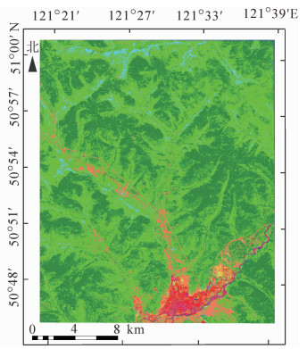
  • 根河市是内蒙古自治区呼伦贝尔市北部的县级市,地处大兴安岭北段。地理坐标为50°20′~52°30′N,120°12′~122°55′E,是中国纬度最高的城市之一,更是中国平均气温最低的旗市。根河市资源以森林资源为主体,森林覆盖率为91.7%,森林面积达174.5万hm2[10],樟子松Pinus sylvestris var. mongholica,兴安落叶松Larix spp.和白桦Betula platyphylla等是该区的主要树种。本研究核心区域为包含内蒙古首个森林生态观测站——“大兴安岭森林气候生态观测站”在内的矩形区域(51°00′~51°45′N,121°23′~121°43′E),位于根河市南部。

  • 国产GF-1数据由中国资源卫星应用中心提供[11],RapidEye数据由高分辨率对地观测系统重大专项(民用部分)科研项目(21-Y20A06-9001-17/18)提供。数据详细信息见表 1

    数据 多光谱分辨率/m 全色分辨率/m 实验数据 波谱范围/mm
    获取时间 数据级别 绿 红边 近红外 全色
    RapidEye 5 2016-7-14 Level 1B 0.440~0.510 0.520~0.590 0.630~0.685 0.690~0.730 0.760~0.850
    GF-1PMS 8 2 2017-7-4 Level 1A 0.450~0.520 0.520~0.590 0.630~0.690 0.770~0.890 0.450~0.900

    Table 1.  The datailed information of satellite data

  • 其他数据包括:①样地调查数据。2016年8月1-30日,在根河市境内进行实测,获得3种类型样地:Q样地(19个)、复测样地(27个)和航线样地(71个),其中航线样地包括13个方形样地(30 m ×30 m)和58个圆形样地(直径30 m);②辅助数据。大兴安岭根河生态站小班数据和二调森林资源分布图作为辅助数据,Landsat8 OLI数据作为基准影像数据,来源于美国地质勘探局(USGS)官网(http://landsat.usgs.gov/);③数字高程模型数据。根河市30 m分辨率的GDEMV2数据,来源于地理空间数据云;④矢量数据。生态站矢量数据和研究区矢量数据作为影像裁剪数据。⑤检验样本。结合外业调查数据和Google影像,在研究区共选取74个分布均匀的样地(外业采集方形样本大小:30 m × 30 m,自选方形样本大小:20 m × 20 m)作为验证样本,其中:阔叶林和针叶林各18个、灌木林12个、耕地、水体和建筑用地各6个、草地5个、裸地3个。

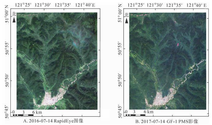
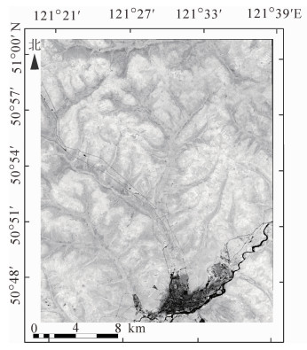
  • 图像预处理包括辐射定标、大气校正、正射校正、图像融合、地形校正和图像配准等。其中:①大气校正采用FLAASH大气校正;②图像融合。GF-1数据采用融合效果较好的NNDiffuse Pan sharpening法进行图像融合,RapidEye数据不进行此处理;③地形校正。采用广泛应用的C校正模型进行地形校正;④图像配准。以经过辐射定标、大气校正和正射校正的Landsat 8 OLI遥感影像(2017年7月)为基准影像,以GF-1和RapidEye遥感影像分别为待校正影像,通过图像自动配准后的方法进行图像配准处理,配准后GF-1和RapidEye遥感影像的总的均方根误差(RMSE)分别达0.58个像元和0.56个像元,均满足图像配准要求,最终的数据预处理结果如图 1所示。

    Figure 1.  The results of data preprocessing

  • 根据国家林业局颁发的《国家森林资源连续清查技术规定(2014)》[12]、研究区的地表覆盖情况和应用需求,本研究将主要地物类型划分为针叶林、阔叶林、灌木林、草地、建筑用地、裸地、水体和耕地8类。

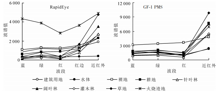
  • 基于Rapid Eye和GF-1 PMS影像上8种地物类型的光谱特征(图 2),分析各类别在不同数据源、不同时相影像上的光谱差异和光谱域类别可分性。由图 2可知:RapidEye影像上红边波段(red edge,RE)处是植被光谱响应的转折点,差异性明显;GF-1 PMS影像上,针叶林、阔叶林、灌木林、草地和耕地在近红外波段(near infrared,NIR)表现出明显的植被光谱响应峰值。

    Figure 2.  Spectral curves of eight typical ground objects for RapidEye and GF-1 PMS images

  • 红边波段是介于红光波段和近红外波段之间的波段。植被叶片反射率在红边谱段范围会发生突变,是植物曲线最为明显的特征,是研究的重点光谱区域。红边与植被的各种理化参数紧密相关,可以更好地应用于林业和农业等方面进行植被类型精细识别。归一化红边指数(normalized difference red edge vegetation index,NDRE)是归一化植被指数(NDVI)的改进型,它对叶冠层的微小变化、林窗片断和衰老非常敏感,可用于精准农业、森林监测和植被胁迫性探测等。计算公式为:

    式(1)中:INDRE表示归一化红边指数;ρNIRρRE分别表示近红外波段(NIR)和红边波段(RE)的反射率。通常,-1<INDRE<1,且当0.2≤INDRE≤0.9时,表示为绿色植被区。

  • EnMAP-Box是由德国环境制图与分析计划项目组基于交互式数据语言(interactive data language,IDL)开发的一款对高光谱遥感数据处理与分析的工具包[13-14]

    ImageSVM是柏林洪堡大学地理实验室开发的一种利用IDL语言对遥感影像进行支持向量机(support vector machine classification, SVM)分类和回归分析的非商业产品工具[15]。支持向量机法是基于统计学理论,以结构风险最小化为基础,通过最小化经验风险和置信区间,将神经网络结构选择问题转化为较容易的核函数选择问题,对于样本数量较少的研究,具有很好的优势[16]。SVM通过引入核函数,将非线性问题转化为线性问题,有效减小算法复杂度,避免经典学习中过学习和维数灾难等弊端[17],而且具有很好的通用性、鲁棒性。本研究选用的核函数是目前广泛应用的径向基函数。SVM的参数优化功能是基于网格搜索算法,通过网格搜索法在可控范围内寻得适合模型的最优的核函数参数g与惩罚系数C是SVM分类的关键[18-20]。EnMAP网格搜索寻优时,核函数g的范围为:0.010 0~1 000.000 0,惩罚系数C的默认值为0.1,乘数(multiplie,M)的范围为1<M≤10。一般情况下,设置g的最小值为0.01,最大值为10;C的最小值为1,最大值为1 000,其对应的乘数Mg和乘数Mc均为1.2~2.0。

  • ImageRF是一种基于IDL程序的遥感影像分类方法。随机森林(random forests, RF)是利用bootstrap重抽样方法从原始样本中抽取多个样本,对每个bootstrap样本进行决策树建模,然后将这些决策树组合起来,通过投票得出最终的预测或者分类结果[20-21]。随机森林进行分类时预选变量个数m和随机森林中树的个数n是进行参数调优的关键。在ImageRF分类时选用的RFC(Random Forests Classification)模型是一种利用训练样本和内部验证的参考数据集进行参数优化的分类模型[23-24]。EnMAP中随机森林分类主要通过改变树的数量(number of trees)来提高分类精度,其默认值为100,在大多数情况下。该默认值已可以达到很高的分类精度。

  • 利用NDRE独有的特性,将其参与支持向量机分类。首先,在波段计算器中对RapidEye影像数据通过公式(1)进行波段运算,得到RapidEye数据的归一化红边指数图像(单波段)。然后将所得到的单波段归一化红边指数数据和RapidEye遥感数据的5个(蓝、绿、红、红边和近红外)波段通过ENVI提供的“Layer Stacking”工具进行波段组合,最后将加入归一化红边波段信息的RapidEye影像进行SVM分类处理。

  • 经过外业调查与遥感影像对应,针对在本研究区确定的8种不同的目标地物类型,利用影像上地物的特征(形状、大小、色调及纹理结构等),来确定本研究区的训练样本。利用ENVI 5.4.1软件中Compute ROI Separability工具计算任意2个类别间的差异性程度,即以任意类别间的统计距离来衡量训练样本的可分离性。结果表明:选择的8种类型样本间的可分离性较好,其中参数值大于1.90(合格样本)的占25/28,在1.86~1.90的占3/28。

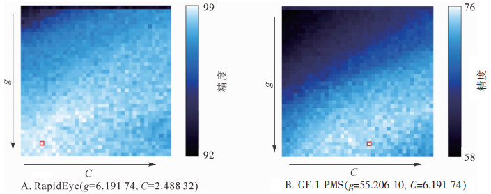
  • 利用SVM模型中的网格搜索法,寻得的RapidEye和GF-1遥感影像的最优参数(gC)如图 3所示。图 3右边柱状部分为图例,表示最低精度和最高精度的值。观察分析图 3可知:g值较小和C值较高时,精度值较高。

    Figure 3.  Optimum parameter result

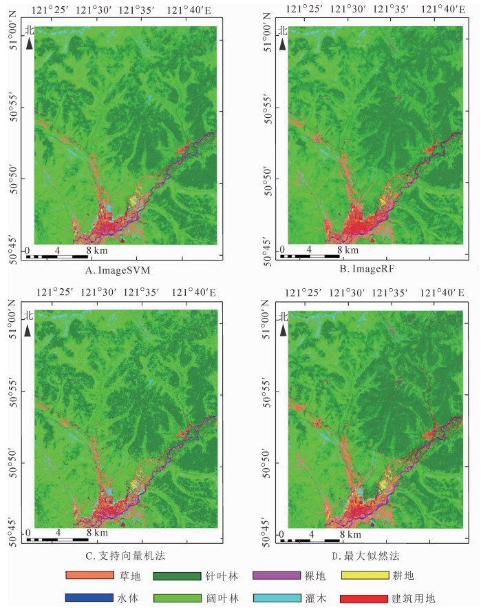
  • 为了对比分析研究方法的分类效果,用传统的最大似然法(MLC)和SVM法的分类结果为对比。最优参数参与下的ImageSVM法分类和ImageRF法,以及MLC和SVM法的分类结果分别如图 4RapidEye)和图 5GF-1)所示。图中A和B分别为ImageSVM法和ImageRF法的影像分类结果;图 4图 5中C和D分别为传统SVM和MLC法的分类结果。通过式(1)对Rapideye遥感影像进行波段计算,获得单波段的归一化植被指数图像,如图 6所示。将其与5波段的RapidEye遥感影像通过波段重组(layer stacking),重新生成一个6波段的遥感影像,然后通过SVM分类法对重组后的遥感影像进行分类,得到NDRE参与下的SVM分类结果(图 7)。

    Figure 4.  Classification results for RapidEye image

    Figure 5.  Classification results for GF-1 image

    Figure 6.  NDRE(Single-band)

    Figure 7.  Classification result for SVM with NDRE

  • 利用外业调查数据和选取的检验样本,通过建立混淆矩阵对RapidEye和GF-1遥感影像不同分类方法的分类结果进行精度验证,精度验证结果分别见表 2表 3所示。

    RapidEye影像 ImageSVM ImageRF 支持向量机 最大似然法
    制图精度/% 用户精度/% 制图精度/% 用户精度/% 制图精度/% 用户精度/% 制图精度/% 用户精度/%
    建筑用地 94.75 72.52 92.27 74.89 75.41 66.59 85.91 74.58
    针叶林 88.74. 91.21 89.82 90.19 83.45 88.49 75.17 88.22
    水体 95.88 99.43 97.53 99.44 95.05 98.58 91.76 97.09
    耕地 96.43 98.54 96.43 94.41 63.57 80.91 92.86 77.84
    灌木 91.79 95.57 93.92 92.51 94.22 84.47 85.11 72.73
    草地 98.12 98.82 98.59 99.06 92.02 96.55 91.74 93.90
    阔叶林 90.66 88.32 88.70 88.21 85.50 80.87 83.26 79.71
    裸地 54.50 86.47 50.71 84.25 59.24 66.14 60.66 75.29
    总体分类精度/% 90.261 7 90.018 3 84.084 0 83.201 5
    Kappa系数 0.884 6 0.881 7 0.811 5 0.801 8

    Table 2.  Classification accuracy table for RapidEye image

    GF-1影像 ImageSVM ImageRF 支持向量机 最大似然法
    制图精度/% 用户精度/% 制图精度/% 用户精度/% 制图精度1% 用户精度/% 制图精度1% 用户精度/%
    建筑用地 85.73 68.21 83.64 67.20 49.29 73.85 53.68 72.34
    针叶林 97.23 84.86 97.03 84.25 93.21 66.49 93.54 69.07
    水体 96.24 87.98 96.24 84.95 94.23 73.82 93.02 72.79
    耕地 81.06 94.16 80.70 94.93 93.90 94.15 98.65 91.74
    灌木 99.79 90.23 99.68 90.05 93.64 65.43 93.54 71.50
    草地 97.82 97.88 98.14 98.07 72.70 90.06 77.79 90.33
    阔叶林 88.26 97.40 91.07 97.95 77.55 92.30 76.11 94.82
    裸地 70.13 97.25 70.71 98.86 81.91 88.41 91.37 90.10
    总体分类精度/% 90.183 1 90.733 9 81.152 6 82.962 6
    Kappa系数 0.880 1 0.888 9 0.775 7 0.797 8

    Table 3.  Classification accuracy table for GF-1 image

    通过表 2表 3可知:对于RapidEye和GF-1遥感影像,基于EnMAP-Box的随机森林和支持向量机分类的总体分类精度和Kappa系数均高于传统的SVM和MLC分类。其中:高分辨率的RapidEye和GF-1PMS遥感影像效果更明显,ImageRF和ImageSVM的总体分类精度相对于传统的SVM和MLC均提高了6%以上。

    上述分析可知:ImageSVM和ImageRF法在复杂山区林地类型精细识别中精度和可信度高。针对这2种具有同等分类效果的方法,在运行效率和广泛适用性方面进行对比研究,结果如表 4所示。

    数据来源 图像分辨率
    (图像大小)/m
    ImageSVM运行效率 ImageRF运行效率
    SVM模型构建/min 分类运行/h RFC模型构建/min 分类运行/h
    GF-1 PMS 2 >240 >24 3.5 3
    RapidEye 5 30 5 0.5 1.5
    Landsat OLI 15 15 3 0.25 0.5
    说明:运行环境为台式计算机(型号:Think Centre; 处理器:In-tel (R) Core (TM) i7-3770CPU@ 3.40GHz; 内存(RAM)8.00GB; 操作系统:64位操作系统, 基于×64的处理器)

    Table 4.  Comparative study on data operation efficiency under the same operating environment of the same range

    表 4可知:在相同条件(影像类型相同、数据范围相同、运行环境相同),ImageRF分类法相对于ImageSVM分类法,精度基本一致,但其费时少、效率快,是一种快速高效的分类方法。针对大区域林地类型精细识别而言,ImageSVM对运行环境的要求极高,花费时间也较长,广泛适用性较差。同样,对RapidEye遥感影像基于NDRE参与下的SVM分类结果进行精度验证。结果如表 5所示。

    RapidEye 建筑用地 针叶林 水体 耕地 灌木林 草地 阔叶林 裸地 合计
    建筑用地 328 0 4 48 0 0 0 28 408
    针叶林 0 788 2 0 10 0 18 0 818
    水体 9 0 240 0 0 0 0 0 249
    耕地 5 0 0 78 0 15 0 0 98
    灌木 4 0 0 0 406 0 7 0 417
    草地 3 0 4 0 0 460 8 0 475
    阔叶林 3 28 0 0 22 2 660 0 715
    裸地 59 0 0 0 0 0 0 120 179
    合计 411 816 250 126 438 477 693 148 3 359
    制图精度/% 79.81 96.57 96.00 61.90 92.69 96.44 95.24 81.08
    用户精度/% 80.39 96.39 96.44 79.59 97.36 96.84 92.31 67.04
    总体分类精度=(3 080/3 359)=91.694 0%,Kappa系数=0.891 9

    Table 5.  Accuracy verification confusion matrix statistics for SVM classification with NDRE/Pixel

    表 5表 2可知:归一化红边指数NDRE参与下的支持向量机分类与传统的支持向量机分类结果的分类精度由84.08%增长到91.69%,提高了7.61%。由此可知,红边波段信息对林地具有很好的区分性,可极大地提高林地类型的精细识别精度。

  • 本研究面向国家森林资源监测调查的行业重大需求,对复杂地形条件下高分辨率遥感影像林地类型精细识别方面展开了深入的研究与分析。主要结论如下:①本研究EnMap-Box支持下的ImageSVM和ImageRF分类方法相对于传统的SVM和MLC分类方法具有较高的分类精度,是一种有效的林地类型信息精细识别方法,具有精度高和可信度高的优势,可满足森林资源调查、变化监测、数字更新等林业应用需求。对于2016年的RapidEye影像,ImageSVM相对于SVM和MLC分类方法其总体分类精度分别提高了6.18%和7.06%,Kappa系数分别提高了0.07和0.08;ImageRF分别提高了5.93%和6.82%,Kappa系数分别提高了0.07和0.08,均能确保森林资源调查成果的精细化、准确性、高效性;尤其是具有红边波段的RapidEye遥感影像在林地类型精细识别方面的显著优势,将在林地类型精准监测、时空变化信息提取以及森林空间结构分析等方面发挥重要作用,为国产GF-6卫星数据在林地类型精细识别和精准监测研究打下坚实的基础。②相对于无红边波段的GF-1遥感数据,携带红边波段的RapidEye数据对林地类型具有较高的识别精度和可分性。其中,ImageSVM法对各类影像的总体分类精度为90.26%(RapidEye)>90.18%(GF-1);ImageRF法为90.73%(GF-1)>90.02%(RapidEye);SVM法为84.08%(RapidEye)>81.15%(GF-1);MLC法为90.26%(RapidEye)>90.18%(GF-1)。相同方法,不同数据情况下,RapidEye数据的总体分类精度均最优。③以RapidEye遥感影像为数据源,通过对比传统支持向量机分类和归一化红边指数参与下的支持向量机分类精度验证结果可知:分类精度提高了7.61%。红边波段信息对林地具有很好的区分性,可极大提高林地类型的精细识别精度。同时,对比基于样本的面向对象分类法和传统SVM和MLC分类法的分类精度可知:该方法的分类精度均高于2种传统的分类方法,满足林地类型精细分类要求,但是其自动化程度低、费时费力、受人为因素影响较大,不适合大区域林地类型精细识别研究。

    本研究取得了一定的研究成果,同时也存在诸多的问题与不足:①林地类型的精细识别依赖于影像对象特征具有高度的可分性,但仅依靠影像对象颜色、纹理、几何等低层次特征,还不足以对光谱特征极其相似的不同林地类型进行精细识别。对携带红边波段信息的遥感数据,充分应用归一化红边指数、信息熵、波段均值等特征对林地类型进行精细识别。②根河市生态站具有典型性和代表性,以落叶松为主的针叶纯林、以白桦和杨树为主的落叶阔叶林以及天然灌木林具有明显的时空特征。落叶阔叶林、灌木林及其他林地未进一步细分,且该区域火烧迹地经过多年自然恢复均已变为灌木林,故未精细分出。本研究所采用的方法在其他区域的林地类型精细识别能力及实用性在其他林区还需要进一步的验证与评估。

Reference (24)

Catalog

    /

    DownLoad:  Full-Size Img  PowerPoint
    Return
    Return