Turn off MathJax
Article Contents

YANG Jingyi, LI Zhenyan, Du Weixin, et al. Spatiotemporal evolution and driving factors of ecological environmental quality in Yulin, Shaanxi Province[J]. Journal of Zhejiang A&F University, 2026, 43(4): 1−12 doi:  10.11833/j.issn.2095-0756.20250479
Citation: YANG Jingyi, LI Zhenyan, Du Weixin, et al. Spatiotemporal evolution and driving factors of ecological environmental quality in Yulin, Shaanxi Province[J]. Journal of Zhejiang A&F University, 2026, 43(4): 1−12 doi:  10.11833/j.issn.2095-0756.20250479

OnlineFirst articles are published online before they appear in a regular issue of the journal. Please find and download the full texts via CNKI.

Spatiotemporal evolution and driving factors of ecological environmental quality in Yulin, Shaanxi Province

DOI: 10.11833/j.issn.2095-0756.20250479
  • Received Date: 2025-09-02
  • Accepted Date: 2026-04-21
  • Rev Recd Date: 2026-04-09
  •   Objective  A systematic study of the spatiotemporal evolution and driving mechanisms of ecological environmental quality in Yulin City, Shaanxi Province is of great importance. It has significant theoretical value and practical significance for maintaining ecological security of the Loess Plateau.   Method  6 periods of Landsat remote sensing imagery (2000, 2005, 2010, 2015, 2020, and 2025) of Yulin City were selected to construct the integrated remote sensing ecological index (IIRSE). Theil-Sen slope estimation, Mann-Kendall test, and Hurst exponent method were employed to systematically analyze the spatial distribution and temporal evolution trends of ecological and environmental quality in Yulin City over the past 25 years. Furthermore, a parameter-optimized geographical detector model was used to quantitatively assess the explanatory power of different driving factors and their interactive effects on ecological quality.   Result  (1) From 2000 to 2025, the ecological environmental quality in Yulin City decreased from southeast to northwest. The mean IIRSE increased by 0.124, with an average annual growth rate of 1.34%. Areas of good ecological quality increased from 6.4% to 17.72%, while regions of poor and relatively poor quality significantly shrank, falling to 16.76% and 30.44%, respectively. (2) Changes in ecological quality were mainly low-frequency, while areas with frequent changes were concentrated in Jia, Wubu, and Suide County. Spatial autocorrelation analysis showed that the area of high-high clustering expanded year by year, indicating a continuous optimization of the ecological spatial pattern. (3) The ecological environment in Yulin City had generally improved, but regional differences were significant. Hurst index indicated that only 48.44% of the area had the potential for continued improvement, while about 23.31% faced the risk of ecological degradation. Changes in IIRSE were mainly driven by natural factors, with precipitation and elevation as key influences. Land use changes and human activities also played important roles in affecting ecological quality.   Conclusion  From 2000 to 2025, the ecological environmental quality in Yulin City showed an overall improving trend, with a spatial pattern of high values in the southeast and low values in the northwest. Areas of good quality expanded, while low-quality areas shrank, indicating an optimization of ecological pattern. However, spatial differentiation remains, and a certain proportion of the region still faces the risk of degradation. The driving mechanisms are mainly dominated by natural factors, with additional influence from human activities. To consolidate ecological gains, Yulin City should focus on systematic restoration in high-risk degradation areas and promote ecological protection together with comprehensive management. [Ch, 8 fig. 42 ref.]
  • [1] ZHANG Jianguo, WANG Haoyi, PAN Yuxuan.  Driving mechanism of health benefit perception among recreational users in suburban forest parks . Journal of Zhejiang A&F University, doi: 10.11833/j.issn.2095-0756.20240589
    [2] LI Ting, LI Chaokui, CONG Zheng, FENG Yuanyuan, MAO Yan.  Construction and optimization of ecological network pattern in Daye mining area based on remote sensing ecological index . Journal of Zhejiang A&F University, doi: 10.11833/j.issn.2095-0756.20240484
    [3] LI Siyuan, YE Zhenni, MAO Yongwei, CHEN Yuling, ZENG Na.  Comparison of four fusion models for generating high spatio-temporal resolution NDVI . Journal of Zhejiang A&F University, doi: 10.11833/j.issn.2095-0756.20220381
    [4] DENG Zhuo, LI Wenjing, ZHANG Yufang, DONG Ye.  Spatio-temporal evolution of ecological security pattern and its influencing factors in Tianshan-Pamir region . Journal of Zhejiang A&F University, doi: 10.11833/j.issn.2095-0756.20220458
    [5] PAN Ting, WANG Yixiang, LIU Xianzhao, XU Chengli, LIU Zhijun.  Land use change and its impact on ecological quality in Xiong’an New Area . Journal of Zhejiang A&F University, doi: 10.11833/j.issn.2095-0756.20220596
    [6] ZHANG Shiwen, LI Chengrong, WANG Yan, WU Yang.  Evaluation and evolution characteristics of ecological quality in Yunnan based on long-time series satellite remote sensing . Journal of Zhejiang A&F University, doi: 10.11833/j.issn.2095-0756.20220439
    [7] ZHU Jindi, WEI Xinliang, TANG Mengping, YANG Jingjing, ZHANG Jiyan.  Construction of diversity index of tree species composition . Journal of Zhejiang A&F University, doi: 10.11833/j.issn.2095-0756.20210171
    [8] ZHOU Yang, ZHOU Wenbin, MA Jiawei, RUAN Zhongqiang, YE Zhengqian, LIU Dan.  Soil environmental quality investigation and ecological risk assessment of a reclamation land in Jinyun County . Journal of Zhejiang A&F University, doi: 10.11833/j.issn.2095-0756.20210289
    [9] HUANG Xiaofen, BAI Ou.  Spatial distribution characteristics and influencing factors of forest villages in Zhejiang Province . Journal of Zhejiang A&F University, doi: 10.11833/j.issn.2095-0756.20210558
    [10] ZHOU Siyi, YIN Xiaojie, TANG Ruiquan, WU Pengfei.  Evaluation of eco-environmental quality in typical rocky desertification areas in the upper reaches of the Yangtze River . Journal of Zhejiang A&F University, doi: 10.11833/j.issn.2095-0756.20210523
    [11] CUI Yanglin, DONG Bin, WEI Huimin, XU Wenrui, YANG Fei, PENG Liang, FANG Lei, WANG Yuting.  Granularity effect of landscape index at the county scale . Journal of Zhejiang A&F University, doi: 10.11833/j.issn.2095-0756.20190477
    [12] JIN Jiale, SUN Jian, YANG Libin, DONG Chengfeng, QI Feng.  Correlation between the remote sensing index of the underlying surface and the surface temperature in the villages in Hangzhou . Journal of Zhejiang A&F University, doi: 10.11833/j.issn.2095-0756.20190379
    [13] LI Chao, PEI Shunxiang, ZHANG Lianjin, GUO Jia, XIN Xuebing.  Applicability evaluation of competition indexes for Pinus tabuliformis plantations in Beijing . Journal of Zhejiang A&F University, doi: 10.11833/j.issn.2095-0756.2019.06.008
    [14] ZHAO Xungang, HU Yucun, WANG Wenhui, HU Yunqing.  Changes in the ecological environment of Wuhai City and driving factors . Journal of Zhejiang A&F University, doi: 10.11833/j.issn.2095-0756.2019.05.019
    [15] WANG Wantong, WANG Jinxia, FU Qiang.  Ecological capital in the Central Plains Urban Agglomeration (CPUA) region of China based on remote sensing technology . Journal of Zhejiang A&F University, doi: 10.11833/j.issn.2095-0756.2018.06.020
    [16] ZHANG Yanru, LIANG Lizhuang, NIU Shukui, HAN Hairong.  Ecological landscape quality of Taiyue Mountain in Shanxi . Journal of Zhejiang A&F University, doi: 10.11833/j.issn.2095-0756.2016.04.007
    [17] GU Jianqiang, ZHANG Wen, ZHU Fan, CHEN Feng, SU Guangyun, QI Hengnian.  WQI for water quality evaluation in Qingshan Lake . Journal of Zhejiang A&F University, doi: 10.11833/j.issn.2095-0756.2016.05.023
    [18] ZHU Quan.  Tourism development strategy in Qingyuan County under the brand of “the Chinese county with the best eco-environment” . Journal of Zhejiang A&F University, doi: 10.11833/j.issn.2095-0756.2012.03.018
    [19] JIANG Shuang-lin, JIANG Qun-hua.  Preliminary study of the legal safeguard for agro-ecological environment in China . Journal of Zhejiang A&F University,
    [20] WU Wei-guang, WANG Chuan-chang.  Advance of research in forest environmental value evaluation . Journal of Zhejiang A&F University,
  • [1]
    FENG Dongmei, XIA Jun, ZHANG Bulin, et al. Spatial-temporal evolution and zoning management of ecological environment quality in Northeast China based on MRSEI from a multi-scale perspective[J/OL]. Environmental Science, 2025-07-11. https://doi.org/10.13227/j.hjkx.202504177.
    [2]
    ZHOU Siyi, YIN Xiaojie, TANG Ruiquan, et al. Evaluation of eco-environmental quality in typical rocky desertification areas in the upper reaches of the Yangtze River[J]. Journal of Zhejiang A&F University, 2022, 39(4): 783−791. DOI: 10.11833/j.issn.2095-0756.20210523.
    [3]
    XU Hanqiu. A remote sensing urban ecological index and its application[J]. Acta Ecologica Sinica, 2013, 33(24): 7853−7862. DOI: 10.5846/stxb201208301223.
    [4]
    XU Hanqiu. Assessment of ecological change in soil loss area using remote sensing technology[J]. Transactions of the Chinese Society of Agricultural Engineering, 2013, 29(7): 91−97, 294. DOI: 10.3969/j.issn.1002-6819.2013.07.012.
    [5]
    Kawuqiati Baishan, WANG Xuemei, HUANG Xiaoyu. Analysis of temporal and spatial evolution of ecological environment quality in Hotan City[J]. Southwest China Journal of Agricultural Sciences, 2022, 35(2): 453−462. DOI: 10.16213/j.cnki.scjas.2022.2.028.
    [6]
    WANG Lixia, ZHAO Rui, LIU Zhao, et al. Monitoring and prediction of ecological environmental quality in the Yanhe River Basin based on the remote sensing ecological index[J]. Arid Zone Research, 2022, 39(3): 943−954. DOI: 10.13866/j.azr.2022.03.28.
    [7]
    HU Yingying, LUO Hongxia, DAI Shengpei, et al. Evaluation of ecological environment quality and analysis of driving mechanism in Wuzhishan City of Hainan Island based on remote sensing ecological indices[J]. Ecology and Environmental Sciences, 2024, 33(10): 1624−1633. DOI: 10.16258/j.cnki.1674-5906.2024.10.014.
    [8]
    RAN Hongling, XIANG Nan, LÜ Chunyan, et al. Dynamic assessment and prediction of ecological environment quality in Tongren based on RSEI and CA-Markov−taking Tongren, Guizhou Province as an example[J]. Environmental Protection Science, 2025, 51(3): 158−167. DOI: 10.16803/j.cnki.issn.1004-6216.202405012.
    [9]
    YANG Huimin, ZHANG Yufei, WANG Decai. Evaluation and analysis of ecological environment quality in Jiaozuo City based on remote sensing ecological index[J]. Journal of Henan Agricultural University, 2025, 59(4): 686−697. DOI: 10.16445/j.cnki.1000-2340.20241018.001.
    [10]
    WANG Fang, ZHU Xin, HE Xingyu, et al. Spatial and temporal evolution and impact factors analysis of ecological environmental quality in Luoshan Nature Reserve over the past 30 years[J/OL]. Journal of Ningxia University (Natural Science Edition), 2024-11-19. https://doi.org/10.20176/j.cnki.nxdz.000059.
    [11]
    HASAN M M, FERDOUS M T, TALHA M, et al. Analyzing ecological environmental quality trends in Dhaka through remote sensing based ecological index (RSEI)[J]. Land, 2025, 14(6): 1258. DOI: 10.3390/land14061258.
    [12]
    FU Kaixiang, JIA Guodong, YU Xinxiao, et al. Evaluation of ecological environment quality and analysis of driving mechanism in Tulufan-Hami region based on improved remote sensing ecological indices[J]. Acta Ecologica Sinica, 2024, 44(9): 3911−3923. DOI: 10.20103/j.stxb.202308091712.
    [13]
    ZHAO Jiali, LI Xing, SUN Bing. Spatial-temporal evolution and driving factors analysis of ecological environment quality in Daihai Basin based on AWRSEI[J]. Environmental Science, 2024, 45(3): 1598−1614. DOI: 10.13227/j.hjkx.202305059.
    [14]
    ZHANG Haobin, WANG Wan, SONG Yujing, et al. Ecological index evaluation of arid inflow area based on the modified remote sensing ecological index: a case study of Tabu River Basin at the northern foot of the Yin Mountains[J]. Acta Ecologica Sinica, 2024, 44(2): 523−543. DOI: 10.20103/j.stxb.202210132910.
    [15]
    CHEN Fuguo, GUO Aiqing, WU Aibin, et al. Evolution of urban expansion pattern and its impact on the quality of the ecological environment in the Beijing-Tianjin-Hebei urban agglomeration[J]. Environmental Science, 2025, 46(6): 3708−3719. DOI: 10.13227/j.hjkx.202409036.
    [16]
    ZHAO Xiaoyan, TAN Shucheng, ZHANG Su, et al. Analysis of spatial and temporal changes and driving forces of ecological environment quality in Tuojiang River Basin based on RSEI improved modeling[J]. Journal of Soil and Water Conservation, 2024, 38(5): 151−163. DOI: 10.13870/j.cnki.stbcxb.2024.05.017.
    [17]
    DENG Zhuo, LI Wenjing, ZHANG Yufang, et al. Spatio-temporal evolution of ecological security pattern and its influencing factors in Tianshan-Pamir region[J]. Journal of Zhejiang A&F University, 2023, 40(2): 398−406. DOI: 10.11833/j.issn.2095-0756.20220458.
    [18]
    FEI Bingqiang, WU Bo, YIN Jie, et al. Changes in the spatial pattern of newly cultivated and abandoned farmland in the Mu Us Sandy Land from 1964 to 2020 and their impact on desertification[J]. Arid Land Geography, 2025, 48(4): 661−672. DOI: 10.12118/j.issn.1000-6060.2024.390.
    [19]
    ZHANG Yisong, CAO Guoliang, ZHANG Meng. Comparative research on the sustainable development of northern Shaanxi based on the principal component analysis[J]. Environmental Engineering, 2017, 35(5): 136−140. DOI: 10.13205/j.hjgc.201705029.
    [20]
    FENG Li, ZHANG Pengfei, ZHANG Maosheng, et al. Strategies and practical paths for ecological restoration and comprehensive management in Yulin coal mining area in the new era[J]. Northwestern Geology, 2023, 56(3): 19−29. DOI: 10.12401/j.nwg.2023087.
    [21]
    WANG Hengheng, WANG Jiarong, HOU Jiaye, et al. Spatiotemporal variations and driving factors of ecological environment quality in the Northwest China based on SA-RSEI model[J]. Chinese Journal of Ecology, 2025, 44(11): 3852−3863. DOI: 10.13292/j.1000-4890.202511.021.
    [22]
    DU Zeyu, JI Xibin, LIU J, et al. Ecological health assessment of Tibetan alpine grasslands in Gannan using remote sensed ecological indicators[J]. Geo-spatial Information Science, 2025, 28(1): 246−264. DOI: 10.1080/10095020.2024.2311862.
    [23]
    ZHANG Siyuan, FAN Yifei, YAN Li, et al. Temporal and spatial variation and driving forces of eco-environmental quality in Shaanxi Province in recent 20 years based on long time series MODIS data[J]. Journal of Soil and Water Conservation, 2023, 37(2): 111−119, 198. DOI: 10.13870/j.cnki.stbcxb.2023.02.014.
    [24]
    GAO Rong, YAO Wei, SHI Changchun, et al. Evaluation of sandification and desertification dynamics in the windy and sandy area of Yulin over the past 20 years[J]. Shaanxi Forest Science and Technology, 2022, 50(5): 73−80. DOI: 10.3969/j.issn.1001-2117.2022.05.016.
    [25]
    BAIG M H A, ZHANG Lifu, SHUAI Tong, et al. Derivation of a tasselled cap transformation based on Landsat 8 at-satellite reflectance[J]. Remote Sensing Letters, 2014, 5(5): 423−431. DOI: 10.1080/2150704X.2014.915434.
    [26]
    CHANDER G, MARKHAM B L, HELDER D L. Summary of current radiometric calibration coefficients for Landsat MSS, TM, ETM+, and EO-1 ALI sensors[J]. Remote Sensing of Environment, 2009, 113(5): 893−903. DOI: 10.1016/j.rse.2009.01.007.
    [27]
    DUAN Sibo, RU Chen, LI Zhaoliang, et al. Reviews of methods for land surface temperature retrieval from Landsat thermal infrared data[J]. National Remote Sensing Bulletin, 2021, 25(8): 1591−1617. DOI: 10.11834/jrs.20211296.
    [28]
    YU Xiaolei, GUO Xulin, WU Zhaocong. Land surface temperature retrieval from Landsat 8 TIRS−comparison between radiative transfer equation-based method, split window algorithm and single channel method[J]. Remote Sensing, 2014, 6(10): 9829−9852. DOI: 10.3390/rs6109829.
    [29]
    WANG Shiwei, MA Chao, MA Yingying, et al. Monitoring and evaluation of ecological restoration in open-pit coal mine using remote sensing data based on a OM-RSEI model[J]. International Journal of Mining Reclamation and Environment, 2025, 39(8): 600−622. DOI: 10.1080/17480930.2025.2458012.
    [30]
    LIU Bo, HUO Runbin, LI Liyang, et al. Monitoring the spatio-temporal dynamics of desertification in Huade County, Inner Mongolia based on Albedo-NDVI feature space[J]. Geology in China, 2025, 52(4): 1439−1453. DOI: 10.12029/gc20240606002.
    [31]
    LI Ting, LI Chaokui, CONG Zheng, et al. Construction and optimization of ecological network pattern in Daye mining area based on remote sensing ecological index[J]. Journal of Zhejiang A&F University, 2025, 42(3): 601−610. DOI: 10.11833/j.issn.2095-0756.20240484.
    [32]
    YANG Hua, XU Yong, WANG Lijia, et al. Spatio-temporal variation of human activity intensity and its driving factors on the Qinghai-Tibet Plateau[J]. Acta Ecologica Sinica, 2023, 43(10): 3995−4009. DOI: 10.5846/stxb202211183332.
    [33]
    CHEN Hongjin, LIU Lin, ZHANG Zhengyong, et al. Spatiotemporal correlation between human activity intensity and surface temperature on the north slope of Tianshan Mountains[J]. Acta Geographica Sinica, 2022, 77(5): 1244−1259. DOI: 10.11821/dlxb202205014.
    [34]
    XU Dong, YANG Feng, YU Le, et al. Quantization of the coupling mechanism between eco-environmental quality and urbanization from multisource remote sensing data[J]. Journal of Cleaner Production, 2021, 321: 128948. DOI: 10.1016/j.jclepro.2021.128948.
    [35]
    CHEN Zhiyong, WU Yaowei, LIN Gangte, et al. Spatial relationship between eco-environment quality and land use change in Guangdong Province-Hong Kong-Macao, China based on remote sensing-based ecological index[J]. Environmental Science, 2024, 45(11): 6433−6447. DOI: 10.13227/j.hjkx.202310211.
    [36]
    KANG Ligang, XIN Cunlin, YANG Yufan, et al. Remote sensing evaluation of ecological environment quality in Gansu Province and quantitative identification of its driving factors[J]. Environmental Science, 2025, 46(6): 3730−3746. DOI: 10.13227/j.hjkx.202406186.
    [37]
    HELILI P, ZAN Mei. Coupling coordination development of urbanization and ecological environment in the urban agglomeration on the northern slope of the Tianshan Mountains, China[J]. Sustainability, 2023, 15(5): 4099. DOI: 10.3390/su15054099.
    [38]
    YANG Jingyi, LI Zhenyan, YIN Fang, et al. Spatio-temporal correlation between human activity intensity and remote sensing ecological index in the Guanzhong Plain urban agglomeration[J]. Environmental Science, 2025, 46(12): 7935−7946. DOI: 10.13227/j.hjkx.202411094.
    [39]
    WANG Jingyu, YANG Liping, WANG Mei, et al. Spatio-temporal monitoring and driving factor analysis of eco-environment quality in the Loess Plateau of northern Shaanxi[J]. Environmental Science, 2025, 46(7): 4522−4533. DOI: 10.13227/j.hjkx.202406111.
    [40]
    YANG Liangjie, ZHANG Lingling, ZHANG Fangning, et al. A study on the resilience of ecological networks in the Loess Plateau from the perspective of ecological security patterns[J]. Acta Ecologica Sinica, 2024, 44(22): 10471−10485. DOI: 10.20103/j.stxb.202402240388.
    [41]
    CAO Fei, ZHOU Jing, XIN Yurun, et al. Analysis of vegetation variation and driving mechanism in Mu Us Sandy Land under the background of oasization[J]. Acta Ecologica Sinica, 2025, 45(9): 4431−4445. DOI: 10.20103/j.stxb.202405061007.
    [42]
    CHEN Yingbiao, ZHENG Zihao, WU Zhifeng, et al. Review and prospect of application of nighttime light remote sensing data[J]. Progress in Geography, 2019, 38(2): 205−223. DOI: 10.18306/dlkxjz.2019.02.005.
  • 加载中
通讯作者: 陈斌, bchen63@163.com
  • 1. 

    沈阳化工大学材料科学与工程学院 沈阳 110142

  1. 本站搜索
  2. 百度学术搜索
  3. 万方数据库搜索
  4. CNKI搜索

Figures(8)

Article views(13) PDF downloads(0) Cited by()

Related
Proportional views

Spatiotemporal evolution and driving factors of ecological environmental quality in Yulin, Shaanxi Province

doi: 10.11833/j.issn.2095-0756.20250479

Abstract:   Objective  A systematic study of the spatiotemporal evolution and driving mechanisms of ecological environmental quality in Yulin City, Shaanxi Province is of great importance. It has significant theoretical value and practical significance for maintaining ecological security of the Loess Plateau.   Method  6 periods of Landsat remote sensing imagery (2000, 2005, 2010, 2015, 2020, and 2025) of Yulin City were selected to construct the integrated remote sensing ecological index (IIRSE). Theil-Sen slope estimation, Mann-Kendall test, and Hurst exponent method were employed to systematically analyze the spatial distribution and temporal evolution trends of ecological and environmental quality in Yulin City over the past 25 years. Furthermore, a parameter-optimized geographical detector model was used to quantitatively assess the explanatory power of different driving factors and their interactive effects on ecological quality.   Result  (1) From 2000 to 2025, the ecological environmental quality in Yulin City decreased from southeast to northwest. The mean IIRSE increased by 0.124, with an average annual growth rate of 1.34%. Areas of good ecological quality increased from 6.4% to 17.72%, while regions of poor and relatively poor quality significantly shrank, falling to 16.76% and 30.44%, respectively. (2) Changes in ecological quality were mainly low-frequency, while areas with frequent changes were concentrated in Jia, Wubu, and Suide County. Spatial autocorrelation analysis showed that the area of high-high clustering expanded year by year, indicating a continuous optimization of the ecological spatial pattern. (3) The ecological environment in Yulin City had generally improved, but regional differences were significant. Hurst index indicated that only 48.44% of the area had the potential for continued improvement, while about 23.31% faced the risk of ecological degradation. Changes in IIRSE were mainly driven by natural factors, with precipitation and elevation as key influences. Land use changes and human activities also played important roles in affecting ecological quality.   Conclusion  From 2000 to 2025, the ecological environmental quality in Yulin City showed an overall improving trend, with a spatial pattern of high values in the southeast and low values in the northwest. Areas of good quality expanded, while low-quality areas shrank, indicating an optimization of ecological pattern. However, spatial differentiation remains, and a certain proportion of the region still faces the risk of degradation. The driving mechanisms are mainly dominated by natural factors, with additional influence from human activities. To consolidate ecological gains, Yulin City should focus on systematic restoration in high-risk degradation areas and promote ecological protection together with comprehensive management. [Ch, 8 fig. 42 ref.]

YANG Jingyi, LI Zhenyan, Du Weixin, et al. Spatiotemporal evolution and driving factors of ecological environmental quality in Yulin, Shaanxi Province[J]. Journal of Zhejiang A&F University, 2026, 43(4): 1−12 doi:  10.11833/j.issn.2095-0756.20250479
Citation: YANG Jingyi, LI Zhenyan, Du Weixin, et al. Spatiotemporal evolution and driving factors of ecological environmental quality in Yulin, Shaanxi Province[J]. Journal of Zhejiang A&F University, 2026, 43(4): 1−12 doi:  10.11833/j.issn.2095-0756.20250479
  • 生态环境质量是衡量区域生态系统健康状况与可持续发展能力的重要综合指标,其演变过程不仅能反映自然系统的动态响应,还体现出人类活动对环境的综合影响[1]。在全球气候变化与人类活动不断加剧的背景下,生态系统退化、土地荒漠化、水土流失等生态问题日益突出,严重威胁区域生态安全与社会经济的协调发展。尤其在生态环境脆弱区,精准掌握生态质量的时空演变规律及其驱动机制,对生态治理成效评估、空间格局优化与生态文明建设具有重要意义[2]

    随着遥感技术在生态环境质量监测中的应用不断深化,基于遥感的生态环境质量评价逐渐从单因子指标(如归一化植被指数、地表温度、湿度、归一化差异裸土指数),向多因子综合模型转变[3]。遥感生态指数可融合多个生态因子、提取主成分并自动加权,已被广泛用于城市与区域生态监测研究[49]。为克服遥感生态指数(IRSE)在不同区域适应性不足、指标代表性有限等问题,多种改进型模型被提出,如引入熵权法的改进型遥感生态指数[10],结合生物丰度[1112]、净初级生产力[13]、大气污染(如PM2.5)、沙漠化指数(ID)、盐渍化指数(IS)等多源数据的综合遥感生态指数(IIRSE)[1415],以提高评价的科学性与适应性。除生态质量本身的监测外,生态演变的成因解析也逐步受到关注。地理探测器模型作为揭示空间分异性及其驱动因子的统计方法,被广泛应用于生态学、地理学等领域[16]。通过识别影响因子的解释力与交互作用,该模型可深入揭示生态系统变化背后的自然与人文驱动机制。尤其是参数优化的地理探测器(OPGD),在提升空间分层敏感性和模型解释力方面表现出良好性能[1012]

    黄土高原作为中国生态系统最脆弱的区域之一,长期以来受严重的水土流失和土地退化影响,生态建设任务十分艰巨[1]。榆林市地处黄土高原与毛乌素沙地过渡带,是黄河流域生态保护的重要节点,近年来,榆林市在防沙治沙、植被恢复、水土保持等方面取得成效,生态格局和生态功能不断优化,成为西北地区生态治理的重要示范区[1719]。目前,尽管已有研究关注榆林市生态环境质量变化[2021],但多采用MODIS (500 m分辨率)数据,在干旱半干旱背景下,对土地沙化严重的典型区域尚缺乏精细尺度的系统分析[22]。且目前生态环境质量评价模型在榆林市的应用效果有限,这与榆林市沙漠化与盐渍化问题突出有关。针对类似区域的研究通常单独引入IDIS,但可能导致评价结果存在一定的局限性。因此,本研究基于IRSE融入IDIS,旨在构建适用于榆林地区干旱、土地退化等典型生态问题的生态环境质量评价模型,实现对区域生态环境质量的综合动态评估。

    本研究以陕西省榆林市为研究对象,选取2000、2005、2010、2015、2020和2025年6期Landsat遥感数据,在Google Earth Engine (GEE)平台上基于IRSE,引入IDIS,构建多因子融合的IIRSE,结合Theil-Sen和Mann-Kendall非参数趋势检验与Hurst指数分析方法,揭示榆林市生态环境质量的时空演变趋势与未来演化的持续性特征,并采用OPGD探讨相关因素对生态环境质量的影响,以期为区域生态环境保护提供理论支撑。

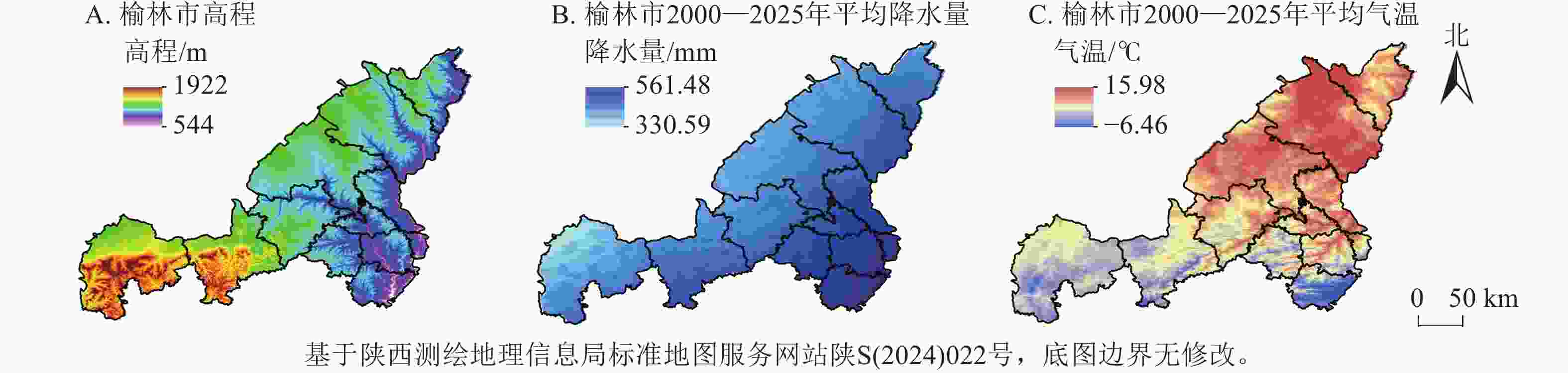
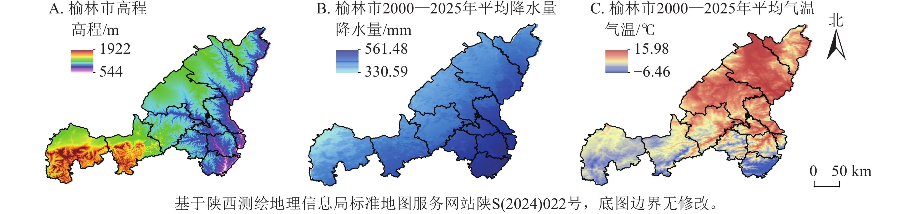
    • 榆林市位于陕西省北部,地处毛乌素沙地与黄土高原交界处,是黄河“几字弯”中心区域和黄河流域生态保护的重要节点城市[23]。经过70余年治理,已实现从“沙进人退”到“绿进沙退”的转变[24]。全市总面积为4.29万km2,辖2区10县,地貌以风沙草滩区、黄土丘陵沟壑区为主,地势西高东低,属半干旱大陆性季风气候,年均温度为8 ℃,年均降水量为400 mm,夏季集中(图1)。

      Figure 1.  Overview of study area

    • 夏季生长季影像可有效捕捉植被旺盛生长时期的生态信息,从而保证生态指标提取的可靠性[7, 15],故本研究选取了2000、2005、2010、2015、2020和2025年6—8月的Landsat影像数据(Landsat 5 TM及Landsat 8 OLI/TIRS)。对影像数据进行辐射定标、大气校正及云遮掩处理,以确保不同时期影像的可比性和一致性。基于多光谱波段计算与提取关键生态因子,构建IIRSE,为后续的生态环境质量动态监测与时空演变分析提供数据支撑。

      为探究榆林市生态环境质量的主要驱动因素,选取了包括自然与人为因素在内的多类驱动因子。自然因子主要包括年降水量、高程、坡度与气温;人为因子则涵盖人类活动强度、土地利用类型及夜间灯光数据等。考虑到榆林市位于毛乌素沙地边缘这一特殊地理背景,将PM2.5作为重要驱动因子纳入分析框架,以更全面评估其生态影响[15, 23]。降水数据来源于国家气象科学数据中心,高程数据来源于地理空间数据云,土地利用数据来源于中国科学院资源环境科学与数据中心,夜间灯光数据为NPP/VIIRS (2012—2023年),来源于美国国家海洋和大气管理局国家地球物理数据中心,气温数据来源于国家地球系统科学数据中心。人口密度数据从WorldPop数据库获取。对所有数据进行投影转换,统一采用WGS_1984_UTM_Zone_49N坐标系,并重采样至30 m分辨率,以保证数据的空间匹配性。其中,因数据获取年份受限,故选择2023年夜间灯光数据、土地利用数据及2024年降水量、气温代替2025年参与驱动因素分析计算。

    • IRSE通常基于绿度、湿度、热度、干度这4个重要指标构建[2529],为全面反映陕西省榆林市干旱-半干旱区的生态环境质量特征,在传统IRSE框架基础上引入区域敏感性指标,构建IIRSE。由于榆林市植被覆盖度低、土壤水分亏缺以及土地退化问题突出,选取绿度指数(IGDV)代替归一化植被指数反映植被生长状况与覆盖水平,采用湿度指数(W)表征地表水分状况,同时引入ID刻画荒漠化过程,IS揭示干旱区土壤盐渍化风险[21]IGDVISID的计算参考文献[21, 2930]。

      为确保各指标在主成分分析中的权重平衡,需对4个核心生态环境指标进行归一化处理,将其数值统计至[0, 1],以实现量纲一致性[29]。基于PCA提取的第一主成分(PC1)作为初始综合生态指数(IIRSE0),计算公式如下:

      随后,将IIRSE0进行归一化处理,使其最终值域稳定在[0, 1],得到IIRSE,计算公式如下:

      PC1的载荷分析中,若对生态环境质量具有正向指示意义的IGDVWPC1中的载荷为负,而IDIS等退化因子载荷为正,需对PC1进行反向处理,以确保IIRSE与生态环境质量水平保持正相关关系[31]

    • 构建IHA表征人类活动强度,计算过程如下:

      式(3)~(5)中,IHA为人类活动强度指数,LNTDPSHAIL为归一化处理后的土地利用数据、人口密度数据和陆地表层人类活动强度数据,SCLE为建设用地当量面积,S为区域总面积,Li为第i种土地类型面积,Ci为第i种土地类型建设用地折算系数,n为土地类型数量。参考文献[3233],abc取值分别为0.3、0.3、0.4,建设用地、耕地、草地的折算系数分别为1、0.4、0.067,其余类型设为0。

    • Theil-Sen趋势分析是一种非参数检验方法,可有效处理数据中小规模离群点和缺失值噪声,通过估算时间序列中每对点数的斜率,取其中位数;Mann-Kendall显著性检验算法的测量值既不受缺失值和异常值干扰,也无需满足正态分布,在区域生态环境质量评价中能有效检验总体趋势的显著性[2930, 3435]。对2000—2025年榆林市生态环境质量进行时间序列分析,将变化趋势分为明显退化、轻微退化、稳定不变、轻微改善、明显改善5个等级[36]

    • 采用重标极差(R/S)分析方法计算IIRSE的Hurst指数(H),预测IIRSE的变化趋势[36],0.5<H<1,表明未来变化趋势与过去一致,且H越接近1,变化持续性越强;0<H<0.5,意味着未来变化趋势与过去相反,且H越接近0,反持续性越明显;H=0.5,表示变化趋势不显著,变化呈随机性。

    • 该方法适用于揭示地理现象空间分异特征及其驱动机制,主要包含因子探测、交互探测、生态探测及风险探测4个模型[17]。本研究重点采用因子探测识别IIRSE变化的主导因子,并通过交互探测分析两因子联合作用对IIRSE变化的解释力[3135]。榆林市被划分为500 m×500 m的172 152个网格,利用ArcGIS提取各因子至样本点,并以不同年份的IIRSE作为因变量,采用OPGD模型量化各指标对生态环境的影响力水平及交互作用特征。

    • 利用GeoDa软件对IIRSE进行空间自相关分析。通过计算全局莫兰指数来衡量区域整体生态环境质量的空间自相关性,判断其在空间分布上的集聚或离散特征;进一步采用局部莫兰指数来度量局部空间依赖程度,揭示潜在的空间集聚模式,并识别不同区域生态质量的空间分布差异。计算公式参考文献[2930]。

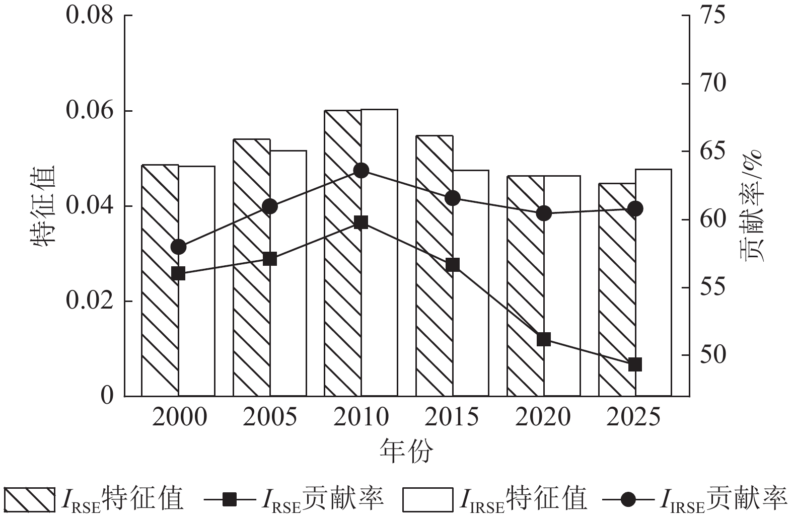
    • 图2所示:在第一主成分贡献率方面,IIRSE的贡献率为57.97%~63.60%,平均贡献率为60.88%,贡献率方差为2.75%,表明其贡献率相对稳定。IRSE的贡献率为49.31%~59.77%,平均贡献率为 54.67%,贡献率方差为13.11%,整体低于IIRSE且波动幅度明显更大。量化对比显示:IIRSE平均贡献率比IRSE高6.21%,说明IIRSE第一主成分贡献率优于IRSE。第一主成分载荷能够揭示各指标对生态质量的贡献方向,对生态有积极作用的绿度和湿度指标在2种模型中均表现为正值,而荒漠化和盐渍化指标均为负值,符合生态质量评价的理论预期。这表明IIRSE在生态环境质量综合评价中的应用具有合理性与优势。
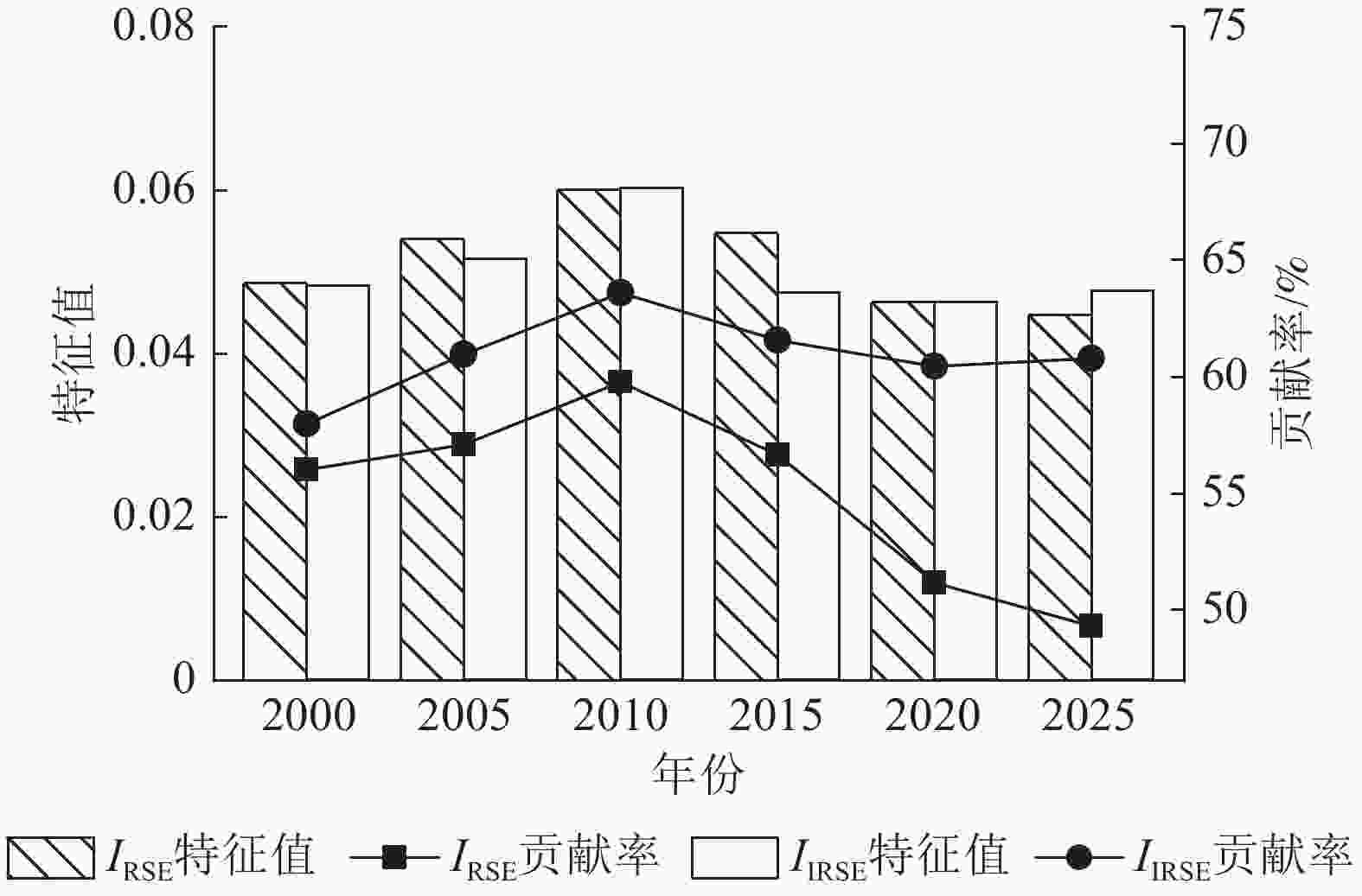
      Figure 2.  Comparison between IIRSE and IRSE

      2000、2005、2010、2015、2020、2025年IIRSE均值分别为0.313、0.351、0.414、0.344、0.378、0.437,整体呈波动上升趋势。可见,榆林市生态环境质量在此期间持续改善,表现出良好的生态恢复态势。

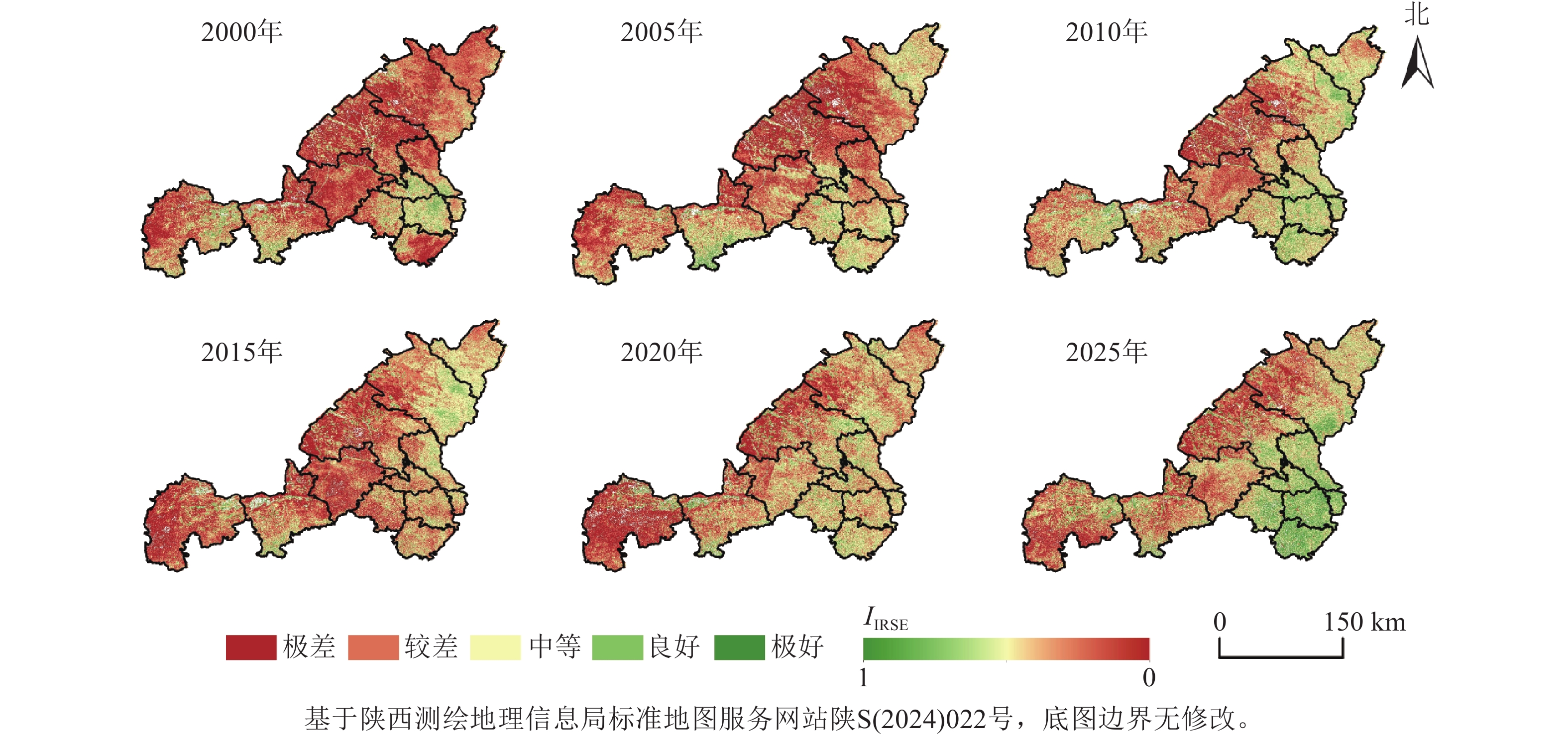
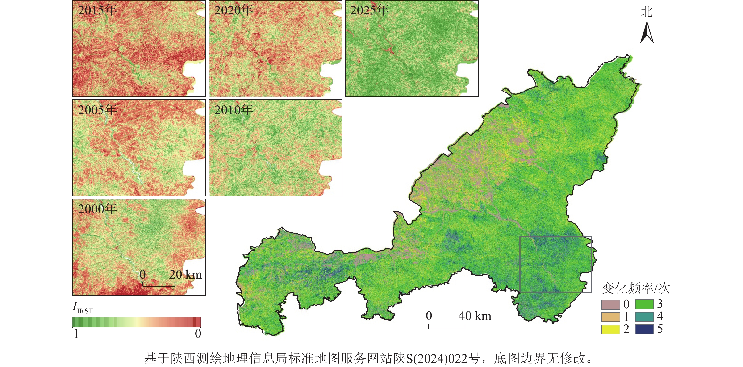
    • 参考文献[37]中基于IRSE的生态等级划分标准,将IIRSE划分为5个等级:极差(0~0.2)、较差(0.2~0.4)、中等(0.4~0.6)、良好(0.6~0.8)、极好(0.8~1)。由图3所示:榆林市生态环境质量在时间维度上稳步提升,在空间分布上则表现出由东南向西北递减的梯度格局。2000—2025年,IIRSE年均增长率为1.34%。其中,生态质量良好区域面积占比从6.40%增加至17.72%;极差区域占比从30.65%下降至16.76%;较差区域占比由42.18%减少至30.44%。受自然与人为因素共同作用,榆林市IIRSE及其变化在空间上表现出较大分异。空间上,IIRSE呈西北低、东南高的梯度分布格局,环境质量良好和极好以上区域占比达25.07%,主要分布于佳县、吴堡、米脂、绥德、子洲与清涧等县;极差区域主要分布在榆林市西部,毛乌素沙地东南缘,生态基础较弱,尽管治理效果逐步显现,但受限于干旱、降水少等自然条件,仍属低质量区域。整体上,榆林市生态环境质量向好趋势明显,治理成效优良,生态系统逐步恢复。
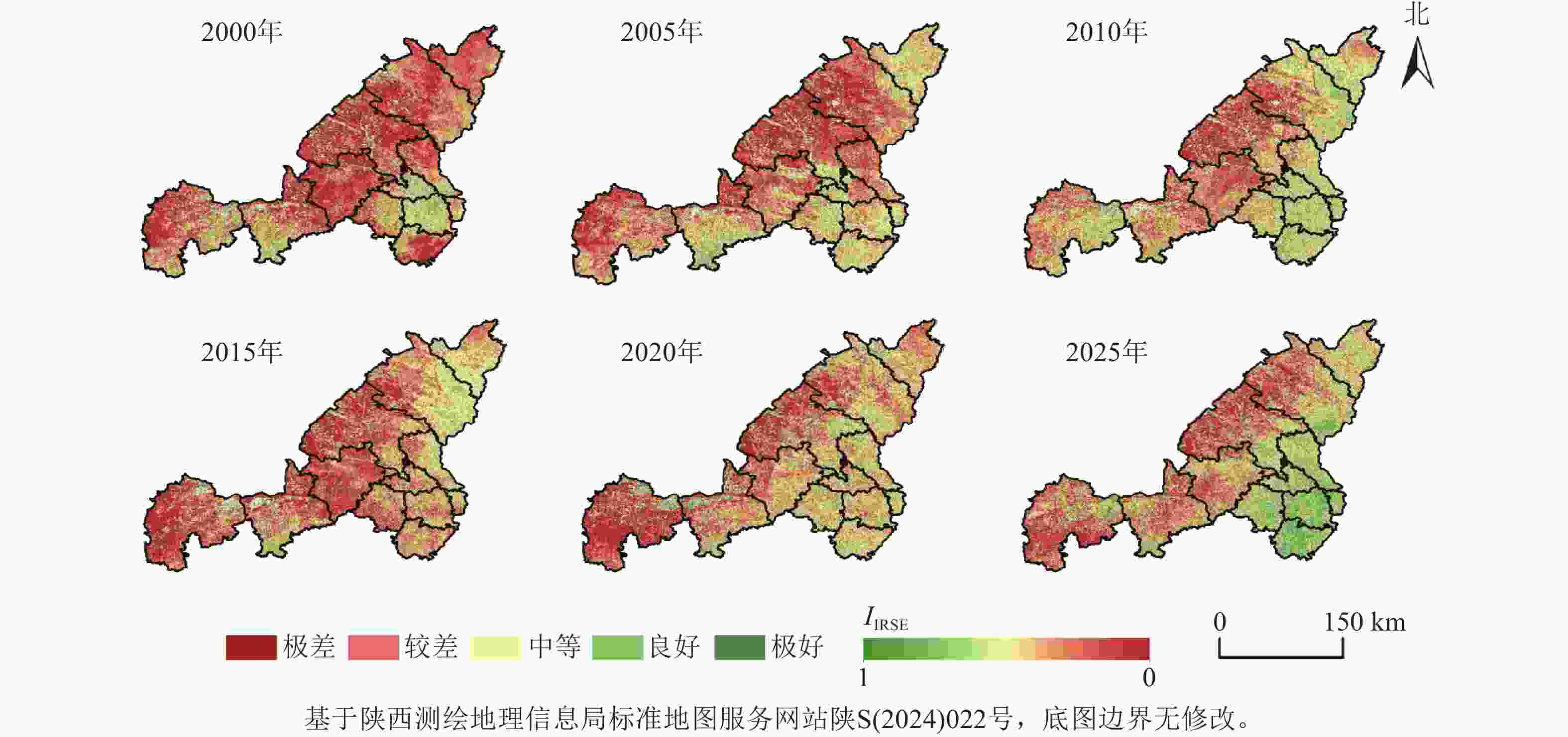
      Figure 3.  Spatial distribution of IRSEI in Yulin City from 2000 to 2025

    • 以2025年为基准年,统计像元在各时点的等级转换次数,并划分为3类:稳定区(0次)、低频区(1~3次)、高频区(4~5次)[38],得到IIRSE变化频率图谱。如图4所示:稳定区面积占比为17.57%,主要集中于西北部的毛乌素沙地和榆阳区已建成区;低频转换区占比达57.61%,广泛分布于中西部干旱半干旱区,受气候限制影响变化频率较低;高频转换区占比为24.82%,主要位于生态质量改善较大的东南部区域,包括佳县、吴堡、米脂、绥德、子洲、清涧等地。
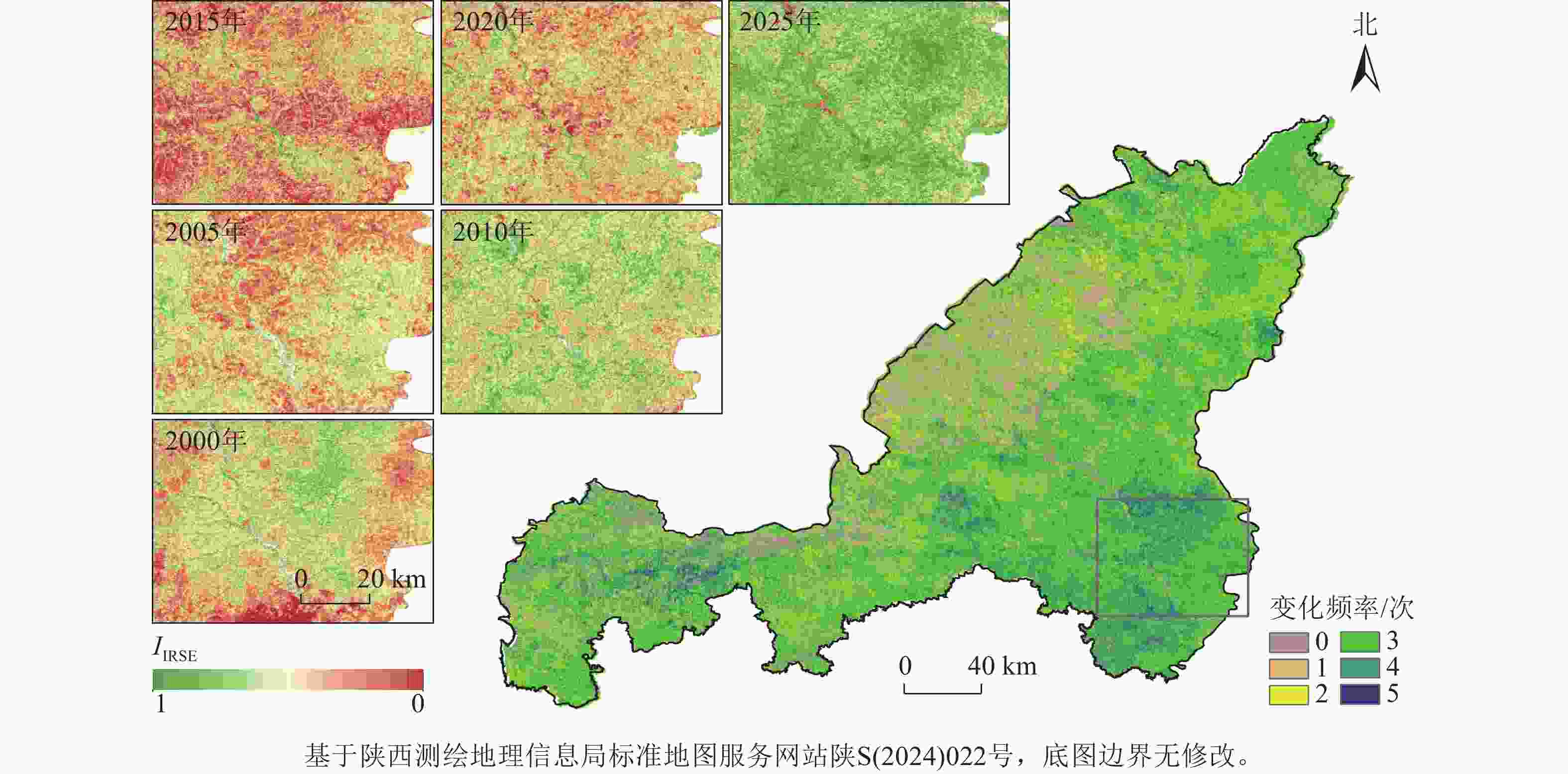
      Figure 4.  Frequency spectrum of IIRSE changes in the Yulin city from 2000 to 2025

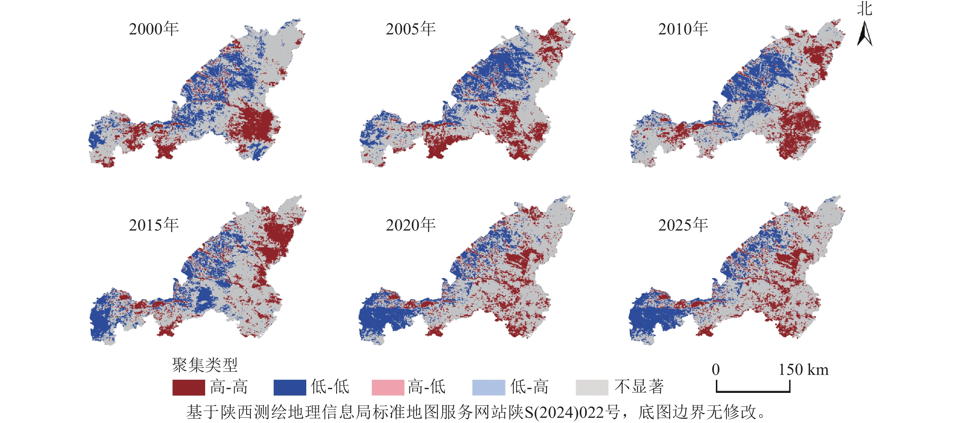
    • 基于LISA局部空间自相关分析方法,构建榆林市2000—2025年IIRSE聚类图,识别出高-高(H-H)、低-低(L-L)、低-高(L-H)、高-低(H-L)及不显著区5类空间结构。如图5所示:榆林市生态环境空间分布呈现明显的集聚特征,高值与低值区域相对集中,表明IIRSE空间自相关性较强。H-H聚集区主要分布于吴堡、绥德、清涧等县,这些区域具有较强的正相关特性,位于黄土高原沟壑区,地形起伏较大、降水相对充沛,植被恢复基础良好,同时“退耕还林”等生态工程实施力度较强,使得区域生态质量整体较高并呈现集聚态势;L-L聚集区主要集中于西部定边、榆阳区、神木等西部能源开采和干旱半干旱区,这些区域降水稀少,高程较低,风蚀、沙化严重,加之煤炭资源开发和土地利用强度增加,导致生态环境质量持续处于较低水平。总体来看,L-L和H-H具有明显的聚集特征,占比较大。L-H和H-L分布零散,占比相对较小。
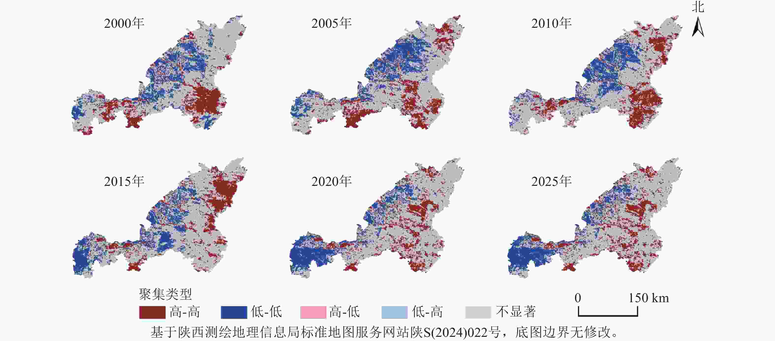
      Figure 5.  LISA cluster maps in Yulin City from 2000 to 2025

      从时间演变来看,H-H聚集区面积2000—2010年呈持续增长态势,2010—2020年有所下降,2020—2025年再次增加,2000—2025年H-H聚集区占比为17.63%、18.17%、18.73%、17.44%、16.42%、20.74%,反映出生态环境质量的长期优化趋势。2000—2025年L-L聚集区占比为19.96%、20.13%、18.35%、19.85%、19.09%、20.79%,表明生态低质量区域基本不变。

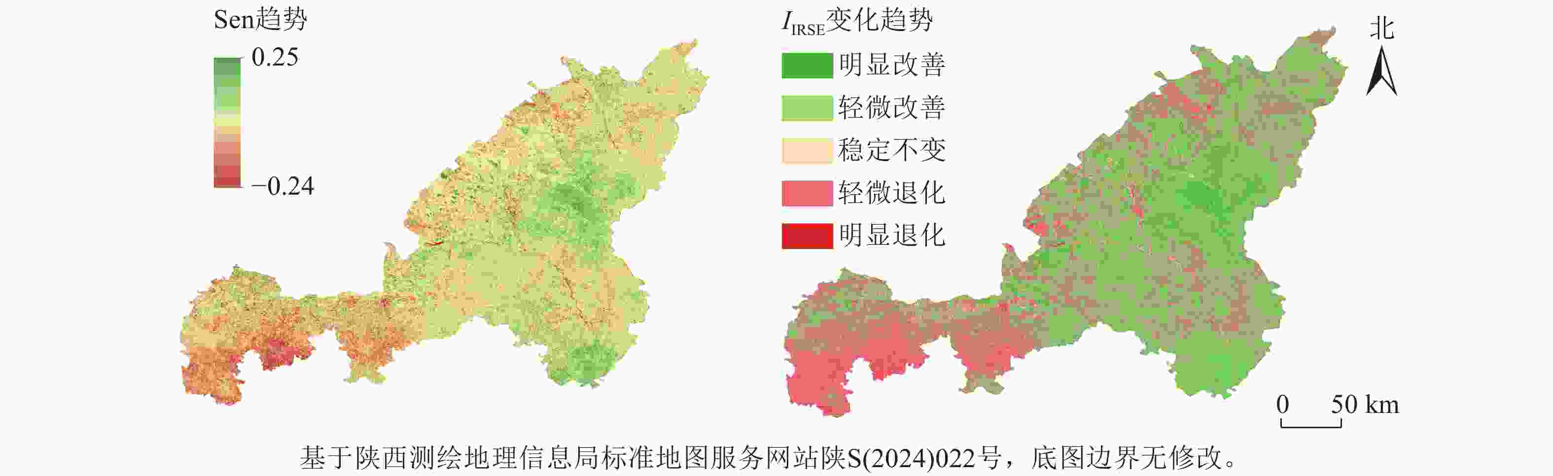
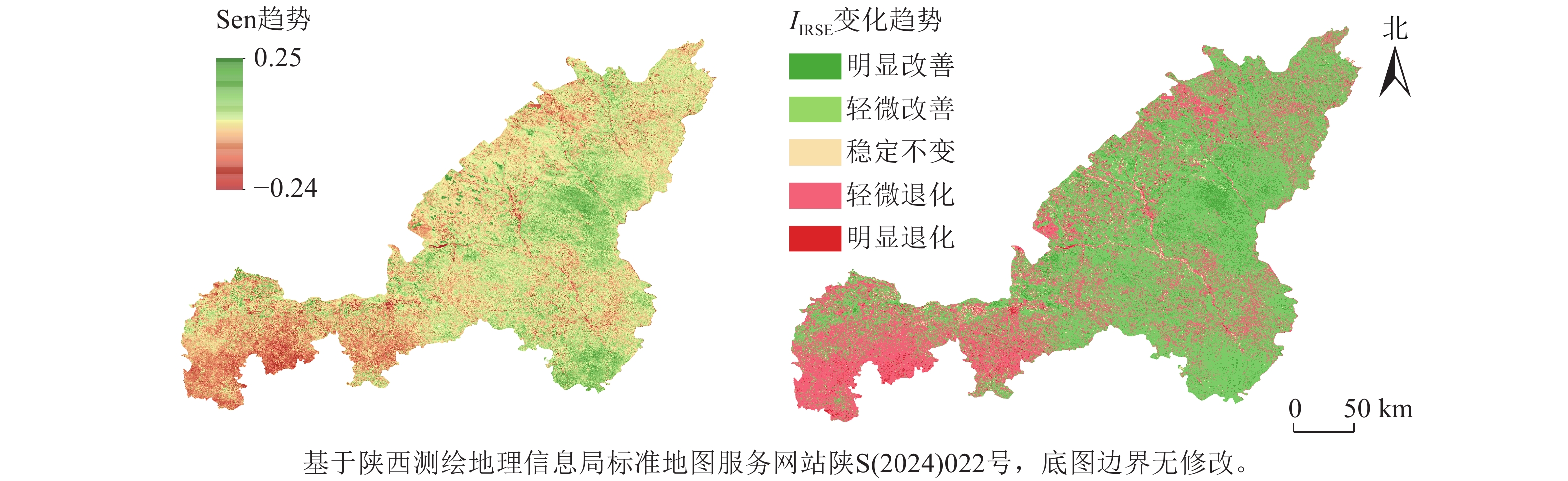
    • 采用Theil-Sen趋势分析和Mann-Kendall检验法对2000—2025年榆林市IIRSE的演变趋势进行定量识别(图6)。当趋势值大于0时,表明生态环境质量呈改善趋势;反之,则表示生态质量退化。结果显示:研究期内榆林市整体生态环境质量呈改善态势,其中显著改善区占5.41%,轻微改善区占59.42%,轻微退化区占31.85%,显著退化区仅占1.05%。

      Figure 6.  Trend value of Sen and trend of IIRSE in Yulin City from 2000 to 2025

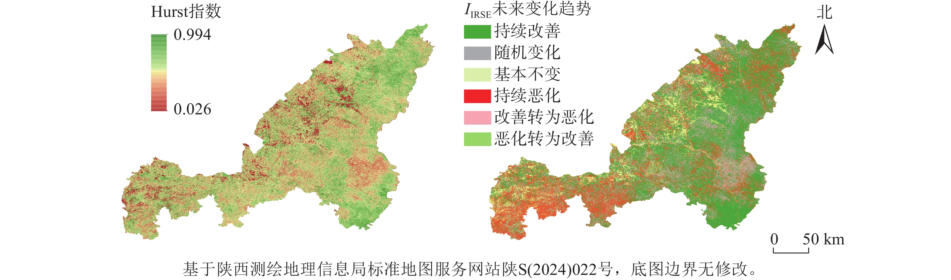
      在此基础上,利用Hurst指数对未来生态变化趋势进行预测(图7)。结果表明:持续改善区占比为48.44%,23.31% 的区域可能存在退化风险,10.51%的区域未来趋势基本稳定,10.50%的区域趋势表现不确定。空间上看,持续改善区主要集中在榆林市中部及东南部的神木市、佳县、子洲县、吴堡县、清涧县等地。
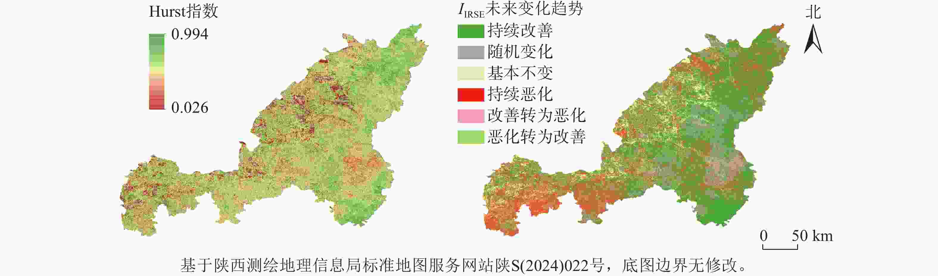
      Figure 7.  Values of Hurst index and future trends in ecological environment quality in Yulin City

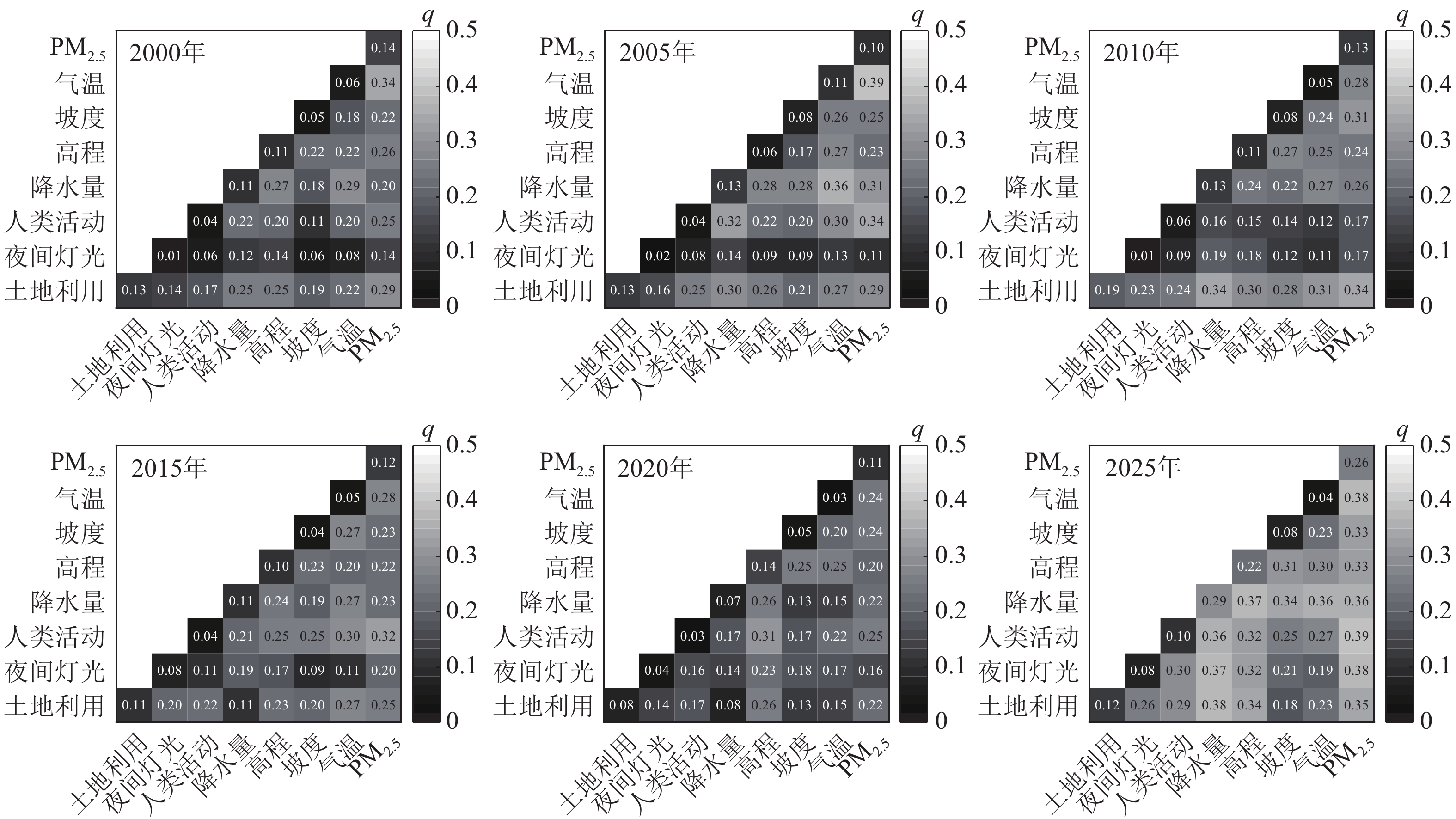
    • 在所选的8个驱动因子中(图8),自然因子的贡献更大,其中高程和降水量对IIRSE的解释力最高,榆林地处半干旱区,降水直接影响土壤水分供应和植被生长,是制约区域植被恢复与退化的关键因子。而高程与坡度则间接作用于生态环境质量:高海拔地区气候湿润,植被恢复条件较好,而坡度较大的区域耕作受限,退耕还林后更容易实现植被恢复,从而表现出较高的生态质量水平。在人为因素中,土地利用类型对生态质量变化的影响最为突出,能源开发和城市扩张导致耕地和建设用地增加,使区域生态承载力下降。
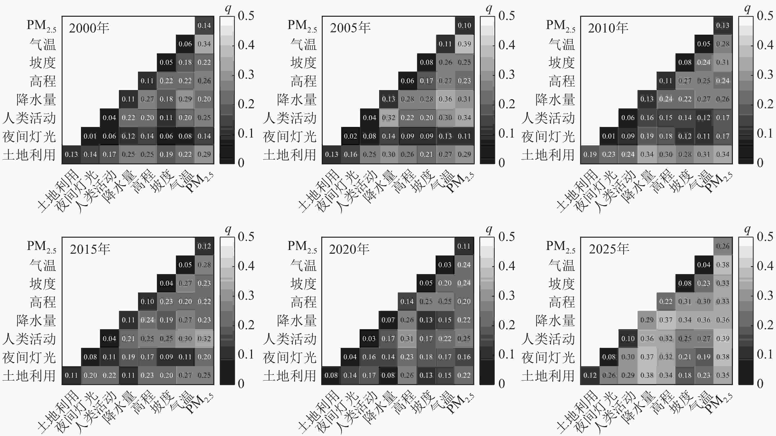
      Figure 8.  Factor interaction detection results

      从时间序列看,主导因子呈现一定阶段性差异:2000年为气温与PM2.5,2005年为气温与PM2.5,2010年为土地利用类型和PM2.5,2015年为人类活动强度与PM2.5,2020年为人类活动强度与高程,2025年为人类活动强度与PM2.5。PM2.5在全周期中均表现为最主要解释因子,榆林市作为国家重要的煤炭和天然气生产基地,榆林的煤矿开采、煤化工及燃煤电厂排放是 PM2.5 的主要贡献源。PM2.5不仅影响太阳辐射降低光合作用效率,还会通过大气沉降改变土壤和水体环境,对区域生态质量产生负面影响。气温在前期与PM2.5的交互作用更强,而2010年后土地利用和人类活动等人为因素的作用增强,说明随着时间的推移,人为因素对生态质量的改变起着越来越重要的作用。

      综合各因子的影响力排序从高到低依次为:降水、PM2.5、高程、土地利用类型、坡度、气温、人类活动强度、夜间灯光,说明自然因子在IIRSE演变中发挥主导作用,而社会经济因子则主要通过土地利用变化间接影响生态质量,二者的交互作用可进一步加剧生态环境质量的时空分异。

    • 榆林市地处黄土高原与毛乌素沙地的过渡带,生态环境敏感,其IIRSE空间分布格局受自然地理条件与人类活动双重作用影响。基于主成分分析提取的IIRSE结果表明:2000—2025年榆林市生态环境质量在空间上总体呈现“东南优、西北劣”的格局:毛乌素沙地生态脆弱,指数长期偏低,而东南部黄土丘陵沟壑区受益于大规模生态工程实施,生态质量提升。这一空间分异与研究区“黄土丘陵沟壑区-沙地过渡区”的地貌格局及土地利用结构高度相关,与既有研究结论亦基本一致[39]

      生态质量较优区域主要集中在佳县、米脂县、绥德县、子洲县、清涧县等东南部丘陵沟壑区。该区域气候条件相对湿润,叠加长期水土保持与“山水林田湖草沙”一体化等生态治理工程的实施,形成了生态斑块完整、景观连通性强的良性格局[40]。相对而言,定边县、神木市、榆阳区等西北部干旱区生态质量较差。该区域沙地分布广泛,降水稀少,土地开发强度大,IIRSE长期处于较低水平。近年来,毛乌素沙地综合治理取得阶段性成效,西北部低质量生态区范围有所收缩,但整体脆弱性依然突出。IIRSE高频转化区主要分布于东南部生态环境质量改善区域,该区为黄土丘陵沟壑区水土流失治理重点区域,生态修复成果与“从峁顶到沟底,层层设防、节节拦蓄”的3道防线模式成效形成空间响应。

    • 2000—2025年,榆林市IIRSE整体呈波动上升态势,均值由0.313提升至0.437,年均增长率为1.34%,表明区域生态环境质量持续改善。其改善动力主要来自2个方面:一是西北地区自21世纪以来气候暖湿化趋势持续增强,对区域生态恢复起到促进作用[21];二是大规模生态修复工程的持续实施。分阶段来看,2000—2010年,得益于榆林市1999年启动的退耕还林工程及2001年实施的第二阶段“三北”防护林建设,IIRSE提升较大;2010—2025年,随着城市化进程加快,资源型经济发展压力加大,土地利用变化频繁,生态改善速度趋缓,但整体仍保持稳定上升态势。尤其是西北部区域IIRSE持续升高,与2000—2022年毛乌素沙地绿洲化进程相一致,进一步验证了“三北”防护林工程中灌木固沙措施的有效性[41]。据陕西省荒漠化和沙化监测报告显示:截至2020年,榆林沙化土地治理率达93.24%,生态质量明显改善。

      空间频率分析表明:榆林市约57.61%的区域处于低频转换状态,生态系统稳定性较强;而东南部丘陵区呈现高频变化,反映出生态修复与人类开发活动的长期博弈。LISA空间自相关分析进一步揭示:生态质量的空间集聚性持续增强,其中H-H聚集区不断扩展,而L-L聚集区基本保持稳定,表明优质生态斑块正在强化。

    • 本研究仍存在一定的不确定性。首先,选取了8个驱动因子来探讨IIRSE的变化,但生态系统作为一个复杂耦合系统,其影响因素多元且在不同时间与空间尺度下作用强度差异较大。例如,在城镇建成区,人类活动对生态质量的干扰效应更为突出。为更直观地表征人类活动差异,采用夜间灯光指数作为代理变量[42],但其对生态质量的作用机制仍需进一步验证。其次,榆林市作为陕西省重要的能源化工基地,煤炭、石油、天然气等矿产资源丰富。大规模采矿活动在推动经济发展的同时,也导致土地退化、水体污染和大气污染等负外部性,威胁生态系统稳定性与居民健康。然而,如何在定量尺度上准确刻画采矿活动对区域生态质量的影响程度,仍是亟待深入研究的问题。

      东南丘陵沟壑区需持续开展水土保持与土地整治工程,巩固治理成效;西北毛乌素沙地则应重点实施退耕还林、草灌混播与固沙封育等措施,构建稳定的防风固沙屏障。同时,应完善以“三北”防护林、退耕还林和矿区修复为核心的生态工程协同机制,明确治理的空间覆盖、技术路径和时序安排,推动治理措施的科学化与长效化。进一步的研究可在更精细化的时空尺度上,综合考虑气候变化、能源开发与政策干预的作用机制,以期为资源型城市的绿色转型与区域可持续发展提供更具科学性的决策支持。

    • 2000—2025年,榆林市生态环境质量整体持续改善。IIRSE年均增长率为1.34%,空间格局呈西北低、东南高,整体达中等及以上水平;生态环境质量总体格局主要由降水等自然因子主导,土地利用类型在社会因子中贡献较大,而夜间灯光等人类活动指标影响相对有限;超过64.83%的区域呈改善趋势,东南丘陵区提升最大,表明生态修复成效明显。Hurst指数显示区域整体仍具持续改善潜力。未来应坚持分区治理,重点加强西北沙地与能源开采区生态修复,巩固东南丘陵区水土保持成效。

Reference (42)

Catalog

    /

    DownLoad:  Full-Size Img  PowerPoint
    Return
    Return