


-
在全球气候变化和人为剧烈活动的大环境背景下,河川径流在时间和空间上的变化,能够引起水资源的重新分配,并改变生态系统的演化过程[1]。揭示气候和水文水资源与生态环境的相互作用,可以为森林资源和水资源的合理开发、科学规划提供理论基础[2]。森林植被作为陆地生态系统的重要组成部分,在碳循环系统中也发挥着重要的影响力。森林植被连接着土壤层和大气层,具有截留降水、减少雨滴击溅、增加土壤入渗等生态功能[3]。森林植被的枯枝落叶层可以降低径流流动速度,增加径流渗透时间,提高地表径流入渗量,因此在减少水资源流失方面起着决定性的作用[4]。以往许多国内外学者进行了降雨量对径流影响作用大小研究[5-9],而植被对径流变化的影响研究较少,尤其是在中国南方红壤丘陵区。一些森林植被对产流的影响研究中没有考虑森林质量的差异,特别是地表覆盖的差异[10]。为了分析不同时期森林质量水平和变化规律,探讨径流变化趋势及其对植被变化的响应关系,进一步分析森林质量的变化对径流产生的影响,本研究以江西省石城县域1989−2018年的天然降雨、径流序列数据为基础,运用小波分析等方法对石城降雨径流进行研究,并结合石城县域1989、1995、2001、2004、2010和2017年6期遥感影像,计算森林质量指数,最终获得石城县域的降雨-森林-径流三维空间模型。研究结果可为定量监测和科学评价南方红壤丘陵区水土流失与生态环境状况提供依据,指导南方红壤丘陵区的水土流失综合治理和水文水资源研究,进一步增强森林涵养水源功能价值评估科学性,为解决县域低效林改造提供理论指导。
-
石城县位于江西省赣州市东北部,25°57′47″~26°36′13″N,116°05′47″~116°38′03″E。石城县域属长江流域赣江水系,境内水系发达,河流密布,全县大小河溪140条。石城县主要河流琴江河发源于高田镇,主河长143 km,流域面积大于100 km2的一级支流有3条,平均河网密度为0.69 km·km−2。除部分河流外,其余河流均在县境汇入琴江河,流域独立性强,县域面积为1 581.53 km2。境内为武夷山脉的山间盆地,东、北、西三面环山,主要分为中低山、丘陵、单斜盆地3个类型。山地、丘陵约占全县总面积的79%。石城县地处中亚热带中南部,水热条件优越。森林植被以马尾松Pinus massoniana林、杉木Cunninghamia lanceolata林为主,其中马尾松林面积较大。20世纪80年代初,全县水土流失面积506.00 km2,占县域总面积的32%,其中:强烈及以上水土流失面积150.47 km2,中度水土流失面积125.66 km2,轻度水土流失面积229.87 km2。严重的水土流失易造成自然灾害,如山体滑坡、洪涝等。
-
本研究所使用1989−2018年的水文数据包括径流实测数据、降雨实测数据等均来自江西省南昌市水文局水文观测站(琴江河石城站)位于琴江河下游,流域集水面积为656 km2。本研究中的遥感影像数据以Landsat 4、5、8卫星影像为数据源。在中国科学院计算机网络信息中心地理空间数据云平台(http://www.gscloud.cn)下载1989、1995、2001、2004、2010和2017年冬季无云覆盖的TM影像,其空间分辨率为30 m。森林资源二类调查数据来源于江西省石城县林业局。
-
通过植被覆盖度、林冠郁闭度和地表凋落物覆盖度对森林质量等级因子值进行判定,进而通过等级面积相应比例得出森林质量指数。植被覆盖度通过遥感影像图提取研究区域的土地覆盖分类图[11-14],并利用软件envi 5.2计算;林冠郁闭度和地表凋落物覆盖度通过森林资源二类调查数据和实地调查数据进行判定和划分。森林质量指数判定公式:
$$ \beta = \mathop \sum \limits_{i = 1}^5 {Q_i}\frac{{{S_i}}}{S}{\text{。}} $$ (1) 式(1)中:Si为等级面积,S为研究区总面积,Qi为森林质量等级因子值,β为森林质量指数。森林质量等级因子值确定范围可参考表1[15]。
表 1 森林质量等级因子值确定范围
Table 1. Forest quality grade factor value determination range
林冠郁
闭度地表凋落物
覆盖度植被覆盖
度/%森林质量等级
因子值≤0.10 无覆盖 <30 0.00~0.10 0.10~0.25 较低 30~45 0.10~0.25 0.25~0.50 一半 45~60 0.25~0.50 0.50~0.75 较高 60~75 0.50~0.75 >0.75 全覆盖 >75 0.75~1.00 -
小波变换是一种信号的时间-尺度分析方法[16-20],它具有很多分辨率分析的特点,而且在时、频两域都具有表征信号局部特征的能力,是一种窗口大小固定不变但其形状、时间和频率窗都可以改变的时频局部化分析方法[21]。在低频部分具有较高的频率分辨率,在高频部分具有较高的时间分辨率和较低的频率分辨率,很适合于探测正常信号中夹带的瞬间反常现象并展示其成分[19]。小波函数定义为:设
$\psi \left( t \right)$ 是平方可积函数,即ψ(t)∈L2(R),其傅里叶变换为$\hat \psi \left( \omega \right)$ 满足允许条件:$$ {C_\psi } = {\int\limits _R}\frac{{\left| {\hat \psi \left( \omega \right)} \right|^{\rm{2}}}}{{\left| \omega \right|}}{\rm{d}}\omega {\text{<}} \infty {\text{。}} $$ (2) 式(2)中:Cψ为容许函数,ψ(t)为一个基本小波或母小波,其中L2(R)表示满足
$\int\limits_R {{{\left| {f\left( t \right)} \right|}^2}} {\rm{d}}t {\text{<}} \infty $ 的函数空间。小波函数ψ(t)有2个基本特点:快速衰减性和震荡性[22]。 -
森林植被可以拦截部分降雨,其中林冠层和地表凋落物层起到主要的拦截作用。当降雨强度一致时,有植被覆盖的区域和无植被覆盖的区域会对径流产生不同的影响,有时差别很大。本研究尝试建立模型,定量描述降雨、径流和森林植被之间的响应关系,探索三者之间的变化规律。根据水量平衡理论,森林植被拦蓄降雨越多,研究区域产生的径流越少,森林拦蓄降雨能力大小与拦蓄容量有关。本研究森林拦蓄降雨模型采用刘昌明[23]的森林拦蓄降雨极限容量模型:
$$ Q=P-I_{\rm{T}}=P-\frac{1}{K}\left(1-{\mathrm{e}}^{-KP}\right){\text{。}} $$ (3) 式(3)中:Q为径流深(mm);P为降雨量(mm);IT为森林拦蓄降雨量,K为拦蓄率随降雨量递减的速度,与森林覆盖率(
$\alpha $ )密切相关。$ I_{\rm{TM}}=\dfrac{1}{K} $ ,ITM为森林最大可能拦蓄降雨;刘道平[24]在ITM=b$\alpha $ +c的假设基础上,提出如下模型改进:$$ Q\left(P,\;\alpha \right)=P-\left(b\alpha +c\right)\left(1-{\mathrm{e}}^{-\frac{P}{b\alpha +c}}\right){\text{。}} $$ (4) 式(4)中:b和c为系数。刘道平[24]的研究对象浙江省安吉县森林多年变化相对较小。森林植被对降水径流的影响较为复杂。以前,森林覆盖率(
$\alpha $ )对流域产流产沙的影响研究中没有考虑森林质量的差异,特别是地表覆盖的差异,而不同地表覆盖的森林水源涵养及土壤保持功能差异巨大[25]。石城县由于战争等历史原因,森林覆盖率及森林质量变化较大,仅考虑森林覆盖率,研究误差较大。为提高模型的精确度,本研究采用森林质量指数(β)代替森林覆盖率(%),径流预测模型则为:$$ Q\left(P,\;\beta \right)=P-\left(b\beta +c\right)\left(1-{\mathrm{e}}^{-\frac{P}{b\beta +c}}\right){\text{。}} $$ (5) 式(5)中:Q、β、P分别表示径流深、森林质量指数、降雨量。
-
本研究采用降雨量的丰枯等级变化,该等级变化以距平百分率X作为划分标准,分为丰年、平年、枯年,X=(
${\overline P_i} $ −${\overline P_{30}} $ )/${\overline P_{30}} $ ,其中:${\overline P_i} $ 为某年平均降雨量,${\overline P_{30}} $ 为30 a平均降雨量。具体的划分标准:当−0.1<X≤0.1时为平水年;当X>0.1为丰水年;当X≤−0.1时为枯水年[26]。对石城县域1989−2018年降雨观测资料进行统计分析,并统计年内丰水期(1−3月、10−12月)、枯水期(4−9月)年际分布等特征。由表2可知:石城县域多年平均年降雨量为1 831.3 mm,其中丰水期为1 228.9 mm,枯水期为602.4 mm。石城县域降雨年际变化差异明显,最大年降雨量(2 724.0 mm)是最小年降雨量(1 074.8 mm)的2.5倍。石城县域丰水年、平水年、枯水年对应的年降雨量分别为2 340.9、1 795.3、1 416.8 mm。表 2 石城县域多年降雨统计分析
Table 2. Distribution characteristics of annual rainfall in Shicheng County
项目 年降雨量/mm 丰水期降雨量/mm 枯水期降雨量/mm 多年 1 831.3 1 228.9 602.4 丰水年 2 340.9 1 553.6 787.4 平水年 1 795.3 1 268.3 527.0 枯水年 1 416.8 936.0 480.8 -
为了反映径流的年际变化特征,采用降雨量的丰枯等级变化,对石城县域1989−2018年径流观测资料进行统计分析,并统计丰水年、平水年、枯水年径流特征(表3)。石城县域多年平均径流量为6.69 亿m3,年径流量总体呈缓慢下降趋势。最大年径流量为11.73 亿m3,最小年径流量为3.19 亿m3,前者为后者的5.1倍,说明石城县域的年际径流幅度变化极大。石城县域丰水年、平水年和枯水年对应的年均径流量分别是9.58、6.69和4.25 亿m3。丰水年年均径流系数最高,为0.63,之后是平水年和枯水年,年均径流系数分别为0.57、0.46。
表 3 石城县域年径流分布特征
Table 3. Distribution characteristics of annual runoff in Shicheng County
项目 年径流量/亿m3 年径流深/mm 年径流系数 多年 6.69 1 020.1 0.54 丰水年 9.58 1 459.6 0.57 平水年 6.69 1 019.9 0.63 枯水年 4.25 648.2 0.46 -
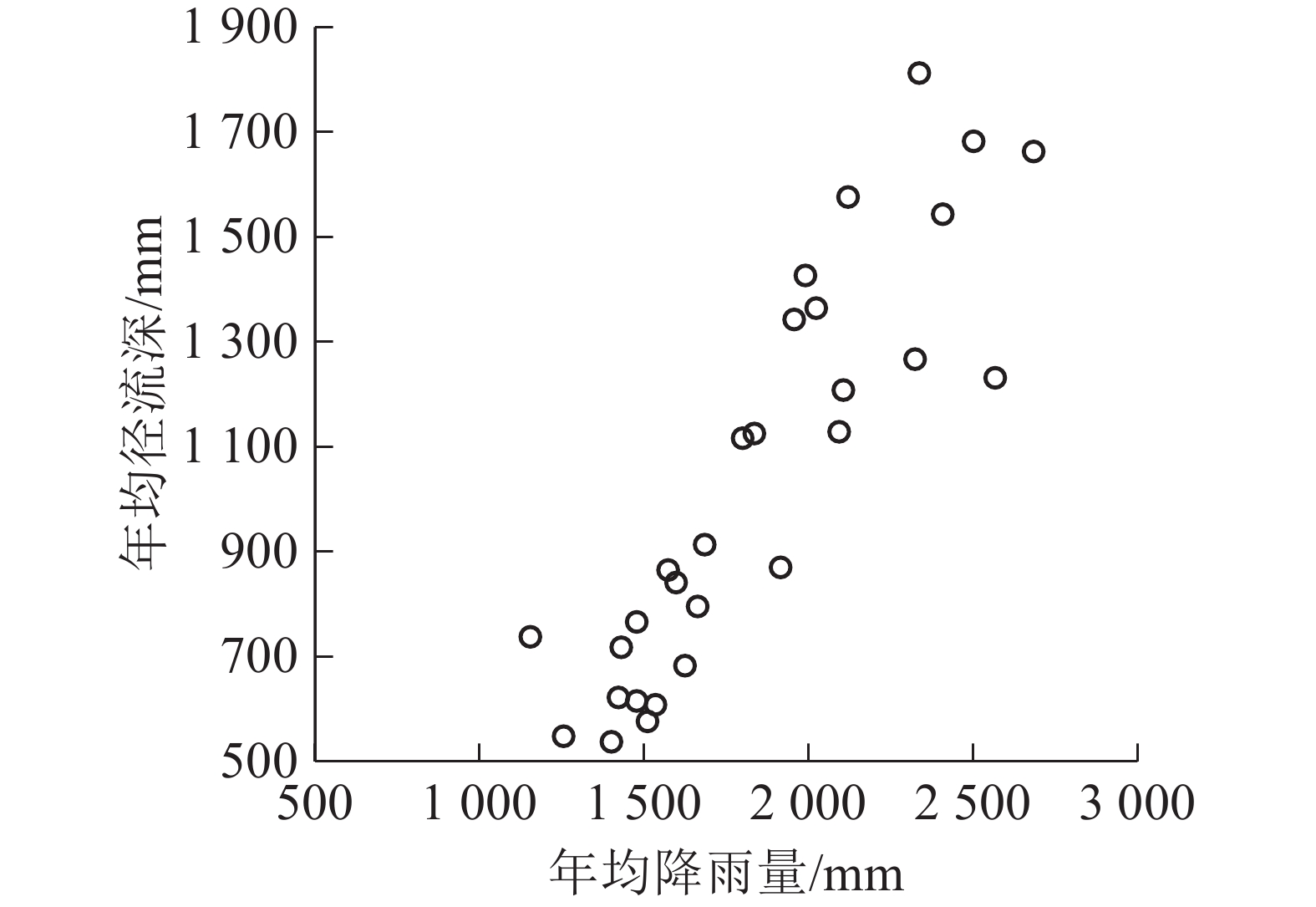
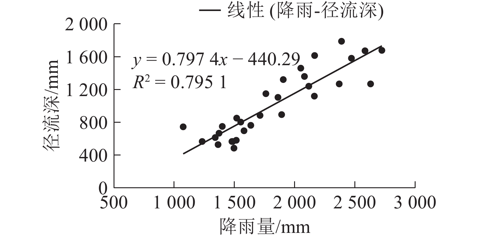
图1为石城县域多年降水量与径流深随时间的变化。从图1可以看出:在研究时段内,石城县域年降雨量和年径流深均呈正相关关系,即径流深随降雨量的增加而增加,相关系数R2为0.795 1。
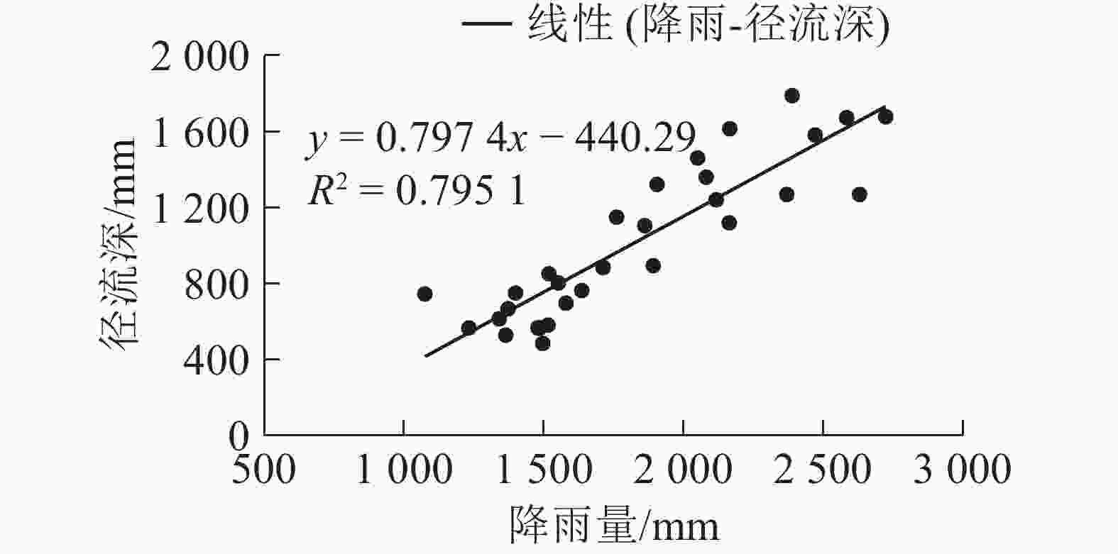
图 1 石城县域降雨量和径流深变化分析
Figure 1. Analysis of rainfall and runoff depth in Shicheng County
-
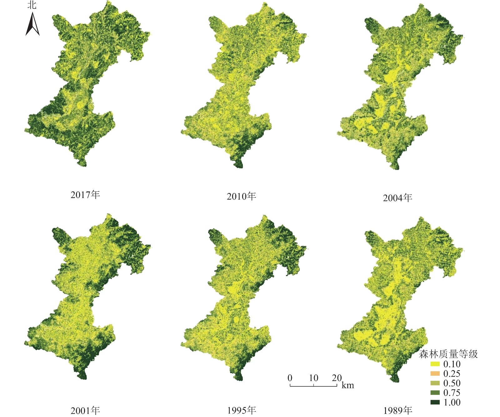
对石城县域1989、1995、2001、2004、2010和2017年6期遥感影像进行植被覆盖度计算,并根据森林质量等级因子值确定范围表提取得到石城县域的森林质量等级分布(图2)。

图 2 石城县域森林质量等级分布示意图
Figure 2. Distribution map of forest quality grade in Shicheng County
-
利用ArcGIS软件快速统计功能统计森林质量等级面积分布[27],并对其变化情况进行分析,如表4所示。为了提高结果的精确度,将年代划分为6个阶段,每阶段包括5个年份,分别是1989−1993、1994−1998、1999−2003、2004−2008、2009−2013、2014−2018年。石城县域森林质量指数随年份的增加整体呈上升—下降—上升趋势。石城县在20世纪60−70年代大量砍伐天然林,致使全县森林资源受到毁灭性破坏,森林质量指数较低。在20世纪80年代大面积采用飞播造林和人工植苗培育了马尾松林和杉木林,石城县域森林质量指数呈现上升趋势;2000−2010年,石城县由于抚育管理措施不当,出现了大面积的针叶纯林和低效低产林,森林质量指数有所下降;从2010年至今,森林培育管理技术的成熟和生产力的提高,特别是2000年以来,林下植被和枯枝落叶层恢复显著,森林质量要素中的地表覆盖率显著上升,石城县域森林质量指数呈现显著上升趋势。同时,20世纪90年代以来,相关政府部门越来越关注生态和环境问题,制定一系列政策,有效遏制了森林资源的破坏。此外,还开展了低效林改造、封山育林等项目,使得森林质量得到一定的改善。石城县域森林质量等级在0.50以上的面积比例整体均呈上升趋势。石城县域2017年较1989年森林质量指数在0.50以上的面积比例增加了66.54%,高质量林分占比越来越高。
表 4 森林质量等级面积分布
Table 4. Forest quality grade area distribution in each basin
森林质量等级 各年度面积/km2 1989 1995 2001 2006 2010 2017年 0.10 718.01 553.77 335.46 319.81 342.48 91.26 0.25 545.55 417.90 304.19 283.07 299.39 136.09 0.50 157.41 252.81 356.12 283.44 325.30 227.28 0.75 87.02 207.87 312.47 255.17 308.17 566.02 1.00 47.67 122.19 238.35 366.22 284.95 528.13 0.50及以上比例/% 18.78 37.49 58.63 60.01 58.86 85.32 -
结合水文数据实际情况,在1989−2018年隔5 a作为1个观测阶段,对各流域径流数据进行统计,分析石城县域降雨量、径流模数、径流量和径流系数等阶段变化(表5)。表5表明:石城县域径流系数同森林质量指数均呈相反的线性变化趋势,说明森林质量指数和径流系数呈负相关。分析原因可知:随着森林质量指数的增加,森林植被在截留降雨、促进土壤入渗方面作用越来越强。根据水量平衡理论可知,径流系数降低。
表 5 石城县域径流年代阶段特征
Table 5. Chronological characteristics of runoff in Shicheng County
所在流域 年份 森林质量
指数降雨量/
mm径流量/
亿m3径流深/
mm径流模数/
(m3·km−2·a−1)丰水期
径流深/mm枯水期
径流深/mm径流系数 丰水期
径流系数枯水期
径流系数石城县域 1989−1993 0.26 1 702.5 6.37 971.08 30.79 654.35 316.10 0.55 0.59 0.49 1994−1998 0.36 2 179.8 9.37 1 427.77 45.27 995.35 433.32 0.65 0.68 0.60 1999−2003 0.49 1 779.4 7.20 1 097.99 34.82 778.76 317.06 0.62 0.63 0.61 2004−2008 0.53 1 716.3 5.48 835.51 26.49 621.80 216.06 0.48 0.49 0.46 2009−2013 0.51 1 727.5 5.70 868.20 27.53 583.73 283.93 0.48 0.49 0.47 2014−2018 0.72 1 882.5 6.04 920.12 29.18 596.18 323.49 0.47 0.46 0.50 -
收集到的信号通常带有噪声,常见的噪声就有高斯白噪声。降雨-径流数据经过小波分析降噪处理后的时间序列散点图相比原始数据处理后的时间序列信号可表现出更好的相关性,时间序列信号熵值也由降噪处理变得更低,低频信息变得明显的同时会保留高频信息中的突变信号。图3是石城县域小波变换消噪后的降雨-径流数据。
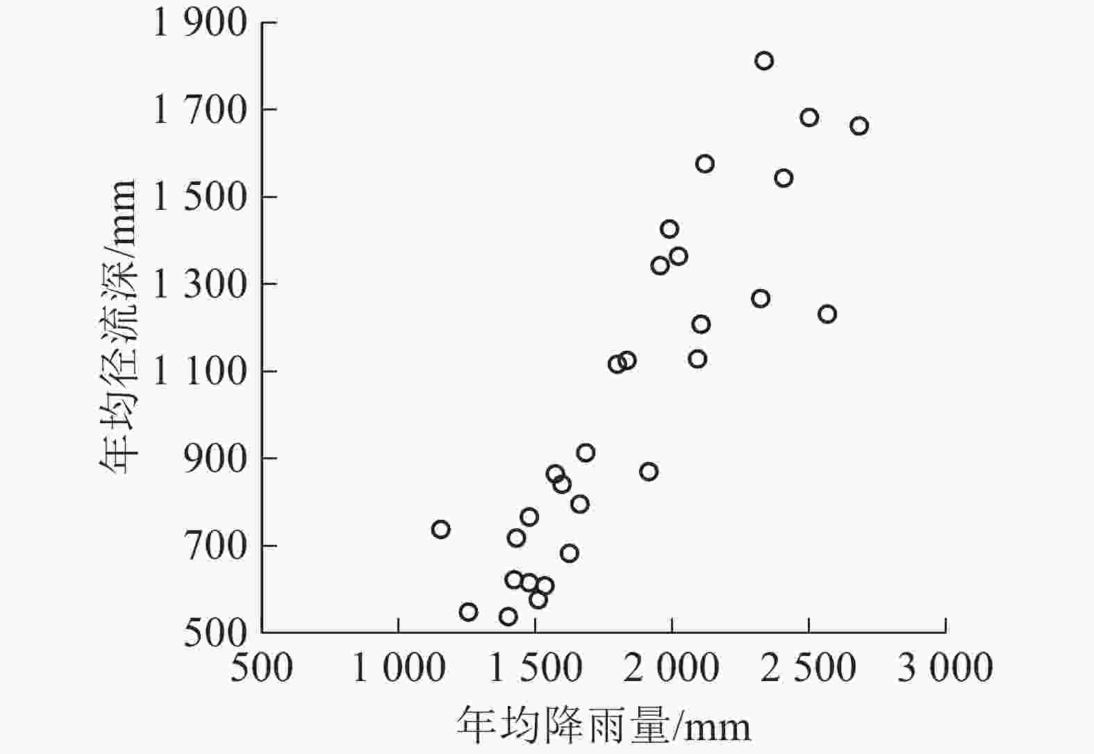
图 3 石城县域小波变换消噪后的降雨-径流
Figure 3. Path diagram of precipitation-runoff depth with wavelet de-noising in Shicheng County
结合经过小波变换后的降雨径流降噪数据以及森林质量指数数据,在软件Matlab上使用参数率定方法,模拟出最优结果值。经过筛选最优结果为:b=340.7,c=351.8,R2=0.951 9。因此,得到降雨-径流-森林模型表达式为:
$$ Q\left(P,\;\beta \right)=P-\left(340.7\beta +351.8\right)\left[1-\mathrm{e}\mathrm{x}\mathrm{p}\left(\frac{-P}{340.7\beta +351.8}\right)\right]{\text{。}} $$ 其中:P为降雨量(mm);β为森林质量指数(%);Q为径流深(mm)。
图4为石城县域模型三维空间图。分析模型可知:径流深与降水量呈正相关,与森林质量指数呈负相关。根据模型模拟,当降雨量为2 000.0 mm,森林质量指数为0.50时,径流深为1 489.0 mm;当降雨量为2 000.0 mm,森林质量指数为1.00时,径流深为1 346.0 mm。森林质量指数从0.50增加到1.00时,径流深减少了143.0 mm。随着森林质量指数的提高,径流深逐渐降低,表明石城县域森林质量的提升会加强森林涵养水源能力和森林滞洪作用。这与刘道平[24]模型拟合结果相同。而且,本模型在精度上较优,可定量监测和科学评价南方红壤丘陵区水土流失与生态环境状况,从而更好地实现对县域水资源变化的动态监测和预测。
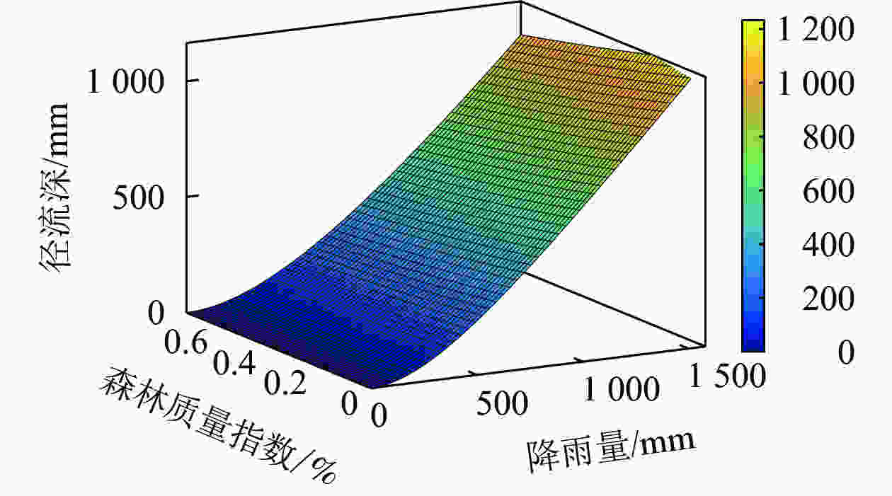
图 4 石城县域降水-径流-森林质量模型
Figure 4. Q-β-P model in Shicheng County
-
本研究以1989−2018年原始水文数据为基础,分析了江西省石城县域降雨和径流年际特征,并初步分析了降雨对径流的影响;再利用石城县域1989−2018年遥感影像数据,通过软件ENVI和ArcGIS运用新的公式算法得出石城县域的森林质量指数;最后通过软件Matlab的小波分析功能在降雨-径流二维平面分析的基础上,建立了关于降雨-森林质量-径流三维空间模型,以更好地表达三者之间的响应关系。主要结论如下:①石城县域1989−2018年多年平均降雨量为1 831.3 mm,丰水期多年平均降雨1228.9 mm,枯水期多年平均降雨量602.4 mm;多年平均径流量为6.69 亿m3,降雨和径流随着年际变化表现出缓慢下降趋势,下降趋势不明显。②石城县域森林质量指数随着解析年份的增加整体呈上升—下降—上升趋势;森林质量等级在0.50以上的面积比例整体均呈显著上升趋势;石城县域2017年较1989年森林质量指数在0.50以上的面积比例增加了66.54%。③石城县域径流系数同森林质量指数呈相反的线性变化,表明森林质量提升具有显著滞洪作用。④通过参数率定,建立了石城县域降雨-森林质量-径流模型,模型相关系数为0.951 9,其中径流深与降雨量呈正相关,与森林质量指数呈负相关。
Response of rainfall runoff to forest quality in Shicheng County, Jiangxi Province
-
摘要:
目的 分析江西省石城县域降雨径流和森林质量年代变化特征及规律,研究降雨-径流-森林之间的关系,为定量监测和科学评价南方红壤丘陵区水土流失与生态环境状况提供依据。 方法 根据石城县域1989−2018年的天然降雨、径流序列数据以及不同年代遥感影像图,采用小波分析、遥感监督解译及森林质量等级判定等方法。 结果 ①石城县域降雨径流随着年际变化表现出缓慢下降趋势,但下降趋势不显著;②森林质量指数随着解析年份的增加整体呈上升−下降−上升趋势;③森林质量提升具有显著滞洪作用;④建立石城县域小波模型,径流深与降雨量呈正相关,与森林质量指数呈负相关。 结论 森林质量的提升会加强森林涵养水源能力和森林滞洪作用。图4表5参27 Abstract:Objective The study aims to explore the characteristics and laws of the chronological change of rainfall runoff and forest quality in Shicheng County of Jiangxi Province, and the relationship between rainfall, runoff and forest, so as to provide basis for quantitative monitoring and scientific evaluation of soil erosion and ecological environment in the red soil hilly area in southern China. Method Based on the natural rainfall and runoff sequence data of Shicheng County from 1989 to 2018 and remote sensing image maps in different years, the methods of wavelet analysis, remote sensing supervision and interpretation, and forest quality grade determination were employed. Result (1) Rainfall and runoff showed a slow downward trend with inter-annual changes, but the decreasing trend was not significant. (2) The forest quality index showed an upward-downward-upward trend with the increase of resolution years. (3) The improvement of forest quality had a significant role in flood detention. (4) The wavelet model of Shicheng County showed the runoff depth was positively correlated with precipitation and negatively correlated with forest quality index. Conclusion The improvement of forest quality can strengthen the ability of forest water conservation and forest flood detention. [Ch, 4 fig. 5 tab. 27 ref.] -
Key words:
- forest hydrology /
- Shicheng County /
- rainfall /
- runoff /
- wavelet analysis /
- forest quality index
-
图 2 石城县域森林质量等级分布示意图
Figure 2 Distribution map of forest quality grade in Shicheng County
图 3 石城县域小波变换消噪后的降雨-径流
Figure 3 Path diagram of precipitation-runoff depth with wavelet de-noising in Shicheng County
表 1 森林质量等级因子值确定范围
Table 1. Forest quality grade factor value determination range
林冠郁
闭度地表凋落物
覆盖度植被覆盖
度/%森林质量等级
因子值≤0.10 无覆盖 <30 0.00~0.10 0.10~0.25 较低 30~45 0.10~0.25 0.25~0.50 一半 45~60 0.25~0.50 0.50~0.75 较高 60~75 0.50~0.75 >0.75 全覆盖 >75 0.75~1.00  下载: 导出CSV
表 2 石城县域多年降雨统计分析
Table 2. Distribution characteristics of annual rainfall in Shicheng County
项目 年降雨量/mm 丰水期降雨量/mm 枯水期降雨量/mm 多年 1 831.3 1 228.9 602.4 丰水年 2 340.9 1 553.6 787.4 平水年 1 795.3 1 268.3 527.0 枯水年 1 416.8 936.0 480.8
下载: 导出CSV
表 3 石城县域年径流分布特征
Table 3. Distribution characteristics of annual runoff in Shicheng County
项目 年径流量/亿m3 年径流深/mm 年径流系数 多年 6.69 1 020.1 0.54 丰水年 9.58 1 459.6 0.57 平水年 6.69 1 019.9 0.63 枯水年 4.25 648.2 0.46
下载: 导出CSV
表 4 森林质量等级面积分布
Table 4. Forest quality grade area distribution in each basin
森林质量等级 各年度面积/km2 1989 1995 2001 2006 2010 2017年 0.10 718.01 553.77 335.46 319.81 342.48 91.26 0.25 545.55 417.90 304.19 283.07 299.39 136.09 0.50 157.41 252.81 356.12 283.44 325.30 227.28 0.75 87.02 207.87 312.47 255.17 308.17 566.02 1.00 47.67 122.19 238.35 366.22 284.95 528.13 0.50及以上比例/% 18.78 37.49 58.63 60.01 58.86 85.32
下载: 导出CSV
表 5 石城县域径流年代阶段特征
Table 5. Chronological characteristics of runoff in Shicheng County
所在流域 年份 森林质量
指数降雨量/
mm径流量/
亿m3径流深/
mm径流模数/
(m3·km−2·a−1)丰水期
径流深/mm枯水期
径流深/mm径流系数 丰水期
径流系数枯水期
径流系数石城县域 1989−1993 0.26 1 702.5 6.37 971.08 30.79 654.35 316.10 0.55 0.59 0.49 1994−1998 0.36 2 179.8 9.37 1 427.77 45.27 995.35 433.32 0.65 0.68 0.60 1999−2003 0.49 1 779.4 7.20 1 097.99 34.82 778.76 317.06 0.62 0.63 0.61 2004−2008 0.53 1 716.3 5.48 835.51 26.49 621.80 216.06 0.48 0.49 0.46 2009−2013 0.51 1 727.5 5.70 868.20 27.53 583.73 283.93 0.48 0.49 0.47 2014−2018 0.72 1 882.5 6.04 920.12 29.18 596.18 323.49 0.47 0.46 0.50
下载: 导出CSV
-
[1] 杨飞. 气候变化和人类活动对水资源的影响研究[D]. 西安: 长安大学, 2011. YANG Fei. Study on the Impact of Climatie Change and Human Activities on Water Resources[D]. Xi’an: Chang’an University, 2011. [2] 张利平, 陈小凤, 赵志鹏, 等. 气候变化对水文水资源影响的研究进展[J]. 地理科学进展, 2008, 27(3): 62 − 69. ZHANG Liping, CHEN Xiaofeng, ZHAO Zhipeng, et al. Progress in study of climate change impacts on hydrology and water resources [J]. Prog Geogr, 2008, 27(3): 62 − 69. [3] 陈吉龙. 重庆市三峡库区植被覆盖度的遥感估算及动态变化研究[D]. 重庆: 西南大学, 2010. CHEN Jilong. Analysis of Vegetation Coverage and its Dynamic Change in the Three Gorges Reservoir Areain Chongqing based on Remote Sensing[D]. Chongqing: Southwest University, 2010. [4] 马琦, 王琦. 几种草被植物的水土保持效应研究[J]. 草业科学, 2005, 22(10): 72 − 74. MA Qi, WANG Qi. The effect of several grassy species on soil and water conservation [J]. Pratacultural Sci, 2005, 22(10): 72 − 74. [5] 龚倩倩. 不同尺度的径流变化规律分析研究[D]. 太原: 太原理工大学, 2011. GONG Qianqian. Analyze and Research the Regularity of Different Scales’ Runoff Variation[D]. Taiyuan: Taiyuan University of Technology, 2011. [6] 张晓艳, 刘梅先. 气候变化及人为活动对湘江流域径流和输沙的影响[J]. 水土保持研究, 2018, 25(1): 30 − 37. ZHANG Xiaoyan, LIU Meixian. Effects of climate change and human activities on water and sediment discharge in Xiangjiang Basin [J]. Res Soil Water Conserv, 2018, 25(1): 30 − 37. [7] CHEN Xiqing, ZONG Yongqiang, ZHANG Erfeng, et al. Human impacts on the Changjiang (Yangtze) River basin, China, with reference to the impacts on dry season water discharges sea [J]. Geomorphology, 2001, 41(2/3): 111 − 123. [8] YANG S L, GAO A, HOTZ H M, et al. Trends in annual discharge from the Yangtze River to the sea (1865−2004) [J]. Hydrol Sci J, 2005, 50(5): 825 − 836. [9] XIONG Lihua, GUO Shenglian. Trend test and change-point detection for the annual discharge series of the Yangtze River at the Yichang hydrological station [J]. Hydrol Sci J, 2004, 49(1): 99 − 112. [10] 王超. 黑河上游天老池流域植被变化对降雨径流过程影响研究[D]. 兰州: 兰州大学, 2013. WANG Chao. The Impact of Vegetation Change on Rainfall-runoff Process in Tianlaochi Catchment in Heihe River Basin[D]. Lanzhou: Lanzhou University, 2013. [11] 马娜, 胡云锋, 庄大方, 等. 基于遥感和像元二分模型的内蒙古正蓝旗植被覆盖度格局和动态变化[J]. 地理科学, 2012, 32(2): 251 − 256. MA Na, HU Yunfeng, ZHUANG Dafang, et al. Vegetation coverage distribution and its changes in Plan Blue Banner based on remote sensing data and Dimidiate Pixel Model [J]. Sci Geogr Sin, 2012, 32(2): 251 − 256. [12] 董显聪, 李晓洁. 草原植被覆盖度遥感估算模型的适用性比较[J]. 测绘通报, 2019(10): 17 − 22. DONG Xiancong, LI Xiaojie. Comparison of applicability of remote sensing estimation model for grassland vegetation coverage [J]. Bull Surv Mapp, 2019(10): 17 − 22. [13] 马秀秀, 王雅萍, 程结海, 等. 临汾市近20年植被覆盖度遥感估算及动态变化分析[J]. 能源与环保, 2019, 41(11): 11 − 18. MA Xiuxiu, WANG Yaping, CHENG Jiemei, et al. Remote sensing estimation and dynamic change analysis of vegetation coverage in Linfen City in recent 20 years [J]. China Energy Environ Prot, 2019, 41(11): 11 − 18. [14] 魏石磊, 翟亮, 桑会勇, 等. 像元分解模型的植被覆盖度遥感估算[J]. 测绘科学, 2016, 41(1): 139 − 143. WEI Shilei, ZHAI Liang, SANG Huiyong, et al. Remote sensing estimation of vegetation coverage based on sub-pixel analysis model [J]. Sci Surv Mapp, 2016, 41(1): 139 − 143. [15] 汪国春. 植被变化对流域产流产沙规律的影响研究[D]. 南京: 南京林业大学, 2018. WANG Guochun. Effect of Vegetation Change on Runoff and Sediment Yield in the Basin[D]. Nanjing: Nanjing Forestry University, 2018. [16] 刘永峰, 武俊, 王晓光. 1种基于小波阈值去噪的改进方法[J]. 电脑知识与技术, 2006(8): 154 − 155. LIU Yongfeng, WU Jun, WANG Xiaoguang. A new method based on wavelet thresholding denoising [J]. Comput Knowl Technol, 2006(8): 154 − 155. [17] 翟彦. 小波分析理论在信号处理中的研究及应用[D]. 昆明: 昆明理工大学, 2010. ZHAI Yan. Research and Application of Wavelet Analysis Theory in Signal Processing[D]. Kunming: Kunming University of Science and Technology, 2010. [18] 张仁辉, 杜民. 小波分析在信号去噪中的应用[J]. 计算机仿真, 2005, 22(8): 69 − 72. ZHANG Renhui, DU Min. Application of wavelet analysis in denoise processing [J]. Comput Simulation, 2005, 22(8): 69 − 72. [19] 张娜. 基于小波分析的网格结构信号预处理和去噪研究[D]. 南昌: 南昌大学, 2019. ZHANG Na. Signal Preprocessing and Denoising of Grid Structure Based on Wavelet Analysis[D]. Nanchang: Nanchang University, 2019. [20] 孔玲军. MATLAB小波分析超级学习手册[M]. 北京: 人民邮电出版社, 2014. [21] 张国培. 基于多尺度信号分量的复合结构损伤识别方法研究[D]. 北京: 北京交通大学, 2015. ZHANG Guopei. Study on Damage Detection Method of Composite Structure Based on Multi-resolution Signals [D]. Beijing: Beijing Jiaotong University. [22] 卓金武. MATLAB在数学建模中的应用[M]. 北京: 北京航空航天大学出版社, 2011. [23] 刘昌明. 水文水资源研究理论与实践[M]. 北京: 科学出版社, 2004. [24] 刘道平. 黄浦江上游水源林水文生态功能研究[D]. 南京: 南京林业大学, 2006. LIU Daoping. Study on Hydrological and Ecological Functions of Water Source Forest in the Upper Reaches of Huangpu River[D]. Nanjing: Nanjing ForestryUniversity, 2006. [25] 何玉广, 信忠保, 余新晓, 等. 模拟降雨条件下侧柏林地枯落物对坡面产流产沙的影响[J]. 水土保持学报, 2017, 31(3): 27 − 32, 38. HE Yuguang, XIN Zhongbao, YU Xinxiao, et al. Influence of litter layer of Platycladus orientalis forests on runoff and sediment yield of the slope under simulated rainfall [J]. J Soil Water Conserv, 2017, 31(3): 27 − 32, 38. [26] 代俊峰, 张学洪, 王敦球, 等. 北部湾经济区径流、降雨分配特点及其变化分析[J]. 中国农村水利水电, 2011(6): 6 − 8, 11. DAI Junfeng, ZHANG Xuehong, WANG Dunqiu, et al. Distribution characteristics and change trend of rainfall and runoff in Beibu Gulf [J]. China Rural Water Hydropower, 2011(6): 6 − 8, 11. [27] 李明飞. 基于ArcGIS的地类面积统计工具研发与应用[J]. 测绘与空间地理信息, 2019, 42(8): 135 − 137. LI Mingfei. Development and application of geographic area statistics tools based on ArcGIS [J]. Geomatics Spat Inf Technol, 2019, 42(8): 135 − 137. -

-
链接本文:
https://zlxb.zafu.edu.cn/article/doi/10.11833/j.issn.2095-0756.20200505
 点击查看大图
计量
- 文章访问数: 1847
- HTML全文浏览量: 611
- PDF下载量: 64
- 被引次数: 0


