LIN Yixin, CHEN Dandan, LIU Hongbo, et al. Identification of key amino acid residues controlling the activities of glycerol-3-phosphate acyltransferases in Arabidopsis thaliana and Brassica napus[J]. Journal of Zhejiang A&F University, 2023, 40(4): 695-706. DOI: 10.11833/j.issn.2095-0756.20220764
Citation: LUO Mengqi, DUAN Qian, JIANG Yaqiong, et al. Evaluation on the effect of National Key Soil and Water Conservation Project based on fine management of map spots[J]. Journal of Zhejiang A&F University, 2021, 38(1): 165-172. DOI: 10.11833/j.issn.2095-0756.20200168

Evaluation on the effect of National Key Soil and Water Conservation Project based on fine management of map spots

DOI: 10.11833/j.issn.2095-0756.20200168
  • Received Date: 2020-02-16
  • Rev Recd Date: 2020-09-11
  • Available Online: 2021-01-21
  • Publish Date: 2021-01-21
  •   Objective  This study aims to discuss the governance effect of the National Key Soil and Water Conservation Project after implementation.  Method  Taking the small watershed of Zhangjia Village in Mengyin County of Shandong Province as an example, and soil and water conservation in basic spot and effect spot as the unit, the changes of land use, forest and grass vegetation coverage, soil and water conservation measures, and soil and water loss before and after the implementation of the National Key Soil and Water Conservation Project were compared and analyzed through investigation, measurement and field review, based on high-resolution remote sensing, UAV, mobile terminal and other technologies.  Result  (1)After the implementation of the project, there were 339 plot changes, covering an area of 870.60 hm2. The change direction was mainly from slope farmland/dry terrace into orchards, followed by slope farmland into dry terrace. (2)The basic annual forest and grass coverage rate was 31.13%, and the assessed annual forest and grass coverage rate was 45.69%. The coverage rate was mainly medium and high (60%–75%), and the improvement rate of forest and grass coverage was 14.56%. (3) The conservation rate of soil and water conservation measures was the highest in reservoir (100.00%), the lowest in millet workshop (55.56%), and the conservation rate of other soil and water conservation measures was above 80.00%. (4) The area of soil and water loss reduced by 400.39 hm2 in the evaluation year compared with the base year, the reduction rate of soil and water loss was 23.21%, and the degree of soil and water loss control was 76.78%.  Conclusion  Through implementation of the National Key Soil and Water Conservation Project, the ecological environment in the small watershed of Zhangjia Village in Mengyin County has been significantly improved, which is mainly reflected in the reduction of soil and water loss and the increase of forest and grass vegetation coverage. [Ch, 5 fig. 5 tab. 11 ref.]
  • [1] SUN Zhanwei, MA Lan, MEI Xuemei, LIU Jingjing, WANG Fuxing, ZHANG Jinge, YAN Lin.  Characteristics of soil moisture and its main influencing factors in different hydrological years in western Shanxi loess region . Journal of Zhejiang A&F University, 2021, 38(1): 10-20. doi: 10.11833/j.issn.2095-0756.20200260
    [2] LIU Peng, WANG Yan, LIU Zongbin, GUO Yujing, ZHANG Zixia, LI Xiangwang, YANG Bo.  Distribution and division of stony desertification on county scale . Journal of Zhejiang A&F University, 2019, 36(5): 965-973. doi: 10.11833/j.issn.2095-0756.2019.05.016
    [3] ZHU Zhu, YANG Hailong, HUANG Qian, ZHAO Jiawei.  Health evaluation of typical water conservation forests in the alpine loess area of Qinghai . Journal of Zhejiang A&F University, 2019, 36(6): 1166-1173. doi: 10.11833/j.issn.2095-0756.2019.06.014
    [4] LIU Heling, RAO Liangyi, TU Ersun, TANG Lingpei.  Effect of water erosion and soil conservation measures on soil organic carbon content in rocky mountainous areas of northern China . Journal of Zhejiang A&F University, 2019, 36(4): 646-655. doi: 10.11833/j.issn.2095-0756.2019.04.003
    [5] SUN Yuhan, WANG Shibo, WANG Runhan, ZHENG Xiaoyu, YAN Fei.  Spatial structure of a Pinus tabulaeformis plantation based on the Voronoi diagram . Journal of Zhejiang A&F University, 2018, 35(5): 877-884. doi: 10.11833/j.issn.2095-0756.2018.05.012
    [6] LI Hualin, GAO Huaduan, YANG Tao, GAO Ruxue, SUN Quanzhong.  Sediment reduction with different vegetation types for the Kaizhang small watershed in a karst area . Journal of Zhejiang A&F University, 2017, 34(4): 687-694. doi: 10.11833/j.issn.2095-0756.2017.04.015
    [7] GAO Lei, RAO Liangyi, CUI Feibo, LI Zhibin, DU Liuhong, LIU Lifeng.  Soil and water conservation effects of plant measures in rocky areas of the Taihang Mountains . Journal of Zhejiang A&F University, 2017, 34(6): 1079-1086. doi: 10.11833/j.issn.2095-0756.2017.06.016
    [8] WANG Xiao-ming, ZHONG Shao-zhu, ZHOU Ben-zhi, CAO Yong-hui, WANG Gang.  GIS-based analysis of spatial characteristics of soil erosion in Fuyang . Journal of Zhejiang A&F University, 2011, 28(2): 280-286. doi: 10.11833/j.issn.2095-0756.2011.02.018
    [9] WANG Yi-ping, LIN Li-si, ZHENG Fang-dong, WU Hong.  Teinopalpus aureus firstly found in Zhejiang . Journal of Zhejiang A&F University, 2009, 26(1): 147-148.
    [10] SUN Da, ZHANG Miao-xian, HAN Jin, HUANG Fang.  Sediment and yield runoff with simulated rainfall on a barren slope . Journal of Zhejiang A&F University, 2008, 25(5): 635-638.
    [11] SONG Yu, JIANG Hong, YUShu-quan, ZHOUGuo-mo.  Landscape ecological analysis of soil erosion . Journal of Zhejiang A&F University, 2007, 24(3): 342-349.
    [12] MA Dan-dan, LI Gen-you, SHI Bai-lin, YE Xi-yang.  Lillium concolor var. pulchellum: a new geographical distribution plant in Zhejiang . Journal of Zhejiang A&F University, 2007, 24(1): 119-120.
    [13] SU Zeng-jian, YU Shu-quan, ZHOU Guo-mo.  Review of water and soil conservation technology on commercial forest of ecotype in Zhejiang . Journal of Zhejiang A&F University, 2002, 19(4): 440-445.
    [14] WU Shi-bao, CHEN Hai, LU Kai-he, WU Gui-sheng, ZHOU Xiang-tian.  Application of topographic map to investigation for wildlife resources . Journal of Zhejiang A&F University, 2001, 18(3): 301-304.
    [15] HU Guo-liang, YU Cai-zhu, LOU jun-fang, CHEN Xiao-zhong, XU Hui.  Bionomics and control of Takecallis taiwanus . Journal of Zhejiang A&F University, 2001, 18(3): 294-296.
    [16] LOU Jun-fang, XU Bing-chao, CHEN Xiao-zhong, WU Ji-lai, ZHONG Zhi-hua.  Biological characteristic and chemical control of Pseudalbara parvula . Journal of Zhejiang A&F University, 2000, 17(2): 229-231.
    [17] GAO Zhi-hui, CHEN Shun-wei, JIANG Miao-ding, KANG Zhi-xiong, SHI Zhong-li.  Water and soil conservation effectiveness of different types of vegetation on subtropical rocky coast . Journal of Zhejiang A&F University, 1999, 16(4): 380-386.
    [18] Xu Guanghui.  Upper bound on the least eigenvalue of unicyclic graphs . Journal of Zhejiang A&F University, 1998, 15(3): 304-309.
    [19] Hou Chenglin.  Study on Pathogenic Fungi of Acer buergrianum Leaf spot. . Journal of Zhejiang A&F University, 1995, 12(3): 268-270.
    [20] Xu Taifang, Xi Xinji, Jiang Minsheng.  Introduction and Breeding of Ontsira palliatus . Journal of Zhejiang A&F University, 1993, 10(1): 122-124.
  • [1]
    XING Wei, HU Xuli, ZHANG Ronghua, et al. Control effects of the national key project of soil and water conservation on the soil erosion in Huaihe River Basin [J]. Sci Soil Water Conserv, 2016, 14(2): 137 − 146.
    [2]
    ZHAO Aijun. The Research on Comprehensive Control Model in Small Watershed[D]. Wuhan: Huazhong Agricultural University, 2005.
    [3]
    ZHANG Songsong, HU Xuli, ZHANG Guangcan, et al. Effects of different tillage methods on the project of changing slope into terrace in small watersheds [J]. Sci Soil Water Conserv, 2015, 13(6): 91 − 97.
    [4]
    ZHAO Jianmin. The Study on the Comprehensive Benefit Evaluation for Soil and Water Conservation Based on the Theory of Ecosystem Services: A Case Study in Central Hilly-Gully Region on Loess Plateau[D]. Xi’an: Northwest A&F University, 2010.
    [5]
    LI Miaomiao. The Method of Vegetation Fraction Estimation by Remote Sensing[D]. Beijing: Chinese Academy of Sciences, 2003: 20 – 35.
    [6]
    ZHANG Hongda, WANG Baoyi, NIU Yong, et al. Application of ovitalmap in field survey of regional water and soil loss monitoring [J]. Sci Soil Water Conserv, 2018, 16(5): 85 − 94.
    [7]
    JIANG Dewen. Application of high resolution remote sensing and UAV in soil conservation monitoring and supervision [J]. China Water Resour, 2016(16): 45 − 47, 49.
    [8]
    ZHANG Yawen, XU Wensheng, SHEN Shengyu, et al. Application of UAV remote sensing technology in monitoring of soil and water conservation for construction projects: the establishment of a method [J]. Sci Soil Water Conserv, 2017, 15(1): 134 − 140.
    [9]
    TIAN Jiarong, DAI Tingting, XU Yannan, et al. Extraction of vegetation parameters in different stages of ecological restoration on abandoned mine area based on T-LiDAR [J]. J Ecol Rural Environ, 2018, 34(8): 686 − 691.
    [10]
    WANG Chunmei, YANG Qinke, WANG Qi, et al. Research on regional soil erosion intensity assessment: taking the Ansai County as an example [J]. Sci Soil Water Conserv, 2010, 8(3): 1 − 7.
    [11]
    QI Fei, HU Xuli, LIU Xia, et al. Soil and water conservation planning layout and measures configuration for Yiyuan County based on small watersheds [J]. Sci Soil Water Conserv, 2018, 16(5): 129 − 135, 144.
  • Created with Highcharts 5.0.7Amount of accessChart context menuAbstract Views, HTML Views, PDF Downloads StatisticsAbstract ViewsHTML ViewsPDF Downloads2024-052024-062024-072024-082024-092024-102024-112024-122025-012025-022025-032025-040Highcharts.com
    Created with Highcharts 5.0.7Chart context menuAccess Class DistributionFULLTEXT: 21.3 %FULLTEXT: 21.3 %META: 76.2 %META: 76.2 %PDF: 2.5 %PDF: 2.5 %FULLTEXTMETAPDFHighcharts.com
    Created with Highcharts 5.0.7Chart context menuAccess Area Distribution其他: 9.7 %其他: 9.7 %其他: 1.1 %其他: 1.1 %Baden: 0.3 %Baden: 0.3 %Brazil: 0.3 %Brazil: 0.3 %Canada: 0.3 %Canada: 0.3 %China: 1.8 %China: 1.8 %Edinburg: 0.2 %Edinburg: 0.2 %Egypt: 0.2 %Egypt: 0.2 %Elizabeth City: 0.1 %Elizabeth City: 0.1 %Italy: 0.1 %Italy: 0.1 %Philippines: 0.5 %Philippines: 0.5 %Russian Federation: 0.1 %Russian Federation: 0.1 %Seattle: 0.1 %Seattle: 0.1 %United States: 0.2 %United States: 0.2 %Wixom: 0.2 %Wixom: 0.2 %[]: 3.1 %[]: 3.1 %上海: 0.7 %上海: 0.7 %东莞: 0.1 %东莞: 0.1 %临汾: 0.1 %临汾: 0.1 %丹佛: 0.3 %丹佛: 0.3 %休斯敦: 0.5 %休斯敦: 0.5 %保定: 0.1 %保定: 0.1 %北京: 9.7 %北京: 9.7 %北伯根: 0.1 %北伯根: 0.1 %匹兹堡: 0.2 %匹兹堡: 0.2 %南京: 0.2 %南京: 0.2 %南昌: 0.1 %南昌: 0.1 %博阿努瓦: 0.1 %博阿努瓦: 0.1 %卢瓦尔: 0.2 %卢瓦尔: 0.2 %厦门: 0.1 %厦门: 0.1 %台州: 0.1 %台州: 0.1 %合肥: 0.1 %合肥: 0.1 %哥伦布: 0.1 %哥伦布: 0.1 %嘉兴: 0.6 %嘉兴: 0.6 %坦佩: 0.2 %坦佩: 0.2 %士嘉堡: 0.2 %士嘉堡: 0.2 %天津: 0.1 %天津: 0.1 %娄底: 0.1 %娄底: 0.1 %密蘇里城: 0.6 %密蘇里城: 0.6 %广州: 0.5 %广州: 0.5 %张家口: 1.7 %张家口: 1.7 %徐州: 0.1 %徐州: 0.1 %德国: 0.1 %德国: 0.1 %成都: 0.4 %成都: 0.4 %扬州: 0.1 %扬州: 0.1 %拉雷多: 0.1 %拉雷多: 0.1 %昆明: 0.2 %昆明: 0.2 %晋城: 0.1 %晋城: 0.1 %杭州: 3.7 %杭州: 3.7 %杭州市拱墅区: 0.1 %杭州市拱墅区: 0.1 %森尼韦尔: 0.2 %森尼韦尔: 0.2 %武汉: 0.3 %武汉: 0.3 %洛杉矶: 0.4 %洛杉矶: 0.4 %洛阳: 0.1 %洛阳: 0.1 %济南: 0.1 %济南: 0.1 %深圳: 0.3 %深圳: 0.3 %温州: 0.2 %温州: 0.2 %漯河: 0.6 %漯河: 0.6 %潍坊: 0.1 %潍坊: 0.1 %百色: 0.1 %百色: 0.1 %石家庄: 0.5 %石家庄: 0.5 %福州: 0.1 %福州: 0.1 %纽瓦克: 0.3 %纽瓦克: 0.3 %绍兴: 0.3 %绍兴: 0.3 %美国密歇根大急流城: 0.2 %美国密歇根大急流城: 0.2 %芒廷维尤: 8.0 %芒廷维尤: 8.0 %芜湖: 0.1 %芜湖: 0.1 %芝加哥: 0.3 %芝加哥: 0.3 %苏州: 0.3 %苏州: 0.3 %西宁: 41.7 %西宁: 41.7 %西安: 0.1 %西安: 0.1 %贵阳: 0.1 %贵阳: 0.1 %贺州: 0.1 %贺州: 0.1 %运城: 2.3 %运城: 2.3 %邯郸: 0.1 %邯郸: 0.1 %邵阳: 0.1 %邵阳: 0.1 %郑州: 0.9 %郑州: 0.9 %重庆: 0.2 %重庆: 0.2 %金华: 0.6 %金华: 0.6 %长沙: 0.7 %长沙: 0.7 %长治: 0.1 %长治: 0.1 %阳泉: 0.5 %阳泉: 0.5 %阿布奎基: 0.2 %阿布奎基: 0.2 %青岛: 0.2 %青岛: 0.2 %马鞍山: 0.1 %马鞍山: 0.1 %黔西南: 0.1 %黔西南: 0.1 %其他其他BadenBrazilCanadaChinaEdinburgEgyptElizabeth CityItalyPhilippinesRussian FederationSeattleUnited StatesWixom[]上海东莞临汾丹佛休斯敦保定北京北伯根匹兹堡南京南昌博阿努瓦卢瓦尔厦门台州合肥哥伦布嘉兴坦佩士嘉堡天津娄底密蘇里城广州张家口徐州德国成都扬州拉雷多昆明晋城杭州杭州市拱墅区森尼韦尔武汉洛杉矶洛阳济南深圳温州漯河潍坊百色石家庄福州纽瓦克绍兴美国密歇根大急流城芒廷维尤芜湖芝加哥苏州西宁西安贵阳贺州运城邯郸邵阳郑州重庆金华长沙长治阳泉阿布奎基青岛马鞍山黔西南Highcharts.com
  • Cited by

    Periodical cited type(12)

    1. 陈昱舟. 浙江省未来乡村建设典型案例分析——基于桐乡市荣星村的调查. 现代农机. 2024(04): 36-38 .
    2. 孔祥文,商楠,于墨涵,申超,刘一鸣. 生态产业引领发展的植物园景观规划探析——以岳阳植物园为例. 城市建筑. 2024(20): 214-220 .
    3. 隋洁. 乡村振兴背景下乡村景观环境中的艺术介入研究. 绿色科技. 2023(09): 51-56+70 .
    4. 何思笑,张建国. 浙江省森林康养品牌资源空间分布特征及其影响因素. 浙江农林大学学报. 2022(01): 180-189 . 本站查看
    5. 何圣博,丁昶. 人居环境科学视角下乡村景观营造研究——以徐州市三座楼村为例. 城市建筑. 2022(05): 16-20 .
    6. 邹初红. 基于特征约束的乡村景观植物布局规划模型. 河北北方学院学报(自然科学版). 2022(05): 55-60 .
    7. 赵丹萍,聂文彬,黄若之. 认知发展理论下的乡村公共空间景观营建策略. 山西建筑. 2022(13): 40-44 .
    8. 王能洲,周昭英. 基于产业导向的城市建设策略——以南京江北新区为例. 城市. 2022(09): 3-13 .
    9. 刘世芳. 新型城镇化背景下乡村产业与景观环境生态分析. 美与时代(城市版). 2022(10): 126-128 .
    10. 霍晓姝,熊艳,王艳辉. 林业科技推广在林业产业发展中的应用探讨. 林产工业. 2021(04): 84-86 .
    11. 杨炎坤,朱箫笛. 家具企业盈利模式问题及对策分析. 林产工业. 2021(05): 83-85 .
    12. 赵勇强,马明,赵莉莉,雷占礼. 国土空间规划背景下田园综合体创新模式与发展路径探究——以内蒙古土默特右旗大雁滩田园综合体为例. 西北师范大学学报(自然科学版). 2021(04): 93-100+127 .

    Other cited types(10)

通讯作者: 陈斌, bchen63@163.com
  • 1. 

    沈阳化工大学材料科学与工程学院 沈阳 110142

  1. 本站搜索
  2. 百度学术搜索
  3. 万方数据库搜索
  4. CNKI搜索

Figures(5)  / Tables(5)

Article views(1775) PDF downloads(45) Cited by(22)

Related
Proportional views

Evaluation on the effect of National Key Soil and Water Conservation Project based on fine management of map spots

doi: 10.11833/j.issn.2095-0756.20200168

Abstract:   Objective  This study aims to discuss the governance effect of the National Key Soil and Water Conservation Project after implementation.  Method  Taking the small watershed of Zhangjia Village in Mengyin County of Shandong Province as an example, and soil and water conservation in basic spot and effect spot as the unit, the changes of land use, forest and grass vegetation coverage, soil and water conservation measures, and soil and water loss before and after the implementation of the National Key Soil and Water Conservation Project were compared and analyzed through investigation, measurement and field review, based on high-resolution remote sensing, UAV, mobile terminal and other technologies.  Result  (1)After the implementation of the project, there were 339 plot changes, covering an area of 870.60 hm2. The change direction was mainly from slope farmland/dry terrace into orchards, followed by slope farmland into dry terrace. (2)The basic annual forest and grass coverage rate was 31.13%, and the assessed annual forest and grass coverage rate was 45.69%. The coverage rate was mainly medium and high (60%–75%), and the improvement rate of forest and grass coverage was 14.56%. (3) The conservation rate of soil and water conservation measures was the highest in reservoir (100.00%), the lowest in millet workshop (55.56%), and the conservation rate of other soil and water conservation measures was above 80.00%. (4) The area of soil and water loss reduced by 400.39 hm2 in the evaluation year compared with the base year, the reduction rate of soil and water loss was 23.21%, and the degree of soil and water loss control was 76.78%.  Conclusion  Through implementation of the National Key Soil and Water Conservation Project, the ecological environment in the small watershed of Zhangjia Village in Mengyin County has been significantly improved, which is mainly reflected in the reduction of soil and water loss and the increase of forest and grass vegetation coverage. [Ch, 5 fig. 5 tab. 11 ref.]

LIN Yixin, CHEN Dandan, LIU Hongbo, et al. Identification of key amino acid residues controlling the activities of glycerol-3-phosphate acyltransferases in Arabidopsis thaliana and Brassica napus[J]. Journal of Zhejiang A&F University, 2023, 40(4): 695-706. DOI: 10.11833/j.issn.2095-0756.20220764
Citation: LUO Mengqi, DUAN Qian, JIANG Yaqiong, et al. Evaluation on the effect of National Key Soil and Water Conservation Project based on fine management of map spots[J]. Journal of Zhejiang A&F University, 2021, 38(1): 165-172. DOI: 10.11833/j.issn.2095-0756.20200168
  • 国家水土保持重点工程起源于1983年实施的全国八大片水土流失重点治理区,是中国目前正在大规模实施的以小流域(或片区)为单元的水土流失综合治理工程[1]。经过约30 a的实践,已形成了一套包括治理规划、措施设计、审查、施工、检查、验收等环节相对完善的技术与管理体系,为国家水土保持重点工程的实施提供了有力保障。随着经济社会发展以及行业监管精准化要求,传统的技术与管理模式难以适应新形势需求。如何利用信息化技术和手段,以图斑为单元,对国家水土保持重点工程实施精细化管理成为水行政主管部门亟待解决的重要问题之一。目前,有关国家水土保持重点工程的调查和研究还局限于对重点工程项目实施的措施、成效及经验等方面的总结[2-4],而针对重点工程项目治理效果的定量化评估还缺乏系统研究,因此,系统调查与定量分析重点工程实施后水土流失治理、水土保持措施保存、林草植被覆盖以及水土流失变化等,对认识和评价重点工程的水土保持效果具有重要意义。山东省临沂市蒙阴县张家村小流域于2012年列入国家水土保持重点工程治理项目,2013年竣工验收。本研究以张家村小流域为研究对象,以2011年作为重点工程实施前的基础年、2018年作为重点工程实施后的评估年,基于高分遥感、无人机、移动终端等技术,通过定位调查及实地复核,以图斑为单元,对比分析小流域治理实施前后土地利用、林草植被覆盖、水土保持措施和水土流失状况变化,开展实施效果定量分析,以期为国家水土保持重点工程的精准化监管提供基础数据和技术支撑。

  • 张家村小流域地处国家级重点治理区蒙阴县西南部(35°38'21"~35°41'22"N,117°44'19"~117°48'32"E),土地利用面积2 913.45 hm2。地势西高东低,最高点位于西南部大望山山顶,最低点位于东北部龙榜崖村河道,海拔高差429.4 m。属暖温带半湿润季风气候,多年平均气温13.5 ℃,多年平均降水量776.0 mm。地表岩性以花岗片麻岩为主,主要土壤类型为棕壤。地带性植被属暖温带落叶阔叶林,现状植被以人工林和天然杂草为主,主要乔木有油松Pinus tabulaeformis、赤松Pinus densiflora、刺槐Robinia pseudoacacia、麻栎Quercus acutissima;主要灌草植被有黄荆Vitex negundo、酸枣Ziziphus jujuba、胡枝子Lespedeza bicolor、结缕草Zoysia japonica等。

  • 基于2011和2018年2 m分辨率遥感影像,采用人机交互解译,提取土地利用、水土保持措施,计算林草植被覆盖度[5];基于1∶1万地形图提取坡度坡长;根据土地利用、植被覆盖、坡度等信息,分别构建小流域2011年的水土保持基础图斑和2018年的评估效果图斑。

  • 基于全国水土保持信息管理系统内的张家村小流域初步设计与验收资料、小流域矢量边界、点线面措施等基础数据,利用奥维互动地图,通过实地调查及无人机航拍,开展水土保持措施、土地利用、植被状况等测定、核查及信息采集[6-11]

  • 依据水利行业标准SL 190−2007《土壤侵蚀分类分级标准》,以及土地利用、植被覆盖、水土保持措施验收及实施情况核查等数据,通过分析水土流失面积消减率(R)、水土流失治理度(G)、水土保持措施保存率(P)、林草覆盖率(F)和提高率(I)等指标,评估国家水土保持重点工程实施效果。具体指标计算如下:$R = ({{\left| {{S_{\rm{e}}} - {S_{\rm{f}}}} \right|}}/{{{S_{\rm{f}}}}}) \times 100\% $。 其中:R为水土流失面积消减率(%),Se为评估年水土流失面积(hm2),Sf为基础年水土流失面积(hm2)。$G = ({C_{\rm{e}}}/{S_{\rm{f}}}) \times 100\% $。其中:G为水土流失治理度(%),Ce为重点工程水土流失治理面积(hm2)。$P = ({N_{\rm{e}}}/{N_{\rm{a}}}) \times 100\% $。其中:P为水土保持单类措施保存率(%),Ne为评估年该项措施实测数量,Na为竣工验收时该项措施的实测数量。$F = ({F_{\rm{e}}}/{A}) \times 100\% $。其中:F为评估年林草覆盖率(%),Fe为评估年林草覆盖面积(hm2),A为研究区总面积(hm2)。$I = \left[(F_{\rm{e}} - {F_{\rm{f}}})/{A}\right] \times 100\%$。其中:I为林草覆盖提高率(%),Fe为评估年林草覆盖面积(hm2),Ff为基础年林草覆盖面积(hm2)。

  • 从图斑数量看(图1),2011年基础图斑数量总计924个,其中坡耕地图斑数量最多,为251个,占27.16%;其次为旱梯田191个图斑,占20.67%;村庄居民点180个,占19.48%;有林地163个,占17.64%;果园数量较少,仅55个图斑,占5.95%。2018年实施效果图斑数量共946个,其中坡耕地图斑120个,占12.68%;旱梯田190个图斑,占20.08%;村庄居民点图斑数量最多,207个,占21.88%;有林地155个,占16.38%;果园185个,占19.56%。

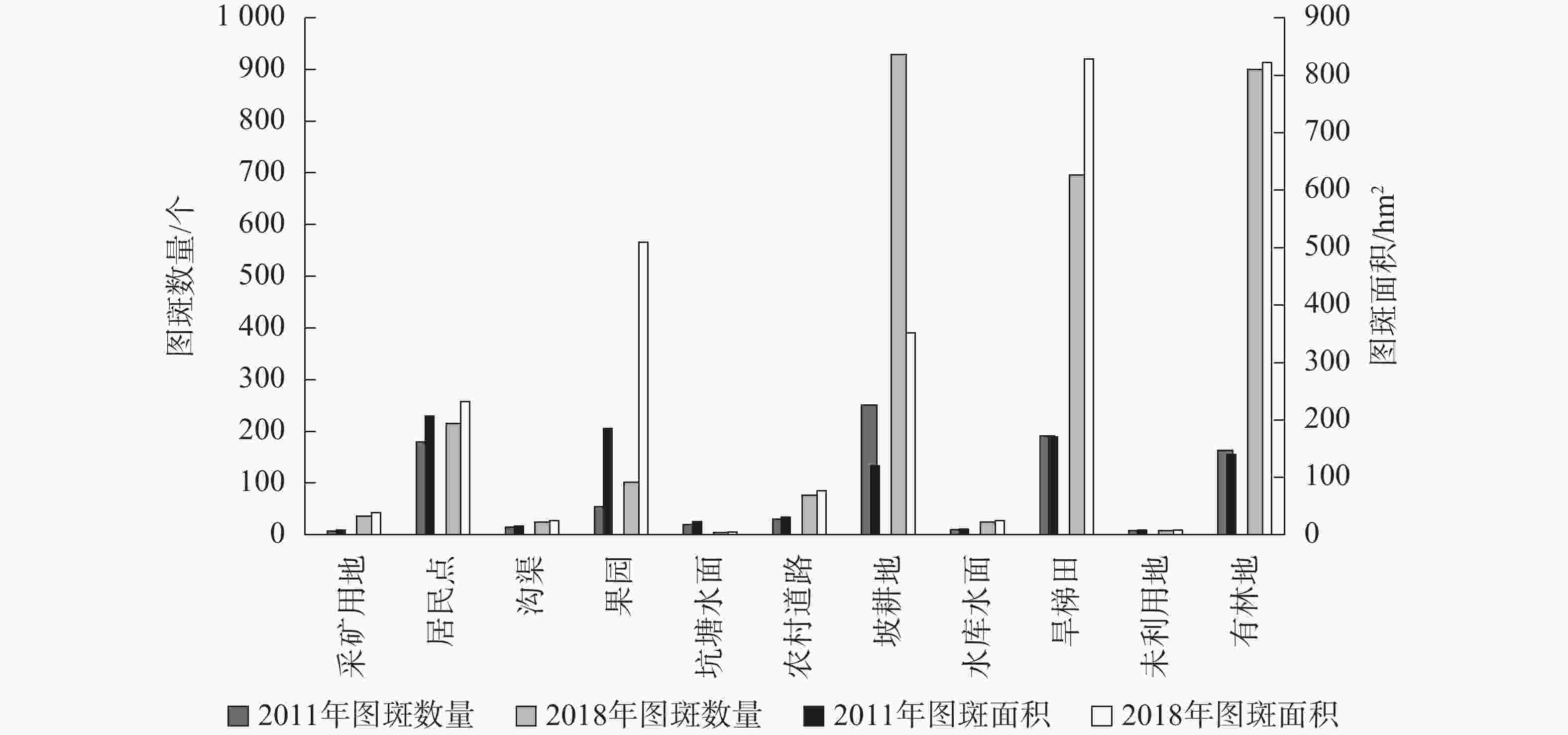
    Figure 1.  Number and area of basic spots and effect spots

    从图斑面积看,2011年基础图斑中坡耕地面积占比最大,达31.89%,其次为有林地(27.66%)、旱梯田(23.86%),村庄居民点及果园面积占比分别为7.39%、3.47%。2018年效果图斑中旱梯田、有林地面积占比相当,分别为28.44%、28.22%,其次为果园面积,占比17.46%,坡耕地面积占比12.06%,村庄居民点占比7.96%(图1)。

    从空间分布看,2011年耕地广泛分布于流域内中东部丘陵区域,在村庄居民点周围呈现大面积、片状、集中特点,且坡耕地和旱梯田交错分布;有林地则主要集中在流域内西部山区,呈大面积集中连片分布;果园较少,零星分布在流域内西部山前过渡带以及村庄周围。2018年耕地在空间上仍广泛分布于流域内中东部丘陵区,但旱梯田优势明显,呈大面积集中片状分布,坡耕地呈块状零散分布于村庄周边;有林地仍集中连片在流域内西部山区;果园分布扩张明显,在流域西部山前过渡带呈集中带状分布,且在村庄周围呈大面积块状聚集(图2)。

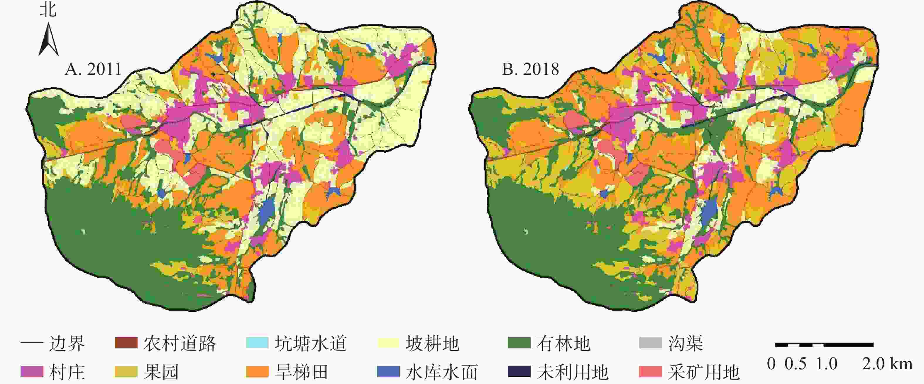
    Figure 2.  Land use in 2011 and 2018

  • 张家村小流域重点工程实施前后图斑变化数量339个,变化面积870.60 hm2。变化方向主要为坡耕地/旱梯田转变为果园,图斑变化数量132个,变化面积364.07 hm2,分别占变化图斑数量和面积的38.94%、41.82%%;其次为坡耕地转变为旱梯田,图斑变化数量77个,变化面积343.77 hm2,分别占变化图斑数量和面积的22.71%、39.49%(表1)。重点工程实施前后坡耕地图斑数量和面积减少最多,图斑数量减少了191个、面积减少了578.59 hm2;果园数量和面积增加最多,共增加156个图斑、407.53 hm2

    实施前后变化方向计数/个面积/hm2 实施前后变化方向计数/个面积/hm2
    村庄居民点—有林地11.06 旱梯田—村庄居民点10.14
    果园—村庄居民点63.36 旱梯田—果园71189.95
    果园—有林地48.69 旱梯田—有林地1020.56
    坡耕地—村庄居民点3213.87 有林地—采矿用地20.78
    坡耕地—果园61174.12 有林地—村庄居民点61.14
    坡耕地—坑塘水面31.22 有林地—果园3455.51
    坡耕地—旱梯田77343.77 有林地—农村道路10.13
    坡耕地—有林地2349.16 有林地—坡耕地53.56
    旱梯田—采矿用地11.80 有林地—旱梯田11.79
    总计339870.60

    Table 1.  Direction of land use change before and after the implementation of the key projects

  • 2011年研究区林草植被面积906.94 hm2,林草植被覆盖率31.13%,以60%~75%的中高覆盖度为主,面积为629.62 hm2;≥75%的高覆盖度次之,面积为181.30 hm2,主要分布在西南部山区。2018年林草植被面积1 331.03 hm2,林草植被覆盖率45.69%,仍以60%~75%的中高覆盖度为主,面积为720.15 hm2;≥75%的高覆盖度次之,面积为494.37 hm2,集中分布在西南部、西北部山区,片状分布在东部(图3)。2011–2018年,项目区林草植被面积增加了424.09 hm2,林草植被覆盖提高率达14.56%。

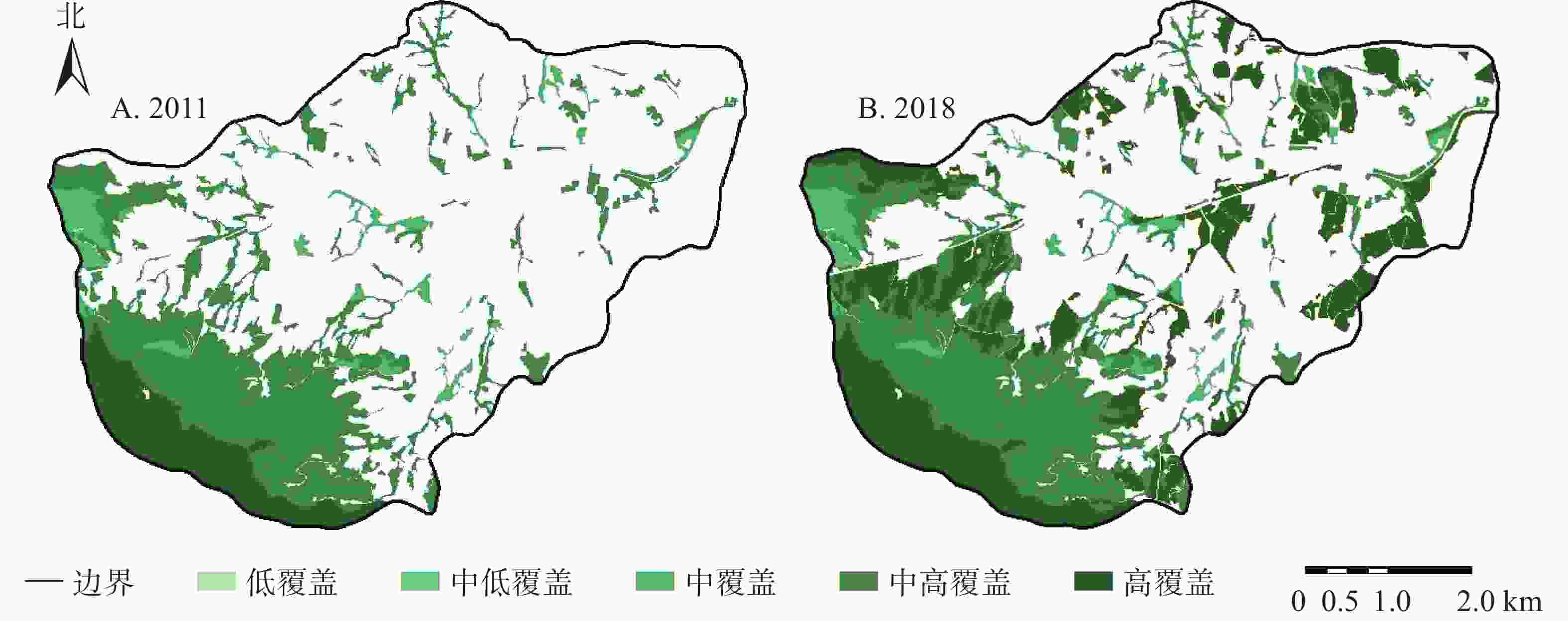
    Figure 3.  Distribution of forest and grass coverage in 2011 and 2018

  • 2011−2018年,林草植被覆盖度发生变化的面积为797.73 hm2(表2),占研究区总面积的27.38%。林草植被转入面积434.84 hm2,占林草植被变化面积的54.51%,主要是经济果林种植面积增加;林草植被转出面积10.75 hm2,占1.3%。各覆盖度等级变化中,高覆盖度增加最多,占林草新增面积73.82%。

    2011年面积/hm22018年面积/hm2
    林草植被面积非林草
    植被面积
    转出面积
    低覆盖中低覆盖中覆盖中高覆盖 高覆盖
    林草植被面积低覆盖 000000.10 0.10
    中低覆盖02.740000.10 0.10
    中覆盖 0052.2339.0701.78 40.85
    中高覆盖000307.78313.078.77321.84
    高覆盖 0000181.3000
    非林草植被面积022.8938.67373.2801571.67434.84
    转入面积 022.8938.67412.36313.0710.75797.73

    Table 2.  Transfer matrix of vegetation coverage change direction of forest and grass coverage from 2011 to 2018

  • 根据2013年验收成果(表3),研究区实施了点—线—面结合的治理措施,面状措施总计1172.48 hm2,其中封禁治理486.62 hm2、经济果林179.00 hm2、水土保持林37.89 hm2、土坎梯田468.97 hm2;点状措施总计28座,包括蓄水池9个、谷坊9座、山塘堰坝10座;线状措施为配套的生产道路8 km。

    项目点状措施线状措旆面状措施水土流失治理
    面积/hm2
    蓄水池/个谷坊/座山塘堰坝/座生产道路/km封禁治理/hm2经济果林/hm2水保林/hm2土坎梯田/hm2
    实施数量99108.00486.62179.0037.89468.971172.48
    现存数量9587.24449.32153.8630.89448.091082.16
    差异  0−4−2−0.76−37.30−25.14−7.00−20.88−90.32
    保存率/%100.0055.5680.0090.5192.3485.9581.5195.55

    Table 3.  Statistical table for preservation condition of soil and water conservation measures

  • 根据2018年水土保持措施调查数据(表3),除蓄水池数量与验收数据一致外,其余水土保持措施面积、数量均有一定程度减少。面状措施现存1082.16 hm2,较验收数据减少90.32 hm2,点状措施谷坊现存5座,山塘堰坝现存8座,分别减少了4座和2座;线状措施生产道路现存7.24 km,减少了0.76 km。

    从水土保持措施保存效果看,除谷坊受损严重,保存率仅为55.56%之外,其余水土保持措施保存率均在80.00%以上。其中蓄水池保存率达100.00%;土坎梯田、封禁治理措施和生产道路措施保存率在90.00%~100.00%;经济果林、水土保持林和山塘堰坝措施保存率为80.00%~90.00%。

    从空间分布看(图4),封禁治理措施集中在西南部,水土保持林措施主要分布在西北部,经济果林措施和土坎梯田措施呈片状分布在王家村西南和西北部、许家沟村北部、龙榜崖村北部、南炉村东南部和西宝兴店村南部,蓄水池零散分布在东部耕地区域。

    Figure 4.  Current distribution of water and soil conservation measures in 2018

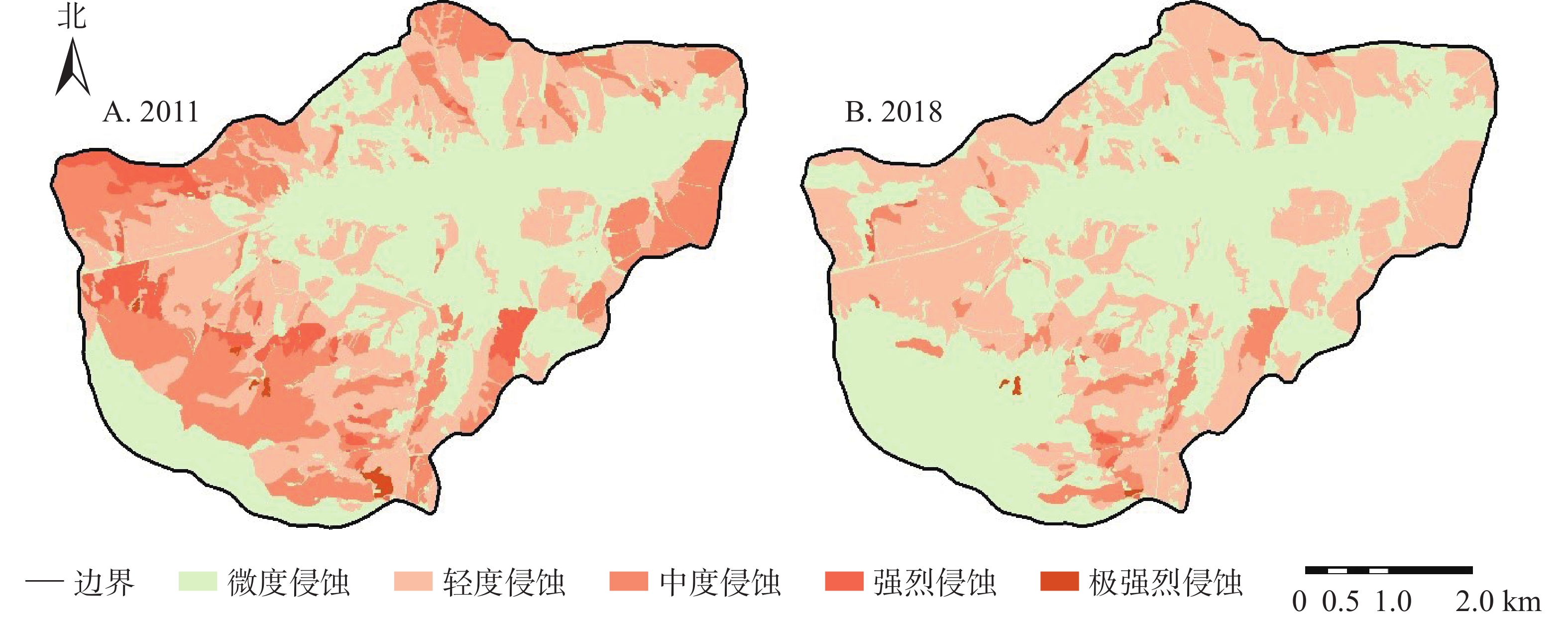
  • 2011年,研究区水土流失面积1724.83 hm2,占总面积59.12%。其中轻度侵蚀908.99 hm2,占水土流失面积52.70%,其次为中度侵蚀678.75 hm2,占39.35%。2018年,水土流失面积1324.44 hm2,占土地利用总面积45.45%。仍以轻度侵蚀为主,面积为1185.53 hm2,占水土流失面积89.51%;中度侵蚀面积125.4 hm2,仅占9.47%(图5)。

    Figure 5.  Soil erosion intensity distribution in 2011 and 2018

    土壤侵蚀强度等级变化面积938.58 hm2,占总面积32.22%。土壤侵蚀强度等级呈降低趋势,侵蚀强度等级降低面积901.58 hm2,占变化面积96.06%;侵蚀强度等级升高面积仅37.00 hm2,占变化总面积3.94%;侵蚀等级面积变化最大的为中度侵蚀,其次为强烈侵蚀和极强烈侵蚀(表4)。

    2011年面积/hm22018年面积/hm2
    微度侵蚀轻度侵蚀中度侵蚀强烈侵蚀极强烈侵蚀转出面积
    微度侵蚀 1151.6135.941.060037.00
    轻度侵蚀 193.79715.21000193.79
    中度侵蚀 243.31340.8994.5600584.19
    强烈侵蚀 0.3192.1224.3910.490116.82
    极强烈侵蚀01.385.3903.026.76
    转入面积 437.4470.3230.8400938.56

    Table 4.  Transfer matrices of soil erosion intensity change

  • 2011−2018年,重点工程实施前后水土流失面积减少了400.39 hm2,水土流失面积消减率达23.21%。评估年治理水土流失面积1082.16 hm2,水土流失治理度76.78%。

    研究区不同措施类型区对水土流失的防控效果不同(表5)。土坎梯田措施区水土流失面积消减率达20.74%。除轻度侵蚀增加外,其余高强度侵蚀等级水土流失面积均减少,主要是原有坡耕地区域实施土坎梯田措施,达到保持水土的效果;经济果林措施区水土流失面积消减率2.80%,土壤侵蚀强度整体呈下降趋势,2018年土壤侵蚀强度等级均为轻度;封禁治理措施区、水土保持林措施区水土流失面积消减率分别为84.82%、78.64%,水土流失防控效果显著。

    措施类型 年份 轻度侵
    蚀/hm2
    中度侵
    蚀/hm2
    强烈侵
    蚀/hm2
    极强烈侵
    蚀/hm2
    水土流失
    面积/hm2
    措施类型 年份 轻度侵
    蚀/hm2
    中度侵
    蚀/hm2
    强烈侵
    蚀/hm2
    极强烈侵
    蚀/hm2
    水土流失
    面积/hm2
    土坎梯田 2011137.69234.6045.090.83418.21封禁治理  201165.98197.63−1.863.90269.37
    2018325.176.3000331.47201817.0520.930.062.8440.88
    增减187.48−228.30−45.09−0.83−86.74增减−8.93−176.70−1.80−1.06−228.49
    经济果林 201151.0729.541.43082.04水土保持林 20118.0921.550029.64
    201879.7400079.7420186.330006.33
    增减28.67−29.54−1.430−2.30增减−1.76−21.5500−23.31

    Table 5.  The statistics of soil and water loss in different measures

  • 根据国家水土保持重点工程信息化监管技术规定,开展实施效果评估的项目原则为竣工验收后1~5 a的重点工程。本研究区张家村小流域于2013年竣工验收,2018年开展重点工程实施效果评估,属竣工验收后5 a项目,水土保持措施中除蓄水池数量保存完好外,其余措施均有一定程度减少。这与竣工验收后年限选取有直接关系,评估年与竣工验收时间间隔越长,对水土保持措施保存率影响越大。为对比分析重点工程实施效果,仍需进一步探索不同区域或同一区域重点工程实施效果评估年时限对水土保持措施的影响。

  • 水土保持基础图斑中坡耕地图斑数量与面积占比最大,效果图斑中则以旱梯田和有林地为主;评估年与基础年相比,图斑变化数量为339个,变化面积870.60 hm2,变化方向主要为坡耕地/旱梯田转变为果园,其次为坡耕地变转为旱梯田;重点工程实施前后坡耕地图斑数量和面积减少最多,果园数量和面积增加最多。

    基础年林草植被面积906.94 hm2,林草覆盖率31.13%;评估年林草植被面积1331.03 hm2,林草覆盖率为45.69%。覆盖度均以中高覆盖(60%~75%)为主,林草覆盖提高率达14.56%。

    水土保持措施现状除蓄水池数量与验收数据一致外,其余水土保持措施面积、数量均有一定程度减少。蓄水池保存率最高,谷坊受损最严重,保存率仅55.56%,其余水土保持措施保存率均在80.00%以上。

    评估年较基础年水土流失面积减少了400.39 hm2,水土流失面积消减率23.21%,水土流失治理度76.78%;不同措施类型区对水土流失防控效果不同,封禁治理措施区、水土保持林措施区水土流失面积消减率分别为84.82%、78.64%,土坎梯田措施水土流失面积消减率达20.74%,经济果林措施区水土流失面积消减率2.80%。

    国家重点工程项目数据库中缺失山塘堰坝、谷坊、蓄水池和生产道路的准确地理位置,这给野外复核工作带来了很大困难。建议国家重点工程相关数据入库时,明确要求提供矢量图件以及各项水土保持措施的精准位置信息,以便精准评估实施效果。

Reference (11)

Catalog

/

DownLoad:  Full-Size Img  PowerPoint
Return
Return