Volume 40 Issue 5
Sep.  2023
Turn off MathJax
Article Contents

WU Genghong, WANG Yiru, LIU Tiedong, GONG Wenfeng, LIN Shiping, CHEN Chong. Evaluation of landscape pattern evolution and spatial configuration of urban park green space in Haikou City based on SEDMs model[J]. Journal of Zhejiang A&F University, 2023, 40(5): 1093-1101. doi: 10.11833/j.issn.2095-0756.20220702
Citation: WU Genghong, WANG Yiru, LIU Tiedong, GONG Wenfeng, LIN Shiping, CHEN Chong. Evaluation of landscape pattern evolution and spatial configuration of urban park green space in Haikou City based on SEDMs model[J]. Journal of Zhejiang A&F University, 2023, 40(5): 1093-1101. doi: 10.11833/j.issn.2095-0756.20220702

Evaluation of landscape pattern evolution and spatial configuration of urban park green space in Haikou City based on SEDMs model

doi: 10.11833/j.issn.2095-0756.20220702
  • Received Date: 2022-12-13
  • Accepted Date: 2023-04-26
  • Rev Recd Date: 2023-04-15
  • Publish Date: 2023-09-26
  •   Objective  This study, with a quantitative portrait of the relationship between the dynamic characteristics of urban park green space system and urban spatial layout, is aimed to provide reference for the rational configuration of urban green space pattern, urban landscape ecological planning and high-quality greening mode in Haikou in the future.   Method  Based on the four periods of remote sensing data and point of interest (POI) data from 2008 to 2020 in Haikou, this study studied the evolution characteristics of green landscape pattern in the park and established State-and-Evolution Detection Models (SEDMs) to explore the spatial configuration relationship between urban environment and park green space through the spatial evaluation of park green space (park availability and accessibility).   Result  The landscape pattern of community parks and historical gardens changed significantly from 2013 to 2017, while other types of parks demonstrated no obvious evolutionary features. The area of urban parks in Haikou continued to grow from 2008 to 2020, with unbalanced development of various types of green spaces and stable growth of parks for residents in the built-up area. Large parks in the eastern and northern parts of the built-up area of Haikou had higher accessibility and wider radiation range. Parks in the western and southern parts were smaller in numbers and radiation range with poor accessibility.   Conclusion  The park green space has evolved from complexity to landscape fragmentation and local regularity, and the landscape spatial structure has developed from discrete discontinuous layout to local centralized layout whereas the general trend of green land vegetation has been featured with a high concentration space and high-quality green pattern. [Ch, 5 fig. 5 tab. 26 ref.]
  • [1] LI Jiahao, LIU Yuguo, ZHAO Ziqing, ZHOU Yining, XU Zihan, CHEN Xinjun, CUI Ming.  Temporal and spatial dynamic monitoring of land desertification and landscape pattern evolution characteristics in the Xiaoluan River Basin . Journal of Zhejiang A&F University, 2023, 40(6): 1322-1332. doi: 10.11833/j.issn.2095-0756.20220731
    [2] XU Hao, LI Wei, LIU Wei, WANG Chengkang.  Spatio-temporal evolution of Nanjing’s urban green space pattern and its influencing factors . Journal of Zhejiang A&F University, 2023, 40(2): 407-416. doi: 10.11833/j.issn.2095-0756.20220332
    [3] CHEN Jin, YOU Weibin, HE Dongjin, HU Xisheng.  Supply and demand relationship and its spatial heterogeneity of urban parks in downtown area of Fuzhou . Journal of Zhejiang A&F University, 2023, 40(6): 1300-1310. doi: 10.11833/j.issn.2095-0756.20230188
    [4] PENG Jianjian, WANG Zeng, ZHANG Yong, LIU Haiying, GU Guangtong, PENG Xinyi, WU Jiasen, YE Zihao, ZHANG Shen, SHANG Shiyu.  Construction of compatible individual tree biomass model of Myrica rubra plantation . Journal of Zhejiang A&F University, 2022, 39(2): 272-279. doi: 10.11833/j.issn.2095-0756.20210272
    [5] LIU Yanfen, YU Kunyong, ZHAO Qiuyue, GAO Yangchi, AI Jingwen, CHEN Fengfei, LIU Jian.  Urban park layout in the main urban area of Fuzhou in the light of service ability . Journal of Zhejiang A&F University, 2021, 38(2): 387-395. doi: 10.11833/j.issn.20950756.20200314
    [6] CAO Jiashuo, DENG Zhengyu, HU Yuandong, WU Yan.  Spatial and temporal evolution and driving forces of the landscape pattern in Shennongjia Forestry District . Journal of Zhejiang A&F University, 2021, 38(1): 155-164. doi: 10.11833/j.issn.2095-0756.20200279
    [7] LU Jianguo, JING Lei.  Biodiversity and characteristics of ground bryophytes in 11 parks of Nanjing . Journal of Zhejiang A&F University, 2019, 36(3): 486-493. doi: 10.11833/j.issn.2095-0756.2019.03.008
    [8] SUN Min, CHEN Jian, LIN Xintao, YANG Shan.  Urban landscape patterns and PM2.5 pollution . Journal of Zhejiang A&F University, 2018, 35(1): 135-144. doi: 10.11833/j.issn.2095-0756.2018.01.018
    [9] WEN Guojing, LIU Yungen, WANG Yan, HOU Lei, WANG Yanxia, GUO Yujing.  Temporal and spatial evolution of landscape patterns and ecological risk in the Puzhehei Lake basin . Journal of Zhejiang A&F University, 2017, 34(6): 1095-1103. doi: 10.11833/j.issn.2095-0756.2017.06.018
    [10] WANG Meiting, SUN Bing, CHEN Lei, LUO Shuixing, CHEN Yong, HUANG Yingfeng, ZHANG Jing, ZHANG Ke.  Scenic beauty for forest plants of typical urban park in Guangzhou . Journal of Zhejiang A&F University, 2017, 34(3): 501-510. doi: 10.11833/j.issn.2095-0756.2017.03.016
    [11] GUO Hui-hui, JIANG Wen-wei, MEI Yan-xia.  Landscape pattern analysis of Yinzhou new city zone based on high spatial resolution aerial photos . Journal of Zhejiang A&F University, 2012, 29(3): 344-351. doi: 10.11833/j.issn.2095-0756.2012.03.005
    [12] SHAO Feng, NING Hui-juan, BAO Zhi-yi, HOU Wei-wei.  Quantified estimates of plant landscapes in urban parks . Journal of Zhejiang A&F University, 2012, 29(3): 359-365.
    [13] WEI Xin-liang, HE Ying.  A correlation study of generation factors for forest landscape effects . Journal of Zhejiang A&F University, 2011, 28(5): 701-705. doi: 10.11833/j.issn.2095-0756.2011.05.003
    [14] ZHANG Li-yang, WEN Guo-sheng, WANG Sheng-jie, LIU Zhao-ling.  Four light-response models to estimate photosynthesis of Phyllostachys pubescens . Journal of Zhejiang A&F University, 2011, 28(2): 188-193. doi: 10.11833/j.issn.2095-0756.2011.02.003
    [15] JIANG Xue-li, WANG Xiao-de, CUI Qing-yun, SHENG Cai-jin.  Plant community diversity of the city parks of Hangzhou . Journal of Zhejiang A&F University, 2011, 28(3): 416-421. doi: 10.11833/j.issn.2095-0756.2011.03.011
    [16] DING Yi-fei.  Analysis and valuation of present park green lands in Zhuji City . Journal of Zhejiang A&F University, 2008, 25(3): 392-396.
    [17] XUAN Gong-qiao.  Application of landscape ecology principle in urban green space system planning . Journal of Zhejiang A&F University, 2007, 24(5): 599-603.
    [18] JIANG Wen-wei, LIU Tong, DING Li-xia, WEN Guo-sheng, ZHANG Wan-rong, ZHONG Tai-lin.  Progress in spatial heterogeneity research in landscape ecology . Journal of Zhejiang A&F University, 2003, 20(3): 311-314.
    [19] HUANG Yue-jin, TANG Jin-chun, SUN Bing-nan.  Application of GIS in agriculture land suitability evaluation . Journal of Zhejiang A&F University, 1999, 16(4): 406-410.
    [20] Li Jian, Ford-Robertson, J B Wattres, M P.  Non-Destructive Sampling for Yield Estimation. . Journal of Zhejiang A&F University, 1995, 12(4): 353-359.
  • [1]
    LI Kehui. Optimization of the Layout of Park Cultural Ecosystem Services under the Background of Park City, Chenghua District, Chengdu[D]. Beijing: Beijing Forestry University, 2021.
    [2]
    BAI Ling, SHAO Wei, JIANG Yafang. Perceptions and attitudes of community residents to national park [J]. Journal of Nanjing Forestry University (Natural Sciences Edition), 2023, 47(2): 205 − 212.
    [3]
    WANG Zilin, LI Zhigang, CHENG Hanbei. The equity of urban park green space accessibility in large Chinese cities: a case study of Wuhan City [J]. Progress in Geography, 2022, 41(4): 621 − 635.
    [4]
    ZHUO Jian, ZHOU Guangkun. Research and implications of flexible regulation of floor-area ratio in the context of urban regeneration: a case study of Tokyo[J]. Urban Planning International, 2023[2023-04-20]. https://doi.org/10.19830/j.upi.2021.420.
    [5]
    LEE Y C, KIM K H. Attitudes of citizens towards urban parks and green spaces for urban sustainability: the case of Gyeongsan City, Republic of Korea [J]. Sustainability, 2015, 7(7): 8240 − 8254.
    [6]
    CHEN Chongxian, LUO Weijing, LI Haiwei, et al. Impact of perception of green space for health promotion on willingness to use parks and actual use among young urban residents[J/OL]. Environmental Research and Public Health, 2020, 17(15): 5560[2022-12-01]. doi:10.3390/ijerph17155560.
    [7]
    LIN B B, FULLER R A, BUSH R, et al. Opportunity or orientation? who uses urban parks and why[J/OL]. PLoS One, 2014, 9(1): e87422[2022-12-01]. doi:10.1371/journal.pone.0087422.
    [8]
    CRISTINA A A, DANIEL D, LUIS Z. Characteristics of urban parks and their relation to user well-being [J]. Landscape and Urban Planning, 2019, 189(9): 27 − 35.
    [9]
    YANG Yi, ZHOU Xiaodan, LIU Xiangyu. Spatial pattern and influencing mechanism of green space use in parkbased on geographical detector [J]. Journal of Shenyang Agricultural University, 2022, 53(2): 157 − 165.
    [10]
    WU Wen, DING Kewei. Optimization strategy for parks and green spaces in Shenyang City: improving the supply quality and accessibility[J/OL]. International Journal of Environmental Research and Public Health, 2022, 19(8): 4443[2022-12-01]. doi:10.3390/ijerph19084443.
    [11]
    FU Hui, FANG Jihua, XU Xiansheng, et al. Evaluation on landscape pattern of haikou urban public spaces [J]. Journal of Northwest Forestry University, 2014, 29(6): 260 − 265.
    [12]
    LEI Jinrui, XIN Xin, SONG Xiqiang, et al. Landscape evaluation and structure analysis of plant community in Haikou City Parks, based on analytic hierarchy process [J]. Journal of Northwest Forestry University, 2016, 31(3): 262 − 268.
    [13]
    CHEN Xinyi, XIE Genzong, ZHANG Jinping. Landscape ecological risk assessment of land use changes in the coastal area of Haikou City in the past 30 years [J]. Acta Ecologica Sinica, 2021, 41(3): 975 − 986.
    [14]
    HAN Shuyao, HE Rongxiao, WANG Fei, et al. Equity evaluation of urban green open space in downtown area of Haikou City [J]. Journal of Chinese Urban Forestry, 2022, 20(6): 133 − 138.
    [15]
    ZHANG Jinping, LIN Dan, ZHOU Xiangli, et al. Spatial accessibility and equality of public medical facilities in rural areas based on the improved 3SFCA: a case of Haikou City [J]. Progress in Geography, 2022, 41(4): 636 − 647.
    [16]
    FU Hui, FU Guang. Land suitability evaluation of urban green space based on GIS in Haikou [J]. Journal of Northwest Forestry University, 2016, 31(4): 291 − 297.
    [17]
    WANG Yiru, ZHU Guopeng, LIU Tiedong. Dynamic change of green space landscape pattern in the built up area of Haikou City based on landscape index analysis [J]. Natural Science Journal of Hainan University, 2021, 39(4): 407 − 413.
    [18]
    QIN Yanli, SHI Peng, HE Wenhong, et al. Influence of urbanization on landscape pattern and ecosystem service value in Xi’an City [J]. Acta Ecologica Sinica, 2020, 40(22): 8239 − 8250.
    [19]
    TIAN Yuhong, JIM C Y, LIU Yiqing. Using a spatial interaction model to assess the accessibility of district parks in Hong Kong[J/OL]. Sustainability, 2017, 9(11): 1924[2022-12-01]. doi: 10.3390/su9111924.
    [20]
    LIU Yanfen, YU Kunyong, ZHAO Qiuyue, et al. Urban park layout in the main urban area of Fuzhou in the light of service ability [J]. Journal of Zhejiang A&F University, 2021, 38(2): 387 − 395.
    [21]
    DONG Xin, CHEN Xiaorui, LI Yanzhong, et al. Ecological environment spatiotemporal variation and driving forces of Giant Panda National Park in Sichuan Province based on geographical detector [J]. Chinese Journal of Ecology, 42(4): 946 − 955.
    [22]
    ZHANG Jian, SHEN Hao. Geo-spatial analysis and optimization strategy of park green space landscape pattern of Garden City: a case study of the central district of Mianyang City Sichuan Province [J]. European Journal of Remote Sensing, 2020, 53(1): 309 − 315.
    [23]
    WEI Xuying, CAI Junhuo, YE Yingcong, et al. Landscape pattern analysis and optimum design of park green space in Nanchang City, China based on GIS [J]. Journal of Applied Ecology, 2018, 29(9): 2852 − 2860.
    [24]
    TIAN Lingwen, LIU Xiangnan, LIU Meiling, et al. State-and-Evolution Detection Models: a framework for continuously monitoring landscape pattern change[J/OL]. IEEE Transactions on Geoscience and Remote Sensing, 2021, 60: 4403114[2022-12-01]. doi:10.1109/TGRS.2021.3088537.
    [25]
    LI Yang. Research on Urban Spatial Morphological Structure Identification and Optimization Based on Multi-source Data in Haikou[D]. Ganzhou: Jiangxi University of Science and Technology, 2019.
    [26]
    LEI Jinrui, CHEN Zongzhu, YANG Oi, et al. GIS-based gradient analysis of urban landscape pattern of Haikou [J]. Journal of Northwest Forestry University, 2017, 32(3): 205 − 210.
  • 加载中
通讯作者: 陈斌, bchen63@163.com
  • 1. 

    沈阳化工大学材料科学与工程学院 沈阳 110142

  1. 本站搜索
  2. 百度学术搜索
  3. 万方数据库搜索
  4. CNKI搜索

Figures(5)  / Tables(6)

Article views(272) PDF downloads(6) Cited by()

Related
Proportional views

Evaluation of landscape pattern evolution and spatial configuration of urban park green space in Haikou City based on SEDMs model

doi: 10.11833/j.issn.2095-0756.20220702

Abstract:   Objective  This study, with a quantitative portrait of the relationship between the dynamic characteristics of urban park green space system and urban spatial layout, is aimed to provide reference for the rational configuration of urban green space pattern, urban landscape ecological planning and high-quality greening mode in Haikou in the future.   Method  Based on the four periods of remote sensing data and point of interest (POI) data from 2008 to 2020 in Haikou, this study studied the evolution characteristics of green landscape pattern in the park and established State-and-Evolution Detection Models (SEDMs) to explore the spatial configuration relationship between urban environment and park green space through the spatial evaluation of park green space (park availability and accessibility).   Result  The landscape pattern of community parks and historical gardens changed significantly from 2013 to 2017, while other types of parks demonstrated no obvious evolutionary features. The area of urban parks in Haikou continued to grow from 2008 to 2020, with unbalanced development of various types of green spaces and stable growth of parks for residents in the built-up area. Large parks in the eastern and northern parts of the built-up area of Haikou had higher accessibility and wider radiation range. Parks in the western and southern parts were smaller in numbers and radiation range with poor accessibility.   Conclusion  The park green space has evolved from complexity to landscape fragmentation and local regularity, and the landscape spatial structure has developed from discrete discontinuous layout to local centralized layout whereas the general trend of green land vegetation has been featured with a high concentration space and high-quality green pattern. [Ch, 5 fig. 5 tab. 26 ref.]

WU Genghong, WANG Yiru, LIU Tiedong, GONG Wenfeng, LIN Shiping, CHEN Chong. Evaluation of landscape pattern evolution and spatial configuration of urban park green space in Haikou City based on SEDMs model[J]. Journal of Zhejiang A&F University, 2023, 40(5): 1093-1101. doi: 10.11833/j.issn.2095-0756.20220702
Citation: WU Genghong, WANG Yiru, LIU Tiedong, GONG Wenfeng, LIN Shiping, CHEN Chong. Evaluation of landscape pattern evolution and spatial configuration of urban park green space in Haikou City based on SEDMs model[J]. Journal of Zhejiang A&F University, 2023, 40(5): 1093-1101. doi: 10.11833/j.issn.2095-0756.20220702
  • 公园绿地景观作为城市景观的重要组成部分[1],不仅在空间维度上反映城市的绿化水平和状态信息,同时,在一定程度上还反映了人们的城市景观审美认知[2]和生态功能的供需水平[3]。然而在城市经济发展的驱动下,城市人口数量急剧膨胀,城市不断向外扩张,导致绿地生态系统被破坏和城市环境及形态结构改变[4]。公园绿地作为人们心理压力与现实负担的缓冲区[56],不仅能够调节城市微气候、缓解温室效应,而且对城市生态改善、居民健康有积极的促进作用[68]。同时,城市里大面积的灰色基础设施中营造结构各异功能互补的城市公园绿地体系,可弱化过度城市化带来的负面影响,对绿地空间格局配置、城市景观生态规划和可持续发展具有重要意义[910]

    目前,海口市绿地景观的研究区域集中于中心城区[11]、城市公园[12]和海岸带[13]等,研究内容侧重于绿地空间公平性评价[1415]、适应性评价[16]、基于景观格局指数[17]的绿地景观质量和生态服务价值评估等,但公园绿地时空演变的研究较少,城市绿地空间配置与绿地格局演变机制研究更少。因此,本研究在海口城市公园演变过程和状态的基础上,基于状态与演变监测模型(State-and-Evolution Detection Models,SEDMs)探究海口城市绿地空间配置,分析城市绿地景观格局时空演变特征,为海口市公园景观的合理规划和建设提供参考。

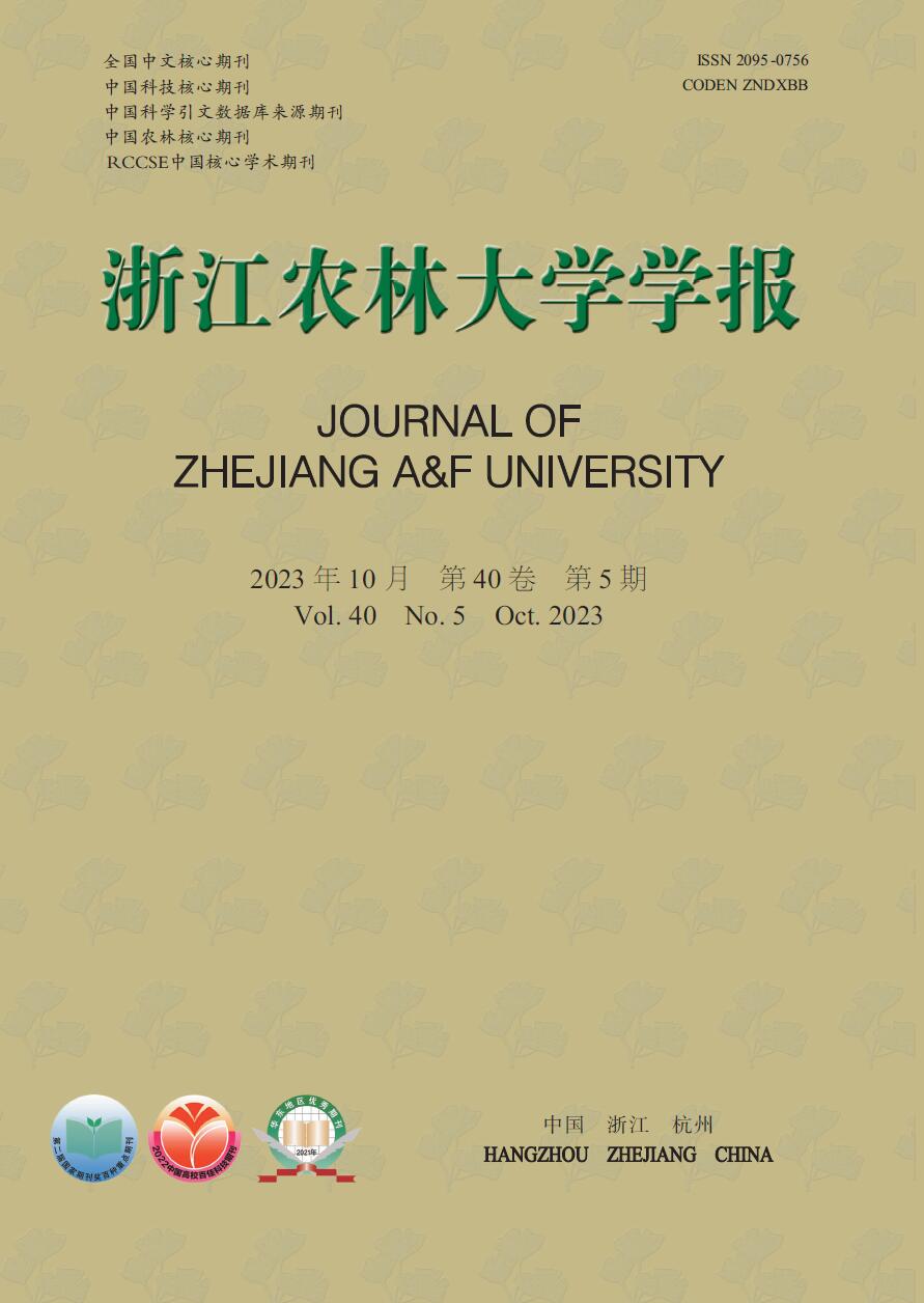
    • 海口市(19°31′~20°04′N,110°07′~110°42′E)地处海南岛最北端,南接定安,北邻琼州海峡,包含秀英区、龙华区、琼山区和美兰区4个区,面积为3 126.82 km2。年均降水量为1 669 mm,年均日照时数为2 000 h以上,年均气温为23.8 ℃,属于热带海洋性季风气候。地形较为平缓,以滨海平原和台地为主。

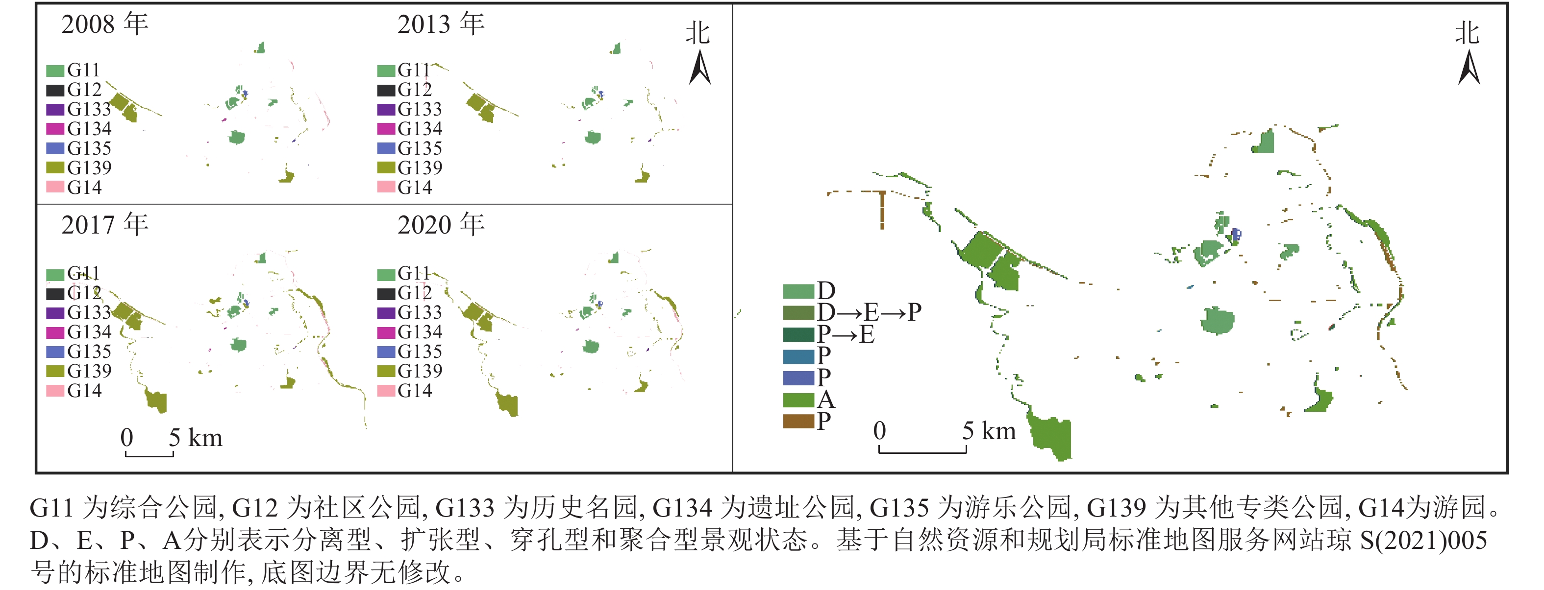
      海口市城市总体范围为椰海大道以北,粤海大道以东和南渡江以西连接北边海岸线,形成闭环式的建成区边界(图1),包含综合公园、专题公园、游园等266个公园绿地,城市公园绿地面积为3 233.63 hm2,其中,建成区的公园绿地总面积为645.90 hm2。北部以世纪公园、白沙门公园、万绿园、五源河湿地公园等与南渡江沿岸周边绿地主体,南部以美舍河凤翔湿地公园、红城湖公园等构成建成区南部绿地景观空间。

      Figure 1.  Boundary range of municipal district in the built-up area of Haikou

    • 遥感数据包括QuickBird影像(2008年11月、2013年11月)、Worldview影像(2013年12月、2017年12月)和Landsat 8 OLI_影像(2020年1月)。在ENVI处理平台完成遥感数据的辐射定标和大气校正,并提取公园绿地。同时收集了海口市矢量路网、小区、公园和路口及2020年的兴趣点(point of interest,POI)数据。

    • 在相关研究[18]的基础上,引入斑块密度(PD)、景观破碎度(SPLIT)、景观蔓延度(CONTAG)、景观分离度(DIVISION)等景观格局指数,定量描述2008—2020年海口市建成区公园绿地景观格局时空演变特征。

    • 基于ArcGIS网络分析模块,对建成区居民到达最邻近目的地的最小距离以及公园服务范围进行定量测算,从而进行可达性配置评价[1920]。利用海口市POI矢量数据模拟海口市建成区环境,综合考虑研究区域基础设施、交通、环境和阻力因素等,评估海口市民到达城市公园的便捷程度,探究演变过程中各城市公园之间的空间连通性。

    • 由于海口市高温多雨的气候条件和错综复杂的热带植被状况,本研究选取11月至翌年3月数据计算NDVI[21],以此时计算的NDVI[22]均值作为全年的NDVI均值,以此评估市民在一定范围内绿地数量的供给水平。利用NDVI对植被区域敏感的特征来反映市民的绿地可获得性水平。

    • SEDMs是用于监测景观格局变化的土地利用模型[2324]。该模型综合了景观模式时空动态分析模型(Spatiotemporal Dynamic Analysis of Landscape Patterns)的特点和景观模式变化类型,可以更准确地评估景观格局过程变化结果和土地利用变化过程。

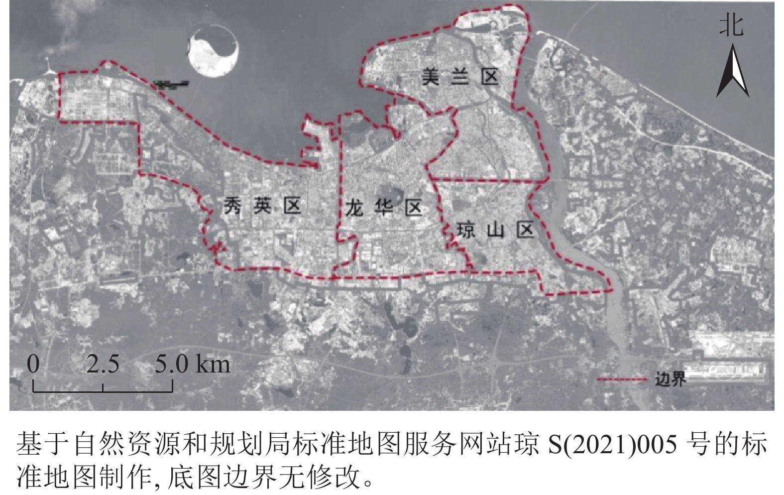
      斑块数(L1)、斑块周长(L2)、斑块面积(L3)和平均斑块分形维度(L4)是描述景观格局时空变化的量化指标,通过识别斑块空间形态差异能有效获取景观破碎化、景观聚合等景观格局演变特征的反馈信息[24]。因此本研究选取以上4个景观指数作为评判指标模拟海口市城市公园绿地的景观格局变化。

      景观状态变化类型分为景观破碎、景观扩张和景观聚合3种形式。SEDMs模型将这3种形式分为6种景观状态作为景观结构演变的评判依据。其中,景观破碎化包括分离型(D)、收缩型(S)和穿孔型(P) 3种景观状态,表示在自然或人工驱动下斑块被分割成更小的、独立的斑块;景观扩张包括创建型(C)和扩张型(E) 2种景观状态,表示景观格局中不同斑块类型斑块面积的增加;景观聚合仅有聚合型(A) 1种景观状态,表示同种类型斑块团聚,斑块连通性和面积增加。将统计的评判指标生成数据集,根据相邻调查时间段4个景观格局指数的差值(∆Li)评判斑块类型。

      式(1)~(3)中:ab表示所选取的任意调查时间段,i表示第i个评判指标,aibi表示在ab调查时间段第i个指标,LaiLbi表示在ab时间段对应的指标值,XaXb则表示从XaXb随机2个时间段斑块数、斑块周长、斑块面积和平均斑块分形维度4个景观格局指数的集合,TS为相邻的调查时间段,S、P、D、E、A、C分别表示6种景观破碎化状态,N表示调查时间段内没有产生格局演变。

    • 表1可见:2008—2020年,7种公园绿地类型的斑块数、斑块面积、斑块周长、平均斑块分形维度的最佳像元为52 m×52 m。根据评判指标的变化表明:①城市综合公园斑块周长在研究期间增长了19.99 m,但平均面积下降了3.73 hm2,其格局呈现破碎化趋势。②社区公园斑块周长从801.59 m骤降至576.93 m,其他评判指标无明显变化,说明其格局逐渐简单规则化,且至少发生过1次景观格局演变。③历史名园斑块平均面积从1.81 hm2降至1.49 hm2,再增长到1.91 hm2;分维数和斑块周长在2013年达到峰值,随后有所降低,斑块形状趋于规则化。④其他专类公园斑块数年均增加8.33个,斑块分形维数数值则从1.06降至1.04,表明海口市建成区专类公园类型趋于单一、简单化。⑤遗址公园斑块面积由3.05 hm2降至1.64 hm2,周长增长1.25倍,表明景观破碎化现象明显。⑥游乐公园与遗址公园相似,呈现景观破碎化趋势。⑦游园的斑块数从35个增加到130个,但斑块面积从1.71 hm2降至0.84 hm2,景观破碎化程度逐渐加深。

      年份综合公园社区公园历史名园
      L1L2L3L4L1L2L3L4L1L2L3L4
      2008736.12208.401.0610.91801.591.0121.81532.151.06
      2013736.12204.981.0710.09595.241.0521.87617.201.20
      2017831.60185.591.0610.99467.841.0321.49401.001.07
      2020832.39228.391.0610.82576.921.0321.91557.691.01

      Table 1.  Change index of green patch structure in Haikou Park from 2008 to 2020

      年份遗址公园游乐公园其他专类公园游园
      L1L2L3L4L1L2L3L4L1L2L3L4L1L2L3L4
      200823.05410.551.07113.79159.051.07448.49656.111.08351.71532.151.06
      201321.67535.461.10115.15198.781.09527.84635.301.071190.94745.671.05
      201731.43526.321.03111.43192.151.071177.96535.411.061260.86601.401.03
      202021.64512.821.08110.64219.781.081226.69582.511.051300.84644.361.04
        说明:L1L2L3L4分别表示斑块数(个)、斑块面积(hm2)、斑块周长(m)、平均斑块分形维度。
    • 2008—2020年海口市建成区各类型城市公园的景观格局总体上呈破碎化趋势,大部分城市公园处于穿孔型(图2),部分城市公园呈现空间聚集化或景观扩张趋势。城市综合公园的景观格局处于分离型(∆L1>0,∆L2<0,∆L4=0),其格局演变过程可能受城市交通或者园林道路建设的影响;社区公园格局发生了多次演变,由分离型转变为扩张型(∆L1=0,∆L2>0,∆L4<0),最后演变为穿孔型(∆L1=0,∆L2<0,∆L3>0,∆L4≥0),很大程度上归因于外界的人为干扰因素,演变过程较为复杂,致使其他性质的用地类型逐渐转变成社会公园建设;历史名园景观格局由原来的穿孔型转变为扩张型,表明海口市园林建设一定程度上促进了历史名园绿地面积的增长;其他专类公园空间格局连通性良好,绿地面积持续增长,景观格局出现了明显的景观聚合现象,处于聚合型(∆L1<0,∆L2≥0,∆L4<0);遗址公园、游乐公园、游园3种公园类型12 a间均未发生明显的景观格局变化,属于穿孔型的景观格局。

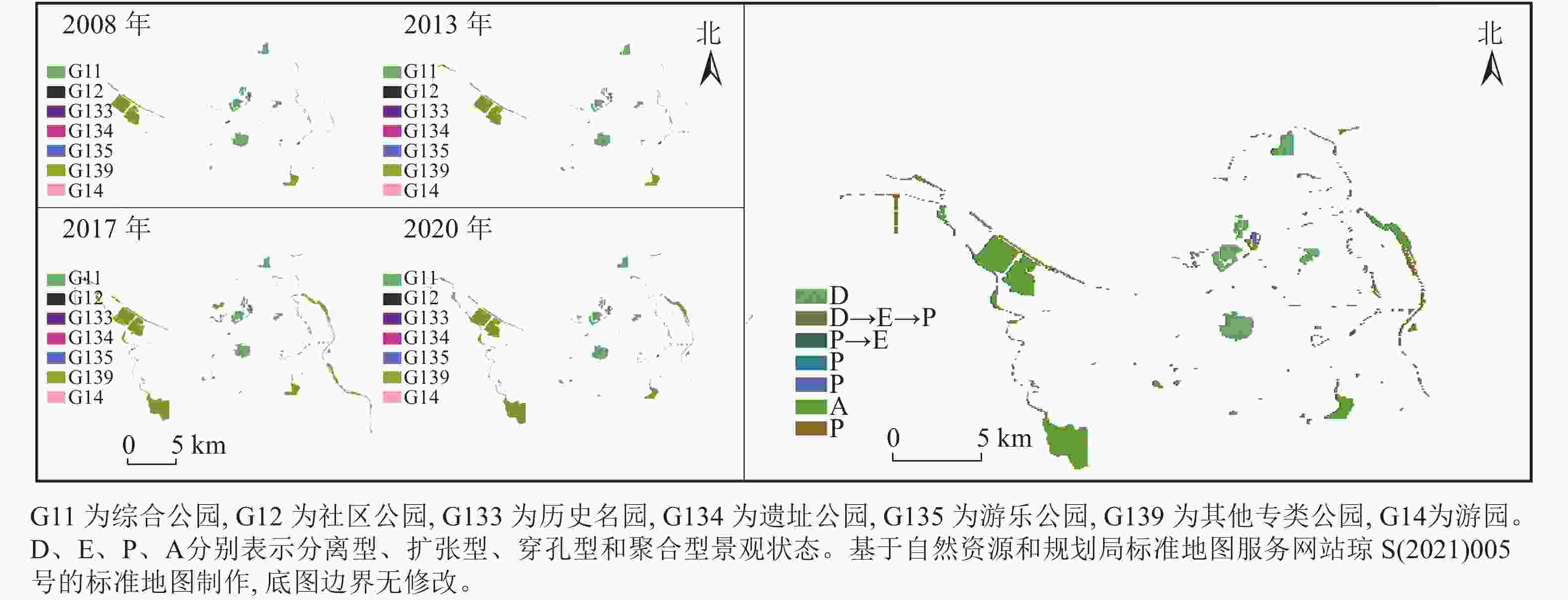
      Figure 2.  Evolution characteristics of landscape pattern in the built-up area of Haikou from 2008 to 2020

    • 表2可知:海口市建成区公园绿地景观破碎度指数和景观蔓延度指数都呈增长趋势,2008—2020年分别增长了1.990和2.143,其中2013年蔓延度最低,而2020年蔓延度最高。表明公园绿地景观异质性在一定程度上增加,但优势斑块(其他专类公园、综合公园)之间具有良好的空间连接度,总体趋势向高集聚方向发展。

      年份斑块密度/(个·hm−2)景观破碎度景观蔓延度/%
      200813.09610.47772.518
      201323.32612.27471.344
      201719.33211.48073.996
      202020.92712.46774.661

      Table 2.  Analysis of the overall spatial fragmentation degree and spread degree of park greenspace in Haikou built-up area from 2008 to 2020

      表3可见:综合公园的景观分离度指数呈先升后降的趋势,2017年为0.991,而2020年下降为0.988。同时,其他专类公园在2013年达0.947,随后有所降低。总体来看,各类型公园的整体集成度较低,空间联系差。由于设计规划策略和政策的影响,在2013年前后,根据《海口市城市绿线管理办法》《海口市城市绿地绿线控制规划(第一批)》等相关规定和园林绿地建设的持续推进,海口市公园绿地建设获得“井喷式”发展,但整体空间分布规律分散程度较高,绿地空间结构单元复杂化,各类型绿地斑块碎片化。2017年,为响应“创建全国文明城市和国家卫生城市”攻坚战,提出了“城市更新”“生态城市”等工作战略部署,园林空间景观品质获得显著成效,绿地空间整体分布由离散式向连续集中式布局发展。2020年综合公园的规范化管理,有效保证了各综合公园之间的空间连续性,但部分专类公园景观分离度仍较高,需进一步加强公园管理措施。

      年份G11G12G133G134G135G139G14
      20080.9671.0001.0000.9991.0000.9390.999
      20130.9731.0001.0001.0001.0000.9470.999
      20170.9911.0001.0001.0001.0000.9230.999
      20200.9881.0001.0001.0001.0000.9321.000
        说明:G11为综合公园,G12为社区公园,G133为历史名园,G134为遗址公园,G135为游乐公园,G139为其他专类公园,G14为游园。

      Table 3.  Spatial separation degree analysis of different types of parks greenspace in the built-up areas of Haikou from 2008 to 2020

    • 将2008—2020年NDVI平均值、园林绿地面积、绿化覆盖率、公园数、公园面积与人均公园绿地面积等进行纵向比较,量化海口市公园绿地的可获得性水平。从表4表5可见:2020年,建成区的绿化覆盖率和人均公园绿地均高于园林城市标准值(绿化覆盖率≥36.0%,人均公园绿地面积≥7.5 m2·人−1),城市园林绿地面积从3 558 hm2增加到8 008 hm2,呈线性增长趋势,近几年海口市建成区人均公园绿地面积为12.3~12.5 m2·人−1,但绿化覆盖率在2015年达到峰值(42.9%)后下降趋势明显。7种类型公园的面积占比发生变化,综合公园、专类公园和游园3种类型公园面积占所有公园面积的比例从2008年的96.55%增加到2020年的97.04%,海口建成区公园建设的重心正在朝这3类公园偏移。同时,海口市建成区NDVI在12 a间发生了剧烈变化。虽然建成区公园面积由628 hm2增加到了1 062 hm2,但海口市建成区绿地植被面积在2013年绿化程度仍处于较低水平,在2017—2020年回升并保持稳步增长,总体趋势逐渐向高绿化水平发展。其中,NDVI高的区域主要分布在万绿园、世纪公园、白沙门公园等处于近郊或者绿地面积较广的区域,NDVI低的区域分布在人民公园、海瑞墓等处于市中心或者城市下垫面硬质面积较多的区域。

      年份城市园
      林绿地
      面积/hm2
      建成区
      绿化覆
      盖率/%
      公园数/
      公园面
      积/hm2
      人均公园
      绿地面积/
      (m2·人−1)
      年度
      NDVI
      20083 55840.517628.009.50.315
      20093 61341.017628.4110.5
      20103 65741.519852.0011.8
      20113 67242.019852.7012.0
      20124 66042.019852.7012.0
      20134 67242.519852.7011.50.169
      20145 74542.719852.7012.5
      20155 80642.919852.7012.8
      20165 70840.619852.7012.1
      20175 73640.819922.7012.30.226
      20186 67641.019922.7012.5
      20197 12841.019922.7012.5
      20208 00841.0211 062.0012.30.261
      园林城市标准≥36.0≥7.5

      Table 4.  Landscaping indicators of Haikou City from 2008 to 2020

      绿地类型2008年2013年2017年2020年
      面积/hm2占比/%面积/hm2占比/%面积/hm2占比/%面积/hm2占比/%
      综合公园  252.8435.57252.8431.82252.8019.27259.1221.19
      社区公园  0.910.100.090.010.990.080.820.07
      历史名园  3.620.503.740.472.980.233.820.31
      遗址公园  6.100.863.340.423.290.333.280.27
      游乐公园  13.901.9615.151.9111.431.0010.640.87
      其他专类公园373.5652.56407.6851.30931.3270.98933.1866.77
      游园    59.858.42100.8614.08108.368.26109.209.08

      Table 5.  Area and proportion of park green space types in Haikou City from 2008 to 2020

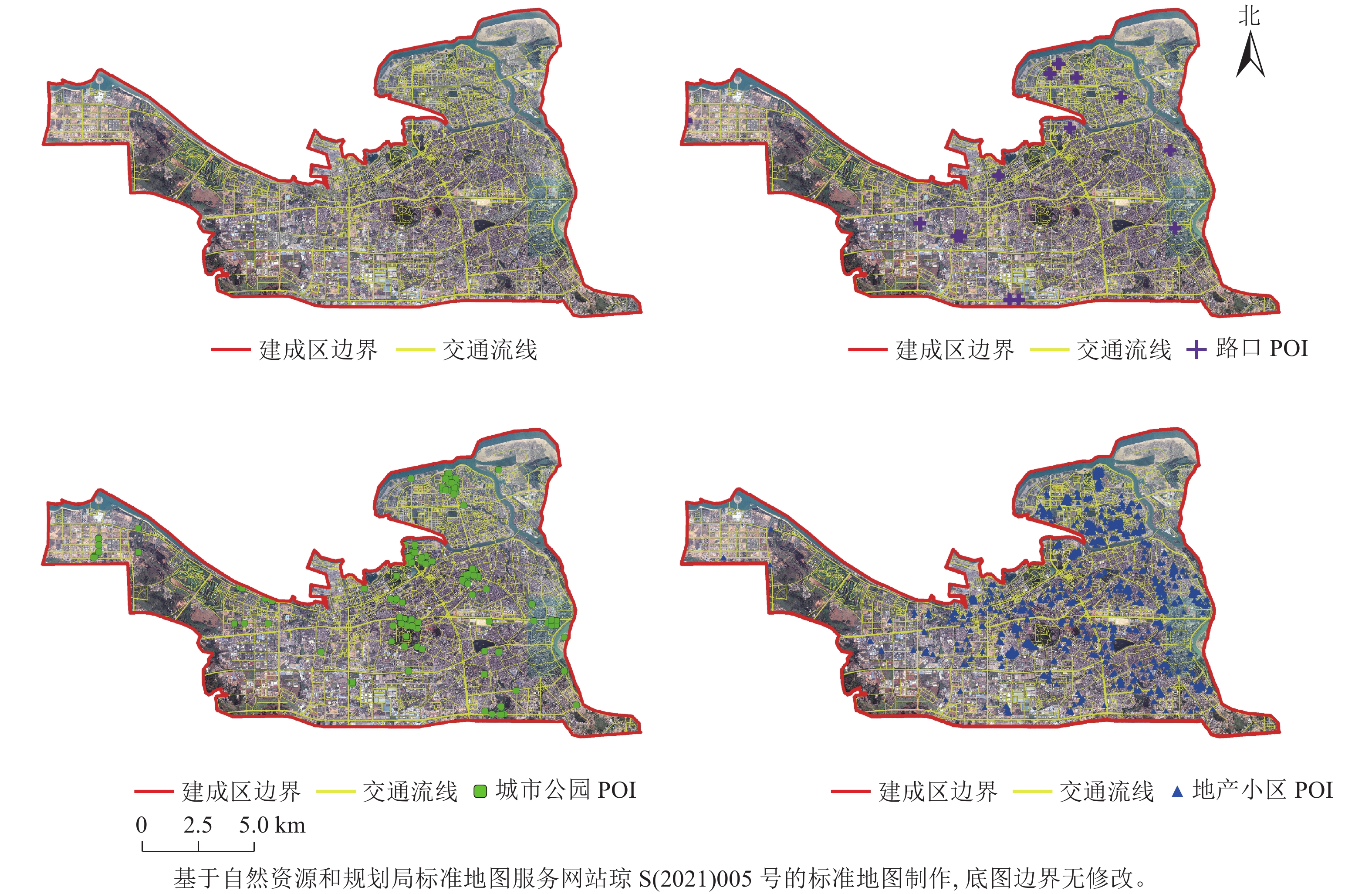
    • 图3为Bigemap全能版地图提供的海口市POI位置。

      Figure 3.  City profile simulated by POI location in the built-up area of Haikou in 2020

      图4所示:以距离为阻抗属性构建服务区,分析居民生活圈与公园设施点之间的网络拓扑关系,对服务区分析求解后获取公园所覆盖的服务范围,并探究小区居民到达附近公园设施点的便捷程度。建成区的公园服务范围主要覆盖了海口市秀英区西海岸、美兰区海甸区域、龙华区北部区域、琼山区东部区域。对于位于其他区域小区位置的居民来说,至少需要行驶1 km以上或步行时长超过15 min才能到达附近的公园。

      Figure 4.  Analysis of green space service area of Haikou City Park in 2020       

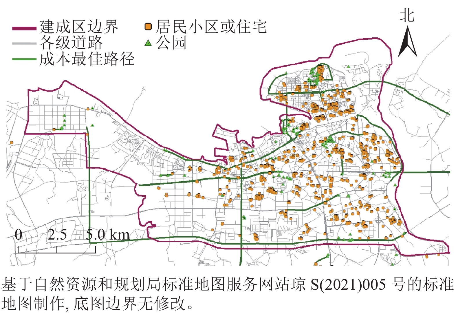
      运用ArcGIS以距离为阻抗属性构建最近设施点分析POI数据(图5),综合考虑学校区域、路口、单行道等不利因素的影响,分析公园(事件点)与小区(设施点)之间的拓扑关系,对设施点分析求解后获取小区到公园的最佳路径。建成区东部尤其是东北部的小区到公园的最佳路径较短,且公园类型多、数量多,代表公园有世纪公园、万绿园、金牛岭公园等。因此它们的辐射范围更广,景观与人居环境空间连通性强,便捷程度较高。建成区西部的小区到公园的最佳路径较长,且公园数量少,主要位于近城区或者处于湿地保护区,景观空间布局简单分散,便捷程度较低。

      Figure 5.  Analysis of the closest facility in the green space of Haikou City Park in 2020

    • 海口市建成区城市公园形成景观破碎化整体空间格局,在局部区域产生集聚式、组团式格局演变,这一结果与李杨[25]、雷金睿等[26]的研究结果一致。本研究推测,道路建设和区域规划的进一步推进是导致海口市建成区景观破碎化的主要原因之一。2017年,《海口市总体规划(空间类2015—2030)》的编制和公园建设,在推进划定生态保护红线和城市开发边界基础上,完善中心城区空间布局的调整,使建成区局部区域保持一定的空间连续性。“孤岛式”的公园体系被逐步淘汰,“空间整体性连续性”是未来城市公园绿地发展的重要目标。因此,要在建设绿地生态体系的同时确保各类型公园绿地均衡发展,平衡好景观价值、服务价值和历史价值之间的关系。

      受研究区域尺度制约,本研究用网格划分景观单元分析海口市建成区整体区域,更有利把控整体环境,也避免小型绿地对整体趋势的干扰。然而从宏观角度分析,仅使用4个年份的遥感数据对小尺度景观格局的趋势分析会存在一定误差,使用长时间多时相高精度的遥感图像,景观格局的演变趋势会更具科学性和严谨性。此外,研究过程中只发现了4种景观状态类型(分离、扩张、聚合、穿孔)和2种演变(分离→扩张→穿孔、穿孔→扩张),可能是其他景观状态在研究区域内极少发生,也可能是其他景观状态类型对公园绿地演变特征不敏感。

      基于此,海口市城市绿地规划应有效针对城市公园绿地景观单元分散和空间连接度差等问题寻求空间布局最优解。首先,对于龙华区和美兰区可达性好的区域,园林建设应突破传统的公园设计范式,保证在城市绿地系统规划和国土空间规划下充分利用好土地资源和公园的景观价值,进行景观提升和空间优化吸引周边居民,丰富居民的人居环境和绿地供给水平;对于琼山区和秀英区中公园可达性较差的区域,应在充分考虑游客和市民短途旅行或漫步休憩需求的基础上,在建成区辖区范围内的适宜区位增设新的城市公园,以保证公园可获得性水平和建成区绿地空间公平。

    • 基于SEDMs模型和遥感影像研究分析,2008—2020年海口市各类园林绿化指标虽然总体保持线性增长,但各类型绿地之间发展不平衡,总体上呈现景观破碎化的趋势。海口市建成区公园绿地景观异质性明显增加,整体空间布局由全局离散复杂化趋于景观破碎化和局部斑块规则化,绿地景观空间结构由离散非连续布局向局部中心集聚式布局发展,总体趋势向高集聚空间模式发展,绿地植被总体趋势向高质量绿化模式发展。

Reference (26)

Catalog

    /

    DownLoad:  Full-Size Img  PowerPoint
    Return
    Return