


-
生态系统服务是指生态系统能够为人类生产生活提供的直接物质资料或间接无形服务等[1]。土地利用变化是改变生态系统最主要的方式[2],随着区域城镇化和工业化的迅速发展,区域内的土地利用类型显著改变,导致生态系统服务功能严重损害[3]。西南高山峡谷区地形复杂、山高坡陡,气候类型独特且雨季较集中,部分区域土壤侵蚀严重,导致生态系统相对脆弱,经济发展缓慢[4]。该区域是生态环境重点保护区,区域内多项生态系统服务功能有所降低[5]。因此,对该区域的生态系统服务进行评估,可以为制定生态保护规划与管理制度等提供参考依据。
生态系统服务评估方法主要有模型综合法、遥感定量法以及基于土地利用数据的单位面积价值当量因子法等[6]。运用较多的模型综合法是基于InVEST、MIMES、NAIS、BTUEM等模型,综合多源数据、调查实验和地理信息系统(GIS)技术等对生态系统服务及其价值进行评估[7−8]。其中InVEST模型因数据需求低、运算高效及高精度等优点[9],能够量化分析多种生态系统服务,绘制区域内空间分布图,有利于揭示生态系统服务的变化情况[10]。产水量定量评估有利于探究区域内水资源的动态变化,对维持水源涵养具有重要的现实意义[11]。在全球碳循环体系中,陆地生态系统中的碳储量占据着重要的地位[12]。不同土地利用类型在碳储量能力上存在显著差异,不同阶段政策影响下的人类活动会引起土地利用变化,从而导致碳储量变化[13]。生境质量是指生态系统提供的适宜个体与种群持续生存和发展的能力,可作为衡量一个地区生态健康状态及可持续状态的关键指标[14]。土壤侵蚀问题是人类生存发展过程中面临的重大环境问题,极大地影响着人类社会的可持续发展[15]。
分析土地利用的历史演变对生态系统服务的影响,有助于预测未来生态系统服务的变化,从而为生态环境保护与未来发展策略提供坚实的理论依据。建立土地利用变化模型是探究土地覆盖变化研究的主要方法。当前应用较广的土地利用模型中,PLUS模型与CA-Markov、FLUS、CLUE-S等模型相比,具有深入挖掘土地覆盖变化驱动因素的能力,能够高效模拟各种地类在未来复杂多变的演化过程[16]。众多学者[17−19]利用PLUS模型对不同发展情景下的土地利用情况进行预测,再耦合InVEST模型对不同地区产水量、碳储量、生境质量等生态系统服务功能指标进行评估,分析不同发展情景下各项指标的变化情况和时空分布特征。以上2种模型耦合能够实现历史和未来时期不同生态系统服务功能指标的评估及对比,反映不同发展情景下区域生态系统服务功能的差异。
为此,本研究利用InVEST模型对西南高山峡谷区2002—2022年的产水量、碳储存、生境质量、土壤保持量等4种生态系统服务进行分析,运用PLUS模型对该地区2032—2052年自然发展情景、耕地保护发展情景、经济优先发展情境下的土地利用类型变化进行预测,再运用InVEST模型对3种情景下的4种生态系统服务进行评估,以期为区域生态环境治理、保护以及推动地区高质量发展提供科学依据。
-
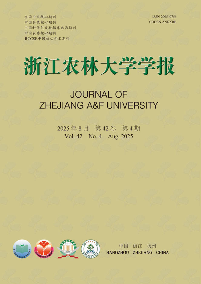
西南高山峡谷区地处四川省、云南省和西藏自治区交界地带(24°58′7.47″~32°51′24.93″N,91°23′48.24″~104°13′43.55″E),包含12个地级市、88个县区,面积为60万km2。该区地处大横断“七脉六江”,海拔为84~7 083 m,地形以山脉和高原为主,分为藏东—川西高山峡谷生态维护水源涵养区(Ⅰ)、藏东南高寒峡谷生态区(Ⅱ)、滇西北高山峡谷生态维护区(Ⅲ)、滇北—川西西南高山峡谷蓄水保护区(Ⅳ)(图1)。气候属于亚热带季风气候和高原山地气候,气温为−3~22 ℃,降水量为296~2 302 mm,雨季较集中,土壤和植被类型丰富。西南高山峡谷区少数民族聚集,种植模式各具特色,规模化种植下集约化程度高,经果林水土流失等问题突出,限制了生态产业的可持续发展。由于特殊地形、地质和气候条件,区域内生态环境脆弱,属于国家生态环境重点保护区域。

Figure 1. Elevation and secondary zoning map of southwest alpine canyon
-
本研究选取地形数据[数字高程模型(DEM)、坡度、公路、河流、道路],经济数据[人口密度、国内生产总值(GDP)],气候数据(降水量、蒸散量)作为影响土地利用变化的驱动因素进行分析。通过地理空间数据云(
https://www.gscloud.cn )下载地区土地利用类型变化驱动因子DEM资料,由DEM处理得到坡度数据;通过全国地理信息资源目录服务下载公路、河流、道路数据;通过中国科学院资源环境科学与数据中心(http://www.resdc.cn/ )下载社会经济数据(人口密度、GDP);通过国家青藏高原科学数据中心(https://data.tpdc.ac.cn/ )下载气候数据(降水量、蒸散量)。 -
根据中国土地覆盖数据集(CLCD),将研究区划分为耕地、林地、草地、水域、雪域、建设用地和未利用地等7类,并通过土地利用转移矩阵定量反映研究区5期(2002、2007、2012、2017、2022年)不同土地利用类型间的相互转换情况。土地利用转移矩阵不仅包含研究初期和末期的土地利用信息,也反映研究时段内各土地利用类型面积转入与转出的详细信息[20]。
-
InVEST模型是量化生态系统服务功能及其经济价值的综合评估模型[10]。本研究选取4种生态系统服务,分别是:①产水量模块。基于水量平衡原理,定义每个栅格单元的产水量为降水量减去蒸散量(含植物蒸腾与地表蒸发)后的剩余水量[11]。②碳储量模块。碳储存模块由四大碳库构成:地上碳库、地下碳库、凋落物碳库、土壤碳库。碳储存总量通过各碳库的平均碳密度与其对应的面积相乘所得[21]。InVEST模型碳储量模块运行需要输入研究区各地类碳密度,通常采取的方式是查阅相关文献与前人的研究成果[22−23]。③生境质量模块。这一模块以土地利用数据为基础,综合考虑外界威胁因子、生境质量适宜度及各地类对威胁因子的敏感度[24]。不同威胁源的权重取值通过相关研究[25−26]和InVEST模型手册获得,在此基础上考虑研究区的特殊性,选用耕地、建设用地和未利用地为威胁因子,并对其权重进行赋值。每种生境对不同威胁源的相对敏感度结合当地实际情况,并参考相关研究[27]对生境适宜度和敏感性进行赋值。④土壤保持量模块。基于通用土壤流失方程,土壤保持总量通过从潜在土壤流失量中减去实际土壤流失量计算得出,实际土壤流失量要考虑植被覆盖因子与土壤保持措施因子的影响[25]。
-
PLUS模型融合了基于土地扩张分析策略(LEAS)的规则挖掘框架,并且采用了多类型随机种子(CARS)的斑块级土地利用模拟模型[28]。PLUS模型运行前使用Kappa系数评估模型的准确性,以2002和2012年实际土地利用数据为基准,利用PLUS模型中的Markow预测得到2022年土地利用数据,与实际的2022年土地利用数据进行对比,验证结果显示Kappa系数为0.80,表明模拟结果具有高准确性。
基于西南高山峡谷区土地、经济、社会发展情况,在PLUS模型中设定自然发展情景、耕地保护发展情景、经济优先发展3种发展情景(2032、2042、2052年)代表研究区未来发展的方向[28]。①自然发展情景。自1999年国家实行退耕还林政策以来,前期耕地向林地大幅度转移,所以预测西南高山峡谷区未来土地利用情况时将耕地向林地的转移概率减少20%[29],不改变其余地类转换。②耕地保护发展情景。耕地是粮食安全的载体,结合研究区情况,在CARS模块中限制耕地向其他土地利用类型转移,并将耕地向建设用地的转移概率减少60%[30−31]。③经济优先发展情景。在CARS模块中限制建设用地向其他地类转移,将耕地、林地、草地转化为建设用地的概率上调20%,建设用地向其他类型转变的概率降低30%[32],以及将未利用地向建设用地转变的概率提高60%[33]。
-
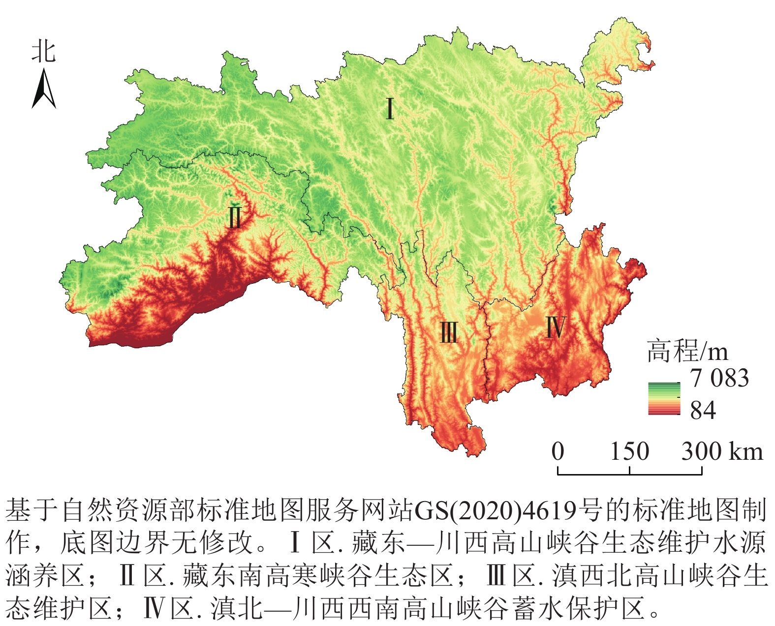
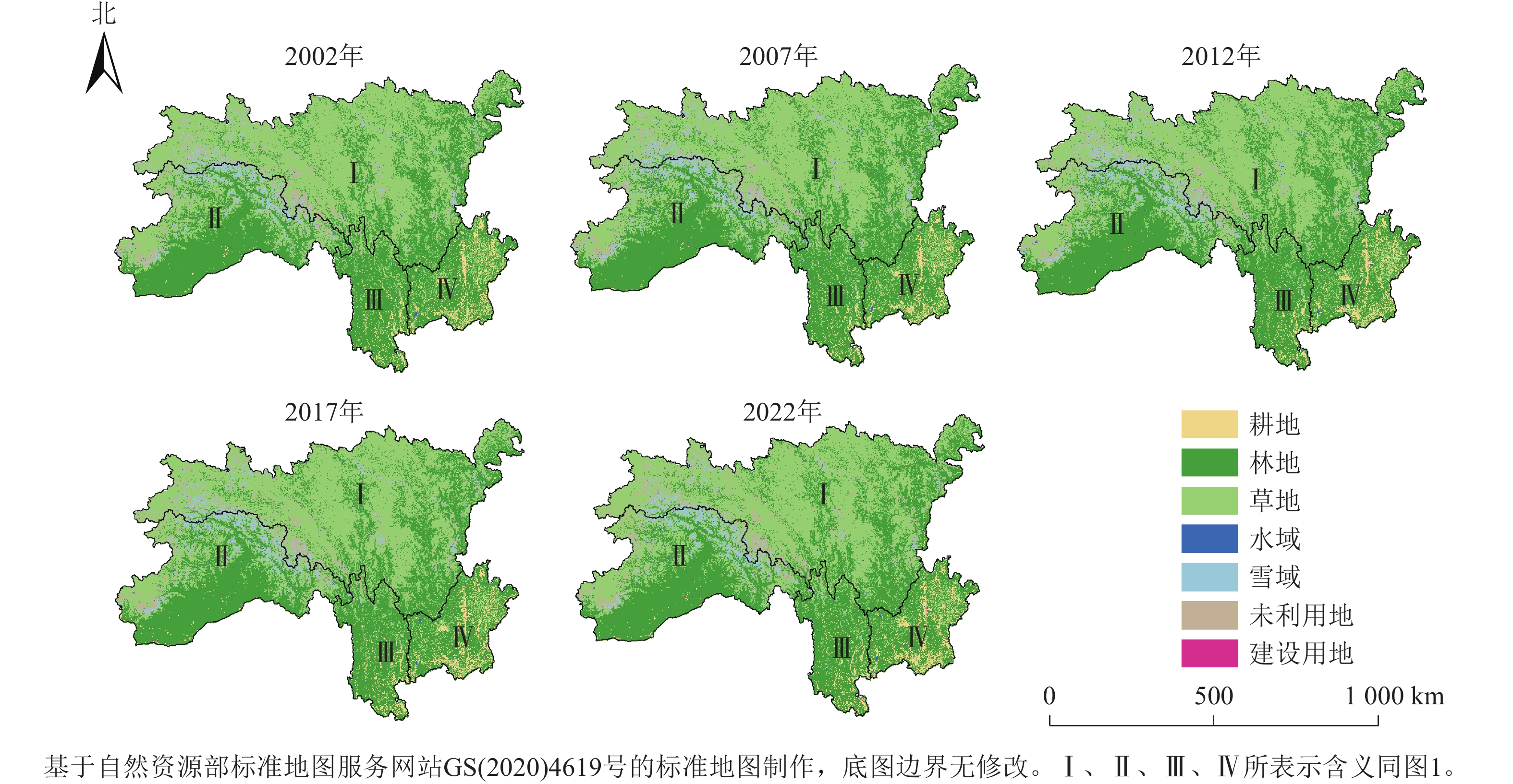
如图2所示:研究区的主要土地利用类型为林地和草地,均占总面积的44%以上,林地主要分布在Ⅱ区南部、Ⅲ区和Ⅳ区,草地主要分布在Ⅱ区北部和Ⅰ区。建设用地面积最少,占总面积的0.03%,分布在地势较为平缓的Ⅲ区和Ⅳ区,所以这2个区域人口较其余区域分布较多。
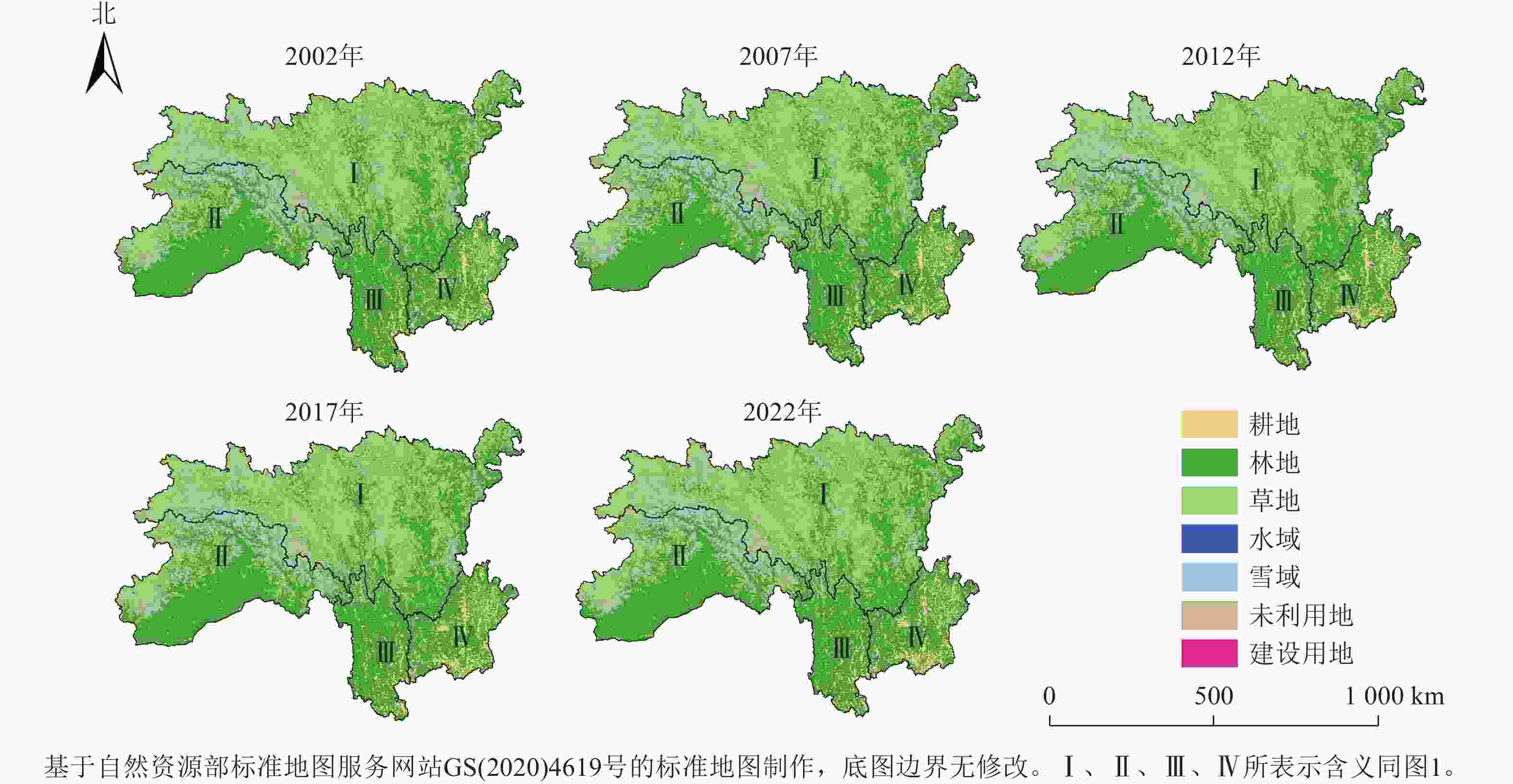
Figure 2. Changes of land use types in southwest alpine canyon region from 2002 to 2022
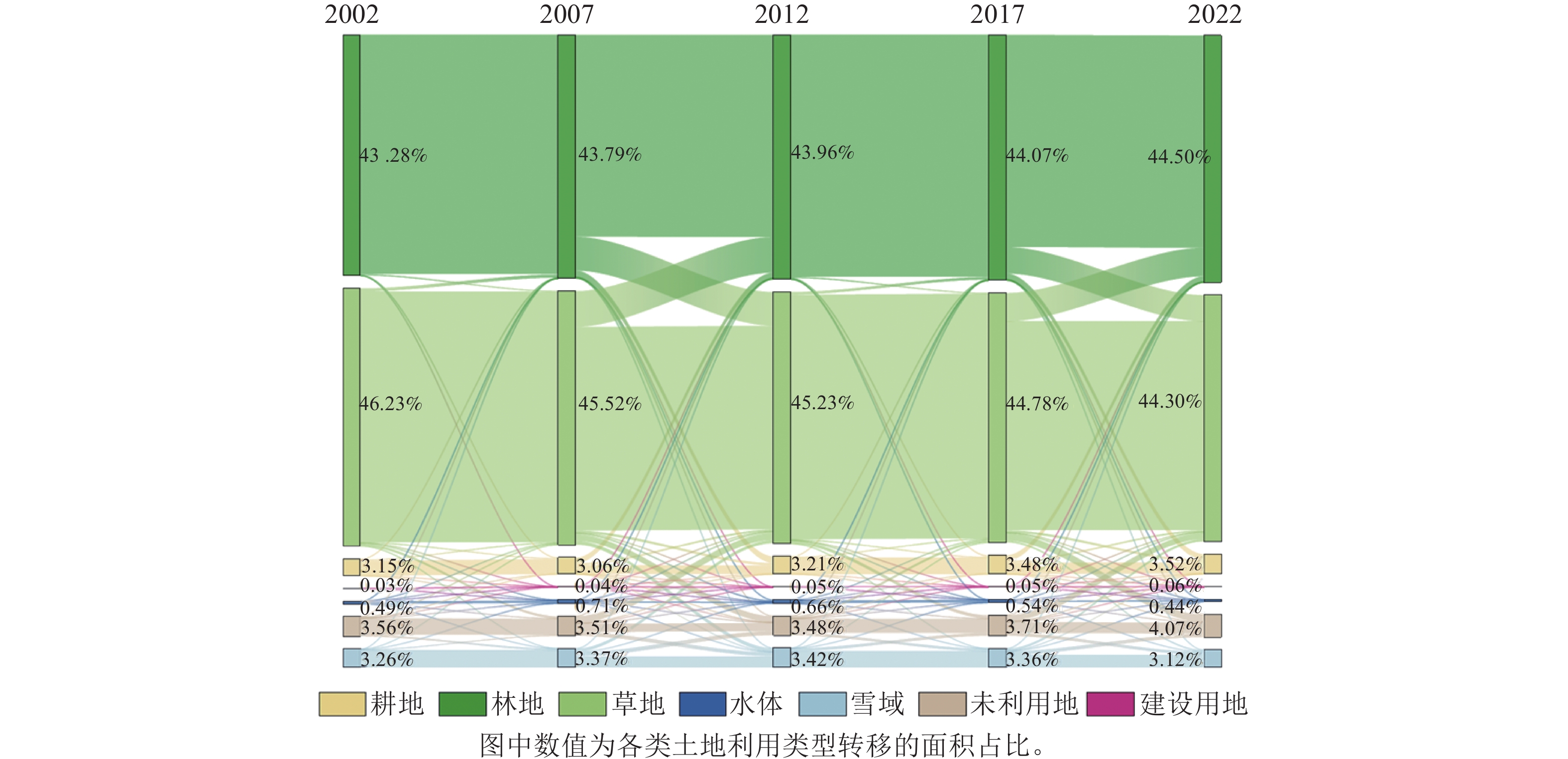
由图3可见:2002—2022年土地利用转移集中在林地、耕地、草地之间,在国家退耕还林政策实施下,林地面积共增加了7 340 km²,耕地、林地的转换变动远大于其他土地利用类型之间的转换,草地的总转出量大于转入量,面积减少11 965 km²。
Figure 3. Land use type change transfer matrix in southwest alpine canyon region from 2002 to 2022
-
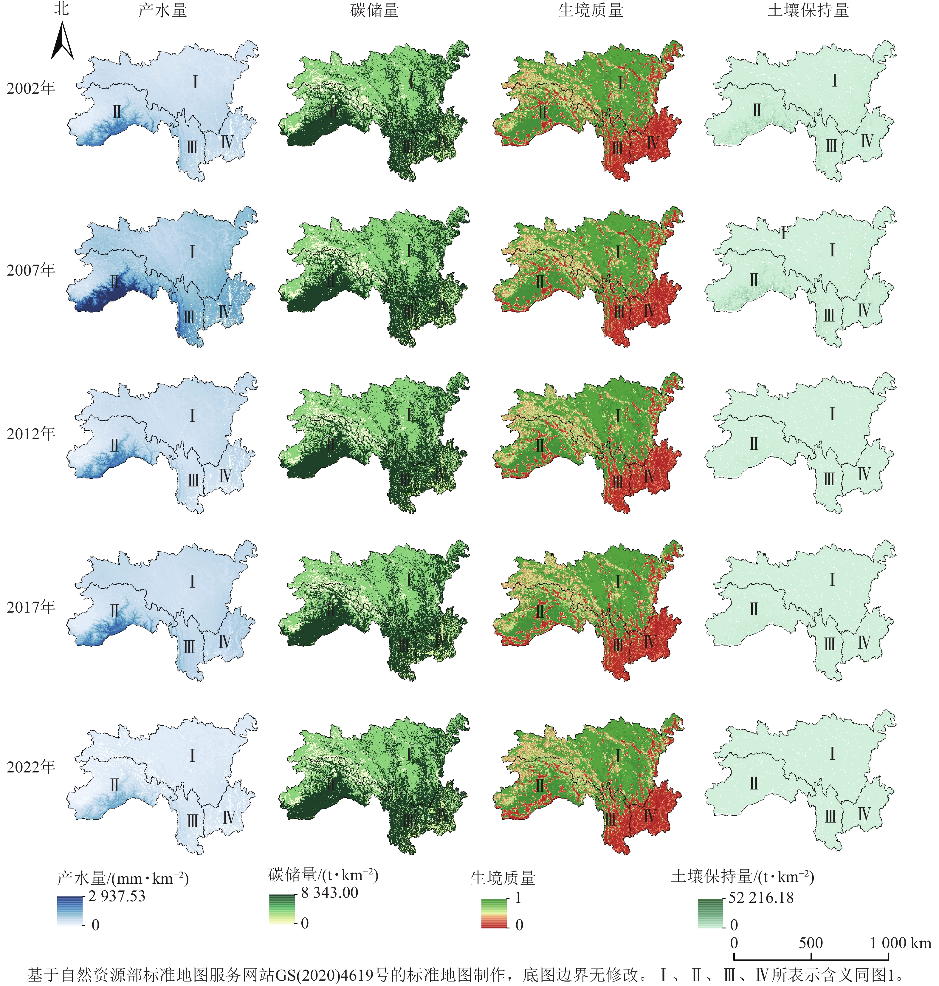
从图4可以看出:2002—2022年,西南高山峡谷区产水量平均值呈先降低后增加再降低的趋势。产水量高的Ⅱ区以林地、水域和雪域为主,地势较高,受人类活动影响较小;产水量低的区域主要分布在Ⅰ区和Ⅳ区,土地类型以草地为主,有相对较多的建设用地和耕地,受人类活动的影响导致产水量较低。碳储量平均值为5 241.55~5 282.36 t·km−2,空间分布上与土地利用类型保持较高的一致性,林地碳储量较高,建设用地和未利用地的碳储量较低。生境质量平均值为0.59~0.62 t·km−2,呈先增加后降低的趋势,生境质量低值和高值区域较多。高生境质量Ⅰ区和Ⅱ区内的草地和林地,对于提升生境质量具有很大的作用。低生境质量的Ⅲ区和Ⅳ区受建设用地和未利用地影响,人类活动频繁,对生境质量产生较大的破坏作用,整体范围内生境质量较低。土壤保持量平均值呈先少量增加后大幅度波动降低的趋势,土壤保持量受降水的影响,降水增加会导致土壤侵蚀强度加剧。在土壤保持量减少最多的2个区域中,Ⅱ区主要受未利用地的影响;Ⅳ区为人口聚集区,建设用地较多,受人类活动干扰,其土壤侵蚀相较其他区域影响更大。
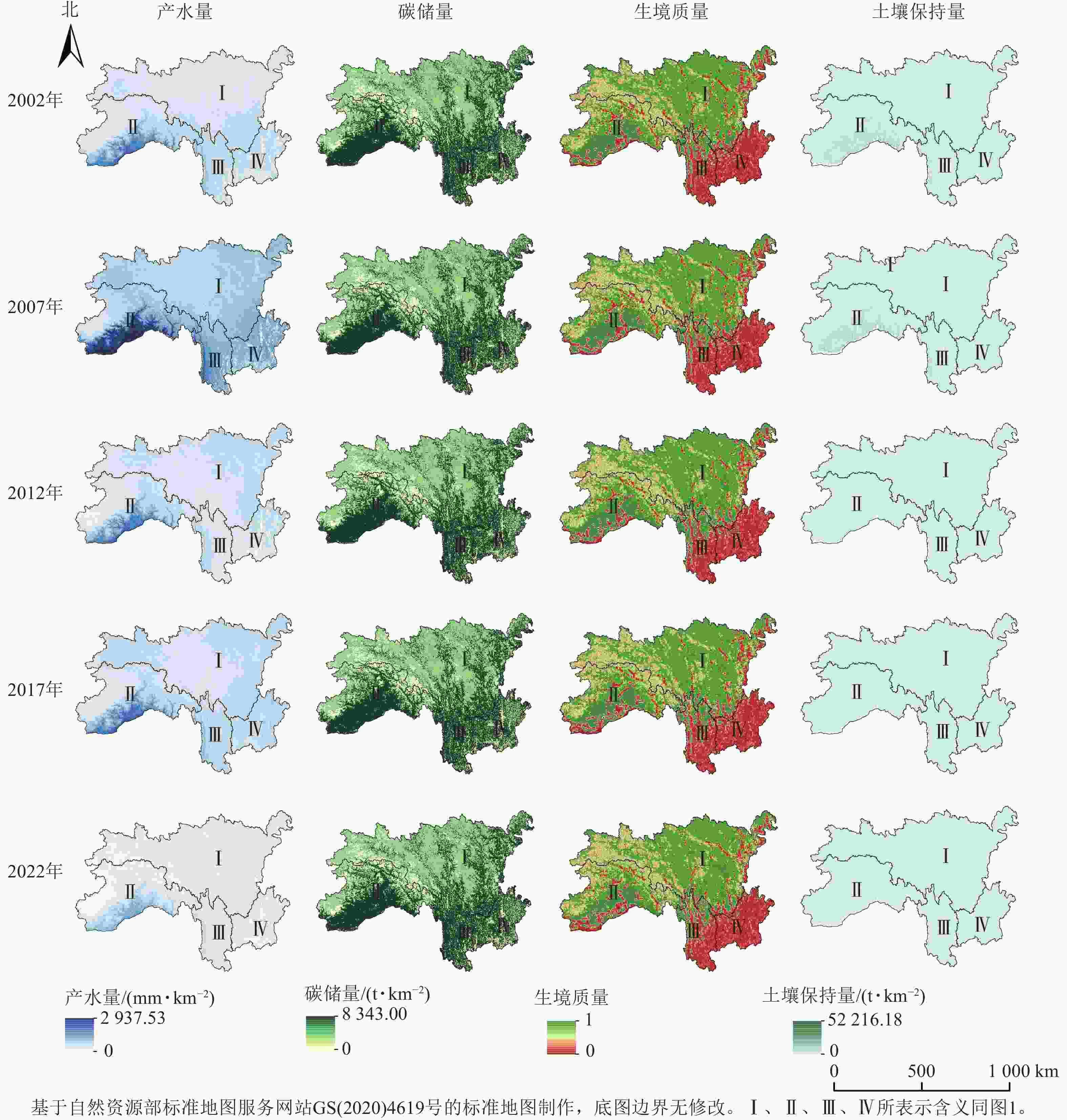
Figure 4. Ecological services in southwest alpine and canyon region from 2002 to 2022
-
从图5可见:在自然发展情景下,耕地、林地、水域、建设用地面积占比增加,其余土地利用类型面积占比降低,其中林地面积增加最多,面积占比增加了0.91%,草地面积占比降低了0.67%。在耕地保护发展情景下,林地、雪域面积占比分别减少了1.06%、0.25%,其余土地利用类型面积占比增加,其中耕地面积占比增加了0.68%,是所有土地利用类型中面积增加最多的类型。在经济优先发展情景下,耕地、林地、水域面积占比增加,草地、雪域面积占比减少,其中林地面积占比增加了0.90%,雪域面积占比减少了0.69%。

Figure 5. Land use types under different scenarios in southwest alpine canyon region from 2032 to 2052
-
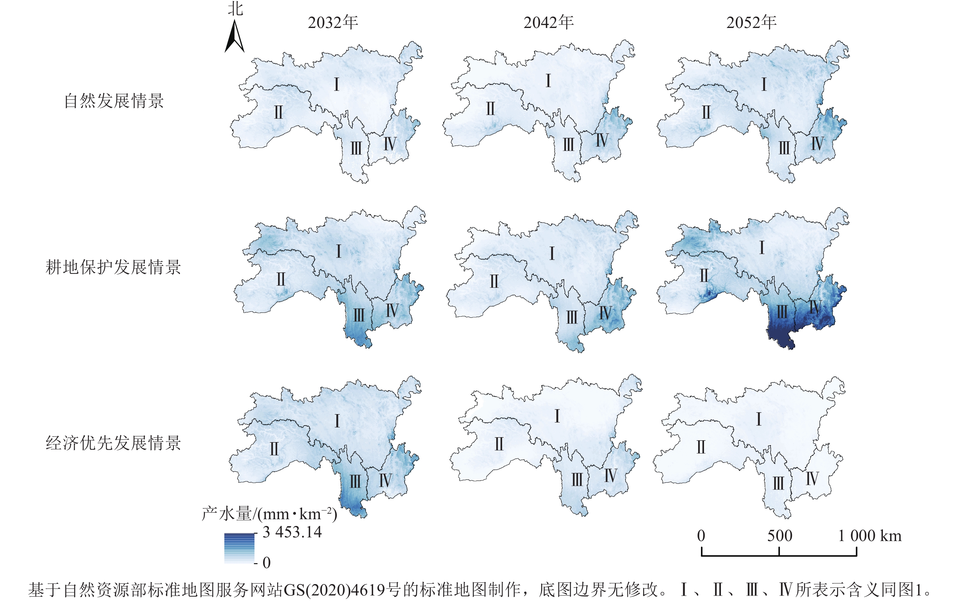
从时间上看,西南高山峡谷区年产水量(图6)在2032、2042、2052年自然发展情景下产水量平均值分别为266.75、244.12、488.12 mm·km−2,呈先降低后增加的趋势。耕地保护发展情景下,产水量平均值逐渐降低,但都高于2022年,2032、2042、2052年产水量平均值分别为625.85、471.53、434.34 mm·km−2。经济优先发展情景下,产水量平均值在2032年时高于2022年,后逐渐降低,2032、2042、2052年产水量平均值分别为635.82、205.30、82.71 mm·km−2。从空间分布上看,3种发展情景下年产水量高值都集中分布在Ⅲ区和Ⅳ区,低值主要分布在Ⅰ区。其中自然发展情景下增长较多的区域在Ⅰ区北部和东部、Ⅳ区北部。耕地保护发展情景下4个区域产水量都有所增加。经济优先发展情景下的产水量降低区域主要在Ⅲ区南部和Ⅳ区东北部。
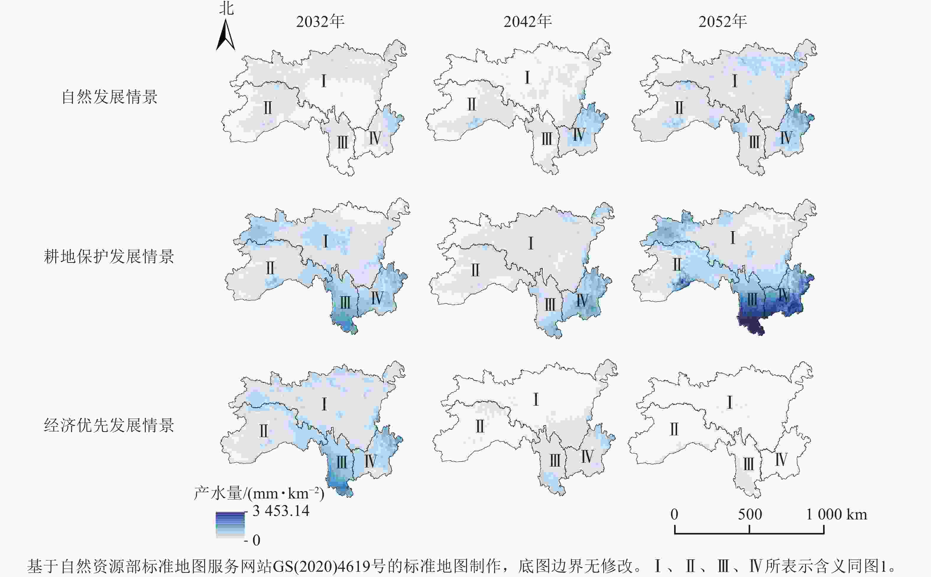
Figure 6. Water production under different scenarios in southwest alpine canyon region from 2032 to 2052
-
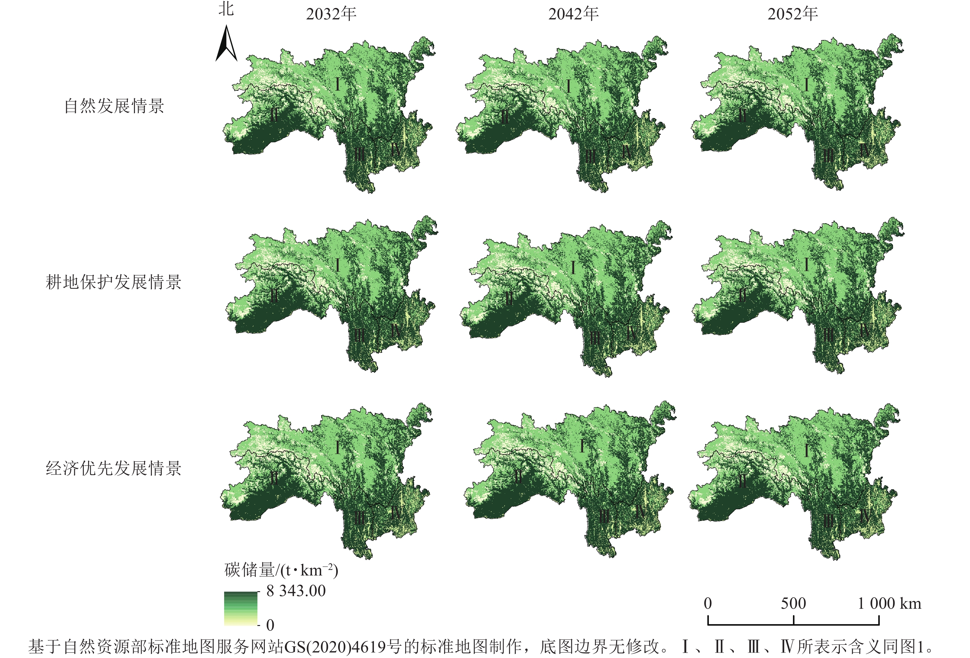
在3种情景下,西南高山峡谷区2032—2052年碳储量平均值都高于2022年(图7)。自然发展情景下碳储量平均值大于5 292.41 t·km−2,并呈逐年增加趋势。耕地保护发展情景下碳储量平均值大于5 317.66 t·km−2,呈先降低后增加的趋势。经济优先发展情景下碳储量平均值少量增加,大于5 339.35 t·km−2,呈逐渐降低的趋势。从整体上看,研究区碳储量高值集中在林地较多的Ⅱ区和Ⅲ区,Ⅰ区主要为草地,碳储量低于以林地为主的其他区域,Ⅳ区虽然林地占比高于其他土地利用类型,但受区域内建设用地和未利用地的影响,碳储量低于Ⅱ区和Ⅲ区。
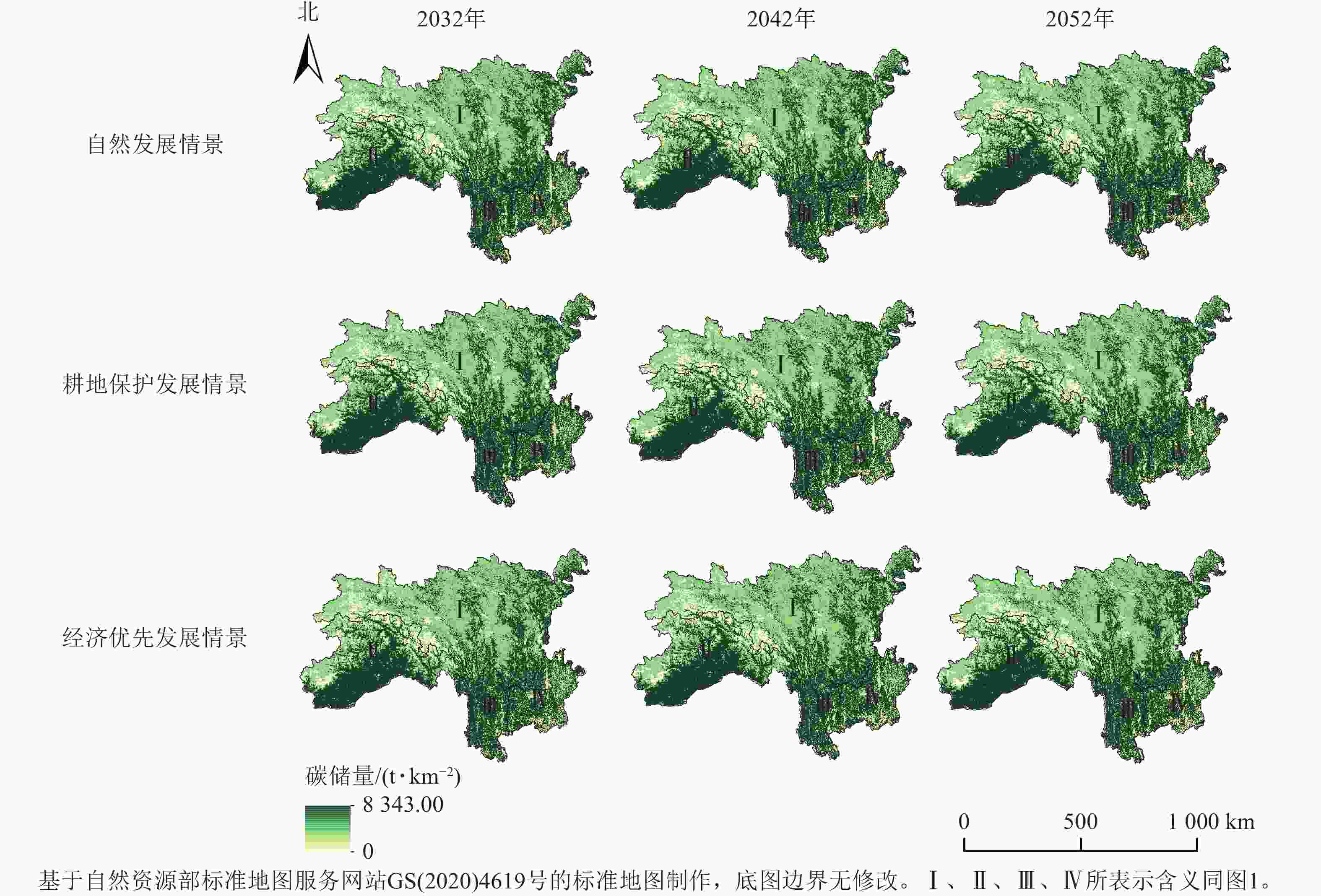
Figure 7. Carbon storage under different scenarios in southwest alpine canyon region from 2032 to 2052
-
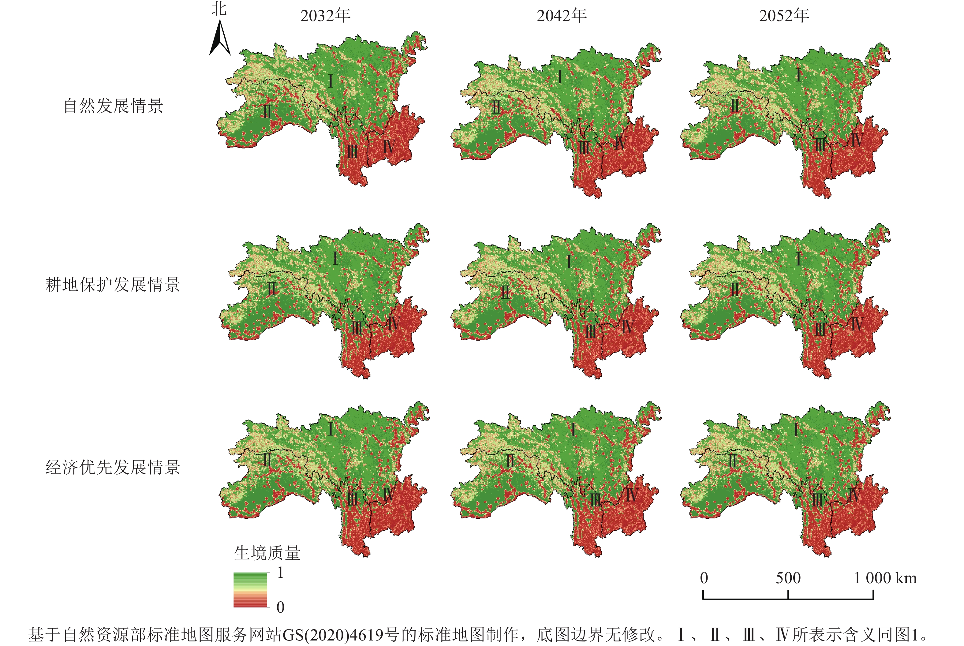
在3种发展情景下西南高山峡谷区生境质量平均值都在0.60以上,且都高于2022年(图8)。自然发展情景和经济优先发展情景下的生境质量平均值趋势大致相同,耕地保护发展情景下生境质量平均值呈先大幅度降低后趋于平缓的趋势。从空间格局上看,3种发展情景下的生境质量与2002—2022年分布基本相同。生境质量较好的区域集中在Ⅰ区,该区域以草地为主,受人类活动影响较小;Ⅲ区和Ⅳ区的生境质量较差,其主要的土地利用类型为建设用地和耕地,该区域地势平缓,受人类活动影响较大。
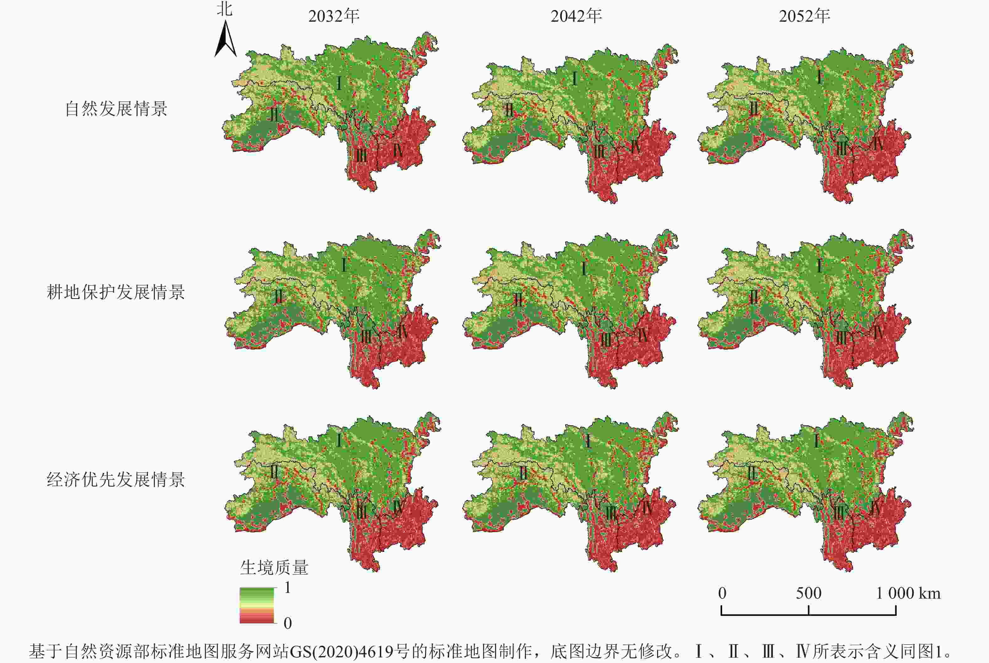
Figure 8. Habitat quality under different scenarios in southwest alpine canyon region from 2032 to 2052
-
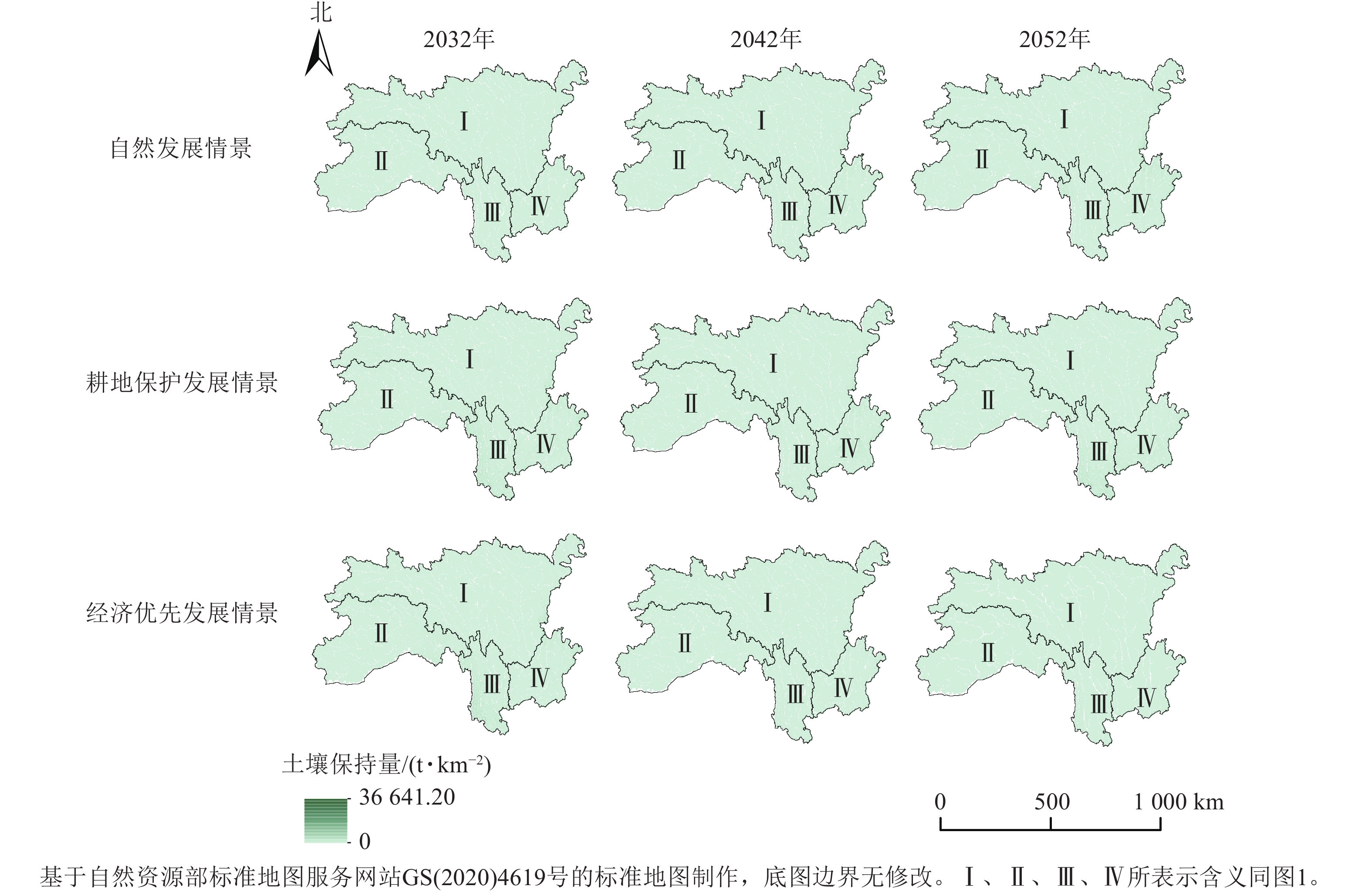
在3种情境下,西南高山峡谷区2032—2052年土壤保持量平均值都高于2022年(图9)。自然发展情景下土壤保持量平均值从2032年的81.58 t·km−2增加至2052年的174.30 t·km−2,前期土壤保持量增加较为平缓。耕地保护发展情景下土壤保持量平均值从2032年的256.09 t·km−2降低至2052年的160.18 t·km−2。经济优先发展情景下土壤保持量平均值从2032年的246.42 t·km−2降低至2052年的60.49 t·km−2,在2042年后逐渐平缓。从空间上看,研究区土壤保持情况较好,但有极端较差情况。土壤保持量最大值分布在Ⅰ区东南部、Ⅲ区西部和南部、Ⅳ区南部,这些地区主要受建设用地和未利用地的影响,土壤保持量高于其他地方。
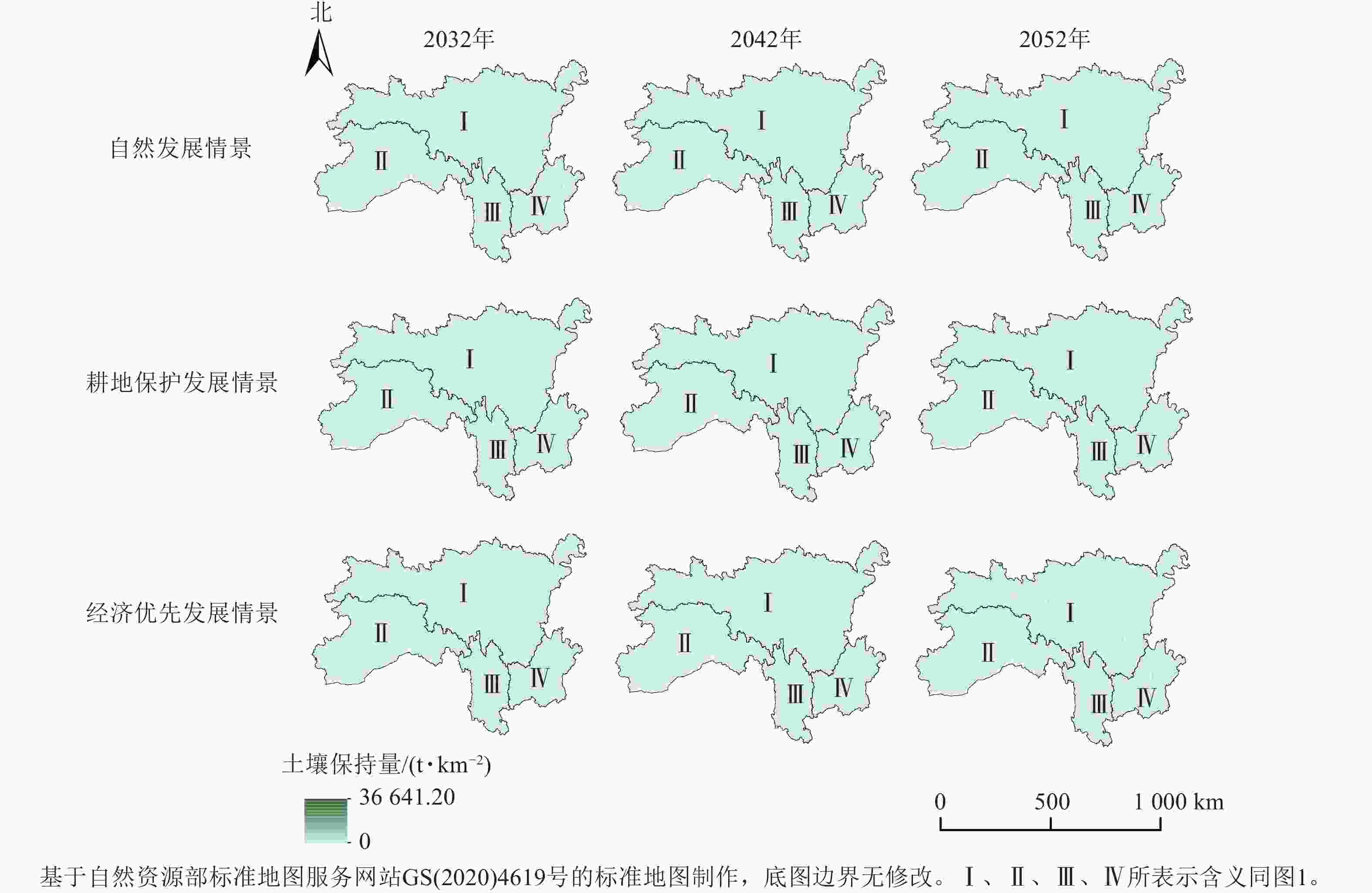
Figure 9. Soil conservation under different scenarios in southwest alpine canyon region from 2032 to 2052
-
本研究表明:西南高山峡谷区土地类型以林地和草地为主,建筑用地面积最少,2022年林地和草地分别占西南高山峡谷区总面积的44.50%、44.30%,建筑用地面积占总面积的0.06%。20 a间土地利用转移集中在林地、耕地和草地之间。
PLUS模型预测下,2032—2052年,自然发展情景下耕地、林地、水域面积增加,草地、雪域、未利用地面积减少;耕地保护发展情景下耕地、草地、水体、未利用地、建设用地面积上升,林地、雪域面积下降;经济优先情景下耕地、林地、水域面积上升,草地、雪域面积下降。
利用InVEST模型计算分析西南高山峡谷区的产水量、碳储量、生境质量和土壤保持量。2002—2022年研究区产水量平均值呈现降低—增加—降低的趋势,高产水量区域集中在Ⅱ区,该区域降水充沛、森林生长繁茂且有大量雪域区域;产水量较低的Ⅲ区和Ⅳ区以耕地和围绕耕地分布的人类活动城镇区为主,这种分布与陈龙[34]的研究结论相似。建设用地中人类活动剧烈,植被覆盖少,不利于有效拦截大量降水,地表蒸散发能力较弱,建设用地的增加一定程度上会引起产水量的增加[35]。本研究区域内碳储量的平均值为5 241.55~
5282.36 t·km−2,呈逐年增加的趋势,其中林地对生态系统碳储量的贡献最明显,这与方精云等[36]的研究结果一致。研究区生境质量主要以高值和低值区域为主,低值区主要分布在建设用地和未利用地较多的Ⅲ区和Ⅳ区,这与冉璇等[37]的研究结论类似。区域内土壤保持量先降低后增加又降低,高值区域集中在多为地表扰动较小的石质山区的Ⅱ区,这部分地区受人类活动影响有限[38];低值区域集中分布在人类活动相对频繁、工农业相对发达的地带,这与谢余初等[39]的研究结果相呼应,土壤保持低值区与滑坡、泥石流灾害多发区或生态高风险区是相对应的。2032—2052年自然发展情景下西南高山峡谷区产水量逐渐增加,高值集中在Ⅲ区和Ⅳ区,碳储量逐渐增加,土壤保持量平均值先减少后增加;耕地保护发展情景在一定程度上保护了农业生产,区域内产水量先减少后增加,碳储量少量增加,土壤保持量平均值逐渐降低;经济优先情景以经济增长为主,忽视资源与环境的保护,在这样的发展情景下,区域内产水量大幅度减少、碳储量少量增加、土壤保持量大幅度减少。3种发展情境下生境质量平均值为0.60左右,期间变化较小,但总体好于2022年。
-
西南高山峡谷区地形复杂,主要以林地和草地为主,建设用地面积最少,土地利用转移主要在林地、耕地和草地之间。碳储量和生境质量整体情况较好,但大量雪域和未利用地也导致产水量、土壤保持量都降低。
Ecosystem service assessment and multi-scenario simulation in southwest alpine canyon region
doi: 10.11833/j.issn.2095-0756.20240590
- Received Date: 2024-10-30
- Accepted Date: 2025-04-01
- Rev Recd Date: 2025-03-28
- Available Online: 2025-06-09
- Publish Date: 2025-08-01
-
Key words:
- ecosystem services /
- land use change /
- InVEST /
- PLUS /
- multi-scenario modeling /
- alpine canyon region
Abstract:
| Citation: | LI Ling, WANG Zhen, WANG Keqin, et al. Ecosystem service assessment and multi-scenario simulation in southwest alpine canyon region[J]. Journal of Zhejiang A&F University, 2025, 42(4): 813−824 doi: 10.11833/j.issn.2095-0756.20240590

|

 DownLoad: