Volume 42 Issue 6
Nov.  2025
Turn off MathJax
Article Contents

DONG Yuanliang, SUN Yingying, PAN Chengcheng, et al. Research on rural landscape zoning in Chuzhou City based on landscape characteristics and ecosystem services[J]. Journal of Zhejiang A&F University, 2025, 42(6): 1285−1295 doi:  10.11833/j.issn.2095-0756.20250167
Citation: DONG Yuanliang, SUN Yingying, PAN Chengcheng, et al. Research on rural landscape zoning in Chuzhou City based on landscape characteristics and ecosystem services[J]. Journal of Zhejiang A&F University, 2025, 42(6): 1285−1295 doi:  10.11833/j.issn.2095-0756.20250167

Research on rural landscape zoning in Chuzhou City based on landscape characteristics and ecosystem services

DOI: 10.11833/j.issn.2095-0756.20250167
  • Received Date: 2025-03-03
  • Accepted Date: 2025-08-06
  • Rev Recd Date: 2025-07-21
  • Available Online: 2025-11-26
  • Publish Date: 2025-12-20
  •   Objective  This study aims to explore methods for rural landscape zoning and regulatory measures that can effectively protect landscape characteristics while continuously providing ecosystem services and promoting sustainable rural development.   Method  Taking Chuzhou City as a case study, 5 categories of landscape feature elements were selected to identify rural landscape feature types and characteristic zones. Further integration with quantitative assessments of ecosystem service functions was conducted to establish rural landscape regulatory zones.   Result  (1) Rural landscapes were classified into 35 landscape feature types and 26 landscape characteristic zones. The total area of cultivated land-dominated zones was approximately 9 634.03 km2, accounting for 80.44% of the study area, serving as the primary rural landscape features in Chuzhou City. (2) The importance of habitat quality, water conservation, carbon sequestration, soil retention, and comprehensive ecosystem services displayed a “one belt and one core” spatial pattern, with central areas forming a zonal extension and concentrated distribution in western Fengyang Mountain region. (3) By integrating landscape characteristics and ecosystem services, rural landscapes in Chuzhou City were divided into 5 regulatory zones: ecological restoration zone, ecological construction zone, ecological rehabilitation zone, ecological maintenance zone, and ecological conservation zone.   Conclusion  The approach integrating landscape characteristic identification and ecosystem service evaluation can effectively preserve the heterogeneity and integrity of rural landscapes, accurately reflect their regional distinctiveness and ecological attributes, and significantly enhance the scientific rationality of zoning regulation. [Ch, 6 fig. 2 tab. 36 ref. ]
  • [1] QIN Huiyan, HU Yueting, HUANG Yingli.  Coupling coordination relationship between ecosystem services and local people’s well-being in Northeast Tiger and Leopard National Park from the perspective of residents’ perception . Journal of Zhejiang A&F University, 2025, 42(5): 1-11. doi: 10.11833/j.issn.2095-0756.20250202
    [2] LI Ling, WANG Zhen, WANG Keqin, LI Yiran, LI Xuanping, MA Yanbo, YANG Jin, FENG Xiaowen.  Ecosystem service assessment and multi-scenario simulation in southwest alpine canyon region . Journal of Zhejiang A&F University, 2025, 42(4): 813-824. doi: 10.11833/j.issn.2095-0756.20240590
    [3] HUANG Xiaojie, DING Jinhua, WANG Daqing.  Spatiotemporal evolution and regulation strategies of ecological risks in green space landscape in the water network area of southern Jiangsu . Journal of Zhejiang A&F University, 2024, 41(6): 1283-1292. doi: 10.11833/j.issn.2095-0756.20240169
    [4] HUANG Yingying, TAN Shizhu, CHEN Qianting, WU Qianqian, SI Nasha, SHEN Yamei, YAN Shaojun.  Rural landscape construction model based on the recognition and evaluation of landscape features . Journal of Zhejiang A&F University, 2022, 39(4): 894-901. doi: 10.11833/j.issn.2095-0756.20210644
    [5] LI Yujie, LU Juan, CHEN Sijia, FU Hui.  On the spatial-temporal patterns and differentiation characteristics of thermal landscape in Haikou City . Journal of Zhejiang A&F University, 2021, 38(4): 712-722. doi: 10.11833/j.issn.2095-0756.20200648
    [6] CUI Yanglin, GAO Xiang, DONG Bin, WEI Huimin.  Landscape ecological risk assessment of county . Journal of Zhejiang A&F University, 2021, 38(3): 541-551. doi: 10.11833/j.issn.2095-0756.20200461
    [7] XIANG Ying, ZHANG Jianguo.  Rural landscape planning of northern Zhejiang based on industrial development orientation . Journal of Zhejiang A&F University, 2020, 37(3): 587-592. doi: 10.11833/j.issn.2095-0756.20190635
    [8] LI Nan, LI Longwei, ZHANG Yinlong, LU Dengsheng, WU Ming.  Changes of ecosystem services value of Hangzhou Bay Coastal Wetland . Journal of Zhejiang A&F University, 2019, 36(1): 118-129. doi: 10.11833/j.issn.2095-0756.2019.01.015
    [9] WEN Guojing, LIU Yungen, WANG Yan, HOU Lei, WANG Yanxia, GUO Yujing.  Temporal and spatial evolution of landscape patterns and ecological risk in the Puzhehei Lake basin . Journal of Zhejiang A&F University, 2017, 34(6): 1095-1103. doi: 10.11833/j.issn.2095-0756.2017.06.018
    [10] AI Jingwen, LIU Jian, YU Kunyong, ZHANG Jinzhao, ZENG Qi, ZHENG Wenying.  Research on contribution rate of plant community characteristics and stand spatial structure to landscape aesthetics quality of forest parks and its influencing factors . Journal of Zhejiang A&F University, 2017, 34(6): 1087-1094. doi: 10.11833/j.issn.2095-0756.2017.06.017
    [11] DUAN Yanbo, LEI Yakai, MA Ge, WU Baojun, TIAN Guohang.  Spatio-temporal dynamics of ecosystem service value in Zhengzhou . Journal of Zhejiang A&F University, 2017, 34(3): 511-519. doi: 10.11833/j.issn.2095-0756.2017.03.017
    [12] ZHANG Yanru, LIANG Lizhuang, NIU Shukui, HAN Hairong.  Ecological landscape quality of Taiyue Mountain in Shanxi . Journal of Zhejiang A&F University, 2016, 33(4): 599-604. doi: 10.11833/j.issn.2095-0756.2016.04.007
    [13] YAN Jun, ZHA Yangsheng, LIANG Huilin.  Mountain park landscape space site selection based on mountain morphological characteristics . Journal of Zhejiang A&F University, 2015, 32(6): 927-932. doi: 10.11833/j.issn.2095-0756.2015.06.016
    [14] CAI Xia, WANG Zu-hua, CHEN Li-juan.  Zoning with spatial division of forest ecosystem services in Chun’an County,Zhejiang Province . Journal of Zhejiang A&F University, 2011, 28(5): 727-734. doi: 10.11833/j.issn.2095-0756.2011.05.007
    [15] MA Jun, WEI Xin-liang, YOU Jian-lin, XU Xiao-jun.  Tree species selection for an ecological landscape forest at Qingshan Lake,Zhejiang Province . Journal of Zhejiang A&F University, 2008, 25(5): 578-583.
    [16] HE Ying,  WEI Xin-liang,  CAI Xia,  LI Ke-zhui,  WANG Zhen.  Quantitative analysis of community structure in ecological landscape forests . Journal of Zhejiang A&F University, 2007, 24(6): 711-718.
    [17] SONG Yu, JIANG Hong, YUShu-quan, ZHOUGuo-mo.  Landscape ecological analysis of soil erosion . Journal of Zhejiang A&F University, 2007, 24(3): 342-349.
    [18] JIANG Wen-wei, LIU Tong, DING Li-xia, WEN Guo-sheng, ZHANG Wan-rong, ZHONG Tai-lin.  Progress in spatial heterogeneity research in landscape ecology . Journal of Zhejiang A&F University, 2003, 20(3): 311-314.
    [19] Ma Junshan.  Research of Reservoir Landscape Design. . Journal of Zhejiang A&F University, 1997, 14(2): 178-181.
    [20] Ma Junshan.  Scenery Feature and LandseaPe Design of the Xianhua Peak Forest. . Journal of Zhejiang A&F University, 1996, 13(1): 82-87.
  • [1]
    WANG Yuncai, LIU Binyi. Discussions on rural land-scape and rural landscape planning in China [J]. Chinese Landscape Architecture, 2003, 19(1): 55−58.
    [2]
    LIU Chonggang, SUN Wei, CAO Yuhong, et al. The evolution measurement of ecological service function in rural areas: a case study of Nanjing [J]. Journal of Natural Resources, 2020, 35(5): 1098−1108.
    [3]
    WU Yunong, ZHOU Jianhua. Research perspectives on the character assessment and management of rural landscapes under the “human-landscape relationship” model [J]. Chinese Landscape Architecture, 2024, 40(9): 64−69.
    [4]
    CHEN Xiaoqin, KANG Binyue, LI Meiyang, et al. Identification of priority areas for territorial ecological conservation and restoration based on ecological networks: a case study of Tianjin City, China[J/OL]. Ecological Indicators, 2023, 146: 109809[2025-02-15]. DOI: 10.1016/j.ecolind.2022.109809.
    [5]
    XU Shengli. Study on rural land use change and ecosystem services value in Jiangxi Province [J]. Chinese Journal of Agricultural Resources and Regional Planning, 2018, 39(7): 113−120.
    [6]
    TORRES A, JAEGER J A G, ALONSO J C. Multi-scale mismatches between urban sprawl and landscape fragmentation create windows of opportunity for conservation development [J]. Landscape Ecology, 2016, 31(10): 2291−2305.
    [7]
    ZHAO Ye, GAO Chi. Review and enlightenment of the British National Park landscape character assessment system [J]. Chinese Landscape Architecture, 2018, 34(7): 29−35.
    [8]
    BUTLER A, BERGLUND U. Landscape character assessment as an approach to understanding public interests within the European landscape convention [J]. Landscape Research, 2014, 39(3): 219−236.
    [9]
    WU Xue, CHEN Rong, ZHANG Yunlu. Recognition and assessment method of rural landscape characters for multi-type and multi-scale collaborative transmission: taking the Horqin Right Front Banner, Inner Mongolia of Northern China as an example [J]. Journal of Beijing Forestry University, 2022, 44(11): 111−121.
    [10]
    LI Zijian, ZHAO Jun, WU Xuefei. Identification and protection of traditional village landscape features from the perspective of human-land relationship: taking southwestern Hubei as an example [J]. Territory & Natural Resources Study, 2024(2): 52−58.
    [11]
    LI Zhenpeng, LIU Liming, XIE Hualin. Methodology of rural landscape classification: a case study in Baijiatuan Village, Haidian District, Beijing [J]. Resources Science, 2005, 27(2): 167−173.
    [12]
    ZHANG Jun, JIN Xiaojun, YANG Fan, et al. Study on the classification distribution and evaluation index system of Zhejiang rural landscape resources [J]. Urbanism and Architecture, 2022, 19(19): 163−168, 182.
    [13]
    CUI Monan, XIAO He, ZHANG Qian, et al. Research on the classification and mapping of rural landscape in the Taihang piedmont in Hebei Province: take three villages in Sanling Township of Handan City as an example [J]. Tianjin Agricultural Sciences, 2019, 25(3): 68−74.
    [14]
    CHEN Zhaofang, WANG Yuncai. Spatial ecological wisdom for identification and cognition of rural landscape units: a case study of Nanjing Paifang rural community [J]. Landscape Architecture, 2022, 29(7): 30−36.
    [15]
    YOU Guixuan, WANG Peiran, CAO Jiashuo, et al. Analysis of spatial-temporal evolution and coupling effects of land use and ecosystem services in a resource-based city [J]. Journal of Southwest Forestry University (Natural Sciences), 2025, 45(1): 117−127.
    [16]
    FENG Zhao, PENG Jian, WU Jiansheng. Ecosystem service bundles based approach to exploring the trajectories of ecosystem service spatiotemporal change: a case study of Shenzhen City [J]. Acta Ecologica Sinica, 2020, 40(8): 2545−2554.
    [17]
    PANG Caiyan, WEN Qi, DING Jinmei, et al. Ecosystem services and their trade-offs and synergies in the upper reaches of the Yellow River Basin [J]. Acta Ecologica Sinica, 2024, 44(12): 5003−5013.
    [18]
    ZHANG Chenghu, LIU Ju, HU Baoqing, et al. Spatial pattern and its influencing factors of water conservation services in Xijiang River Basin, Guangxi [J]. Journal of Zhejiang A&F University, 2022, 39(5): 1104−1113.
    [19]
    FAN Yifan, WANG Ke, HUANG Lu. Trade-offs and synergies of ecosystem services in rural areas: a case study of Huzhou [J]. Acta Ecologica Sinica, 2022, 42(17): 6875−6887.
    [20]
    GE Yunyu, LI Fangzheng. Research on the promotion strategy of rural landscape in Beijing based on the identification of dominant ecosystem service [J]. Chinese Landscape Architecture, 2020, 36(1): 25−30.
    [21]
    ZHANG Tingjing, ZHANG Shuping, CAO Qian, et al. The spatiotemporal dynamics of ecosystem services bundles and the social-economic-ecological drivers in the Yellow River delta region[J/OL]. Ecological Indicators, 2022, 135: 108573[2025-02-15]. DOI:10.1016/j.ecolind.2022.108573.
    [22]
    Chuzhou Bureau of Statistics. Chuzhou statistical yearbook of 2023[EB/OL]. 2024-04-29[2025-02-15]. https://www.chuzhou.gov.cn/public/152523227/1112229683.html.
    [23]
    ZHANG Bin. Reflections on the conservation strategies of the rural landscape in the context of rural revitalization [J]. South Architecture, 2018(3): 66−70.
    [24]
    HUANG Yingying, TAN Shizhu, CHEN Qianting, et al. Rural landscape construction model based on the recognition and evaluation of landscape features [J]. Journal of Zhejiang A&F University, 2022, 39(4): 894−901.
    [25]
    ZHANG Jili, ZHAO Ye, GAO Chi. Identification of rural landscape character in Jinyuan District, Taiyuan City, Shanxi Province [J]. Landscape Architecture, 2023, 30(2): 123−130.
    [26]
    LI Mengna, WU Xuefei. Landscape management method integrating landscape character identification and landscape health assessment: a case study of Qinba Mountain area in northwest Hubei Province [J]. Landscape Architecture, 2023, 30(4): 87−94.
    [27]
    ZHANG Chong, REN Zhiyuan. Dynamic evaluation of the value of carbon fixation and oxygen release based on land ecosystem in northern Shaanxi [J]. Geographical Research, 2015, 34(8): 1522−1534.
    [28]
    ZHAO Wenzhen, HAN Zenglin, YAN Xiaolu, et al. Ecological security pattern construction based on multi-scenario trade-off of ecosystem services: a case study of Wafangdian, Dalian [J]. Journal of Natural Resources, 2020, 35(3): 546−562.
    [29]
    WANG Yuchun, ZHAO Jun, FU Jiewen, et al. Quantitative assessment of water conservation function and spatial pattern in Shiyang River basin [J]. Acta Ecologica Sinica, 2018, 38(13): 4637−4648.
    [30]
    YOHANNES H, SOROMESSA T, ARGAW M, et al. Spatio-temporal changes in habitat quality and linkage with landscape characteristics in the Beressa watershed, Blue Nile basin of Ethiopian highlands[J/OL]. Journal of Environmental Management, 2021, 281: 111885[2025-02-15]. DOI: 10.1016/j.jenvman.2020.111885.
    [31]
    KIRBY M G, ZAWADZKA J, SCOTT A J. Ecosystem service multifunctionality and trade-offs in English Green Belt peri-urban planning[J/OL]. Ecosystem Services, 2024, 67: 101620[2025-02-15]. DOI: 10.1016/j.ecoser.2024.101620.
    [32]
    HUANG Muyi, TANG Yuru, GUO Qin, et al. Identification of ecological functional areas and multi-scenario simulation study in Anhui province based on trade-off/synergy effect [J]. China Environmental Science, 2025, 45(1): 450−464.
    [33]
    FAN Minghuai, ZHOU Yunfeng, XIA Xingping, et al. Thoughts and counter measures about the comprehensive harnessing of the Watershed Region between the Yangtze River and Huai River of Anhui Province [J]. Chinese Journal of Agricultural Resources and Regional Planning, 2008, 29(4): 22−26.
    [34]
    NIJHUIS S, van LAMMEREN R, van der HOEVEN F. Exploring the Visual Landscapes-Introduction[M]. Amsterdam: IOS Press, 2011.
    [35]
    LI Guo, ZHANG Bin. Identification of landscape character types for trans-regional integration in the Wuling Mountain multi-ethnic area of southwest China [J]. Landscape and Urban Planning, 2017, 162: 25−35.
    [36]
    van EETVELDE V, ANTROP M. A stepwise multi-scaled landscape typology and characterisation for trans-regional integration, applied on the federal state of Belgium [J]. Landscape and Urban Planning, 2009, 91(3): 160−170.
  • 加载中
通讯作者: 陈斌, bchen63@163.com
  • 1. 

    沈阳化工大学材料科学与工程学院 沈阳 110142

  1. 本站搜索
  2. 百度学术搜索
  3. 万方数据库搜索
  4. CNKI搜索

Figures(6)  / Tables(2)

Article views(212) PDF downloads(5) Cited by()

Related
Proportional views

Research on rural landscape zoning in Chuzhou City based on landscape characteristics and ecosystem services

doi: 10.11833/j.issn.2095-0756.20250167

Abstract:   Objective  This study aims to explore methods for rural landscape zoning and regulatory measures that can effectively protect landscape characteristics while continuously providing ecosystem services and promoting sustainable rural development.   Method  Taking Chuzhou City as a case study, 5 categories of landscape feature elements were selected to identify rural landscape feature types and characteristic zones. Further integration with quantitative assessments of ecosystem service functions was conducted to establish rural landscape regulatory zones.   Result  (1) Rural landscapes were classified into 35 landscape feature types and 26 landscape characteristic zones. The total area of cultivated land-dominated zones was approximately 9 634.03 km2, accounting for 80.44% of the study area, serving as the primary rural landscape features in Chuzhou City. (2) The importance of habitat quality, water conservation, carbon sequestration, soil retention, and comprehensive ecosystem services displayed a “one belt and one core” spatial pattern, with central areas forming a zonal extension and concentrated distribution in western Fengyang Mountain region. (3) By integrating landscape characteristics and ecosystem services, rural landscapes in Chuzhou City were divided into 5 regulatory zones: ecological restoration zone, ecological construction zone, ecological rehabilitation zone, ecological maintenance zone, and ecological conservation zone.   Conclusion  The approach integrating landscape characteristic identification and ecosystem service evaluation can effectively preserve the heterogeneity and integrity of rural landscapes, accurately reflect their regional distinctiveness and ecological attributes, and significantly enhance the scientific rationality of zoning regulation. [Ch, 6 fig. 2 tab. 36 ref. ]

DONG Yuanliang, SUN Yingying, PAN Chengcheng, et al. Research on rural landscape zoning in Chuzhou City based on landscape characteristics and ecosystem services[J]. Journal of Zhejiang A&F University, 2025, 42(6): 1285−1295 doi:  10.11833/j.issn.2095-0756.20250167
Citation: DONG Yuanliang, SUN Yingying, PAN Chengcheng, et al. Research on rural landscape zoning in Chuzhou City based on landscape characteristics and ecosystem services[J]. Journal of Zhejiang A&F University, 2025, 42(6): 1285−1295 doi:  10.11833/j.issn.2095-0756.20250167
  • 乡村景观作为人类活动与自然基底相互作用而形成的一种景观类型,兼具生产、生态、文化等价值,为城市和乡村提供了不可或缺的生态系统服务[12]。近几十年,城乡要素互动重组作用强度已超过乡村景观所承载能力范围,一方面乡村景观向着同质化、均质化方向转变,景观地域性和多样性丧失[34];另一方面乡村生态系统遭受不同程度的扰动,导致生态系统服务功能明显退化[56]。因此,在探寻有效措施保护乡村景观独有特征的同时,持续供应生态系统服务,是破解当前乡村可持续发展问题,推进乡村振兴的迫切需求。

    景观特征是指在区域中明确且基本不变的要素所组成的独特、可识别且一致的景观基本模式与结构[7],解释了景观独有的特征组成和属性,是可持续发展和土地管理的核心[8]。与乡村景观特征评估[910]相比,基于景观功能形态[11]、景观物质属性差异[1213]、土地要素[14]的乡村景观区划多依赖于单一维度要素,忽略了乡村景观异质性和整体性特征。当前,多在行政区[1516]或流域[1718]尺度上探讨生态系统服务空间分异,对乡村地区关注不足[19]。乡村景观作为生态系统服务的重要组成部分,其区划不仅呈现了生态系统服务的空间分布特征,还支撑着生态系统服务优化配置和可持续管理[2021]。然而,鲜有研究将景观特征识别与生态系统服务评价有机融合,并运用于乡村景观区划与管控中。

    滁州市是南京都市圈和合肥经济圈中心城市,也是长三角一体化发展核心区城市之一。近年来,凭借独特的地缘优势,滁州市经济快速发展,但同时,乡村景观遭受人类活动频繁干扰而出现同质化、生态功能退化等诸多可持续发展问题,高质量推进乡村振兴面临严峻挑战,故而,如何对乡村景观实行有效管控是当前亟待解决的重要现实问题。鉴于此,本研究利用K-means模型识别景观特征类型,并进行多尺度分割形成景观特征区;结合生态系统服务评价,以景观特征区作为分析单元划分滁州市乡村景观空间,并提出差异化管控策略,可为区域乡村振兴规划和乡村景观可持续发展管理提供参考。

    • 滁州市(30°51′~33°13′N,117°10′~119°13′E)地处安徽省东部,毗邻江苏省南京市,横跨长江、淮河两大流域,是“江淮分水岭”核心地带。滁州市辖琅琊区、南谯区、来安县、全椒县、定远县、凤阳县,代管天长、明光2个省辖县级市,拥有116个乡(镇、街道),共计1 016个行政村[22],区域总面积为1.35 万km2

    • 2020年滁州市土地利用数据来源于中国科学院资源环境科学与数据中心(https://www.resdc.cn/);高程数据来源于哥白尼全球数字高程模型(DEM)数据集;土壤类型数据来源于世界土壤数据库的中国土壤数据集(v1.2);降水、气温等数据来源于国家青藏高原科学数据中心“中国1 km分辨率逐月平均气温数据集(1901—2023)”和“中国1 km分辨率逐月降水量数据集(1901—2023)”;植被类型数据来源于国家冰川冻土沙漠科学数据中心“中国1∶100万植被数据集”;归一化植被指数(NDVI)数据是以Google Earth Engine (GEE)平台MYD13Q1 (V6.1)产品为数据源,通过GEE Java Script API接口调用裁剪、栅格计算等算法计算得到。以上数据均转换为WGS_1984_UTM_zone_50N投影坐标,并重采样至30 m空间分辨率。

    • 不同尺度下景观特征要素选择具有差异性,从空间管控的有效性和可操作性层面,市域尺度是乡村景观总体管控最理想的尺度[23]。参照乡村景观特征识别研究[2426],遴选了海拔、地形起伏度、土地利用类型、植被类型、土壤类型5个指标作为景观特征要素(表1)。

      要素要素因子编码要素要素因子编码要素要素因子编码
      海拔/m≤50 (平原)A1土地利用类型草地Lc3土壤类型薄层土So3
      >50~100 (台地)A2水域Lc4高活性淋溶土So4
      >100~200 (丘陵)A3建设用地Lc5火山灰土So5
      >200 (山地)A4未利用土地Lc6疏松岩性土So6
      地形起伏度/(°)0~6 (平缓地)SL1植被类型针叶林Ve1变性土So7
      >6~14 (中坡地)SL2阔叶林Ve2潜育土So8
      >14~26 (陡坡地)SL3草丛Ve3人为土So9
      >26~45 (急坡地)SL4竹林及竹丛Ve4高活性强酸土So10
      >45 (悬崖坡地)SL5栽培植被Ve5低活性强酸土So11
      土地利用类型耕地Lc1土壤类型雏形土So1黏磐土So12
      林地Lc2冲积土So2水体So13

      Table 1.  Classification and coding of landscape character elements

    • 利用ArcGIS pro 软件以1 000 m×1 000 m空间尺度将研究区分割成14 075个网格(样地)。利用Python中的K-means模型对研究样本进行多次迭代聚类分析得到景观特征类型。借助eCognition的多尺度图像分割工具对聚类结果进行多轮实验,辅以目视解译方法进行优化调整,得到景观特征区。

    • 参考相关研究方法,计算得到碳固定[27]、土壤保持[28]、水源涵养[29]、生境质量[30]等4项生态系统服务功能评价结果。通过主成分分析法来确定各种生态系统服务的权重[31],其中Kaiser-Meyer-Olkin (KMO)检验值为0.762,Bartlett球形检验P<0.05,表明各生态系统服务之间相关性较强,满足权重计算条件。进一步提取主成分的特征根、贡献率(方差解释率)、累积贡献率和得分系数,确定了碳固定、土壤保持、水源涵养、生境质量的权重分别为0.25、0.23、0.28、0.25。利用自然断点法分别将计算的单项和综合生态系统服务划分为一般重要、较重要、中等重要、高度重要和极重要5个等级。

    • 以综合生态系统服务功能为管控目标,为消除行政边界对景观连续性的影响,本研究利用ArcGIS pro将综合生态系统服务评价结果重分类至各个景观特征区,从而划定乡村景观管控分区。

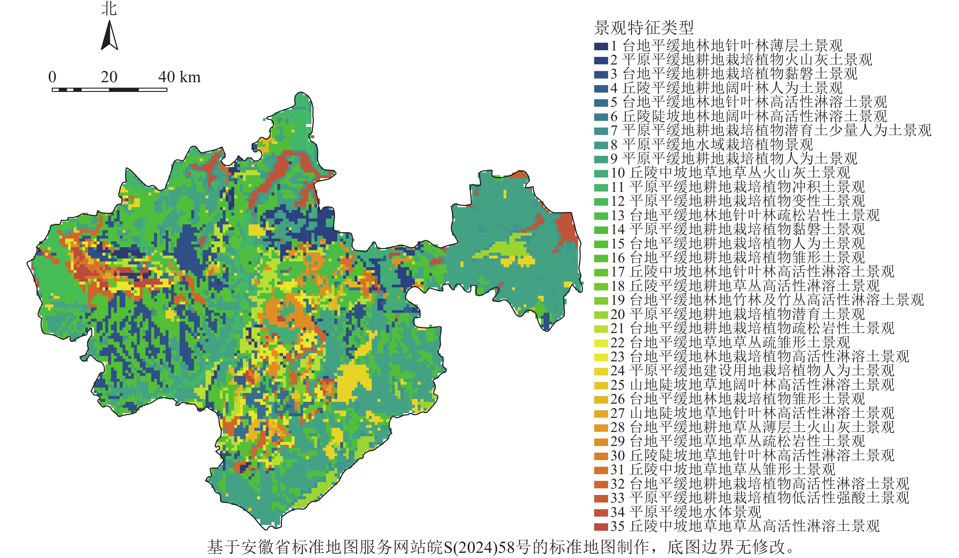
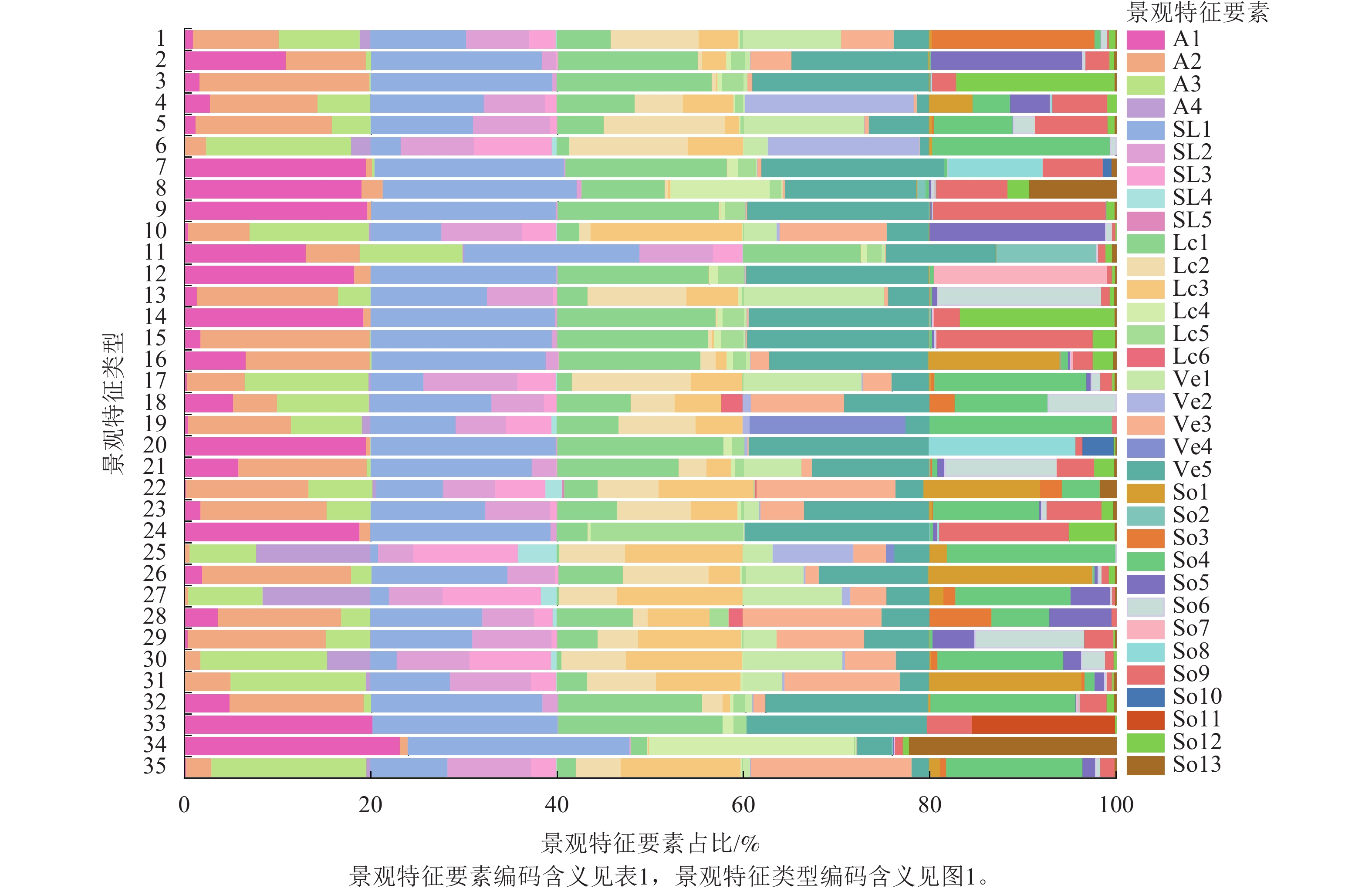
    • 利用K-means模型对各类景观特征要素进行训练,经过200次迭代聚类得到35种景观特征类型(图1~2)。为降低景观破碎度和保持景观特征均质化特性,利用eCognition的多尺度分割工具对景观特征类型进行分割实验,当尺度、形状和紧凑度参数分别为12、0.4、0.1时,自动划分结果最为合适。

      Figure 1.  Landscape character type distribution map of Chuzhou City

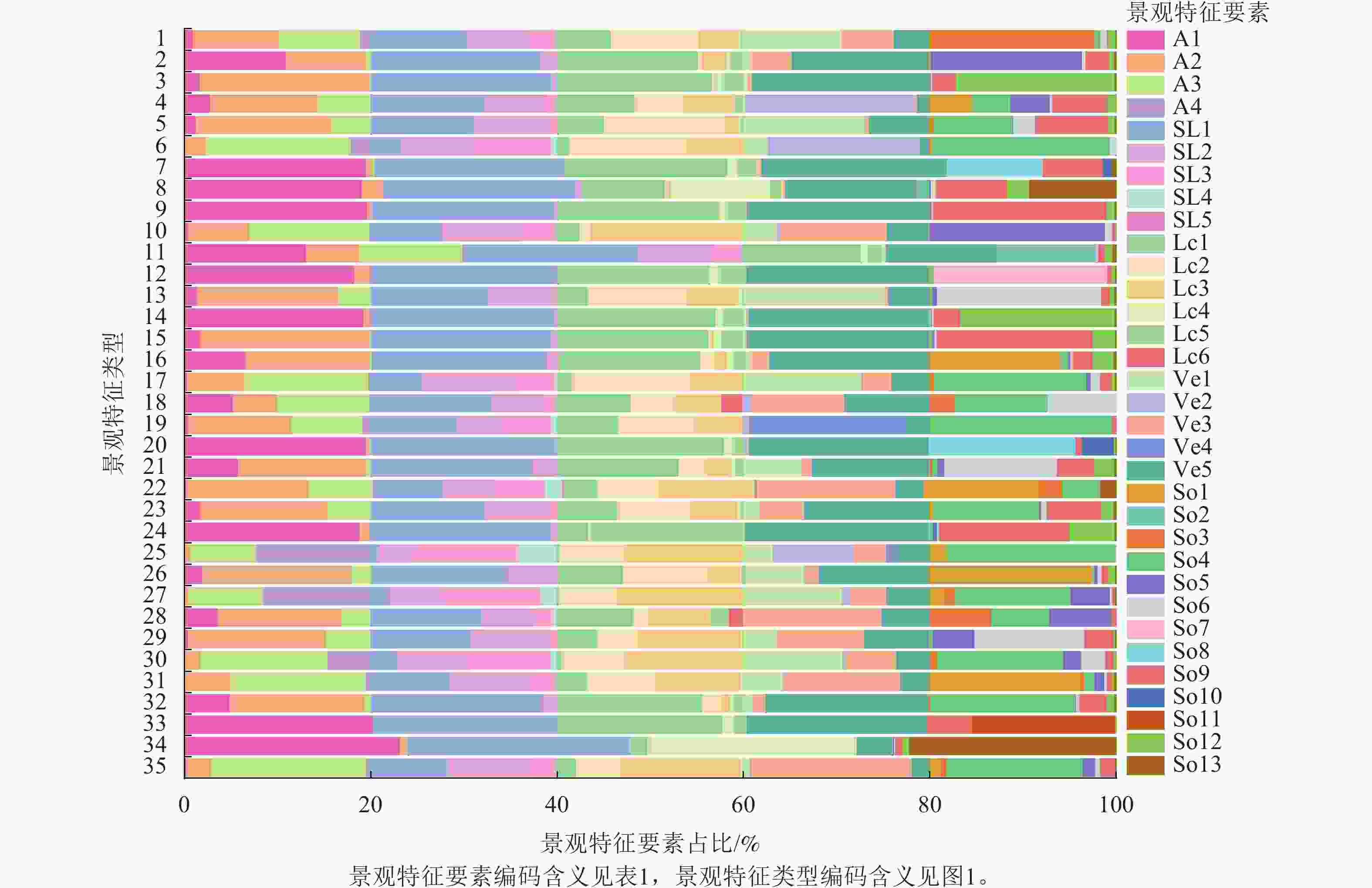
      Figure 2.  The proportion of each landscape element within different landscape character types

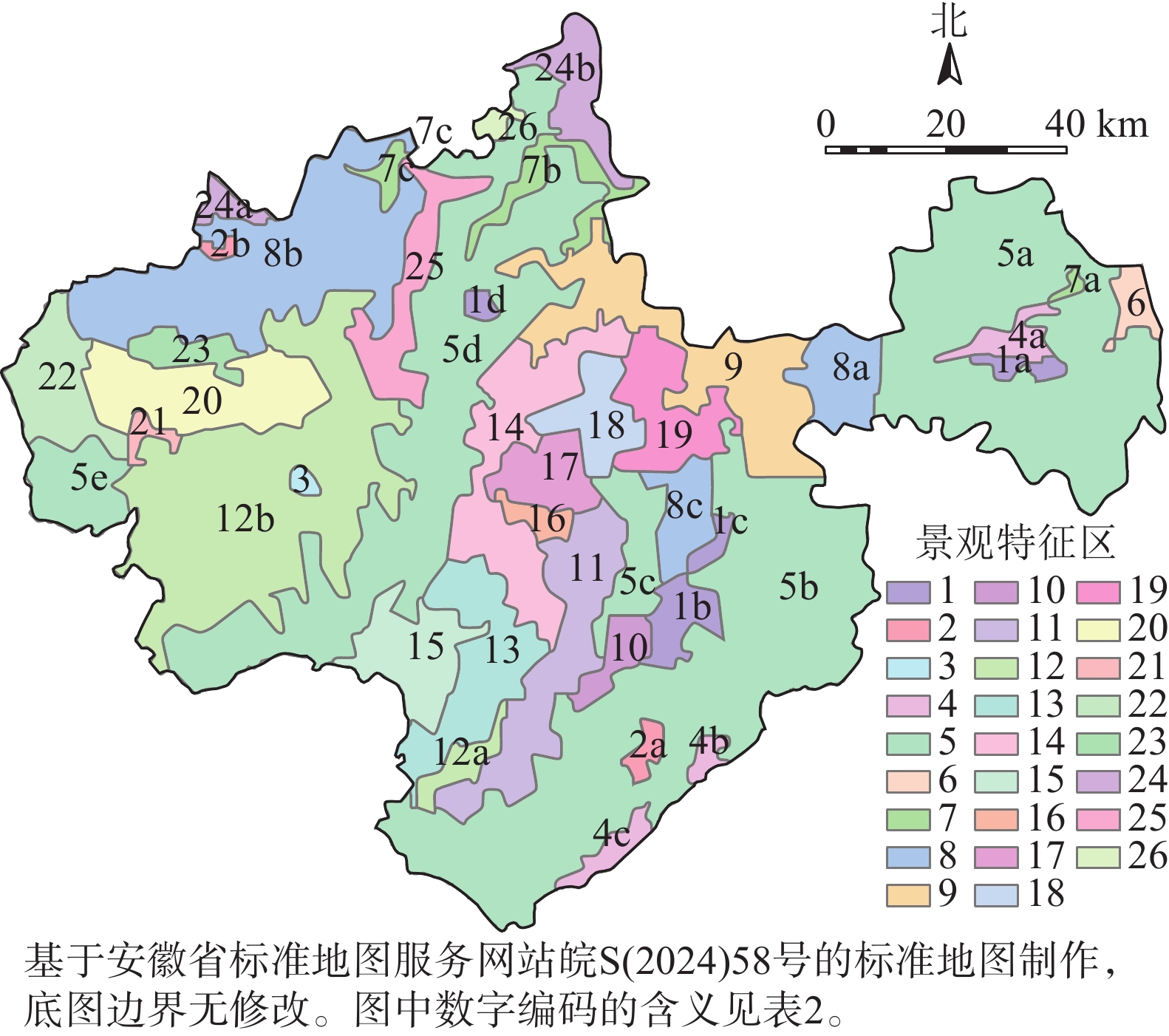
      在比对天地图影像和实地调研的基础上,通过目视解译法将分割后的图像结果进行边界调整,最终确定26类景观特征区(表2图3),并对其进行编码及关键景观特征命名描述。由表2可知:耕地占主导地位的景观特征区编码分别为4、5、8、9、12、14、15、21、22、24、25、26,总面积为9 634.03 km2,占比为80.44%。其中“平原平缓地耕地栽培植被人为土景观(5)”最大,面积为5 574.23 km2,占比为46.53%,分布于来安县、南谯区、全椒县的滁河流域,定远县、明光市的池河流域以及天长市的高邮湖流域,地势较为平坦;“平原平缓地耕地栽培植被雏形土景观(26)”最小,面积为27.2 km2,占比为0.23%,位于明光市紫阳乡境内,淮河流域与女山湖流域之间。

      编码 景观特征区名称 面积/km2 总面积/km2 占比/%
      1 1a 平原平缓地建设用地栽培植被人为土景观 41.06 214.09 1.79
      1b 117.91
      1c 32.47
      1d 22.65
      2 2a 平原平缓地建设用地栽培植被黏磐土景观 39.03 53.63 0.45
      2b 14.60
      3 台地平缓地建设用地栽培植被人为土景观 18.25 18.25 0.15
      4 4a 平原平缓地耕地栽培植被潜育土景观 81.85 179.42 1.50
      4b 32.25
      4c 65.32
      5 5a 平原平缓地耕地栽培植被人为土景观 1 533.50 5 574.23 46.53
      5b 1 993.22
      5c 193.06
      5d 1 640.63
      5e 213.82
      6 平原平缓地水域景观 64.30 64.30 0.54
      7 7a 平原平缓地水域栽培植被景观 13.11 195.22 1.63
      7b 141.54
      7c 40.57
      8 8a 平原平缓地耕地栽培植被黏磐土景观 189.84 541.35 4.52
      8b 201.36
      8c 150.15
      9 台地中缓坡耕地栽培植被火山灰土景观 616.71 616.71 5.15
      10 台地平缓地中坡地林地草丛高活性淋溶土景观 92.68 92.68 0.77
      11 台地平缓地林地栽培植被高活性淋溶土景观 190.60 190.60 1.59
      12 12a 台地平缓地耕地栽培植被人为土景观 77.19 1 463.54 12.22
      12b 1 386.35
      13 台地平缓地林地栽培植被人为土景观 303.30 303.30 2.53
      14 台地中缓坡地耕地栽培植被疏松岩性土景观 171.45 171.45 1.43
      15 台地中缓坡地耕地栽培植被人为土景观 272.80 272.80 2.28
      16 丘陵中坡地林地草丛火山灰土景观 52.84 52.84 0.44
      17 台地中缓坡地林地草丛疏松岩性土景观 172.07 172.07 1.44
      18 台地中缓坡地林地栽培植被疏松岩性土景观 190.36 190.36 1.59
      19 台地中缓坡地林地针叶林疏松岩性土景观 271.93 271.93 2.27
      20 丘陵平缓坡地草地草丛高活性淋溶土景观 429.97 429.97 3.59
      21 台地平缓地耕地栽培植被高活性淋溶土景观 33.55 33.55 0.28
      22 平原平缓地耕地栽培植被变性土景观 277.64 277.64 2.32
      23 台地平缓地林地针叶林薄层土景观 97.73 97.73 0.82
      24 24a 平原平缓地耕地栽培植被冲积土景观 44.14 226.31 1.89
      24b 182.17
      25 台地平缓地耕地栽培植被黏磐土景观 249.83 249.83 2.09
      26 平原平缓地耕地栽培植被雏形土景观 27.20 27.20 0.23
        说明:不同小写字母表示同一类景观特征区分别位于不同地理位置。

      Table 2.  Landscape character area coding, naming, and area statistics

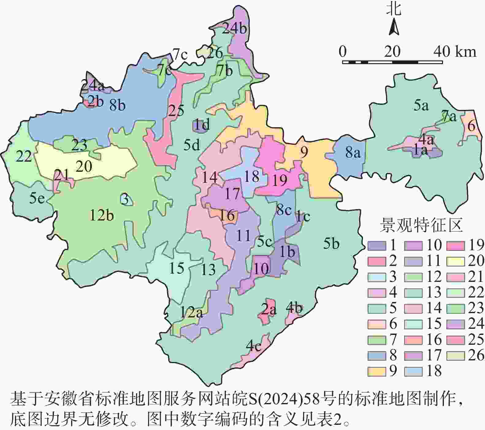
      Figure 3.  Landscape character area distribution map

    • 从4种生态系统服务评价结果(图4)可以看出:生境质量重要性高值区(高度和极重要)面积为2 500.46 km2,占比为18.51%,主要分布在中、西部等植被覆盖度较高的丘陵山区以及高邮湖、淮河、女山湖等水域。高度和极重要水源涵养功能区域面积为36.11 km2,占比为0.27%,水源涵养服务整体功能较差且易旱、缺水。碳固定高值区(高度和极重要)分布在中、西部丘陵山区以及其他植被茂密地区,总面积为5 663.18 km2,占比为41.91%。土壤保持功能高值区(高度和极重要)集中在中、西部,分布较为分散,总面积为568.60 km2。综合来看,4种生态系统服务高值区(高度和极重要)主要集中于滁州市中部和凤阳山区域,横跨南北,与该地区丘陵台地地理走势一致。

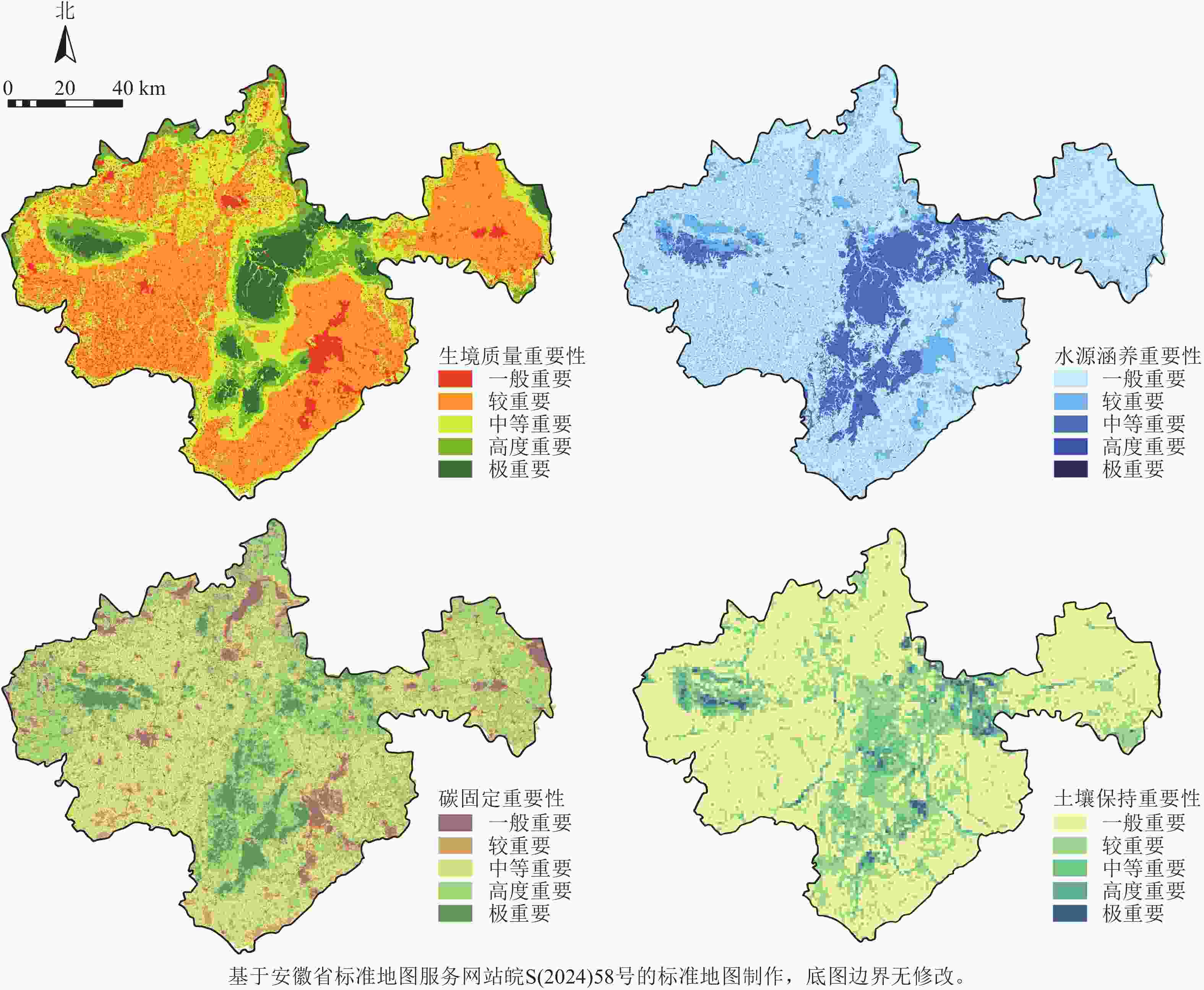
      Figure 4.  Evaluation of the importance of 4 types of ecosystem services

      从综合生态系统服务评价(图5)可知:乡村景观综合生态系统服务一般重要、较重要、中等重要、高度重要和极重要面积分别为1 556.66、5 241.56、4 127.71、1 340.84和1 218.85 km2,分别占研究区总面积的11.54%、38.87%、30.61%、9.94%和9.04%。较重要、中等重要等级占比为69.48%,分布于滁州市东部、东南部、西部和北部等,且拥有大量耕地(水田和旱地),表明土地开发强度较大,破坏了生态系统稳定性,导致生态系统服务能力降低;高度和极重要等级面积仅占研究区总面积的18.98%,主要分布于全椒县孤山,南谯区南、北将军山,定远县岱山,明光市杏山至来安县半塔的大片高低丘相连的弧形带状岗地区和凤阳山、老嘉山两片丘陵区。该区域属于平缓丘陵地区(海拔>100 m),具有较高的植被覆盖度,为区域生态系统可持续发展运行提供了关键支撑。中等及以上重要性等级面积为10 925.93 km2,分布于滁州市大部分平缓坡岗地和平原地区。总体上,综合生态系统服务空间分布与生境质量、水源涵养、碳固定和土壤保持4个生态系统服务空间分布较为一致,均呈现出中部带状分布延展,西部凤阳山集中分布的“一带一心”空间格局。

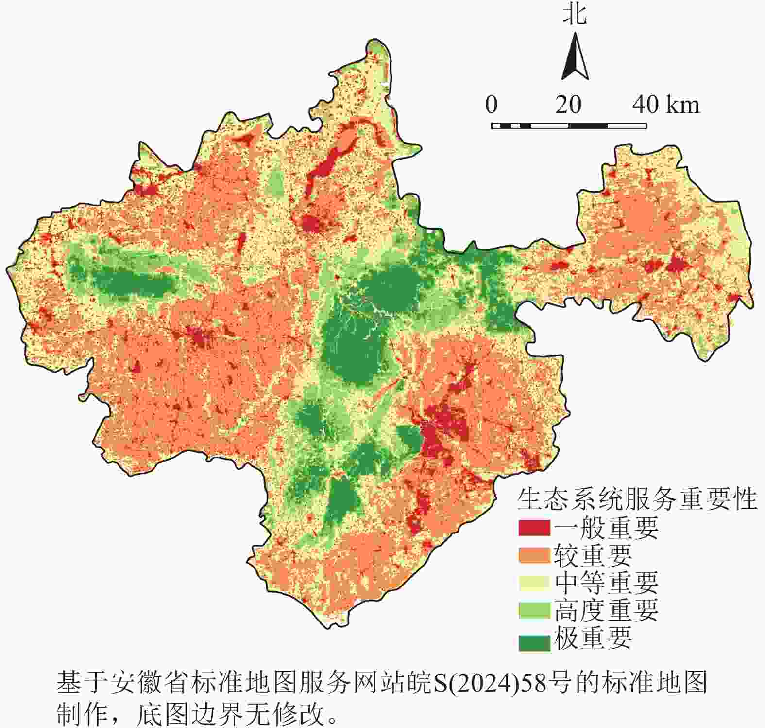
      Figure 5.  Comprehensive evaluation of the importance of ecosystem services

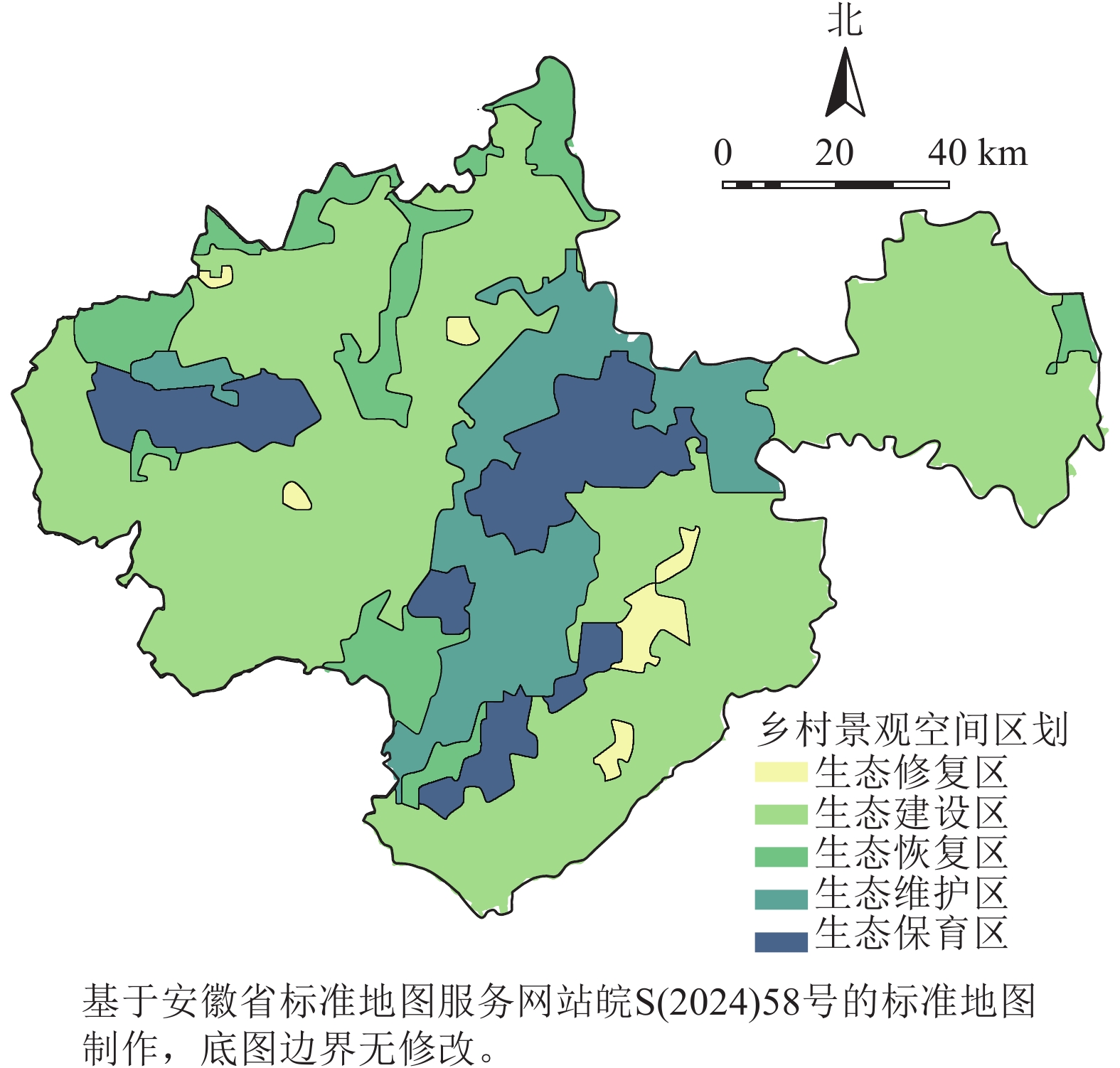
    • 综合景观特征区识别与生态系统服务评价,将滁州市乡村景观空间划分为生态修复区、生态建设区、生态恢复区、生态维护区、生态保育区(图6),分别占研究区总面积的1.81%、63.14%、10.50%、20.79%、3.76%。其中生态修复区、生态建设区、生态恢复区面积占研究区的75.45%,其空间分布基本与生态系统服务中等及以下重要性等级覆盖区域一致,均属于乡村景观管控的重点区域。

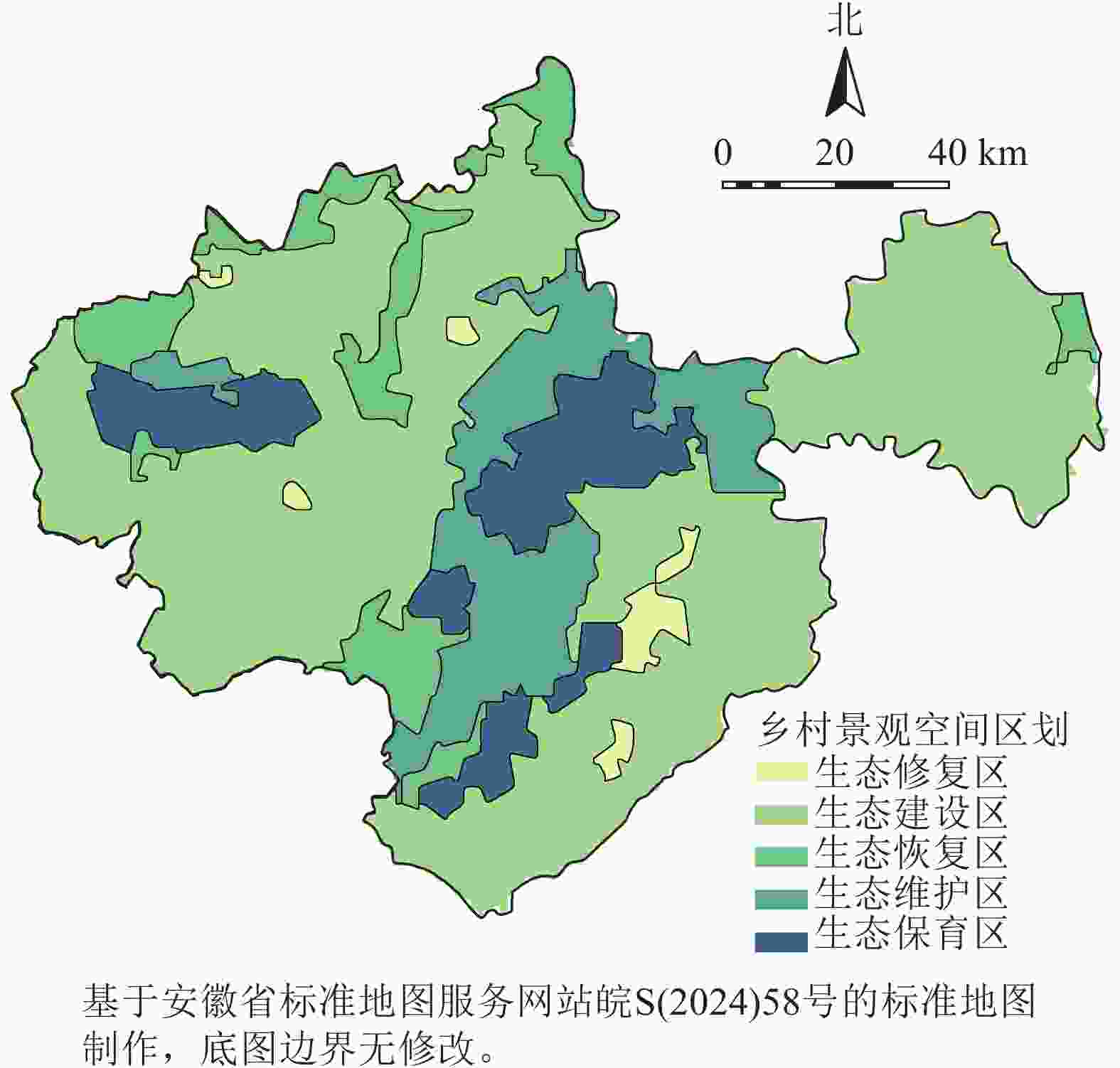
      Figure 6.  Landscape zoning of rural areas in Chuzhou City

      生态保育区生态系统服务功能极为重要,集中于三界镇、老嘉山、琅琊山,多为台地丘陵林地,平均植被覆盖度为69.80%,面积为507.91 km2。涵盖“丘陵中坡地林地草丛火山灰土景观(16)”“台地中缓坡地林地草丛疏松岩性土景观(17)”“台地中缓坡地林地栽培植被疏松岩性土景观(18)”“台地平缓地中坡地林地草丛高活性淋溶土景观(10)”,占比分别为10.40%、33.88%、37.48%、18.25%。

      生态维护区生态系统服务功能为高度重要,位于滁州市中部和凤阳山,主要为台地地貌,林地为主,平均植被覆盖度为63.72%,面积为2 808.68 km2。该区域涵盖“台地中缓坡耕地栽培植被火山灰土景观(9)”“台地平缓地林地栽培植被高活性淋溶土景观(11)”“台地平缓地林地栽培植被人为土景观(13)”“台地中缓坡地耕地栽培植被疏松岩性土景观(14)”“台地中缓坡地林地针叶林疏松岩性土景观(19)”“丘陵平缓坡地草地草丛高活性淋溶土景观(20)”“台地平缓地林地针叶林薄层土景观(23)”,占比分别为29.63%、9.15%、14.57%、8.24%、13.06%、20.65%、4.69%。

      生态恢复区分布在滁州市东部、西南部、西部、北部,包括高邮湖与淮河沿岸,凤阳山西部、石门山等区域,空间分布较为分散,以耕地和河湖滩涂水田为主,平均植被覆盖度为50.72%,面积为1 418.64 km2。涵盖“平原平缓地水域景观(6)”“平原平缓地耕地栽培植被黏磐土景观(8a)”“台地平缓地耕地栽培植被人为土景观(12a)”“台地中缓坡地耕地栽培植被人为土景观(15)”“平原平缓地耕地栽培植被变性土景观(22)”“平原平缓地耕地栽培植被冲积土景观(24a、24b)”“台地平缓地耕地栽培植被粘磐土景观(25)”“平原平缓地耕地栽培植被雏形土景观(26)”,占比分别为0.54%、1.58%、0.64%、2.28%、2.32%、1.89%、2.09%、0.23%。

      生态建设区分布于滁州市大部分地区,以平缓坡耕地为主,平均植被覆盖度为45.80%,面积为8 531.17 km2。涵盖“平原平缓地耕地栽培植被潜育土景观(4a、4b、4c)”“平原平缓地耕地栽培植被人为土景观(5a、5b、5c、5d、5e)”“平原平缓地水域栽培植被景观(7a、7b、7c)”“平原平缓地耕地栽培植被黏磐土景观(8b、8c)”“台地平缓地耕地栽培植被人为土景观(12b)”,占比分别为1.50%、46.53%、1.63%、2.93%、11.57%。

      生态修复区位于滁州市、全椒县、明光市、定远县、凤阳县等城镇建成区,平均植被覆盖度为19.02%。面积为244.87 km2。涵盖“平原平缓地建设用地栽培植被人为土景观(1a、1b、1c、1d)”“平原平缓地建设用地栽培植被黏磐土景观(2a、2b)”“台地平缓地建设用地栽培植被人为土景观(3)”,占比分别为1.79%、0.45%、0.15%。

    • 本研究结果显示:碳固定、土壤保持、生境质量3个指标较高等级在滁州市中部形成连续的“南北走向”生态系统服务带,在西部形成独立生态系统服务“核心”。这与黄木易等[32]关于滁州市生态系统服务研究的结果较为一致。造成这一空间分布格局的可能原因是滁州市中部、西部(凤阳山)具有较好的生态本底条件,如老嘉山、皇甫山、神山、琅琊山及凤阳山等,不仅植被覆盖率高,且空间分布较为集中连片。此外,本研究修正产水量得到的水源涵养量(平均值为92.26 mm)约占InVEST模型估算产水量(平均值为500.86 mm)的18.42%。说明地形坡度、土层深度对滁州市的水源涵养生态系统服务影响较大,也在一定程度上印证了江淮分水岭地区“降雨集中、停滞难、流失多”的水资源特征[33]

      本研究综合了海拔、地形、土地利用、植被、土壤等多种影响因子,较为准确把握了乡村景观特征。相较于张继力等[25]建构自然、文化两大影响因子对山西省太原市晋源区进行乡村景观特征识别,本研究仅考虑了自然景观要素对乡村景观特征识别的作用,有待进一步建构包括文化属性指标的景观特征识别研究。另一方面,以往研究多以行政边界作为乡村景观区划分析的基本单元,忽略了景观感知尺度、景观异质性及边界效应的影响。本研究采用1 000 m×1 000 m为景观特征分析的网格采样尺度,这一采样尺度是接近人的景观“可视”距离[34]的采样法,在类似研究中也有应用[3536]。同时,本研究归纳出研究区26类景观特征区,并据此作为划分单元,考虑了景观的空间异质性与多样性,更能够体现出实际空间区划价值,为决策制定者、管理者提供实操性工具。

      结合滁州市乡村景观实际情况和空间划分结果,提出优化管控建议:①生态保育区应实施严格的保护制度,加强科学管理,限制一切与生态保育无关的人为开发建设活动,从而保障生态系统服务质量和稳定性,突出生态系统服务功能的溢出效应。②生态维护区以生态保护为主,开发服从保护的原则进行生态管理。空间用途上可适当进行非建设性破坏的观光休闲、自然科普教育等活动。坚持退耕还林政策,以强制性保护措施维护区域生态安全,最大限度发挥生态系统服务功能。③生态恢复区位于河流、湖泊、浅山等生态较为敏感地区,应采用自然恢复和人工修复相结合模式,加强对生态受损区域修复,建设生态防护隔离带;严格限制区域内林地、湿地等生态空间被侵占和破坏。④生态建设区应充分结合自然环境和农业发展状况,因地制宜地发展生态保护与农业生产相结合的现代农业,加强耕地保护,重点推进基本农田、旱地等耕地综合整治与修复建设,避免耕地荒化,建设高标准农田;开展农田林网复合种植建设,发挥农田生态系统综合效益。配合和美乡村建设,建设中心村,提高土地集约利用水平;建立农村人居环境管理长效机制,激发农民主体作用,配合农村人居环境整治行动,加强宅前宅后用地、菜园、溪塘等用地生态建设,选用本土树种、经济树种开展农村绿化行动,提高区域植物覆盖度。充分利用好岗地湿地,提高湿地蓄水能力,采用多层级河渠生态建设工程,提高区域水源涵养功能。加强水土保持能力建设,采用“集中连片式”“复合种植方式”大力推动荒地、荒坡绿化行动,防范水土流失风险。⑤生态修复区应加强城镇绿地系统建设,构建城乡一体化生态网络;鼓励有条件地方开展屋顶绿化、建筑绿色化改造、多层次复合绿地植被“补绿”等综合建设,一方面削弱灰色基础设施对城镇生态空间的影响,另一方面提高原有绿地生态系统服务效益。

      本研究为乡村景观区划与管控提供了新的研究思路,但在景观特征要素选择、生态系统服务评估以及景观特征与生态系统服务耦合方法上仍然有改进与提升空间,未来可在将文化景观特征要素纳入聚类分析、考虑多种生态系统服务权衡与协同及其与景观特征要素依赖关系等方面进一步进行研究。

    • 滁州市划分出35种乡村景观特征类型和26类乡村景观特征区,耕地占主导地位的景观特征区为研究区主要景观特征区,其面积为9 634.03 km2,占比达80.44%。研究区生境质量、水源涵养、碳固定、土壤保持及综合生态系统服务均呈“一带一心”空间格局,即中部区域带状延展,西部凤阳山集中分布。融合景观特征和生态系统服务功能,研究区划分为生态修复、生态建设、生态恢复、生态维护、生态保育5类管控分区,其中生态修复区、生态建设区、生态恢复区为滁州市乡村景观管控重点区域,总占比为75.45%。本研究提出的“景观特征识别+生态系统服务评价”乡村景观区划与管控方法可有效保持景观的异质性和整体性,反映出乡村景观的地域性和生态性特征,为区域乡村振兴规划和乡村可持续发展管理提供精准科学支撑。

Reference (36)

Catalog

    /

    DownLoad:  Full-Size Img  PowerPoint
    Return
    Return