


-
维持和改善生态系统服务是实现区域可持续发展的基本条件[1],开展生态系统服务的量化评估以实现生态系统有效管理,对保障区域可持续发展具有重大意义[2-3]。在众多生态系统服务中,水源涵养服务占据着重要的地位,对改善区域水文状况、调节区域水分循环发挥着关键作用[4-5]。生态系统是具有空间差异的复杂系统,其水源涵养服务又受到气候、地形、植被、土壤、土地利用、社会经济等多种自然和人文因素的影响,导致水源涵养服务也存在显著的空间差异。定量化与空间可视化评估已成为水源涵养服务评价的最新趋势,也是水资源有效管理和保护决策的重要需求[6]。
目前,国内外学者们已使用地理信息系统(GIS)、InVEST模型、SWAT模型等方法开展了大量的水源涵养服务空间可视化评估[7-9],并对不同地区、不同尺度的水源涵养服务空间格局及其影响因素进行了研究,如全中国[10]、江苏省[11]、商洛市[12]、甘肃白龙江流域[3]、秦岭地区[13]等。研究大多通过分区统计比较不同子流域、不同行政单元、不同海拔、不同土地利用方式、不同植被覆盖下水源涵养服务的差异[3, 10-13],并使用相关性分析、回归分析、主成分分析等探讨水源涵养服务与其影响因素之间的关系[10-12],但这些传统的统计模型构建中忽略了各变量的空间依懒性和空间异质性。近年来,空间回归模型如空间误差模型(SEM)、空间滞后模型(SLM)、地理加权回归模型(GWR)等受到广泛关注。张佳田等[14]通过SEM模型测度生态系统服务能力与城镇化水平及各子系统得分关系。梁晓瑶等[15]基于InVEST模型评估了黑龙江省的生境质量,利用多尺度GWR模型,探究了影响生境质量的自然和人文要素作用空间尺度差异及其影响程度。赵育恒等[16]对武汉城市圈生态服务价值时空演变分析及影响因素进行研究表明:SEM模型消除了由地域空间自相关带来的空间误差影响,使得模型更加稳健和准确。然而,使用空间回归模型探讨生态系统水源涵养服务影响因素的研究尚处于起步阶段。
西江是珠江水系最大的支流,西江流域是贯通珠江—西江经济带陆海丝绸之路的重要通道,也是广西粮食主产区和珠江流域重要的生态屏障。广西西江流域水源涵养服务直接关系到该区域的水源安全和供水安全,对该区域社会经济发展至关重要,但目前对广西西江流域水源涵养服务的研究较少。因此,本研究基于InVEST模型,在小流域尺度上空间可视化评估该区域水源涵养服务,并使用GeoDa分析水源涵养空间格局,构建空间统计模型,辨识关键影响因素,最终基于ArcGIS进行水源涵养服务重要性分级和空间分区以识别水源涵养优先和重点保护的区域,以期为流域水资源利用、分区管理与综合保护等提供重要参考。
-
西江作为珠江的主干流,全长2 214 km,横跨云南、贵州、广西、广东4个省(自治区)。广西西江流域(21°35′~26°13′N,104°26′~112°04′E)面积为20.29×10⁴ km2,流域内主要支流有南盘江、红水河、柳江、右江、左郁江、桂贺江和黔浔江。该流域地处亚热带季风气候区,湿润多雨,夏长冬短,年均气温为16.5~23.1 ℃,年均降水量为1 080~2 760 mm。地貌复杂多样,属山地丘陵性盆地地貌,岩溶地貌发育。土壤类型多样,红壤比例大,石灰岩土广布。主要植被类型为森林(马尾松Pinus massoniana和甜槠Castanopsis eyrei等)、灌丛(假鹰爪Desmos chinensis)、草地(野古草Arundinella anomala)和栽培植被(水稻Oryza sativa和甘蔗Saccharum officinarum等)[17]。
-
利用InVEST模型的产水模块估算研究区产水量。该模块根据水量平衡原理,基于气候、地形和土地利用,利用降水量减去实际蒸散量计算每个栅格的径流量。计算公式如下:
$$ {Y}_{jx}=\left(1-\frac{{A}_{xj}}{{P}_{x}}\right){P}_{x}。 $$ (1) 式(1)中:Yjx为第j土地利用类型栅格x的年产水量(mm);Px为栅格单元x的年均降水量(mm);Axj为第j土地利用类型栅格x的实际年均蒸散发量(mm);计算过程参考InVEST模型用户手册与文献[4]。
-
使用水源涵养量表征生态系统水源涵养服务。水源涵养量是降水量减去蒸散发和地表径流后,土壤层可调节的水量,即在产水量的基础上,再用地形指数、土壤饱和导水率和流速系数对产水量进行修正[18],计算公式为:
$$ W=\mathrm{m}\mathrm{i}\mathrm{n}\left(1\text{,}\frac{249}{V}\right)\times \mathrm{m}\mathrm{i}\mathrm{n}\left(1\text{,}\frac{0.9 T}{3}\right)\times \mathrm{m}\mathrm{i}\mathrm{n}\left(1\text{,}\frac{K}{300}\right)Y \text{;} $$ (2) $$ T=\mathrm{l}\mathrm{g}\left(\frac{\mathrm{Q}}{DS}\right) 。 $$ (3) 式(2)~(3)中:W为水源涵养量(mm);V为流速系数;K为土壤饱和导水率(mm·d−1),具体计算方法见文献[19-20];Y为产水量(mm);T为地形指数;Q为集水区栅格数量;D为土壤厚度(mm);S为百分比坡度(%)。min为ArcGIS栅格计算器中取最小值函数。
-
全域莫兰指数是应用最为广泛的检验全域空间自相关的统计量,取值为[−1,1],正值表示空间聚集现象,负值表示空间分散现象,0表示空间上随机分布[21-22]。局域空间自相关可测度整个区域中一个单元上的某一属性与邻近单元同一属性值的相关程度,主要通过空间关联的局部指标分布图揭示各指标的空间关联结构模式[21-22]。全域莫兰指数的计算公式为:
$$ {I_{\rm{g}}} = \frac{{n\displaystyle\sum\limits_{j = 1}^n {\sum\limits_{k = 1}^n {{W_{jk}}{Z_j}{Z_k}} } }}{{\displaystyle\sum\limits_{j = 1}^n {\displaystyle\sum\limits_{k = 1}^n {{W_{jk}}} } \sum\limits_{j = 1}^n {Z_j^2} }}。 $$ (4) 式(4)中:Ig为全域莫兰指数;n为观测总数;Zj、Zk分别为第j、k个斑块观测值与所有斑块观测值的均值之差。Wjk为空间权重,若斑块j与k相邻,则Wjk为1,否则Wjk为0。使用标准化统计量(Z)表征空间自相关的显著性,计算公式为:
$$ Z=\frac{{I}_{\mathrm{g}}-E}{\sqrt{V}} 。 $$ (5) 式(5)中:E为Ig的期望值;V为Ig的方差。在0.05的置信水平下,|Z|=1.96,以|Z|>1.96表示该区域的空间自相关是显著的。
局域莫兰指数的计算公式为:
$${I_l} = \frac{{{Z_j}\displaystyle\sum\limits_{j = 1}^n {{W_{jk}}{Z_k}} }}{{\dfrac{1}{n}\displaystyle\sum\limits_{j = 1}^n {Z_j^2} }}。 $$ (6) 式(6)中:Il为局域莫兰指数,其余变量含义与式(4)相同。根据Il、Zj与显著性检验结果,可将第j个斑块与周边斑块观测值的相关性划分为高-高聚集、高-低聚集、低-低聚集、低-高聚集和不显著5种类型,即局部指标分布图[21-22]。
-
相关研究表明:水源涵养的空间差异与气候、植被、土地利用、土壤和社会经济有关[10-12],地形则是通过影响自然和人文要素的梯度差异来改变水源涵养的分布格局[3]。
如果因变量或自变量存在空间自相关性,将导致经典线性回归模型的残差也存在空间自相关,从而其回归系数和拟合优度(R2)都将产生偏性和大方差,此时应当使用空间回归模型[23]。本研究使用GeoDa构建空间回归模型对流域水源涵养服务影响因素进行定量分析,对比不同空间回归模型结果以选择相应的模型,模型R2和对数似然值越大,模型拟合程度越好,而赤池信息准则和施瓦兹准则统计量越小,则模型拟合程度越好[23]。
-
根据InVEST模型需求和数据可获取性,以2015年为典型年,进行实证研究。模型所需数据有多年平均降水量、潜在蒸散量、土地利用类型、土壤厚度、植被可利用水、流域及小流域边界、生物物理参数表、地形指数、土壤饱和导水率以及产水量验证数据。
多年平均降水量与潜在蒸散量。以广西西江流域内及周边61个气象站点2001—2015年降水、气温、实际水汽压、风速、相对湿度、日照百分率为数据,在ArcGIS中使用样条函数插值获取研究区多年平均降水量与多年平均潜在蒸散量栅格图层,其中,潜在蒸散量采用联合国粮食与农业组织(FAO)给出的修正Penman-Monteith方程[24]计算而来。
土地利用类型。获取2015年的广西西江流域土地利用数据,一级分类为耕地、林地、草地、水域、城乡-工矿-居民用地和未利用地6类。数据来自中国科学院资源环境科学数据中心(
http://www.resdc.cn )。土壤厚度、植被可利用水以及土壤饱和导水率。土壤厚度、黏粒含量、粉粒含量、砂粒含量、土壤有机质含量数据来自中国1∶100万土壤数据库。植被可利用水根据土壤质地计算,土壤饱和导水率根据土壤砂粒含量计算[19-20],详细计算过程参考模型手册以及文献[3-4]。
小流域边界和地形指数。根据数字高程模型(DEM),使用ArcGIS中的水文分析获得小流域边界,既要尽可能细化小流域范围,合理表达河网稠密度等级下的集水盆地,便于后续空间展示,又要避免小流域细碎不利于模型计算,经过反复汇流累积阈值试验,最终汇流累积阈值设定为5 000时,小流域平均面积约141 km2,共划分了1 438个小流域。地形指数根据式(3)计算。DEM来自中国科学院资源环境科学数据中心(http://www.resdc.cn)。
生物物理参数表。此表需要获取不同土地利用类型的植被蒸散系数、最大根系深度和流速系数。根据参考文献[3, 25-26]、模型使用手册中推荐的参数和广西西江流域的实际情况确定相关参数。
产水量验证数据。使用地表水资源量对模拟产水量进行验证,2001—2015年广西西江流域地表水资源量数据来自广西壮族自治区水利厅官方网站(
http://slt.gxzf.gov.cn/ )。 -
选取气候(多年平均降水量、实际蒸散量),地形(坡度、海拔),土地利用(林地面积比例、耕地面积比例),植被与土壤[植被净初级生产力(NPP)、土壤饱和导水率、植被可利用水、土壤厚度]以及社会经济(人口密度、经济密度、不透水率)共13个因子作为水源涵养服务的影响因素。其中,多年平均降水量、土壤饱和导水率、植被可利用水、土壤厚度来源同2.5.1部分;坡度、海拔来源于DEM;实际蒸散量来自InVEST模型产水结果中间数据;林地面积比例、耕地面积比例和不透水率根据土地利用中林地面积、耕地面积和建设用地面积与各小流域面积之比计算;NPP使用CASA模型计算;人口密度与经济密度是根据2016年《广西统计年鉴》中各区县常住人口、国内生产总值与各区县行政面积之比计算。使用ArcGIS将13个因子进行分区统计得到小流域矢量数据。
-
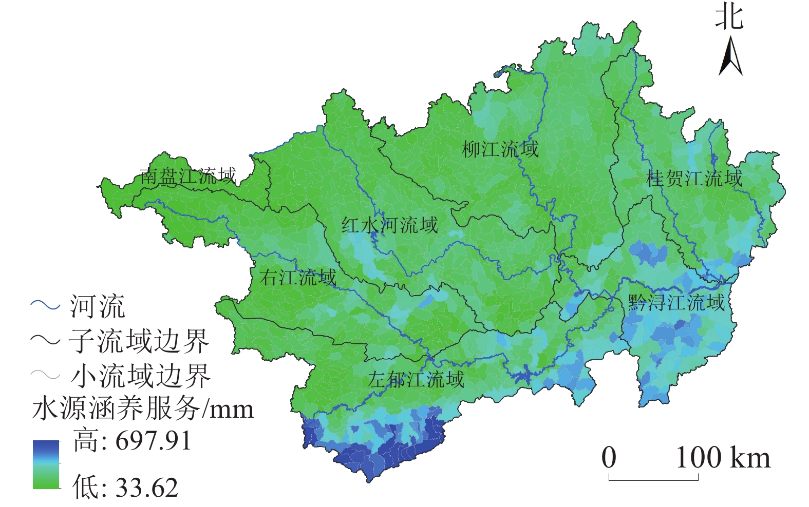
根据研究区地表水资源量数据,计算出广西西江流域2001—2015年多年平均径流量为1 547.21亿 m3,经过反复模拟计算,当Zhang系数为6.933时,模拟产水量相对误差为1.63%,此时模拟结果最优。在此产水结果上,根据式(2)和式(3),计算研究区水源涵养量。结果显示:广西西江小流域多年平均水源涵养量为33.62~697.91 mm,平均为185.36 mm,标准差为106.26 mm,2015年水源涵养总量为376.10亿 m3,占多年平均产水量的23.90%,远高于2015年广西总用水量285.2亿 m3。研究区内水源涵养量呈现出明显的空间差异(图1),各子流域水源涵养量平均值由高到低依次为黔浔江流域(298.11 mm)、左郁江流域(251.94 mm)、桂贺江流域(194.06 mm)、柳江流域(148.80 mm)、红水河流域(144.04 mm)、右江流域(136.47 mm)、南盘江流域(65.57 mm),流域内水源涵养量的空间差异主要受降水、土壤性质、植被生长和地形等因素空间异质性的共同影响。水源涵养量较高的区域分布在左郁江流域南部地区以及黔浔江流域内,小流域多年平均水源涵养量为300.00~697.91 mm,该区域降水量较高,植被茂密,形成良好的土壤结构及通风状况,其土壤下渗、持水能力较强,水源涵养服务水平高。水源涵养量较低的区域主要分布在南盘江流域内,在右江流域、红水河流域、柳江流域、桂贺江流域以及左郁江流域北部地区有零星分布(图1),小流域多年平均水源涵养量小于100.00 mm,该区域降水量低、土壤饱和导水率偏低是导致水源涵养服务偏低的主要原因。

图 1 广西西江流域水源涵养服务空间分布示意图
Figure 1. Spatial distribution of water retention service in Xijiang River Basin of Guangxi
-
降水量和实际蒸散发是影响水源涵养服务的重要气候因子。从图2A可知:广西西江流域多年平均降水量为1 526.36 mm,空间差异明显,主要表现为由西北向东南逐渐增加的趋势,并与流域产水量的空间分布一致。构建最小二乘法回归模型(OLS)发现:本研究中降水量可以解释产水量变化的91.68%,是产水量最重要的影响因素;降水量可以解释水源涵养量变化的30.47%,降水量与水源涵养量具有较为一致的空间分布特征,表明降水量对水源涵养服务具有重要影响。
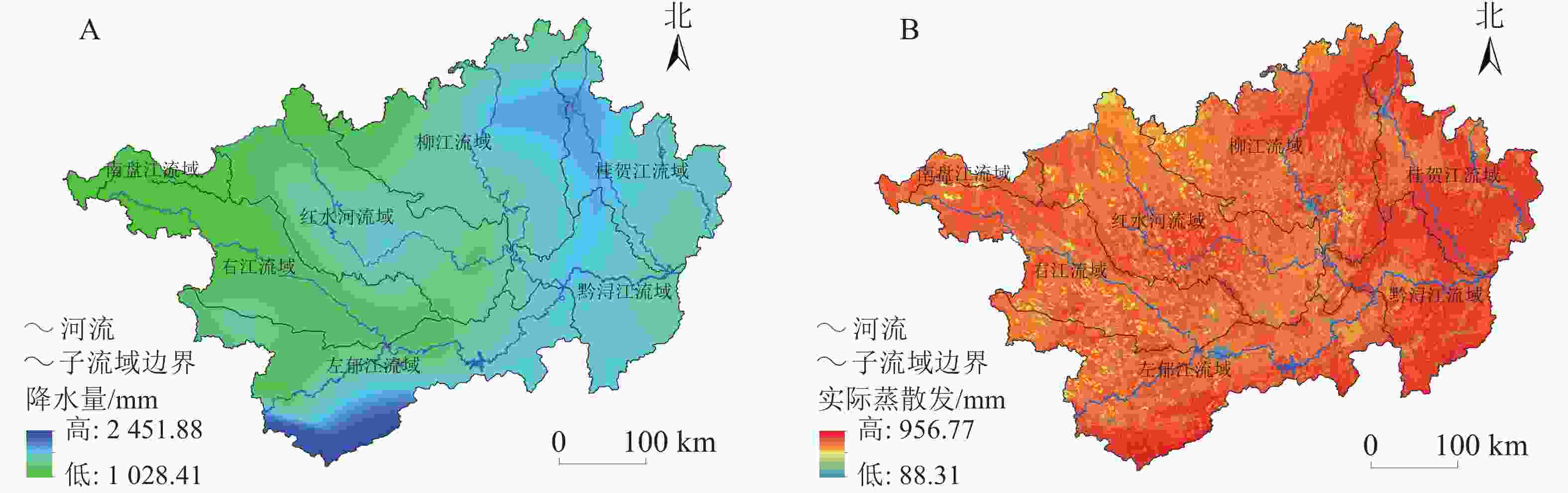
图 2 广西西江流域多年平均降水量(A)与实际蒸散发(B)空间分布示意图
Figure 2. Spatial distribution of average annual precipitation (A) and actual evapotranspiration (B) in Xijiang River Basin of Guangxi
实际蒸散发是水循环的重要环节,与降水、植被和土壤密切相关。研究区实际蒸散发较大,平均为751.41 mm,且存在显著的空间差异,主要表现为由西北向东南逐渐增加的趋势(图2B)。尽管左郁江流域南部和黔浔江流域的实际蒸散发较大,但该区域降水量高,加之植被与土壤的综合作用,使得该区域水源涵养量高于其他区域。OLS结果显示:实际蒸散发与降水量之间存在一定的共线性,两者可以解释水源涵养服务变化的36.00%。
-
使用ArcGIS分区统计以对比不同土地利用类型的水源涵养量平均值,结果显示:不同土地利用类型水源涵养量平均值由高到低依次为林地(251.78 mm)、灌丛(184.63 mm)、草地(162.82 mm)、耕地(58.73 mm),其中,林地的水源涵养量平均值高于流域平均值。本研究中,不同土地利用类型植被净初级生产力平均值由高到低依次为林地(973.58 g·m−3)、草地(884.95 g·m−3)、灌丛(832.80 g·m−3)、耕地(660.42 g·m−3),对于林地而言,较高的净初级生产力可积累较多的生物量,群落层次丰富且密封性好的林地,林冠和凋落物的截留作用可减少地表径流;灌丛和草地由于地上生物量相比林地较少,导致地表产流较大,水源涵养服务有所降低[13];耕地由于受人类活动影响,其地上生物量更受季节性收获而变动,导致地表产流量增大,水源涵养服务降低。
-
土壤是影响水源涵养服务的重要因子,通过土壤的孔隙结构特性,与植物根系、土壤生物共同实现水分的蓄积和再分配[27]。由图3可知:广西西江流域土壤饱和导水率平均为100.70 mm·d−1,存在显著空间差异,其高值主要分布在右江流域、左郁江流域和黔浔江流域,由北向南呈现逐渐增加的趋势。对比图1和图3发现:广西西江流域水源涵养空间分布与土壤饱和导水率的空间分布较为一致。OLS结果显示:土壤饱和导水率可以解释水源涵养量变化的53.70%,是水源涵养服务最重要的影响因素。
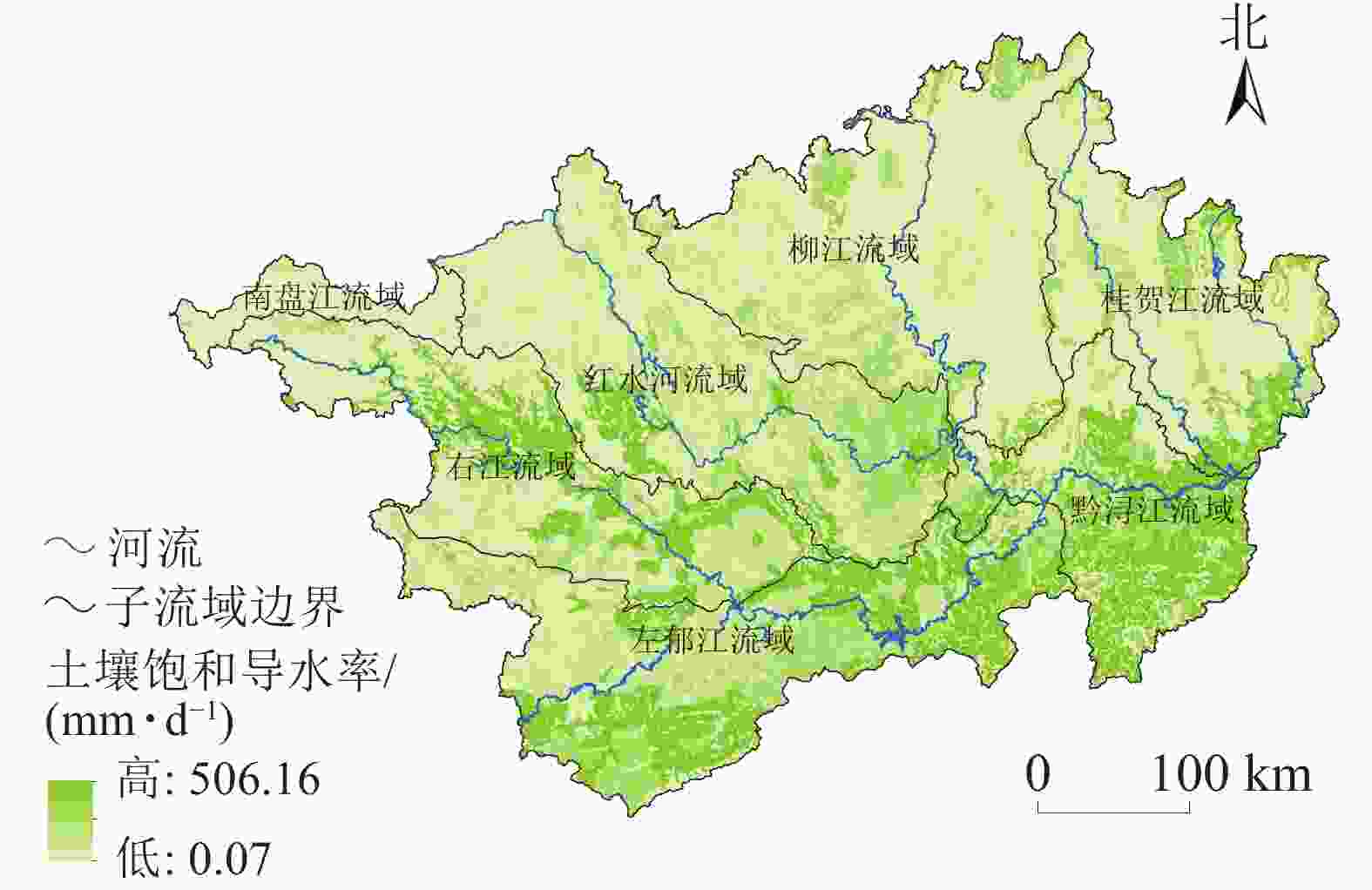
图 3 广西西江流域土壤饱和导水率空间分布示意图
Figure 3. Spatial distribution of soil saturated hydraulic conductivity in Xijiang River Basin of Guangxi
-
相关研究表明:水源涵养量与人口密度呈负相关[3]。在流域尺度上,水源涵养服务与社会经济的相关性较弱;而在栅格尺度上,经济发展、人口增长、城镇化水平的提高,对水源涵养服务带来了负面影响[11]。OLS结果显示:人口密度、经济密度和不透水率3个指标仅可以解释水源涵养服务变化的6.86%,但三者均通过显著性检验。可见,社会经济因素对水源涵养服务具有显著影响,但影响程度较弱。
-
全域空间自相关分析表明:全域莫兰指数为0.769,P为0.001,通过了Z检验,表明小流域尺度上广西西江流域水源涵养服务在空间分布上存在空间依赖性,说明水源涵养服务在空间分布上是集聚分布的。即高水源涵养量的小流域与较高水源涵养量的小流域相靠拢,而低水源涵养量的小流域与较低水源涵养量的小流域相邻。
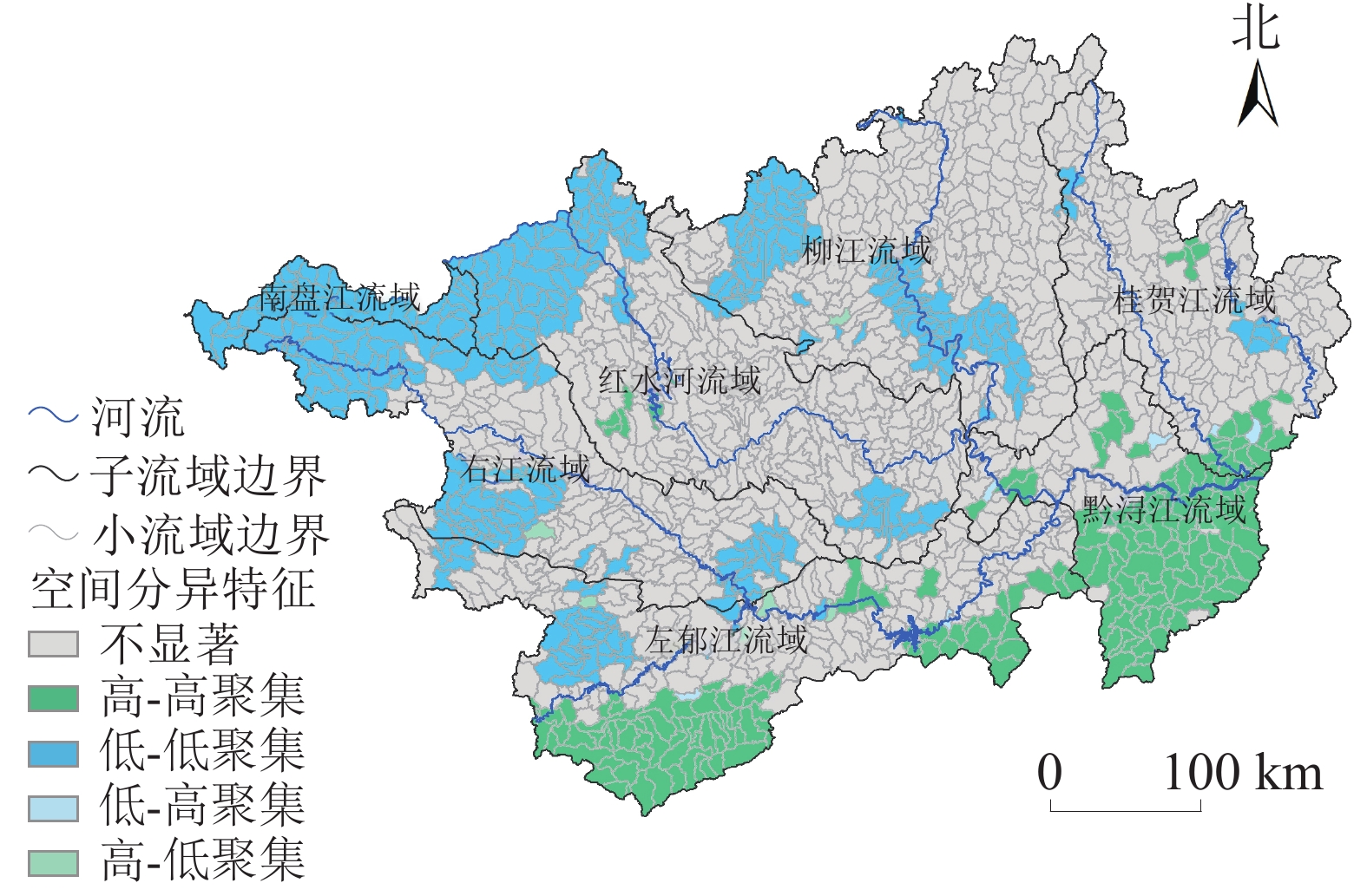
局域自相关性(图4)分析表明:广西西江流域水源涵养服务以低-低聚集和高-高聚集类型为主,这2种类型区面积所占比例分别为21.08%和13.56%,低-低聚集类型主要分布在南盘江流域、右江流域、红水河流域和柳江流域内等,而高-高聚集类型主要分布在左江及郁江流域南部,以及黔江和浔江东南部。低-高聚集类型和高-低聚集类型面积所占比例均较小,分别为0.25%和0.29%。水源涵养服务在流域内剩余的64.82%区域空间聚集类型不显著。
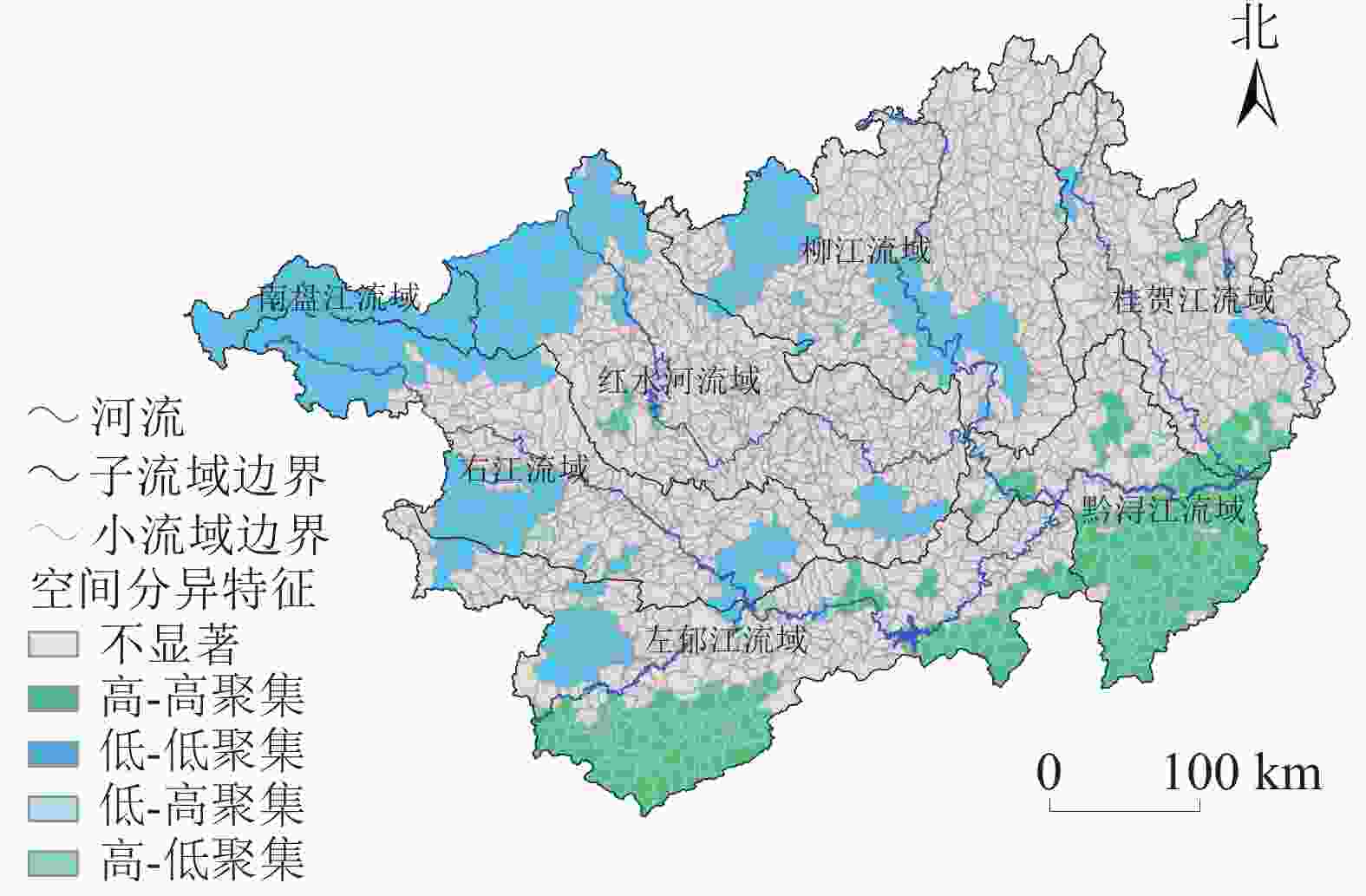
图 4 广西西江流域水源涵养服务空间分异特征示意图
Figure 4. Spatial variation characteristic of water retention service in Xijiang River Basin of Guangxi
-
在GeoDa中使用OLS检验13项因子对水源涵养服务的影响,使用逐步回归方法筛选出对水源涵养量影响显著且各自变量之间多重共线性统计量<30的因子组合,用于空间模型分析。最终筛选出土壤饱和导水率、降水量、植被净初级生产力、坡度、人口密度、经济密度及不透水率7个因子。由表1所示:OLS检验拟合优度R2为0.853,多重共线性统计量<30,残差莫兰指数为0.597,P为0.000,说明OLS模型回归后的残差存在明显的空间依赖性,则必须剔除OLS模型回归后残差中的空间依赖性因素,即使用空间回归模型进行影响因素分析。根据LM检验以及稳健性的LM检验结果,本研究最终选择空间误差模型(SEM)进行分析。SEM是指模型的误差项导致了空间变量之间的相关性,变量之间的空间相互作用存在于误差项。
表 1 基于空间计量模型的水源涵养服务影响因素分析
Table 1. Influencing factors of water retention service based on spatial econometric model
变量 最小二乘法回归(OLS) 空间误差模型(SEM) 回归系数 P 回归系数 P 常数项 −510.200 0.000 −490.920 0.000 土壤饱和导水率 1.772 0.000 1.649 0.000 多年平均降水量 0.270 0.000 0.267 0.000 植被净初级生产力 0.094 0.000 0.086 0.000 坡度 3.401 0.000 3.185 0.000 不透水率 −0.910 0.001 −0.973 0.000 人口密度 −0.101 0.000 −0.033 0.021 经济密度 0.012 0.000 0.004 0.006 空间自相关系数 0.780 0.000 对数似然值 −7 353.870 −6 863.070 赤池信息准则 14 723.700 13 742.100 施瓦兹准则 14 765.900 13 784.300 拟合优度R2 0.853 0.939 根据SEM结果(表1),模型拟合优度R2为0.939,显示出SEM拟合效果更优。SEM模拟结果中各因子的回归系数均有所改变,消除了由地域空间自相关带来的空间误差影响,使得模型更加稳健和准确。表1所示:土壤饱和导水率、多年平均降水量、坡度、植被净初级生产力、经济密度与水源涵养的系数均为正数,P均小于0.01,说明这些因素的提高均能极显著地增加生态系统水源涵养服务;而人口密度和不透水率的回归系数均为负值,P均小于0.05,说明随着人口密度、不透水率的增加均能显著地降低生态系统水源涵养服务。空间自相关系数在统计上也极显著,说明误差项存在空间依懒性。从回归系数看,土壤饱和导水率、多年平均降水量、坡度以及不透水率是水源涵养服务的主要影响因素。
-
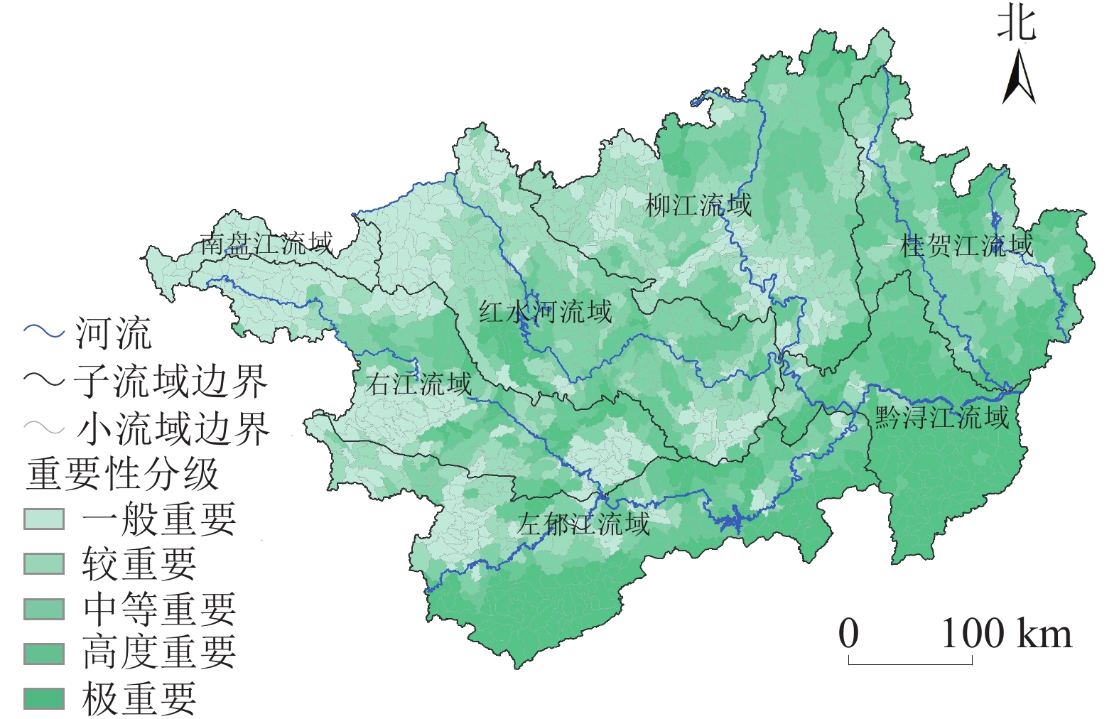
在ArcGIS软件中采用分位数分类法进行水源涵养服务重要性分级[28]。按水源涵养量相对值由低到高依次分为5个重要性等级,即一般重要、较重要、中度重要、高度重要、极重要(表2)。根据重要性分级评价结果,将极重要区和高度重要区划定为水源涵养服务重要区。
表 2 水源涵养服务重要性分级标准
Table 2. Importance classification standard of water retention service
重要性分级 水源涵养服务/mm 一般 33.61~101.35 较重要 101.35~135.21 中度重要 135.21~174.29 高度重要 174.29~252.44 极重要 252.44~697.91 图5显示:研究区水源涵养服务极重要区面积占全流域的19.78%,集中分布在黔浔江流域以及左郁江流域南部地区,在其他子流域内呈现少量零星分布;除南盘江流域之外,水源涵养服务高度重要区(面积占比19.95%)在各子流域内均有分布,其分布较为分散,但紧密围绕在极重要区周边;水源涵养服务中等重要区(面积占比20.18%)主要分布在右江流域、红水河流域中游、柳江流域东北部和桂贺江流域内,零星分布在左郁江流域内;水源涵养服务较重要区(面积占比20.02%)主要分布在红水河流域上游、柳江流域西南部,零星分布在左郁江、右江和桂贺江流域内;水源涵养服务一般重要区(面积占比20.07%)主要分布在南盘江流域、右江流域、红水河流域上游、柳江流域西南部和左郁江流域北部。上述水源涵养高度重要区和极重要区作为广西西江流域水源涵养服务重要区,在制定水资源利用、生态保护等政策与规划时,是重点和优先保护的区域。
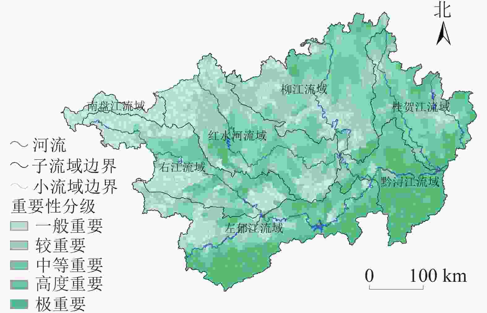
图 5 广西西江流域水源涵养服务重要性分级空间分布示意图
Figure 5. Spatial distribution of water retention service importance in Xijiang River Basin of Guangxi
-
广西西江小流域多年平均水源涵养量平均为185.36 mm,2015年水源涵养总量为376.10亿 m3,占多年平均产水量的23.90%。研究区水源涵养服务呈明显的空间差异,表现为由西北向东南逐渐增加的趋势,在空间分布上呈现聚集分布,并以低-低聚集和高-高聚集类型为主。土壤饱和导水率、多年平均降水量、坡度以及不透水率是水源涵养服务的主要影响因素。
-
本研究发现自然因素中土壤饱和导水率、降水量和植被净初级生产力与水源涵养服务呈正相关,且影响较为显著,这与宁亚洲等[13]的研究结果一致,说明降水量越高,植被越茂密,越有利于形成良好的土壤结构,进而促进土壤持水能力,提高水源涵养服务。本研究中,社会经济因素对水源涵养服务具有显著影响,但影响程度较弱。其中,人口密度与水源涵养服务呈负相关,这与柳冬青等[3]、龚诗涵等[10]、顾铮鸣等[11]的研究结果相吻合;而经济密度与水源涵养服务呈正相关,这与龚诗涵等[10]和顾铮鸣等[11]的研究结果存在差异,可能与研究区经济密度差异程度有关。
水源涵养服务空间定量化评估以及重要性分级是区域水资源利用、分区管理与综合保护的基础,在实际应用中评估结果的准确性是首先需要考虑的。本研究模型的简化以及缺少野外长期实测数据,增加了研究结果的不确定性,应在以下方向继续研究:①加强野外观测,获取长期实测数据,进一步完善参数本地化工作以提高结果准确性;②目前模型结果的验证多使用研究区水资源公报数据或水文站实际径流数据来进行产水量结果的验证,但现实中难以获取流域水源涵养服务实际监测数据进行结果验证,常用的综合蓄水法实测的是水源涵养潜在能力,如何区分流域水源涵养潜在能力与实际提供的水源涵养服务是将来评估的关键问题。
-
本研究得到了北部湾环境演变与资源利用教育部重点实验室、广西地表过程与智能模拟重点实验室系统基金项目(GTEU-KLOP-X1708)、广西高校中青年教师基础能力提升项目(2018KY0360)和广西高校大学生创新创业计划(20180603286)的支持,在此表示感谢。感谢审稿专家与编辑老师对本文提出了建设性修改意见!
Spatial pattern and its influencing factors of water conservation services in Xijiang River Basin, Guangxi
-
摘要:
目的 水源涵养在众多生态系统服务中占据着重要的地位。揭示水源涵养服务空间格局及其影响因素,识别水源涵养服务重要区,对流域水资源利用、分区管理与综合保护具有重要意义。 方法 以广西西江流域为研究对象,基于InVEST模型、GeoDa与ArcGIS等工具,使用全域和局域空间自相关检验研究区水源涵养服务空间分布模式,构建空间误差模型辨识水源涵养服务关键影响因素,采用分位数分类法进行水源涵养服务重要性分级。 结果 广西西江流域多年平均水源涵养量为185.36 mm,2015年总量为376.10亿 m3。全域莫兰指数为0.769,表明研究区水源涵养服务在空间分布上具有空间依赖性。考虑到多重共线性的影响,最终从13项影响因素中筛选出7项进入空间误差模型,得出土壤饱和导水率、多年平均降水量、坡度、植被净初级生产力、经济密度对水源涵养服务产生显著正面影响,而人口密度和不透水率对水源涵养服务产生显著负面影响。识别出黔浔江流域及左郁江流域南部区域是水源涵养服务重要区,在相关政策制定与管理决策中需重点和优先考虑。 结论 广西西江流域水源涵养服务在空间分布上呈现集聚分布,并以低-低聚集和高-高聚集类型为主。土壤饱和导水率、多年平均降水量、坡度以及不透水率是水源涵养服务最主要的影响因素。图5表2参28 Abstract:Objective Water conservation plays an important role in ecosystem services. This study aims to reveal the spatial pattern and its influencing factors of water conservation services and identify the important areas of water conservation services, which is of great significance to utilization, regional management and comprehensive protection of water resources in the basin. Method Taking Xijiang River Basin in Guangxi as the research object, with the support of the InVEST model, GeoDa, ArcGIS and other tools, the spatial pattern of water conservation services in the research area was tested by using global and local spatial autocorrelation, and the spatial error model was constructed to identify the key factors affecting water conservation services. Quantile classification method was used to classify the importance of water conservation services. Result The average annual water conservation capacity of Xijiang River Basin in Guangxi was 185.36 mm, with a total water amount of 37.61 billion m3 in 2015. The global Moran index was 0.769, indicating that the spatial distribution of water conservation services in the study area was spatially dependent. Considering the influence of multicollinearity, 7 of the 13 influencing factors were finally selected into the spatial error model. The results showed that soil saturated hydraulic conductivity, annual average precipitation, slope, net primary productivity of vegetation (NPP) and economic density had significant positive effects on water conservation services, while population density and impervious surface rate had significant negative impacts on water conservation services. Qianxunjiang River Basin and the southern region of Zuoyujiang River Basin were identified as important areas for water conservation services, which should be prioritized in relevant policy making and management decision. Conclusion The spatial distribution of water conservation services in Xijiang River Basin in Guangxi presents a clustering distribution, dominated by low-low aggregation and high-high aggregation types. Soil saturated hydraulic conductivity, annual average precipitation, slope and impervious surface rate are the main factors affecting water conservation services. [Ch, 5 fig. 2 tab. 28 ref.] -
图 1 广西西江流域水源涵养服务空间分布示意图
Figure 1 Spatial distribution of water retention service in Xijiang River Basin of Guangxi
图 2 广西西江流域多年平均降水量(A)与实际蒸散发(B)空间分布示意图
Figure 2 Spatial distribution of average annual precipitation (A) and actual evapotranspiration (B) in Xijiang River Basin of Guangxi
图 3 广西西江流域土壤饱和导水率空间分布示意图
Figure 3 Spatial distribution of soil saturated hydraulic conductivity in Xijiang River Basin of Guangxi
图 4 广西西江流域水源涵养服务空间分异特征示意图
Figure 4 Spatial variation characteristic of water retention service in Xijiang River Basin of Guangxi
图 5 广西西江流域水源涵养服务重要性分级空间分布示意图
Figure 5 Spatial distribution of water retention service importance in Xijiang River Basin of Guangxi
表 1 基于空间计量模型的水源涵养服务影响因素分析
Table 1. Influencing factors of water retention service based on spatial econometric model
变量 最小二乘法回归(OLS) 空间误差模型(SEM) 回归系数 P 回归系数 P 常数项 −510.200 0.000 −490.920 0.000 土壤饱和导水率 1.772 0.000 1.649 0.000 多年平均降水量 0.270 0.000 0.267 0.000 植被净初级生产力 0.094 0.000 0.086 0.000 坡度 3.401 0.000 3.185 0.000 不透水率 −0.910 0.001 −0.973 0.000 人口密度 −0.101 0.000 −0.033 0.021 经济密度 0.012 0.000 0.004 0.006 空间自相关系数 0.780 0.000 对数似然值 −7 353.870 −6 863.070 赤池信息准则 14 723.700 13 742.100 施瓦兹准则 14 765.900 13 784.300 拟合优度R2 0.853 0.939  下载: 导出CSV
表 2 水源涵养服务重要性分级标准
Table 2. Importance classification standard of water retention service
重要性分级 水源涵养服务/mm 一般 33.61~101.35 较重要 101.35~135.21 中度重要 135.21~174.29 高度重要 174.29~252.44 极重要 252.44~697.91
下载: 导出CSV
-
[1] WU Jianguo. Landscape sustainability science: ecosystem services and human wellbeing in changing landscape [J]. Landscape Ecol, 2013, 28: 999 − 1023. [2] 李双成, 刘金龙, 张才玉, 等. 生态系统服务研究动态及地理学研究范式[J]. 地理学报, 2011, 66(12): 1618 − 1630. LI Shuangcheng, LIU Jinlong, ZHANG Caiyu, et al. The research trends of ecosystem services and the paradigm in geography [J]. Acta Geogr Sin, 2011, 66(12): 1618 − 1630. [3] 柳冬青, 曹二佳, 张金茜, 等. 甘肃白龙江流域水源涵养服务时空格局及其影响因素[J]. 自然资源学报, 2020, 35(7): 1728 − 1743. LIU Dongqing, CAO Ergui, ZHANG Jinxi, et al. Spatiotemporal pattern of water conservation and its influencing factors in Bailongjiang Watershed of Gansu [J]. J Nat Resour, 2020, 35(7): 1728 − 1743. [4] 刘菊, 傅斌, 张成虎, 等. 基于InVEST模型的岷江上游生态系统水源涵养量与价值评估[J]. 长江流域资源与环境, 2019, 28(3): 577 − 585. LIU Ju, FU Bin, ZHANG Chenghu, et al. Assessment of ecosystem water retention and its value in the upper reaches of Minjiang River based on InVEST model [J]. Resour Environ Yangtza Basin, 2019, 28(3): 577 − 585. [5] PETUS C, DEVLIN M, da SILVA E T, et al. Defining wet season water quality target concentrations for ecosystem conservation using empirical light attenuation models: a case study in the Great Barrier Reef (Australia) [J]. J Environ Manage, 2018, 213: 451 − 466. [6] HOYER R, CHANG H. Assessment of freshwater ecosystem services in the Tualatin and Yamhill basins under climate change and urbanization [J]. Appl Geogr, 2014, 53: 402 − 416. [7] PESSACG N, FLAHERTY S, BRANDIZI L, et al. Getting water right: a case study in water yield modelling based on precipitation data [J]. Sci Total Environ, 2015, 537: 225 − 234. [8] MELAKU N D, RENSCHLER C S, HOLZMANN H, et al. Prediction of soil and water conservation structure impacts on runoff and erosion processes using SWAT model in the northern Ethiopian highlands [J]. J Soils Sediments, 2018, 18(4): 1743 − 1755. [9] SEKA A M, MOHAMMED A K. Evaluation of impacts of soil and water conservation on watershed hydrology of Kulfo River using hydrologic SWAT models [J]. Int J Sci Eng Res, 2016, 7(8): 2087 − 2092. [10] 龚诗涵, 肖洋, 郑华, 等. 中国生态系统水源涵养空间特征及其影响因素[J]. 生态学报, 2017, 37(7): 2455 − 2462. GONG Shihan, XIAO Yang, ZHENG Hua, et al. Spatial patterns of ecosystem water conservation in China and its impact factors analysis [J]. Acta Ecol Sin, 2017, 37(7): 2455 − 2462. [11] 顾铮鸣, 金晓斌, 沈春竹, 等. 近15 a江苏省水源涵养功能时空变化与影响因素探析[J]. 长江流域资源与环境, 2018, 27(11): 2453 − 2462. GU Zhengming, JIN Xiaobin, SHEN Chunzhu, et al. Variation and influence factors of water conservation service function in Jiangsu Province from 2000 to 2015 [J]. Resour Environ Yangtza Basin, 2018, 27(11): 2453 − 2462. [12] 陈姗姗, 刘康, 包玉斌, 等. 商洛市水源涵养服务功能空间格局与影响因素[J]. 地理科学, 2016, 36(10): 1546 − 1554. CHEN Shanshan, LIU Kang, BAO Yubin, et al. Spatial pattern and influencing factors of water conservation service function in Shangluo City [J]. Sci Geogr Sin, 2016, 36(10): 1546 − 1554. [13] 宁亚洲, 张福平, 冯起, 等. 秦岭水源涵养功能时空变化及其影响因素[J]. 生态学杂志, 2020, 39(9): 3080 − 3091. NING Yazhou, ZHANG Fuping, FENG Qi, et al. Temporal and spatial variation of water conservation function in Qinling Mountain and its influencing factors [J]. Chin J Ecol, 2020, 39(9): 3080 − 3091. [14] 张佳田, 焦文献, 韩宝龙. 城镇化与生态系统服务的协调演化特征及空间耦合关系[J]. 生态学报, 2020, 40(10): 3271 − 3282. ZHANG Jiatian, JIAO Wenxian, HAN Baolong. Characteristics of coordination changes and spatial coupling relationship between urbanization and ecosystem services [J]. Acta Ecol Sin, 2020, 40(10): 3271 − 3282. [15] 梁晓瑶, 袁丽华, 宁立新, 等. 基于InVEST模型的黑龙江省生境质量空间格局及其影响因素[J]. 北京师范大学学报(自然科学版), 2020, 56(6): 864 − 872. LIANG Xiaoyao, YUAN Lihua, NING Lixin, et al. Spatial pattern of habitat quality and driving factors in Heilongjiang Province [J]. J Beijing Norm Univ Nat Sci, 2020, 56(6): 864 − 872. [16] 赵育恒, 曾晨. 武汉城市圈生态服务价值时空演变分析及影响因素[J]. 生态学报, 2019, 39(4): 1426 − 1440. ZHAO Yuheng, ZENG Chen. Analysis of spatial-temporal evolution and factors that influences ecological service values in Wuhan Urban Agglomeration, China [J]. Acta Ecol Sin, 2019, 39(4): 1426 − 1440. [17] 荣检, 胡宝清, 闫妍. 广西西江流域植被净初级生产力时空分布特征及其影响因素[J]. 生态学杂志, 2017, 36(4): 1020 − 1028. RONG Jian, HU Baoqing, YAN Yan. Spatial-temporal distribution and its influencing factors of vegetation net primary productivity in Guangxi Xijiang River basin [J]. Chin J Ecol, 2017, 36(4): 1020 − 1028. [18] 余新晓, 周彬, 吕锡芝, 等. 基于InVEST模型的北京山区森林水源涵养功能评估[J]. 林业科学, 2012, 48(10): 1 − 5. YU Xinxiao, ZHOU Bin, LÜ Xizhi, et al. Evaluation of water conservation function in mountain forest areas of Beijing based on InVEST model [J]. Sci Silv Sin, 2012, 48(10): 1 − 5. [19] 杨霞, 贾尔恒·阿哈提, 邱秀云, 等. 乌伦古河流域SWAT模型基础数据库构建[J]. 水资源与水工程学报, 2013, 24(6): 74 − 78. YANG Xia, Jiaerheng Ahati, QIU Xiuyun, et al. Construction of basic database for SWAT model in Wulungu River basin [J]. J Water Resour Water Eng, 2013, 24(6): 74 − 78. [20] 李磊, 董晓华, 喻丹, 等. 基于SWAT模型的清江流域径流模拟研究[J]. 人民长江, 2013, 44(22): 25 − 29, 42. LI Lei, DONG Xiaohua, YU Dan, et al. Study on runoff simulations on Qingjiang River Basin by SWAT model [J]. Yangtze River, 2013, 44(22): 25 − 29, 42. [21] 姜磊. 应用空间计量经济学[M]. 北京: 中国人民大学出版社, 2020. JIANG Lei. Applied Spatial Econometrics[M]. Beijing: China Renmin University Press, 2020. [22] 姜广辉, 何新, 马雯秋, 等. 基于空间自相关的农村居民点空间格局演变及其分区[J]. 农业工程学报, 2015, 31(13): 265 − 273. JIANG Guanghui, HE Xin, MA Wenqiu, et al. Rural settlements spatial pattern evolution and zoning district based on spatial autocorrelation [J]. Trans Chin Soc Agric Eng, 2015, 31(13): 265 − 273. [23] 王劲峰, 廖一兰, 刘鑫. 空间数据分析教程[M]. 2版. 北京: 科学出版社, 2019. WANG Jinfeng, LIAO Yilan, LIU Xin. Spatial Data Analysis Tutorial [M]. 2nd ed. Beijing: Science Press, 2019. [24] 高歌, 陈德亮, 任国玉, 等. 1956—2000年中国潜在蒸散量变化趋势[J]. 地理研究, 2006, 25(3): 378 − 387. GAO Ge, CHEN Deliang, REN Guoyu, et al. Trend of potential evapotranspiration over China during 1956 to 2000 [J]. Geogr Res, 2006, 25(3): 378 − 387. [25] CANADELL J, JACKSON R B, EHLERINGER J B, et al. Maximum rooting depth of vegetation types at the global scale [J]. Oecologia, 1996, 108(4): 583 − 595. [26] 傅斌, 徐佩, 王玉宽, 等. 都江堰市水源涵养功能空间格局[J]. 生态学报, 2013, 33(3): 789 − 797. FU Bin, XU Pei, WANG Yukuan, et al. Spatial pattern of water retetnion in Dujiangyan County [J]. Acta Ecol Sin, 2013, 33(3): 789 − 797. [27] 范亚宁, 刘康, 陈姗姗, 等. 秦岭北麓陆地生态系统水源涵养功能的空间格局[J]. 水土保持通报, 2017, 37(2): 50 − 56. FAN Yaning, LIU Kang, CHEN Shanshan, et al. Spatial pattern analysis on water conservative functionality of land ecosystem in northern slope of Qinling Mountains [J]. Bull Soil Water Conserv, 2017, 37(2): 50 − 56. [28] 包玉斌, 李婷, 柳辉, 等. 基于InVEST模型的陕北黄土高原水源涵养功能时空变化[J]. 地理研究, 2016, 35(4): 664 − 676. BAO Yubin, LI Ting, LIU Hui, et al. Spatial and temporal changes of water conservation of Loess Plateauin northern Shaanxi Province by InVEST model [J]. Geogr Res, 2016, 35(4): 664 − 676. -

-
链接本文:
https://zlxb.zafu.edu.cn/article/doi/10.11833/j.issn.2095-0756.20210616
 点击查看大图
计量
- 文章访问数: 1854
- HTML全文浏览量: 546
- PDF下载量: 89
- 被引次数: 0


