Volume 40 Issue 6
Nov.  2023
Turn off MathJax
Article Contents

LI Jiahao, LIU Yuguo, ZHAO Ziqing, ZHOU Yining, XU Zihan, CHEN Xinjun, CUI Ming. Temporal and spatial dynamic monitoring of land desertification and landscape pattern evolution characteristics in the Xiaoluan River Basin[J]. Journal of Zhejiang A&F University, 2023, 40(6): 1322-1332. doi: 10.11833/j.issn.2095-0756.20220731
Citation: LI Jiahao, LIU Yuguo, ZHAO Ziqing, ZHOU Yining, XU Zihan, CHEN Xinjun, CUI Ming. Temporal and spatial dynamic monitoring of land desertification and landscape pattern evolution characteristics in the Xiaoluan River Basin[J]. Journal of Zhejiang A&F University, 2023, 40(6): 1322-1332. doi: 10.11833/j.issn.2095-0756.20220731

Temporal and spatial dynamic monitoring of land desertification and landscape pattern evolution characteristics in the Xiaoluan River Basin

doi: 10.11833/j.issn.2095-0756.20220731
  • Received Date: 2022-11-28
  • Rev Recd Date: 2023-05-18
  • Available Online: 2023-11-23
  • Publish Date: 2023-11-23
  •   Objective  This study, with an investigation of the process of land desertification changes in the Xiaoluanhe River Basin in Weichang Manchu and Mongolian Autonomous County (Weichang County) of Hebei Province, a typical agricultural-pastoral interlacing zone suffering from a serious problem of land desertification, is aimed to understand the influence of land use changes and elevation on land desertification so as to provide a theoretical basis for the prevention and control of land desertification in the basin and the comprehensive management of mountains, water, forests, lakes, grasses and sands.   Method  First, Google Earth Engine and ArcGIS platform was utilized to analyse the Landsat series remote sensing data in 2000, 2010 and 2020. Then, the normalized difference vegetation index (NDVI) and surface albedo feature space were constructed to establish the desertification difference index (DDI) model and classify the sandy land in the degree of desertification.   Result  The past 20 years has witnessed an overall improvement trend in the land of Xiaoluanhe River Basin with the land area of extremely severe and severe desertification decreased by nearly 80% and 56% respectively and light desertification and non-desertification land accounting for about 65% of the basin area. The improvement rate of desertification land decreased in the later stage, and the improved area was concentrated in Saihanba Forest Farm and the lower reaches of Xiaoluanhe River. The desertification landscape in the river basin tended to be concentrated with the degree of landscape fragmentation continuing to decrease. There was an obvious improvement on the desertification for woodland and grassland and the desertification tended to decrease with the increase of altitude.   Conclusion  Since 2000, the land in the Xiaoluanhe River Basin has improved as a whole in terms of desertification whereas there is a trend of deterioration of land in areas such as the town of Yudaokou and the pastures. Therefore, it is necessary to strengthen measures in the conduct of precision sand control so as to deal with the desertification in the river basin and eventually realize the sustainable development of the Xiaoluanhe River Basin. [Ch, 6 fig. 4 tab. 34 ref.]
  • [1] CHEN Xi, YE Kemo, LI Kun, JIN Yang.  Research on land use change and risk-value of “production-living-ecological space” in a resource-based city . Journal of Zhejiang A&F University, 2023, 40(5): 1111-1120. doi: 10.11833/j.issn.2095-0756.20220666
    [2] ZUO Qilin, YU Yang, ZHA Tonggang, ZHANG Hengshuo, LIANG Yipeng, OUYANG Jiahuan.  Soil quality assessment of different land use types in Qingshui River Basin of western Shanxi Province . Journal of Zhejiang A&F University, 2023, 40(4): 801-810. doi: 10.11833/j.issn.2095-0756.20220498
    [3] ZHANG Chenghu, LIU Ju, HU Baoqing, CHEN Xiufen.  Spatial pattern and its influencing factors of water conservation services in Xijiang River Basin, Guangxi . Journal of Zhejiang A&F University, 2022, 39(5): 1104-1113. doi: 10.11833/j.issn.2095-0756.20210616
    [4] ZHANG Yilin, LI Gongquan, LIU Ying.  Spatial distribution of endangered orchids in the Yangtze River Watershed . Journal of Zhejiang A&F University, 2022, 39(4): 750-757. doi: 10.11833/j.issn.2095-0756.20210551
    [5] WU Yuchen, LIN Fang, ZHANG Jiayang, ZHANG Lulu.  Effects of single/mixed sowing of three medicinal plants on the contents of carbon, nitrogen and enzymes activities of sandy soil . Journal of Zhejiang A&F University, 2021, 38(2): 329-335. doi: 10.11833/j.issn.2095-0756.20200486
    [6] GUO Hongyang, SHI Mingchang, YANG Jianying, CHEN Chunyang.  Precise spatial distribution of suitability of Pinus tabulaeformis in Daqing River Basin, Baiyangdian . Journal of Zhejiang A&F University, 2021, 38(6): 1100-1108. doi: 10.11833/j.issn.2095-0756.20200599
    [7] OU Shengye, DING Li, YU Ninger, WU Shengchun, LIANG Peng.  Application of Bos grunniens waste on nutrient leaching reduction for the desertified soil . Journal of Zhejiang A&F University, 2020, 37(6): 1088-1096. doi: 10.11833/j.issn.2095-0756.20190703
    [8] LIN Fang.  Microbial biomass and enzymatic activity in sandy soils of northern Henan Province with different alfalfa and awnless brome cultivating patterns . Journal of Zhejiang A&F University, 2019, 36(3): 590-597. doi: 10.11833/j.issn.2095-0756.2019.03.021
    [9] LI Hualin, GAO Huaduan, YANG Tao, GAO Ruxue, SUN Quanzhong.  Sediment reduction with different vegetation types for the Kaizhang small watershed in a karst area . Journal of Zhejiang A&F University, 2017, 34(4): 687-694. doi: 10.11833/j.issn.2095-0756.2017.04.015
    [10] WANG Xiaoxue, LIN Tianmiao, WU Xiuqin.  The impact of land use/land cover changes on human settlements in sandylands . Journal of Zhejiang A&F University, 2014, 31(1): 111-116. doi: 10.11833/j.issn.2095-0756.2014.01.017
    [11] ZHANG Tao, LI Yongfu, JIANG Peikun, ZHOU Guomo, LIU Juan.  Research progresses in the effect of land-use change on soil carbon pools and soil respiration . Journal of Zhejiang A&F University, 2013, 30(3): 428-437. doi: 10.11833/j.issn.2095-0756.2013.03.021
    [12] WANG Yu-lan, LIU Ai-hua, ZHANG Jing-wen, ZHAO Bian-jian, YUE Zhao-yang, ZHANG Xin-ping, TANG Li.  Coincidence level in spatial distribution of Eulecanium gigantea and Blastothrix sericae . Journal of Zhejiang A&F University, 2012, 29(5): 799-802. doi: 10.11833/j.issn.2095-0756.2012.05.026
    [13] SUN Wei, HOU Rui-xia, TANG Xiao-ming.  Desertification and sandification monitoring information management and application services system architecture . Journal of Zhejiang A&F University, 2012, 29(6): 930-938. doi: 10.11833/j.issn.2095-0756.2012.06.019
    [14] LI Ya-ni, WANG Wen-qiang, LIAN Zhen-min.  Edge effects of grasshopper communities in the North-Luo River Valley of Yan’an . Journal of Zhejiang A&F University, 2011, 28(2): 275-279. doi: 10.11833/j.issn.2095-0756.2011.02.017
    [15] LIU Xi-jun, WU Ze-min, HUANG Qing-feng.  Patch characteristics of forest landscape element for Xiaokeng Small Watershed,Laoshan Nature Reserve,Anhui Province . Journal of Zhejiang A&F University, 2010, 27(2): 190-197. doi: 10.11833/j.issn.2095-0756.2010.02.005
    [16] GU Li-ping, GUO Yong-qing, LANG Nan-jun, YANG Xu, ZE Sang-zi, LI Jiang, RUAN Hong-hua, GU Xiao-ping.  Carbon density and allocation in young Jatropha curcas stands of the Honghe Region,Yunnan Province . Journal of Zhejiang A&F University, 2010, 27(5): 671-676. doi: 10.11833/j.issn.2095-0756.2010.05.006
    [17] WANG Dong-yun, ZHANG Zhuo-wen, SU Kai-jun, WANG Guang, LEI Yun-fei, LIN Ming-lei, ZHANG Pei, ZHONG Yong.  Hydrology of Phyllostachys pubescens in Liuxihe,Guangdong Province . Journal of Zhejiang A&F University, 2008, 25(1): 37-41.
    [18] CAO Yin-gui, ZHOU Wei, CHENG Ye, XU Ning, HAO Yin.  A review of land use and land cover changes in China . Journal of Zhejiang A&F University, 2007, 24(5): 633-637.
    [19] LONG Wu, YANG Yun-hua, WANG Ke-qin, LI Jian-zeng, LI Bao-rong, LI Yun-jiao.  Moisture-holding capacity of different plant cover types in the Jianshan River drainage area . Journal of Zhejiang A&F University, 2007, 24(2): 135-139.
    [20] Fang Zhigang, Mao Chaoming.  Spatial Distribution Patterns of the Larvae of Golden Larch Olethreutid Moth . Journal of Zhejiang A&F University, 1993, 10(2): 228-233.
  • [1]
    WANG Tao. Deserts and Aeolian Desertification in China [M]. Shijiazhuang: Hebei Science & Technology Press, 2003: 13 − 16.
    [2]
    XU Lingling, YAN Hao, QIAN Shuan. Spatio-temporal change of land desertification sensitivity in northern China from 2000 to 2018 based on MODIS-NDVI [J]. Journal of Natural Resources, 2020, 35(4): 925 − 936.
    [3]
    TU Zhifang, LI Mengxian, SUN Tao. The status and trend analysis of desertification and sandification [J]. Forest Resources Management, 2016(1): 1 − 5, 13.
    [4]
    WANG Xu, DIAO Zhaoyan, ZHENG Zhirong, et al. Temporal and spatial dynamics of desertification in adjacent steppe of China and Mongolia [J]. Research of Environmental Sciences, 2021, 34(12): 2935 − 2944.
    [5]
    WU Yingying, WANG Zhenting. Desertification sensitivity assessment in the middle and lower reaches of the Shule River Basin [J]. Journal of Desert Research, 2022, 42(4): 163 − 171.
    [6]
    WANG Yunxia, ZHANG Hong. Analysis on the dynamics of desertification risk based on improved dune mobility index in north Shanxi Province [J]. Journal of Arid Land Resources and Environment, 2019, 33(5): 95 − 100.
    [7]
    MENG Xiaoyu, GAO Xin, LI Sen, et al. Monitoring desertification in Mongolia based on landsat images and Google Earth Engine from 1990 to 2020 [J]. Ecological Indicators, 2021, 129(1): 107 − 908.
    [8]
    WEI Huaidong, GAO Zhihai, DING Feng. Research on desertification dynamic monitor in Minqin County [J]. Journal of Soil and Water Conservation, 2004, 18(2): 32 − 36.
    [9]
    XU Mengzhen, LI Yanfu, LI Zhiwei, et al. Relationship between the desertification risk index and blowing sand content of typical aeolian erosion in Sanjiangyuan [J]. Journal Tsinghua University (Science and Technology), 2017, 57(4): 337 − 344.
    [10]
    KUANG Qian, YUAN Quanzhi, HAN Jichong, et al. A remote sensing monitoring method for alpine grasslands desertification in the eastern Qinghai-Tibetan plateau [J]. Journal of Mountain Science, 2020, 17(6): 1423 − 1437.
    [11]
    ZHAO Wenbo, FENG Lili, ZHAO Anzhou, et al. Spatial and temporal evolution of desertification and its driving factors of climate in Hebei Province [J]. Bulletin of Soil and Water Conservation, 2020, 41(4): 252 − 259.
    [12]
    La Ba, Zhaxi Ouzhu, Baima Yangzong, et al. Study on remote sensing monitoring of desertification in Tibet based on MODIS data [J]. Meteorological and Environmental Sciences, 2019, 42(4): 39 − 46.
    [13]
    PAN Jinghu, QIN Xiaojuan. Extracting desertification from landsat imagey using a feature space composed of vegetation index and albedo: a case study of Zhangye oasis and its adjacent areas [J]. Science of Surveying and Mapping, 2010, 35(3): 93 − 95.
    [14]
    MA Zongyi, XIE Yaowen, JIAO Jizong, et al. The construction and application of an Aledo-NDVI based desertification monitoring model [J]. Procedia Environmental Sciences, 2011, 10: 2029 − 2035.
    [15]
    VOROVENCII I. Applying the change vector analysis technique to assess the desertification risk in the south-west of Romania in the period 1984−2011 [J/OL]. Environmental Monitoring & Assessment, 2017, 189(10): 524[2022-11-01]. doi:10.1007/s10661-017-6234-6.
    [16]
    WEI Haishuo, WANG Juanle, CHENG Kai, et al. Desertification information extraction based on feature space combinations on the Mongolian plateau [J/OL]. Remote Sensing, 2018, 10(10): 1614[2022-11-01]. doi: 10.3390/rs10101614.
    [17]
    GOU Fen, LIANG Wei, SUN Shaobo, et al. Analysis of the desertification dynamics of sandy lands in northern China over the period 2000−2017 [J]. Geocarto International, 2020, 36: 1938 − 1959.
    [18]
    LIU Xiaoxi, XIE Yunhu, HAI Chunxing. Study on land desertification in desert-oasis ecotone based on desertification difference Index [J]. Journal of Inner Mongolia Normal University (Natural Science Edition), 2020, 49(1): 59 − 67.
    [19]
    ZHANG Xiaoqian, WANG Bo, WANG Xiahui. The realizing route of ecological safety in pastoral areas based on mountains, rivers, forest, farmland, lakes, and grassland systemic treatment: take Yudaokou pasture as an example [J]. Environmental Protection, 2018, 46(8): 56 − 59.
    [20]
    JIA Shuangzhu. 3S-Based Analysis on Patterns and Driving Forces of Desertification Land in Typical Areas of Chengde [D]. Baoding: Hebei Agricultural University, 2018.
    [21]
    WANG Zhanliang, WEI Xiaofeng, WEI Hao, et al. The grain size characteristics of different sedimentary units and the effects of desertification in the Xiaoluan River basin in Bashang, Hebei [J]. Mineral Exploration, 2021, 12(4): 1000 − 1007.
    [22]
    GUO Mishan. Ecological Planning and Typical Project Design of Xiaoluanhe River in Weichang County, Hebei Province [D]. Beijing: Beijing Forestry University, 2016.
    [23]
    MENG Chunlei. Surface Albedo assimilation and its impact on surface radiation budget in Beijing [J]. Advances in Meteorology, 2020, 8: 312 − 451.
    [24]
    LIANG Shunlin. Narrowband to broadband conversions of land surface Albedo I Algorithms [J]. Remote Sensing of Environment, 2001, 76(2): 213 − 238.
    [25]
    ZENG Yongnian, XIANG Nanping, FENG Zhaodong, et al. Albedo-NDVI space and remote sensing synthesis index models for desertification monitoring [J]. Scientia Geographica Sinica, 2006, 26(1): 75 − 81.
    [26]
    MA Xiongde, FAN Limin, ZHANG Xiaotuan, et al. Dynamic change of land desertification and its driving mechanism in Yushenfu mining area based on remote sensing [J]. Journal of China Coal Society, 2016, 41(8): 2063 − 2070.
    [27]
    Li Jinya. Spatio-temporal Variations and its Driving Factors of the Grassland Sandy Desertification in the Horqin Sand Land Based on Remote Sensing [D]. Beijing: Chinese Academy of Agricultural Sciences, 2014.
    [28]
    WANG Fang, GE Quangsheng, WANG Shaowu, et al. A new estimation of urbanization's contribution to the warming trend in China [J]. Journal of Climate, 2015, 28(22): 8923 − 8938.
    [29]
    LIN Guomin, CAI Hong, KANG Wenhua, et al. The study on dynamic change of the hillsides landscape feature in the middle and upper reaches of Chishui River [J]. Ecological Science, 2019, 38(5): 151 − 159.
    [30]
    WU Jianguo. Landscape Ecology Pattern, Process, Scale and Hierarchy [M]. Beijing: Higher Education Press, 2000.
    [31]
    HAN Lanying, ZHANG Zhengcai, ZHANG Qiang, et al. Desertification assessments in the Hexi corridor of northern China’s Gansu Province by remote sensing [J]. Natural Hazards, 2015, 75(3): 2715 − 2731.
    [32]
    ZHOU Zhiyong. Change in temporal-spatial pattern of vegetation coverage in Weichang County based on landsat remote sensing image [J]. Hydrogeology & Engineering Geology, 2020, 47(6): 81 − 90.
    [33]
    PENG Bo. Study on the Influence of Land Use Pattern on Desertification Degree in the Desertification Area of Bashang, Hebei Province [D]. Baoding: Hebei Agricultural University, 2019.
    [34]
    WANG Bo, WANG Xiahui. Promote the demonstration project of ecological protection and restoration of mountains, rivers, forests, farmland and lakes implementation and improve its effectiveness, based on Weichang County, Hebei Province [J]. Environment and Sustainable Development, 2017, 42(4): 11 − 14.
  • 加载中
通讯作者: 陈斌, bchen63@163.com
  • 1. 

    沈阳化工大学材料科学与工程学院 沈阳 110142

  1. 本站搜索
  2. 百度学术搜索
  3. 万方数据库搜索
  4. CNKI搜索

Figures(6)  / Tables(4)

Article views(232) PDF downloads(28) Cited by()

Related
Proportional views

Temporal and spatial dynamic monitoring of land desertification and landscape pattern evolution characteristics in the Xiaoluan River Basin

doi: 10.11833/j.issn.2095-0756.20220731

Abstract:   Objective  This study, with an investigation of the process of land desertification changes in the Xiaoluanhe River Basin in Weichang Manchu and Mongolian Autonomous County (Weichang County) of Hebei Province, a typical agricultural-pastoral interlacing zone suffering from a serious problem of land desertification, is aimed to understand the influence of land use changes and elevation on land desertification so as to provide a theoretical basis for the prevention and control of land desertification in the basin and the comprehensive management of mountains, water, forests, lakes, grasses and sands.   Method  First, Google Earth Engine and ArcGIS platform was utilized to analyse the Landsat series remote sensing data in 2000, 2010 and 2020. Then, the normalized difference vegetation index (NDVI) and surface albedo feature space were constructed to establish the desertification difference index (DDI) model and classify the sandy land in the degree of desertification.   Result  The past 20 years has witnessed an overall improvement trend in the land of Xiaoluanhe River Basin with the land area of extremely severe and severe desertification decreased by nearly 80% and 56% respectively and light desertification and non-desertification land accounting for about 65% of the basin area. The improvement rate of desertification land decreased in the later stage, and the improved area was concentrated in Saihanba Forest Farm and the lower reaches of Xiaoluanhe River. The desertification landscape in the river basin tended to be concentrated with the degree of landscape fragmentation continuing to decrease. There was an obvious improvement on the desertification for woodland and grassland and the desertification tended to decrease with the increase of altitude.   Conclusion  Since 2000, the land in the Xiaoluanhe River Basin has improved as a whole in terms of desertification whereas there is a trend of deterioration of land in areas such as the town of Yudaokou and the pastures. Therefore, it is necessary to strengthen measures in the conduct of precision sand control so as to deal with the desertification in the river basin and eventually realize the sustainable development of the Xiaoluanhe River Basin. [Ch, 6 fig. 4 tab. 34 ref.]

LI Jiahao, LIU Yuguo, ZHAO Ziqing, ZHOU Yining, XU Zihan, CHEN Xinjun, CUI Ming. Temporal and spatial dynamic monitoring of land desertification and landscape pattern evolution characteristics in the Xiaoluan River Basin[J]. Journal of Zhejiang A&F University, 2023, 40(6): 1322-1332. doi: 10.11833/j.issn.2095-0756.20220731
Citation: LI Jiahao, LIU Yuguo, ZHAO Ziqing, ZHOU Yining, XU Zihan, CHEN Xinjun, CUI Ming. Temporal and spatial dynamic monitoring of land desertification and landscape pattern evolution characteristics in the Xiaoluan River Basin[J]. Journal of Zhejiang A&F University, 2023, 40(6): 1322-1332. doi: 10.11833/j.issn.2095-0756.20220731
  • 土地沙化是指在干旱、半干旱及部分湿润地区,由于恶劣的自然条件或不合理的人类活动破坏生态平衡,导致地表发生土地退化的现象[12]。中国是世界上土地沙化最严重的国家之一,沙化土地面积基数大,分布范围广。其中,北方农牧交错带作为沙化最为严重的地区之一,是土地沙化防治的重点区域[3]

    遥感数据具有信息量大、观测范围广、时效性强等优势,被广泛用于土地荒漠化的监测与评估[47]。前期研究主要采用目视解译与野外调查相结合的方式进行动态监测,如魏怀东等[8]对图像进行人工屏幕解译成图,从而进行土地划分编码,并通过野外调查进行实地核对及修正。随后发展出利用地表生物物理特征与表征荒漠化的监测模型[910],如赵文博等[11]以归一化植被指数(NDVI)为基础,通过像元二分法计算植被覆盖度,采用荒漠化指数(DI)对荒漠化土地进行分析。此类方法监测指标单一,结果精度较低,受人为因素干扰强。而多时空尺度、多源数据结合有利于定量分析局部范围的荒漠化趋势[1213],如采用Landsat数据反演地表反照率、植被覆盖度、土壤湿度等地表参数,构建荒漠化定量评价指标体系,精度可达60%~80%。由于地表植被覆盖状况与反照率存在显著相关,因此,基于地表反照率(Albedo)和NDVI特征空间的荒漠化差值指数(DDI)常被用于荒漠化动态监测评价。MA等[14]采用快鸟卫星(Quick Bird)影像对Albedo-NDVI的特征空间进行分类验证,总体精度可达84%以上。VOROVENCII[15]分别构造3种特征空间对土地荒漠化进行监测,得出Albedo-NDVI特征空间所得精度最高的结论。对比Albedo-NDVI、修改型土壤调节植被指数(MSAVI)和表土粒度指数(TGSI)特征空间模型,发现Albedo-NDVI特征空间可用于植被覆盖率较高地区提取沙漠化信息,荒漠化差值指数可反映区域植被、土壤、气候和水资源的时空变化[1617]。基于Albedo-NDVI空间特征的荒漠化差值指数方法利用多维遥感信息,能较好反映土地地表覆被、水热组合及其变化特征,在土地荒漠化动态定量监测与分析中得到广泛应用[18]

    围场满族蒙古族自治县(简称围场县)作为河北省第一批山水林田湖草沙生态保护修复示范县,所在坝上地区为内蒙古高原与华北平原的过渡区域,土地沙化、水土流失等生态问题突出。小滦河流域是围场县经济活动影响较为强烈的区域[19]。作为京津风沙源治理工程重点区域之一,流域由于生态系统长期脆弱、受人类活动干扰强度大,土地沙化趋势未得到完全遏制[20]。开展沙化土地动态变化及其对土地利用类型的响应研究,可为围场县沙化土地治理提供依据。鉴于此,本研究以围场县小滦河流域为研究区,基于2000、2010和2020年陆地卫星(Landsat)遥感影像,通过构建Albedo-NDVI空间特征方程,获取荒漠化差值指数并进行程度划分,利用趋势分析、动态度计算、转移矩阵分析等方法,结合景观格局指数、土地利用类型和海拔等探究流域土地沙化的时空变化情况,以期为掌握该区域沙化动态发展趋势和防治提供理论依据。

    • 围场县(40°35′~42°40′N,116°32′~118°14′E)隶属河北省承德市,东、西、北三面分别与内蒙古赤峰市、克什克腾旗、多伦县毗邻,西南分别与丰宁满族自治县、隆化县接壤。小滦河流域位于围场县西部,流域面积约1 655.0 km2。作为滦河上游的主要支流,流域气候类型属于季风型高原山地气候,年均气温为3.3 ℃,年均降水量为445.0 mm,地势东北高,西南低,包括坝上草原区和冀北山地区,海拔为900~2 000 m。植被资源丰富,森林多为天然次生林和人工林。土壤类型有灰色森林土、潮土、风沙土、沼泽土等。由于大量沙丘存在于地表,抗蚀力弱,极易产生侵蚀,导致该区域土地沙化严重[2122]。自20世纪60年代开始,流域内大面积实施人工造林,生态环境有所改善。随着周边多个景点和公路的开发,小滦河流域成为围场县生态旅游观光热点区域,致使人类活动干扰强度较大,耕地、草场均存在不同程度退化等生态问题。

    • 土地利用类型来源于中国科学院资源环境数据中心(http://www.resdc.cn);地形数据为数字高程模型(DEM),来源于地理空间数据云(http://www.gscloud.cn),空间分辨率均为30 m。基于研究区边界完成掩膜、拼接和裁剪,得到各期荒漠化差值指数,采取ArcGIS 10.6、R 4.1.0和Origin 2021对数据进行统计分析。

      Landsat数据源于谷歌地球引擎(Google Earth Engine, GEE)提供的3个时段Landsat TM5 (2000、2010年)及Landsat-8 OLI (2020年)数据集为基础,筛选云量小于10%的生长期影像,2000年共调用8景Landsat TM影像,2010年共调用15景Landsat TM影像,2020年共调用20景Landsat OLI影像,采用均值合成法计算各时期NDVI、Albedo,并构建Albedo-NDVI特征空间。

    • 地表反照率是指地面反射的太阳辐射与到达地面的太阳辐射之比,与土壤颜色、土壤湿度、太阳高度角和天气状况等有关[23]。采用LIANG[24]的Landsat数据反演模型对研究区进行估算,公式为:

      式(1)中:A为地表反照率;$ {\rho }_{\mathrm{T}\mathrm{M}1}\mathrm{、}{\rho }_{\mathrm{T}\mathrm{M}3}\mathrm{、}{\rho }_{\mathrm{T}\mathrm{M}4}{\mathrm{、}\rho }_{\mathrm{T}\mathrm{M}5}\mathrm{、}{\rho }_{\mathrm{T}\mathrm{M}7} $为不同波段的权重值。

    • 采用近红外波段和红光波段两者的反射率计算NDVI,计算公式为:

      式(2)中:NDVI表示归一化植被指数;$ {\rho }_{\mathrm{N}\mathrm{I}\mathrm{R}} $、$ {\rho }_{\mathrm{R}\mathrm{E}\mathrm{D}} $分别表示近红外波段和红光波段所对应的反射率值。由于 NDVI与Albedo的量纲与范围不同,分别计算两者的最大值和最小值,并进行归一化处理。

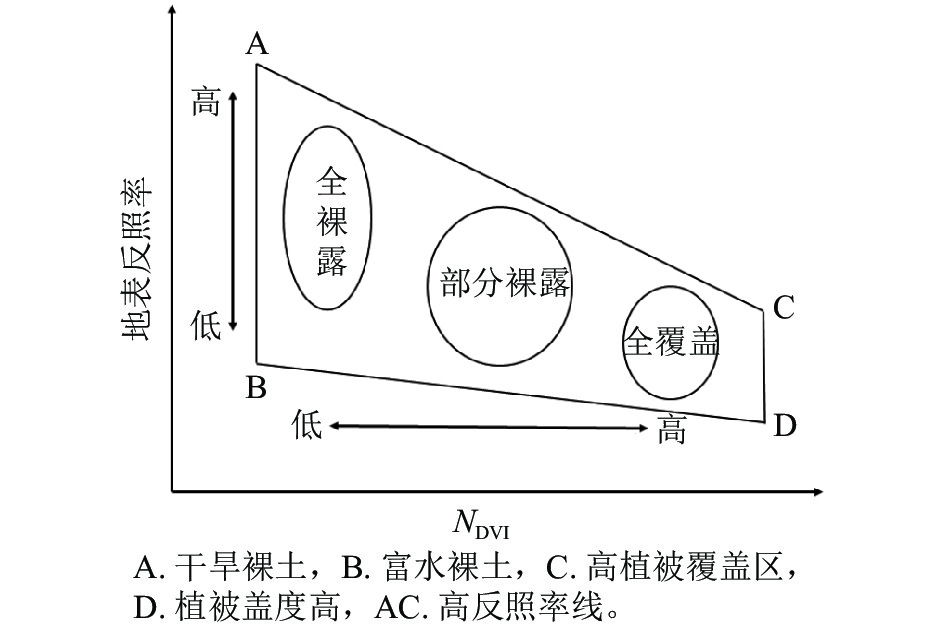
    • 研究表明:Albedo-NDVI特征空间分布图一般呈现梯形或者三角形[25],可将高植被覆盖、部分覆盖和全裸露很好地区分。

      式(3)~(5)中:DDI为荒漠化差值指数;$ A $为地表反照率;NDVI为归一化植被指数;$ k、b $为方程拟合系数;$ \alpha $值由拟合曲线的斜率($ k $)决定。研究表明[26]:基于Jenk最优化法的分界点使各分组方差之和最小,将荒漠化差值指数(DDI)分为5个区间:极重度沙化(DDI≤1.110)、重度沙化(1.110<DDI≤1.453)、中度沙化(1.453<DDI≤1.942)、轻度沙化(1.942<DDI≤2.472)和非沙化土地(DDI>2.472)。

    • 土地沙化动态度($ K $)可定量描述某区域某研究时段内各类沙化土地面积的变化速度,对沙化区域性差异及预测未来趋势有一定优势。单一沙化程度动态度公式如下[27]

      式(6)中:$ K $为研究时段内某一沙化程度动态度;$ {U}_{\mathrm{a}}、{U}_{\mathrm{b}} $分别表示研究初期与末期某种沙化程度的面积;$ T $为研究时段。$ K $<0表明该类沙化土地处于缩减状态,$ K $>0表明该类沙化土地处于扩张状态。当$ T $定义为年时,$ K $值即区域某程度沙化土地的年变化率。

    • 利用回归分析,研究小滦河流域沙化动态随时间变化的趋势[28],计算公式如下:

      式(7)中:S为荒漠化差值指数(DDI)变化趋势的斜率;n为监测年数;DDIi为第$ i $年对应的荒漠化差值指数。根据荒漠化差值指数变化趋势划分为严重退化(S≤−0.20)、轻微退化(−0.20<S≤−0.10)、基本不变(−0.10<S≤0.10)、轻微改善(0.10<S≤0.25)、明显改善(S>0.25)。

    • 转移矩阵可对一定时期单元内不同沙化程度的转移状态做定量分析,反映其变化的方向和特征[29],更好地揭示沙化土地的时空演化过程。数学表达形式为:

      式(8)中:${S}_{hj}$表示初期对应h类沙化土地转变为末期$ j $类沙化土地的面积;$ m $表示沙化土地相应程度的数目。

    • 景观格局指数以斑块作为基本单元用以分析各景观类别的结构组成及空间特征[30],根据景观生态学理论,结合小滦河流域实际情况,选取面积周长维数、蔓延度指数、凝聚度指数、分离度指数、香农多样性指数、香农均匀度指数、聚集度指数等7类景观格局指数,运用Fragstats 4.2软件对小滦河流域3期土地沙化景观格局特征进行分析。

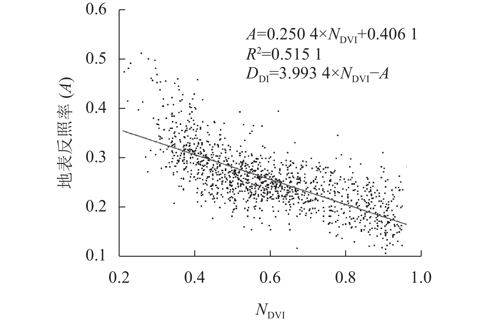
    • 研究表明[25]:高反照率线(AC)与沙化过程在Albedo-NDVI特征空间中的轨迹较为接近,选取垂直于高反照率线的直线将不同沙化土地进行区分,荒漠化差值指数中斜率$ \alpha =-1/k $,即荒漠化差值指数表现为Albedo-NDVI特征空间垂直于高反照率线的各分割直线位置,代表不同沙化土地在特征空间中的地表水热组合及动态变化差异(图1)。基于3期数据构建Albedo-NDVI特征方程,衍生出荒漠化差值指数,可用于土地沙化程度分级[31]。基于ArcGIS和RStudio,随机选取研究区内1 256个样本点进行回归分析(以2000年为例)。从图2可见:Albedo与NDVI具有明显的线性负相关,R2为0.515 1。

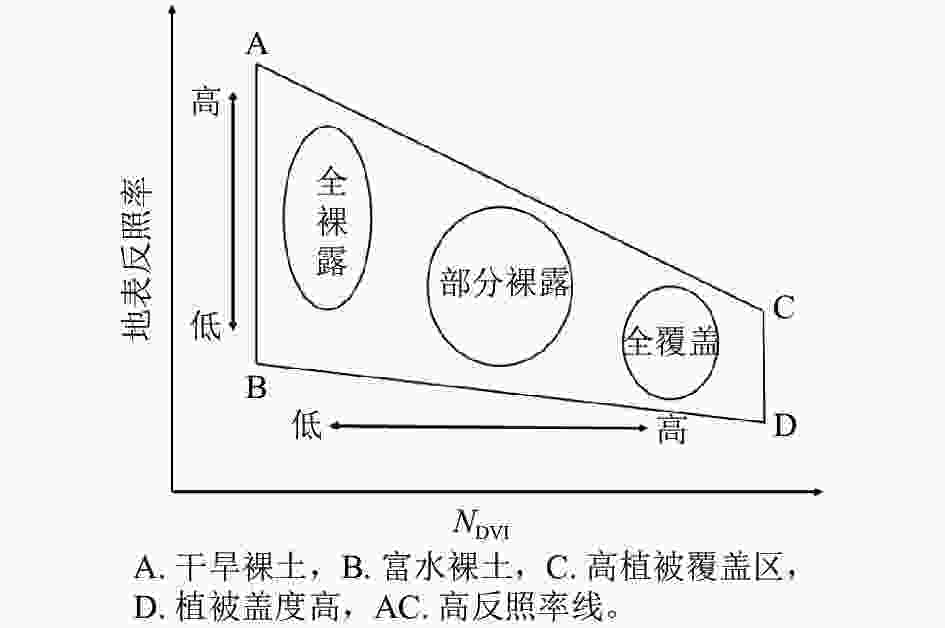
      Figure 1.  Albedo-NDVI feature space

      Figure 2.  Albedo-NDVI feature space scatter plot and linear equation

      基于Google Earth Pro历史影像数据,随机选取300个样本点对3期沙化土地进行精度验证,结合2021年8月野外调查数据进行目视解译,以此判断验证点沙化程度类别,生成2000、2010和2020年沙化土地分类精度评价混淆矩阵(表1)。由表1可见:总体精度为79.33%~84.67%,表明基于Albedo-NDVI特征空间方法在沙化程度区分中结果良好,分类精度满足实验要求。

      年份实际值预测值样本点
      总数
      非沙化轻度
      沙化
      中度
      沙化
      重度
      沙化
      极重度
      沙化
      2000 非沙化 29 3 1 0 0 33
      轻度 2 75 4 2 1 84
      中度 1 6 39 11 2 59
      重度 1 4 7 53 5 70
      极重度 0 1 2 5 46 54
      总体精度/% 80.67
      Kappa系数 0.753
      2010 非沙化 22 5 4 2 0 33
      轻度 2 78 3 1 0 84
      中度 2 3 43 9 2 59
      重度 1 1 4 58 6 70
      极重度 0 0 1 1 52 54
      总体精度/% 84.33
      Kappa系数 0.800
      2020 非沙化 27 4 1 1 0 33
      轻度 2 71 6 5 1 85
      中度 3 4 47 2 3 59
      重度 1 4 2 54 9 70
      极重度 1 2 4 7 39 53
      总体精度/% 79.33
      Kappa系数 0.737

      Table 1.  Confusion matrix of sandy land classification accuracy evaluation in Xiaoluanhe River Basin
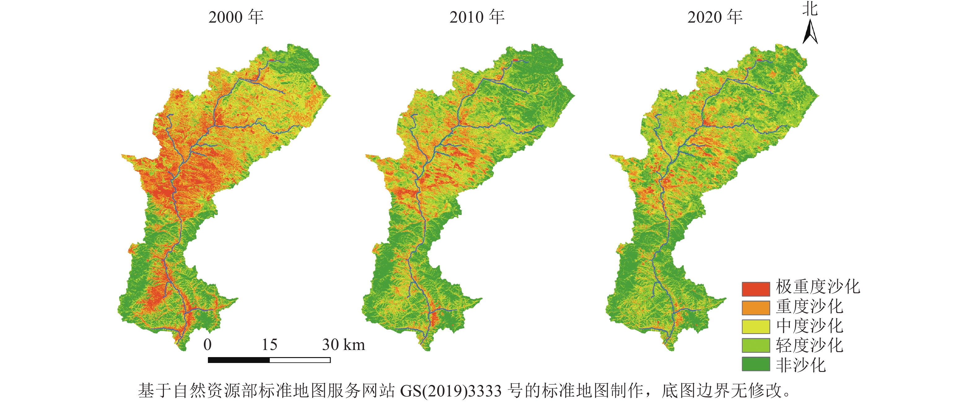
    • 图3可知:小滦河流域极重度、重度沙化土地集中分布在御道口镇、御道口牧场等。中度沙化土地分布范围较广,涉及中、上游大部分地区。而下游以轻度沙化和非沙化为主,包括老窝铺乡、西龙头乡、南山嘴乡;小滦河流域中、下游沙化情况持续好转,而上游地区在2010年后沙化土地有所增加。

      Figure 3.  Spatial and temporal distribution map of land desertification in Xiaoluanhe River Basin based on desertification difference index

      表2可以看出:2000—2010年小滦河流域沙化土地面积变化幅度明显,极重度沙化土地面积减少了165.31 km2,重度沙化土地面积减少了171.21 km2,动态度分别为−6.88%、−4.18%;轻度沙化、非沙化土地面积分别增加了186.47、219.18 km2,其中非沙化土地动态度达6.98%。从空间分布看出,下游地区大范围沙化土地转变为非沙化土地,中游地区由极重度和重度沙化连片分布转变为斑块状零散分布(图3)。2010—2020年,小滦河流域极重度、重度沙化土地面积进一步减小,其中极重度、重度沙化土地变化速率相对较大,动态度分别为−3.40%、−2.44%,不同沙化程度土地动态度均有缩减。极重度、重度沙化土地面积持续缩小,轻度沙化土地面积持续增加,但变化幅度较2000—2010年均有所减少。表明小滦河流域沙化状况整体有所好转,极重度、重度沙化面积和占比有明显减少,上游地区的沙化趋势不容忽视。

      土地沙化程度2000年2010年2020年
      面积/km2占比/%面积/km2占比/%2000—2010动态度/%面积/km2占比/%2010—2020动态度/%
      极重度  240.2814.5174.974.53−6.8849.452.99−3.40
      重度   409.6224.74238.4114.40−4.18180.2810.89−2.44
      中度   413.3524.96344.2220.79−1.67348.7021.060.13
      轻度   278.6416.83465.1128.096.69553.2233.411.89
      非沙化土地313.8618.96533.0432.196.98524.1031.65−0.17
      总计   1 655.75100.001655.75100.001655.75100.00

      Table 2.  Characteristics of land desertification dynamic change in the Xiaoluan River Basin from 2000 to 2020

    • 2000—2020年,小滦河流域土地沙化总体得到改善,不同程度沙化土地的变化趋势和幅度各不相同。如图4A所示:在2000—2010年,极重度转为重度沙化土地面积为95.36 km2,占极重度沙化土地面积的39.69%,重度转为中度沙化土地面积为164.59 km2,占重度沙化土地面积的40.18%,中度转为轻度沙化土地面积为201.08 km2,占中度沙化土地面积的48.65%,轻度转为非沙化土地面积为129.10 km2,占轻度沙化土地面积的46.33%,表明前期小滦河流域沙化土地改善幅度较大,以相邻土地沙化发生转移。如图4B所示:2010—2020年,小滦河流域中度沙化转为轻度沙化面积达137.82 km2,轻度转为非沙化土地面积103.88 km2,重度转中度沙化土地面积为100.80 km2,但存在非沙化转向轻度沙化,轻度转向中度沙化土地的现象,转移面积分别为118.06 、81.14 km2。相较2010年前,小滦河流域改善面积有所缩减,且293.81 km2的非沙化、轻度沙化等土地向沙化程度严重的类型转变,流域部分区域的沙化状况恶化加剧。

      Figure 4.  Matrix of desertification land change of the Xiaoluanhe River Basin

      图5所示:2000—2020年,流域呈明显改善和轻度改善状态的土地面积分别占总面积的17.18%和24.28%,呈严重退化和轻度退化的土地面积之和不足10%。表明20 a间小滦河流域的沙化状况总体有明显改善,主要分布于北部塞罕坝林场及小滦河流域下游,而以轻度退化为主的土地沙化加剧状况分别集中在御道口牧场、御道口镇等区域及周边。

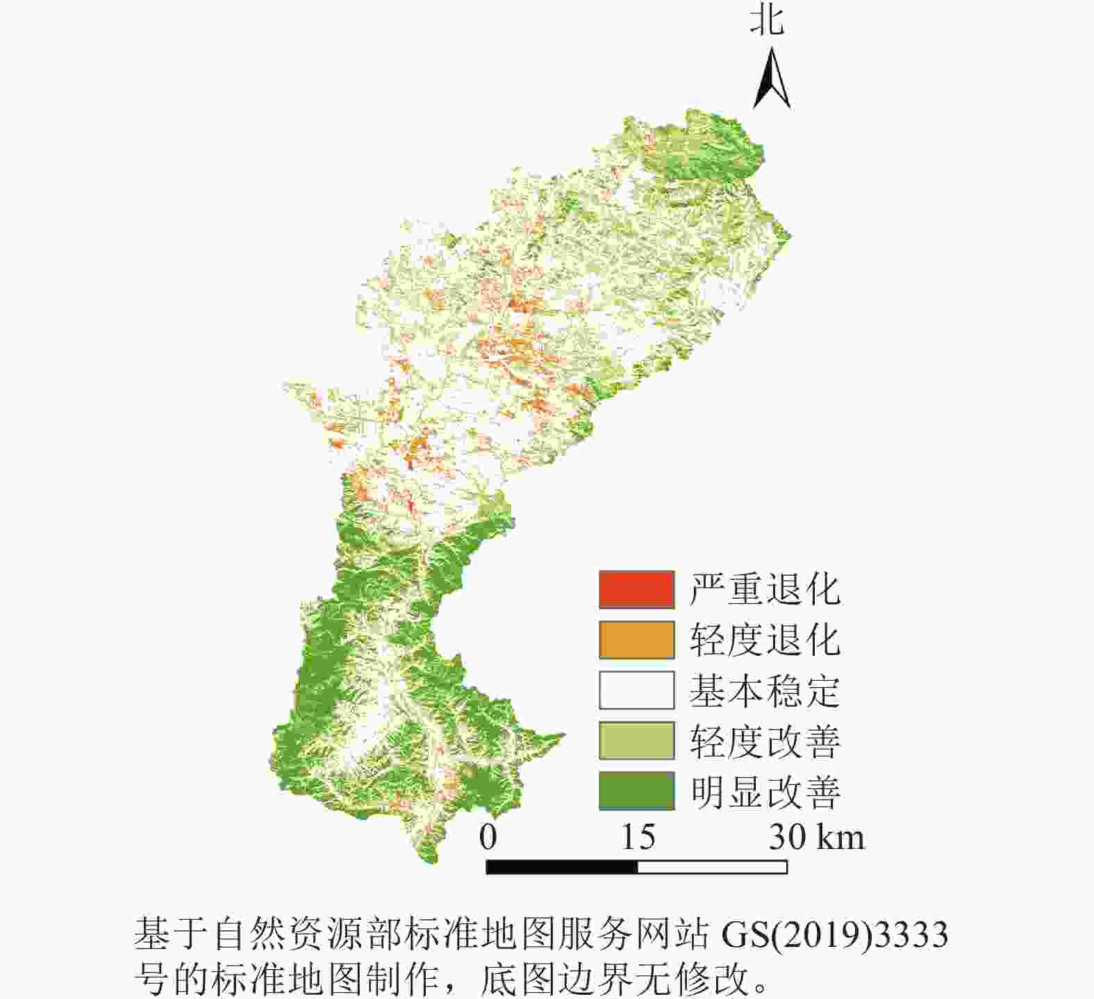
      Figure 5.  Changes in the spatial and temporal pattern of land desertification of the Xiaoluanhe River Basin from 2000 to 2020

    • 表3所示:20 a间小滦河流域凝聚度指数呈先减后增趋势,总体为增加趋势,说明不同沙化景观程度间同类斑块的自然连通度提高。蔓延度指数、聚集度指数均为连年上升,前者增加了8.215,聚集度指数增加了3.589,且2010年前增幅超过后期,说明小滦河流域沙化景观集聚程度逐渐提升,流域景观中小斑块数量减少,在空间分布上趋向于集中,流域景观破碎化程度持续降低。面积周长维数持续减小,流域沙化景观的几何形状复杂程度及分布情况趋于简单。同时,分离度指数呈微弱的减少趋势,景观沙化土地分散程度减小,香农多样性和均匀度指数均有降低,分别降低了0.182、0.113,在2000—2010年下降趋势较为明显,表明小滦河流域沙化景观的多样性和异质性有所减缓,破碎化程度随景观类型复杂程度的减少而变小。

      年份面积周长维数蔓延度指数凝聚度指数分离度指数香农多样性指数香农均匀度指数聚集度指数
      20001.51426.14598.3230.9891.5870.98672.953
      20101.51231.77697.8790.9911.4670.91275.228
      20201.49434.36098.3570.9881.4050.87376.542

      Table 3.  Changes of landscape pattern index of land desertification landscape level in Xiaoluanhe River Basin from 2000 to 2020

    • 人为因素驱动下的土地利用类型对区域土地沙化有着改善或者恶化的作用,从而引起土地沙化并发生改变。由表4可见:2000—2010年,耕地的极重度和重度沙化面积共减少了76.33 km2,占同期沙化土地改善面积的15.86%,林地的极重度、重度和中度沙化面积减幅最大,达225.52 km2,未利用土地的沙化面积减少82.08 km2。10 a内草地面积增加最多,达83.25 km2,草地的沙化土地改善面积占草地总面积的20.06%。在2010—2020年,草地为小滦河流域沙化改善的主要地类。其中,耕地的极重度、重度和中度沙化土地面积持续减少,林地非沙化土地面积减少62.26 km2,总面积未有明显改变,而重度、中度和轻度沙化面积均有所增加。这一时期未利用土地面积变化较小,且各类沙化土地均有好转。后10 a间草地面积变幅较小,但其土地沙化好转面积最为突出,其中极重度、重度和中度沙化土地面积减少63.90 km2,占同期沙化土地改善面积的57.70%。

      土地沙化程度年份土地利用面积/km2
      耕地林地草地水域建设用地未利用土地
      极重度沙化200066.0628.02101.261.200.8942.85
      201014.667.4246.660.711.494.04
      20208.595.5428.700.562.054.01
      重度沙化 200070.36112.06182.510.930.9842.78
      201045.4334.45140.620.691.6815.54
      202027.1938.69100.960.671.6711.09
      中度沙化 200030.01216.76126.890.560.4038.74
      201058.9789.45170.820.841.4422.71
      202043.02113.95164.530.941.3824.89
      轻度沙化 200015.76177.0856.770.200.1428.69
      201057.13219.68149.251.381.3736.30
      202067.80250.24190.021.441.6742.04
      非沙化  200010.57273.2826.690.020.023.28
      201022.54419.3170.030.360.4220.39
      202048.69357.0594.630.781.1621.79

      Table 4.  Areas of land use types under different degrees of desertification from 2000 to 2020

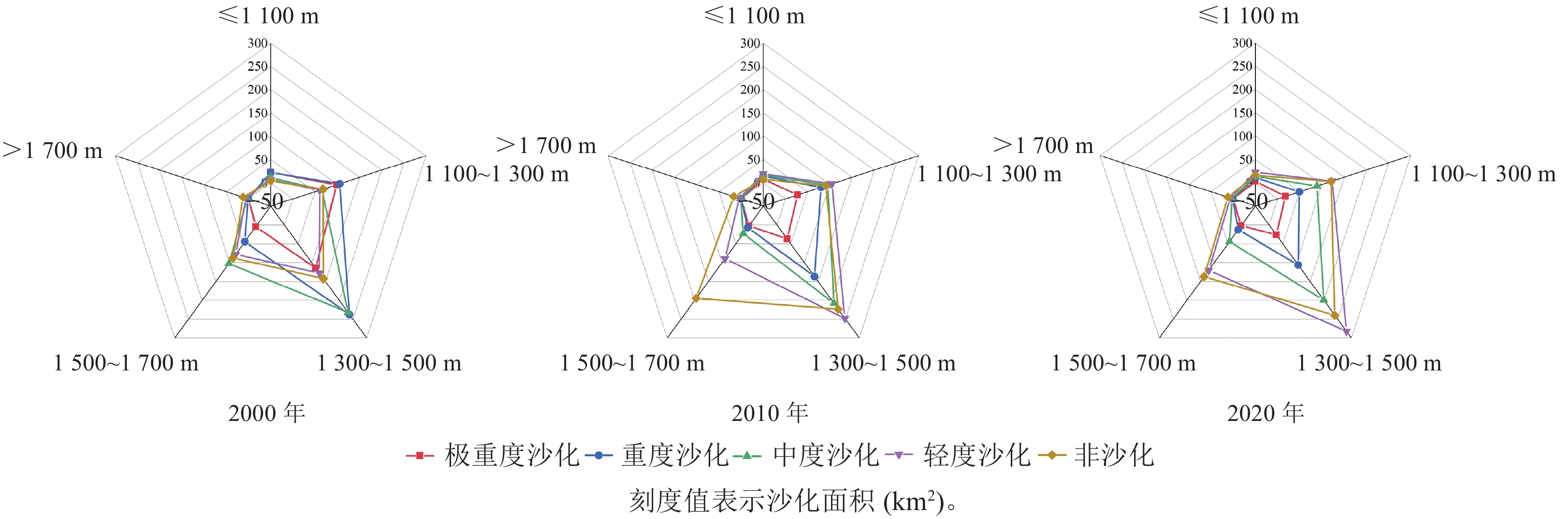
      小滦河流域海拔为910~1 868 m,结合沙化土地分布,以200 m为单位划分5个等级,对不同海拔的沙化土地面积进行分析。如图6所示:20 a间小滦河流域各类沙化土地主要分布于海拔1 300~1 500 m。前期土地沙化在海拔1 300~1 500、1 500~1 700和1 100~1 300 m缩减最为明显,其中,海拔1 100~1 300 m以极重度沙化土地减轻为主,1 300~1 500 m以重度沙化减轻为主,1 500~1 700 m以中度沙化面积减少为主,其余海拔范围的沙化好转面积较小。2010—2020年,不同海拔之间极重度、重度沙化土地面积有轻微减少,在海拔1 300~1 500 m,非沙化、轻度沙化土地面积增幅最大。海拔1 500~1 700 m非沙化土地面积减少了57.64 km2,而轻度沙化土地面积增加了30.55 km2,中度沙化土地面积增加了21.49 km2;且分布在海拔1 100~1 300、1 500~1 700 m的土地沙化逆转趋势有所加重,今后需加强治理。

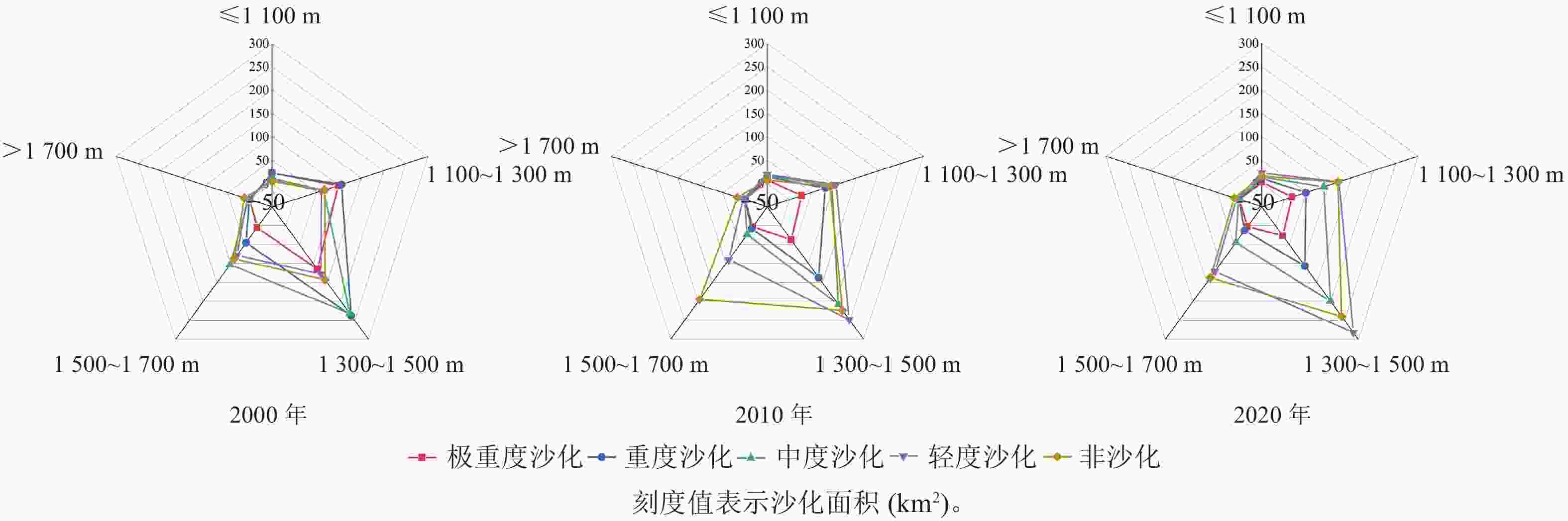
      Figure 6.  Distribution of different desertified land areas in Xiaoluanhe River Basin from 2000 to 2020

      2000—2020年,小滦河流域各土地利用的土地沙化均有不同程度改善。前期(2000—2010年),土地利用类型的变化面积从大到小依次为草地、未利用土地、林地、耕地。沙化土地改善面积从大到小依次为林地、草地、未利用土地、耕地,林地最为突出。不同海拔范围的沙化改善程度有所不同。后期(2000—2010年),流域土地利用间的转变幅度较小,主要为耕地、林地转为未利用土地。不同地类的沙化改善速率有所降低,从大到小依次为草地、耕地、未利用土地、林地,以草地、林地作为土地沙化逆向转变的主要地类,沙化逆转趋势加重。

    • 本研究表明:小滦河流域土地沙化状况总体向改善的方向发展,主要以轻度、非沙化土地为主,部分土地存在退化趋势,该结论与贾双竹[20]的研究结果相符。从海拔来看,周智勇[32]指出:中高海拔山地、高原的植被覆盖度高,沙化程度改善明显,以轻度和非沙化土地为主。沙化严重区集中在中低海拔区,对应区域植被覆盖较低,是今后需重点关注及治理的区域。此外,依据围场县多年植被景观格局变化特征,对流域沙化景观格局指数进行分析发现:随着流域土地沙化状况的明显改善,景观中小斑块数量减少,连通性有所提高,景观破碎化程度有所减缓。

      联系围场县实际情况可知:自20世纪90年代开始实施农业生态工程,退化牧草地、未利用土地被用于林业建设,使林地成为该区域的主要用地类型。从1998年开始,“三北”防护林工程、京津风沙源治理、坝上生态农业建设项目等相继启动,使围场县作为重点治理区域的沙化情况有所好转[33]。适应当地立地条件的林地,对沙化土地的改善具有促进作用,森林根系发达、自身储存水份等特点使该区域土壤中水分较为充足,林冠、枝干可有效减缓风速,通过截留降水进行雨水再分配,凋落物层进一步减轻对土壤的冲刷和侵蚀。研究区通过人工、固沙造林和稀疏林地补植等措施,使沙化有明显改善,表明森林在土地沙化、水土流失等方面作用突出。草地作为小滦河流域沙化改善的主要用地类型,应建设草地保护与修复项目示范区,同时在退化草地区域人工补种优质牧草[34]。这主要因为草地多为连片分布,根系在土壤密集交错,可使沙化程度降低。

      后期(2010—2020年),小滦河流域土地沙化恶化趋势加剧,御道口镇东北部的草地沙化程度存在加重趋势,且中上游存在着林地被转为耕地、牧场南部的林地转变为草地等现象,均导致流域非沙化、轻度沙化等地块恶化。再者,近年来,由于沙化土地改善与当地经济发展并存,尤其是旅游业的发展使流域受人为因素干扰较大,分布于中低海拔区的建设用地、水域面积有轻微增加,进而对流域沙化动态变化有所影响。同时,草场超载放牧、土地退化、土层浅薄导致水土流失,流域局部地区沙化趋势有所加重。今后需结合小滦河流域实际,加强以草地为重点的沙化改善措施,坚持实施退耕还林还草,以中低海拔区作为今后林草建设的重点区域,优化耕地空间格局及治理,将区域生态旅游发展与居民受益紧密联系,同时对农村环境进行综合改善与整治,实现小滦河流域的可持续发展。

    • 2000—2020年,小滦河流域土地沙化总体呈好转趋势。其中,极重度、重度沙化土地面积分别减少约80%和56%,集中分布于御道口镇及牧场周边,轻度沙化和非沙化分布于下游地区,后期沙化土地恶化趋势加重。流域沙化斑块在空间分布上趋向于集中,景观破碎化程度持续降低。不同地类的土地沙化均有改善,林地为前期土地沙化改善的主要地类,后期以草地、耕地为主,耕地的沙化状况持续好转,林地出现逆向沙化现象。低海拔区以极重度沙化土地减轻为主,中海拔区以重度沙化减轻为主,高海拔区以中度沙化减少为主。

Reference (34)

Catalog

    /

    DownLoad:  Full-Size Img  PowerPoint
    Return
    Return