Volume 41 Issue 2
Apr.  2024
Turn off MathJax
Article Contents

ZOU Weimin, DING Jun, HUANG Zihao, HUANG Lei, SONG Meixuan, LI Xuejian, DU Huaqiang. Remote sensing monitoring of subtropical forest disturbance and restoration in Songyang County, Zhejiang Province[J]. Journal of Zhejiang A&F University, 2024, 41(2): 353-361. doi: 10.11833/j.issn.2095-0756.20230324
Citation: ZOU Weimin, DING Jun, HUANG Zihao, HUANG Lei, SONG Meixuan, LI Xuejian, DU Huaqiang. Remote sensing monitoring of subtropical forest disturbance and restoration in Songyang County, Zhejiang Province[J]. Journal of Zhejiang A&F University, 2024, 41(2): 353-361. doi: 10.11833/j.issn.2095-0756.20230324

Remote sensing monitoring of subtropical forest disturbance and restoration in Songyang County, Zhejiang Province

doi: 10.11833/j.issn.2095-0756.20230324
  • Received Date: 2023-05-21
  • Accepted Date: 2023-08-15
  • Rev Recd Date: 2023-08-08
  • Available Online: 2024-03-21
  • Publish Date: 2024-04-01
  •   Objective  Songyang County in Zhejiang Province is rich in forest resources and has great potential for carbon sinks, and is a tertiary linkage area of Baishanzu National Park. This study aims to monitor forest disturbance and restoration in Songyang County, so as to provide an important reference for forest management in this region and ecological protection for Baishanzu National Park.   Method  Using the LandTrendr algorithm of the Google Earth Engine (GEE) cloud platform, as well as Landsat satellite remote sensing time series data from 1987 to 2020, the forest disturbance and restoration status in Songyang County, Zhejiang Province from 1987 to 2020 were detected, and the spatial and temporal characteristics of forest disturbance and restoration were analyzed.   Result  (1) The overall accuracy of the LandTrendr algorithm in detecting forest disturbance and restoration reached 82%, and the production accuracyand user accuracy of forest disturbance and restoration were both higher than 80%, indicating that the monitoring of forest disturbance and restoration in Songyang County was effective. (2) The total area of forest disturbance and restoration in Songyang County reached 148.14 and 236.86 km2, accounting for 12.74% and 20.37% of the forest land area, indicating a net increase in forest area in Songyang County from 1987 to 2020. (3) Forest changes in Dadongba Township, Banqiao She Township, Xinxing Township and Yuyan Township in Songyang County were relatively frequent, and the area of forest disturbance and restoration was higher than that in other townships. In particular, the forest area of Dadongba Township changed the most, with an increase of 20.04 km2.  Conclusion  The LandTrendr algorithm based on the GEE cloud platform has achieved precise monitoring of forest disturbance in this county. The overall forest area in Songyang County has shown an increasing trend in the past 30 years. [Ch, 3 fig. 3 tab. 46 ref.]
  • [1] XU Yue, WU Xiaomeng, CHEN Shiyan, CHENG Honghao, ZHANG Lin, ZHOU Xiazhi, ZOU Yunding, BI Shoudong.  Temporal and spatial relationship between spiders and Ricanidae in tea gardens . Journal of Zhejiang A&F University, 2022, 39(5): 1067-1079. doi: 10.11833/j.issn.2095-0756.20210734
    [2] YANG Shaoqin, WANG Xiang, XU Cheng, SHANG Tianqi.  Estimating bamboo forest aboveground biomass based on MODIS time series data . Journal of Zhejiang A&F University, 2022, 39(4): 734-741. doi: 10.11833/j.issn.2095-0756.20210431
    [3] XU Huozhong, WU Dongtao, LI Guisong, WU Lintu, YE Chunfu, GUO Bin, MA Jiawei, YE Zhengqian, LIU Dan.  Input and output balance of cadmium (Cd) in cultivated land with moderate pollution in Songyang County . Journal of Zhejiang A&F University, 2021, 38(6): 1231-1237. doi: 10.11833/j.issn.2095-0756.20200728
    [4] LI Wanyuan, TIAN Jia, MA Qin, JIN Xuejuan, YANG Zekang, YANG Penghui.  Dynamic monitoring of loess terraces based on Google Earth Engine and machine learning . Journal of Zhejiang A&F University, 2021, 38(4): 730-736. doi: 10.11833/j.issn.2095-0756.20200673
    [5] WANG Lei, CUI Ming, ZHOU Mengling, ZHAO Xiaodong, YAN Weipeng, WU Jianhong, LIU Yuguo.  Plant community characteristics of natural secondary forest with different restoration years in karst area of Xichuan County, Henan Province . Journal of Zhejiang A&F University, 2020, 37(4): 720-728. doi: 10.11833/j.issn.2095-0756.20190498
    [6] YE Sentu, JIN Chao, WU Chuping, YANG Tangliang, JIANG Bo, YUAN Weigao, HUANG Yujie, JIAO Jiejie, SUN Jiejie.  Classification, ordination and correlation analysis of dominant species of ecological non-commercial forests in Songyang, Zhejiang . Journal of Zhejiang A&F University, 2020, 37(4): 693-701. doi: 10.11833/j.issn.2095-0756.20190514
    [7] HUANG Yaohui, ZHANG Chao, ZHOU Lihua, ZHAO Hongbo.  Development and primer screening of SSR markers based on transcriptome sequences in Sinocalycanthus chinensis . Journal of Zhejiang A&F University, 2017, 34(4): 589-596. doi: 10.11833/j.issn.2095-0756.2017.04.004
    [8] WANG Yueting, ZHANG Xiaoli, YANG Huiqiao, WANG Shuhan, BAI Jinting.  Forest volume estimation based on spectral and textural information from the Landsat 8 satellite . Journal of Zhejiang A&F University, 2015, 32(3): 384-391. doi: 10.11833/j.issn.2095-0756.2015.03.008
    [9] WANG Guoli, AN Huaming, QIN Qiaoping, LI Mengjiao, LIU Zhenzhen, CHEN Jiaying, ZHOU Qian, ZHANG Lanlan.  Cloning and sequence analysis of fruit ripening-specific gene CsPMEI/InvI from citrus . Journal of Zhejiang A&F University, 2013, 30(3): 336-342. doi: 10.11833/j.issn.2095-0756.2013.03.005
    [10] RUAN Jiajia, YUAN Jinqiang, YANG Xianyu.  Cloning and sequence analysis of claudin-4 cDNA from Bufo japonicus formosus . Journal of Zhejiang A&F University, 2013, 30(4): 561-566. doi: 10.11833/j.issn.2095-0756.2013.04.016
    [11] ZHANG Chao, YU Shu-quan, LI Tu-sheng.  Image analysis of vegetation coverage and changes (1994 - 2007) in Qingyuan County using multi-temporal Landsat remote sensing . Journal of Zhejiang A&F University, 2011, 28(1): 72-79. doi: 10.11833/j.issn.2095-0756.2011.01.012
    [12] WANG Zheng-jia, HUANG You-jun, XIA Guo-hua, ZHENG Bing-song, JIN Song-heng, HUANG Jian-qin.  Cloning and analysis of the APETALA1(AP1) homolog gene from Carya cathayensis . Journal of Zhejiang A&F University, 2008, 25(4): 427-430.
    [13] HONG Zhen.  Spermatophyte flora of Ruoliaoxian Nature Reserve in Zhejiang . Journal of Zhejiang A&F University, 2006, 23(2): 174-178.
    [14] QIAN Jun, JIN Yong-ming, SHEN Zhe-hong, YU You-ming, LOU Yong-sheng.  Effect of intensity and work time of electric field on moisture gradient of Pinus massoniana wood . Journal of Zhejiang A&F University, 2005, 22(2): 193-197.
    [15] ZHENG Jian-min, QIAN Wen-rong, HE Li-ping.  Selection and development of forest tourism in Kaihua . Journal of Zhejiang A&F University, 2004, 21(3): 333-338.
    [16] LI Zheng-cai, FU Mao-yi, XIE Jin-zhong, ZHOU Ben-zhi, XIAO Ti-quan, WU Ming.  Carbon sequestration of 5 ecological reestablishment vegetation types in Muchuan County of Sichuan . Journal of Zhejiang A&F University, 2004, 21(4): 382-387.
    [17] HONG Zhen, LOU Jian-qiang.  Survey and utilization of wild woody ornamental plant resources in Songyang County . Journal of Zhejiang A&F University, 2004, 21(4): 428-432.
    [18] WU Zhang-wen.  Study on duration of comfortable temperature in forest tourist areas in sub-tropical zone . Journal of Zhejiang A&F University, 2003, 20(4): 380-384.
    [19] LIN Yuan-tai.  Restoration ecology on the Castanopsis fargesii forest in Wuyishan, Fujian Ⅰ. The effects of different scale of artificial disturbance on the flora of tree layer of Castanopsis fargesii . Journal of Zhejiang A&F University, 2001, 18(3): 252-256.
    [20] Li Genyou, Lou Luhuan, Lü Zhengshui, Gu Zhenqiang, Wu Lijun.  Edible Wild Herbs Resources and Utilization of Taishun County . Journal of Zhejiang A&F University, 1994, 11(4): 429-448.
  • [1]
    FANG Jingyun, CHEN Anping, PENG Changhui, et al. Changes in forest biomass carbon storage in China between 1949 and 1998 [J]. Science, 2001, 292(5525): 2320 − 2322.
    [2]
    GATTI L V, BASSO L S, MILLER J B, et al. Amazonia as a carbon source linked to deforestation and climate change [J]. Nature, 2021, 595(7867): 388 − 893.
    [3]
    PAN Yude, BIRDSEY R A, FANG Jingyun, et al. A large and persistent carbon sink in the world’s forests [J]. Science, 2011, 333(6045): 988 − 993.
    [4]
    DASKALOVA G N, MYERS-SMITH I H, BJORKMAN A D, et al. Landscape-scale forest loss as a catalyst of population and biodiversity change [J]. Science, 2020, 368(6497): 1341 − 1347.
    [5]
    DIXON R K, BROWN S, HOUGHTON R A, et al. Carbon pools and flux of global forest ecosystems [J]. Science, 1994, 263(5144): 185 − 190.
    [6]
    FORZIERI G, DAKOS V, MCDOWELL N G, et al. Emerging signals of declining forest resilience under climate change [J]. Nature, 2022, 608(7923): 534 − 539.
    [7]
    SEIBOLD S, RAMMER W, HOTHORN T, et al. The contribution of insects to global forest deadwood decomposition [J]. Nature, 2021, 597(7874): 77 − 81.
    [8]
    COHEN W B, YANG Zhiqiang, STEHMAN S V, et al. Forest disturbance across the conterminous United States from 1985–2012: the emerging dominance of forest decline [J]. Forest Ecology and Management, 2016, 360: 242 − 252.
    [9]
    EDWARDS D P, TOBIAS J A, SHEIL D, et al. Maintaining ecosystem function and services in logged tropical forests [J]. Trends in Ecology &Evolution, 2014, 29(9): 511 − 520.
    [10]
    PFLUGMACHER D, COHEN W B, KENNEDY R E. Using landsat-derived disturbance history (1972–2010) to predict current forest structure [J]. Remote Sensing of Environment, 2012, 122: 146 − 165.
    [11]
    SHEN Wenjuan, LI Mingshi. Mapping disturbance and recovery of plantation forests in southern China using yearly Landsat time series observations [J]. Acta Ecologica Sinica, 2017, 37(5): 1438 − 1449.
    [12]
    TURNER D P, RITTS W D, KENNEDY R E, et al. Effects of harvest, fire, and pest/pathogen disturbances on the West Cascades ecoregion carbon balance[J/OL]. Carbon Balance and Management, 2015, 10[2023-04-21]. doi: 10.1186/s13021-015-0022-9.
    [13]
    MA Xiaozhe, WANG Zheng. Progress in the study on the impact of land-usr change on reginal carbon doruces and sinks [J]. Acta Ecologica Sinica, 2015, 35(17): 5898 − 5907.
    [14]
    QU Futian, LU Na, FENG Suyi. Effect of landuse change emissions [J]. China Population,Resources and Environment, 2011, 21(10): 76 − 83.
    [15]
    ZHOU Jianfen, GUAN Dongsheng. Change in the use of forest land and its impact on the carbon cycling [J]. Ecology and Environment, 2004, 13(4): 674 − 676.
    [16]
    SHEN Wenjuan, LI Mingshi, HUANG Chengquan. Review of remote sensing algorithms for monitoring forest disturbance from time series and multi-source data fusion [J]. Journal of Remote Sensing, 2018, 22(6): 1005 − 1022.
    [17]
    HOUGHTON R A. Aboveground forest biomass and the global carbon balance [J]. Global Change Biology, 2005, 11(6): 945 − 958.
    [18]
    LÜ Yingying, ZHUANG Yilin, REN Xinyu, et al. Automated mapping of urban forests’ disturbance and recovery in Nanjing, China [J]. Chinese Journal of Applied Ecology, 2016, 27(2): 429 − 435.
    [19]
    LIU Shanshan, HUANG Xinyi, ZHAO Shuai, et al. Analysis of forest disturbance and recovery dynamic characteristics based on LandTrendr Time segmental algorithm [J]. Journal of Subtropical Resources and Environment, 2020, 15(4): 15 − 22.
    [20]
    COPPIN P, JONCKHEERE I, NACKAERTS K, et al. Digital change detection methods in ecosystem monitoring: a review [J]. International Journal of Remote Sensing, 2004, 25(9): 1565 − 1596.
    [21]
    BANSKOTA A, KAYASTHA N, FALKOWSKI M J, et al. Forest monitoring using Landsat time series data: a review [J]. Canadian Journal of Remote Sensing, 2014, 40(5): 362 − 384.
    [22]
    ZHU Shanyou, ZHANG Ying, ZHANG Hailong, et al. Progress of researches of on monitoring large-area forest disturbance by Landsat satllite images [J]. Remote Sensing for Land &Resources, 2014, 26(2): 5 − 10.
    [23]
    YANG Chen, SHEN Runping, YU Dawei, et al. Forest disturbance monitoring based on the time-series trajectory of remote sensing index [J]. Journal of Remote Sensing, 2013, 17(5): 1246 − 1263.
    [24]
    HUANG Chengquan, GOWARD S N, MASEK J G, et al. An automated approach for reconstructing recent forest disturbance history using dense Landsat time series stacks [J]. Remote Sensing of Environment, 2010, 114(1): 183 − 198.
    [25]
    KENNEDY R E, YANG Zhiqiang, COHEN W B. Detecting trends in forest disturbance and recovery using yearly Landsat time series: 1. LandTrendr-Temporal segmentation algorithms [J]. Remote Sensing of Environment, 2010, 114(12): 2897 − 2910.
    [26]
    OBATA S, BETTINGER P, CIESZEWSKI C J, et al. Mapping forest disturbances between 1987–2016 using all available time series landsat TM/ETM+ imagery: developing a reliable methodology for Georgia, United States [J/OL]. Forests, 2020, 11(3): 335[2023-04-20]. doi:10.3390/f11030335.
    [27]
    SCHLEEWEIS K G, MOISEN G G, SCHROEDER T A, et al. US national maps attributing forest change: 1986–2010 [J/OL]. Forests, 2020, 11(6): 653[2023-08-20]. doi: 10.3390/f11060653.
    [28]
    VERBESSELT J, HYNDMAN R, NEWNHAM G, et al. Detecting trend and seasonal changes in satellite image time series [J]. Remote Sensing of Environment, 2010, 114(1): 106 − 115.
    [29]
    BRIGHT B C, HUDAK A T, KENNEDY R E, et al. Landsat time series and lidar as predictors of live and dead basal area across five bark beetle-affected forests [J]. IEEE Journal of Selected Topics in Applied Earth Observations and Remote Sensing, 2014, 7(8): 3440 − 3452.
    [30]
    YANG Yongjun, ERSKINE P D, LECHNER A M, et al. Detecting the dynamics of vegetation disturbance and recovery in surface mining area via Landsat imagery and LandTrendr algorithm [J]. Journal of Cleaner Production, 2018, 178: 353 − 362.
    [31]
    YAN Jining, WANG Lizhe, SONG Weijing, et al. A time-series classification approach based on change detection for rapid land cover mapping [J]. ISPRS Journal of Photogrammetry and Remote Sensing, 2019, 158: 249 − 262.
    [32]
    WANG Zhenyu, LECHNER A M, YANG Yongjun, et al. Mapping the cumulative impacts of long-term mining disturbance and progressive rehabilitation on ecosystem services[J/OL]. Science of the Total Environment, 2020, 717: 137214[2023-04-21]. doi: 10.1016/j.scitotenv.2020.137214.
    [33]
    SAXENA R, WATSON L T, WYNNE R H, et al. Towards a polyalgorithm for land use change detection [J]. ISPRS Journal of Photogrammetry and Remote Sensing, 2018, 144(1): 217 − 234.
    [34]
    COHEN W B, HEALEY S P, YANG Zhiqiang, et al. How similar are forest disturbance maps derived from different Landsat time series algorithms? [J/OL]. Forests, 2017, 8(4): 98[2023-04-20]. doi:10.3390/f8040098.
    [35]
    LIU Shuangna, ZHOU Tao, WEI Linyan, et al. The spatial distribution of forest carbon sinks and sources in China [J]. Chinese Science Bulletin, 2012, 57(11): 943 − 950.
    [36]
    CHEN Wenjun, CHEN J M, PRICE D T, et al. Effects of stand age on net primary productivity of boreal black spruce forests in Ontario, Canada [J]. Canadian Journal of Forest Research, 2002, 32(5): 833 − 842.
    [37]
    ZHANG Xiao, LIU Liangyun, CHEN Xidong, et al. GLC_FCS30: Global land-cover product with fine classification system at 30 m using time-series Landsat imagery [J]. Earth System Science Data, 2021, 13(6): 2753 − 2776.
    [38]
    COHEN W B, YANG Zhiqiang, HEALE S P, et al. A LandTrendr multispectral ensemble for forest disturbance detection [J]. Remote Sensing of Environment, 2018, 205: 131 − 140.
    [39]
    GROGAN K, PFLUGMACHER D, HOSTERT P, et al. Cross-border forest disturbance and the role of natural rubber in mainland Southeast Asia using annual Landsat time series [J]. Remote Sensing of Environment, 2015, 169: 438 − 453.
    [40]
    COHEN W B, YANG Zhiqiang, KENNEDY R. Detecting trends in forest disturbance and recovery using yearly Landsat time series: 2. TimeSync: tools for calibration and validation [J]. Remote Sensing of Environment, 2010, 114(12): 2911 − 2924.
    [41]
    KENNEDY R E, YANG Zhiqiang, GORELICK N, et al. Implementation of the LandTrendr Algorithm on Google Earth Engine [J/OL]. Remote Sensing, 2018, 10(5): 691[2023-04-20]. doi:10.3390/rs10050691.
    [42]
    XU Hanzeyu, WEI Yuchun, LIU Chong, et al. A scheme for the long-term monitoring of impervious-relevant land disturbances using high frequency Landsat archives and the Google Earth Engine[J/OL]. Remote Sensing, 2019, 11(16): 1891[2023-04-20]. doi: 10.3390/rs11161891.
    [43]
    CAO Kunfang, CHANG Jie. The ecological effects of an unusual climatic disaster: the destruction to forest ecosystems by the extremely heavy glaze and snow storms occurred in early 2008 in southern China [J]. Chinese Journal of Plant Ecology, 2010, 34(2): 123 − 124.
    [44]
    YIN Qidong, LIU Caixia, TIAN Ye. Detecting dynamics of vegetaion disturbance in forest natural reserve using Landsat imagery and Landtrendr algorithm: the case of Chaisong and Taibaishan Natural Reserves in Shaanxi, China [J]. Acta Ecologica Sinica, 2020, 40(20): 7343 − 7352.
    [45]
    SHEN Jianing, CHEN Guangsheng, HUA Jianwen, et al. Contrasting forest loss and gain patterns in subtropical China detected using an integrated LandTrendr and Machine-Learning Method [J/OL]. Remote Sensing, 2022, 14(13): 3238[2023-04-20]. doi: 10.3390/rs14133238.
    [46]
    HUA Jianwen, CHEN Guangsheng, YU Lin, et al. Improved mapping of long-term forest disturbance and recovery dynamics in the subtropical China using all available Landsat Time-Series Imagery on Google Earth Engine Platform [J]. IEEE Journal of Selected Topics in Applied Earth Observations and Remote Sensing, 2021, 14: 2754 − 2768.
  • 加载中
通讯作者: 陈斌, bchen63@163.com
  • 1. 

    沈阳化工大学材料科学与工程学院 沈阳 110142

  1. 本站搜索
  2. 百度学术搜索
  3. 万方数据库搜索
  4. CNKI搜索

Figures(3)  / Tables(3)

Article views(281) PDF downloads(38) Cited by()

Related
Proportional views

Remote sensing monitoring of subtropical forest disturbance and restoration in Songyang County, Zhejiang Province

doi: 10.11833/j.issn.2095-0756.20230324

Abstract:   Objective  Songyang County in Zhejiang Province is rich in forest resources and has great potential for carbon sinks, and is a tertiary linkage area of Baishanzu National Park. This study aims to monitor forest disturbance and restoration in Songyang County, so as to provide an important reference for forest management in this region and ecological protection for Baishanzu National Park.   Method  Using the LandTrendr algorithm of the Google Earth Engine (GEE) cloud platform, as well as Landsat satellite remote sensing time series data from 1987 to 2020, the forest disturbance and restoration status in Songyang County, Zhejiang Province from 1987 to 2020 were detected, and the spatial and temporal characteristics of forest disturbance and restoration were analyzed.   Result  (1) The overall accuracy of the LandTrendr algorithm in detecting forest disturbance and restoration reached 82%, and the production accuracyand user accuracy of forest disturbance and restoration were both higher than 80%, indicating that the monitoring of forest disturbance and restoration in Songyang County was effective. (2) The total area of forest disturbance and restoration in Songyang County reached 148.14 and 236.86 km2, accounting for 12.74% and 20.37% of the forest land area, indicating a net increase in forest area in Songyang County from 1987 to 2020. (3) Forest changes in Dadongba Township, Banqiao She Township, Xinxing Township and Yuyan Township in Songyang County were relatively frequent, and the area of forest disturbance and restoration was higher than that in other townships. In particular, the forest area of Dadongba Township changed the most, with an increase of 20.04 km2.  Conclusion  The LandTrendr algorithm based on the GEE cloud platform has achieved precise monitoring of forest disturbance in this county. The overall forest area in Songyang County has shown an increasing trend in the past 30 years. [Ch, 3 fig. 3 tab. 46 ref.]

ZOU Weimin, DING Jun, HUANG Zihao, HUANG Lei, SONG Meixuan, LI Xuejian, DU Huaqiang. Remote sensing monitoring of subtropical forest disturbance and restoration in Songyang County, Zhejiang Province[J]. Journal of Zhejiang A&F University, 2024, 41(2): 353-361. doi: 10.11833/j.issn.2095-0756.20230324
Citation: ZOU Weimin, DING Jun, HUANG Zihao, HUANG Lei, SONG Meixuan, LI Xuejian, DU Huaqiang. Remote sensing monitoring of subtropical forest disturbance and restoration in Songyang County, Zhejiang Province[J]. Journal of Zhejiang A&F University, 2024, 41(2): 353-361. doi: 10.11833/j.issn.2095-0756.20230324
  • 森林作为陆地生态系统的主体,是全球气候系统的重要组成部分,森林生态系统的碳循环是全球陆地碳循环与气候变化响应研究的重要内容[14]。森林容易受海陆位置以及气候条件(如夏季高温、台风等)的影响,同时,人类活动对森林的干扰也较为频繁,因此森林所受干扰特性较为复杂。森林干扰与恢复引起的森林变化,直接影响地表水文、气候以及生物地球化学循环过程[57]。干扰与恢复是森林生态系统动态变化的主要驱动力,干扰与恢复的历史会影响林分的生长状态,不同干扰与恢复的类别、强度与大小将会改变林分物种组成与林分结构[810]。典型的自然干扰(雨雪灾害等)与人为干扰(采伐、土地利用变化等)以及干扰后更新,都将影响森林碳汇[1112]。目前,缺乏长时期的森林时空动态监测资料,森林干扰与恢复对于森林碳循环的贡献仍不确定[1315]。因此,监测森林干扰与恢复,揭示和掌握森林干扰与恢复的时空变化特征,对于理解景观、区域甚至全球尺度的森林碳循环和气候变化至关重要[1617]

    遥感技术具有大面积同步观测、覆盖范围广、时效性好等特点,可作为森林干扰与恢复监测的重要技术手段[11, 1819]。传统的森林变化监测往往采用时间跨度大的2期或者多期同一地区影像进行分类对比分析[20]。过去20 a内通常采用MODIS和AVHRR等高时间分辨率和低空间分辨率的影像进行长时间序列分析[21]。此类方法对于面积较小区域的(如县域)森林变化监测能力较差。近年来,30 m的Landsat卫星影像构成的时间序列堆栈(LTSS)数据为精确的森林干扰监测提供了重要的数据支撑[2223]

    森林干扰与恢复的监测方法主要有分类比较法、影像差异法、分类及统计分析法、时间序列分析法、数据融合法等[16, 23]。与其他方法相比,时间序列分析方法能够确定森林干扰与恢复发生的年份、持续时间、干扰强度等信息,能够有效地监测森林的长期变化状况[19, 23]。时间序列分析法主要包含基于光谱轨迹的Landsat干扰和恢复趋势监测(LandTrendr)、持续变化监测与分类(CCDC)、植被变化跟踪(VCT)以及季节与趋势断点监测(BFAST)等算法[2429]。其中,VCT能够较好监测森林变化,但不能有效监测间伐与森林退化等干扰;BFAST算法对于影像要求较高,在云覆盖高的区域监测效果欠佳;LandTrendr算法却能识别急剧(皆伐等)和缓慢变化(干扰后更新等)的事件,能够有效且精确地监测到森林干扰与恢复。因此,采用LandTrendr算法监测森林干扰与恢复逐渐成为森林干扰与恢复监测的主要方法[3033]

    自20世纪80年代起,中国亚热带森林覆盖率显著增加,较小的林龄结构与充沛的雨热条件使得该区域森林有可能成为全球较大的碳汇区[3435]。持续的森林干扰与恢复带来的林龄效应将会严重影响该区域的碳收支情况[16, 36]。浙江省松阳县森林资源丰富,碳汇潜力巨大,是百山祖国家公园三级联动区,因此,监测松阳县森林变化可为准确评估该区域森林发展态势,为森林经营规划提供理论依据与技术支撑,也对提高亚热带森林的抗干扰能力,增强亚热带森林的自然恢复能力和保护百山祖国家公园生态环境具有重要的参考意义。本研究以松阳县为例,基于长时间序列的LandsatTM/OLI影像数据,采用LandTrendr算法监测松阳县森林干扰与恢复,分析其时空动态变化,从而为松阳县亚热带森林管理提供参考。

    • 松阳县位于浙江省丽水市,地理坐标为28°14′~28°36′N,119°10′~119°42′E。地处浙江省西南部,东连丽水市莲都区,南接龙泉市、云和县,西北靠遂昌县,东北与金华市武义县接壤。全境以中、低山丘陵地带为主,属亚热带季风气候,温暖湿润,四季分明。全县辖3个街道,5个镇,11个乡,总面积为1406.00 km2。截至2022年,松阳县森林面积达1 119.23 km2,森林覆盖率为79.83%。其中公益林面积为637.88 km2,占全县林地总面积的54.9%,松林面积占全县森林面积的59.39%。

    • 本研究基于谷歌地球引擎(GEE)云平台,选取1987—2020年所有可获得的LandsatTM/OLI地表反射率影像作为LandTrendr算法的数据基础。所选择的影像都属于Landsat Collection 1 L1TP级别,且经过辐射定标、大气校正和几何校正等,质量较高,适用于长时间序列的定量分析。影像选取原则为:①尽量获取在植被生长茂盛期(6—9月)的影像,以减少物候对植被光谱识别的干扰;②尽量选取云量少(<10%)的影像,以保证时间序列内有相对较高的影像质量。利用美国地质勘探局(USGS)的CFMask算法去云,并使用邻近月份的清晰像素填充,以确保生成无云影像。最终,收集到符合条件的影像共计52幅。将所有选定的地表反射率影像组合在一起,形成年度Landsat时间序列影像堆栈(LTSS),通过每年1幅影像组成Landsat影像的时间序列。每年1幅影像的像元值是该年符合时间和云量条件的影像对应像元值的中值,后续通过年度LTSS数据与LandTrendr算法监测森林干扰。

    • 松阳县森林信息分布数据(图1A~B)来源于ZHANG等[37]的1985—2020年全球30 m精细地表覆盖动态监测产品(GLC_FCS30-1985-2020)。从产品中剔除水体、农田、不透水表面3类土地覆盖,确定1985与2020年森林(阔叶林、针叶林)区域,并将2期森林区域合并,取两者并集作为本研究的森林变化潜在区域。此森林变化潜在区域将用来掩膜LandTrendr结果中非林地区域,以此来避免与农田、草地的错误检测。

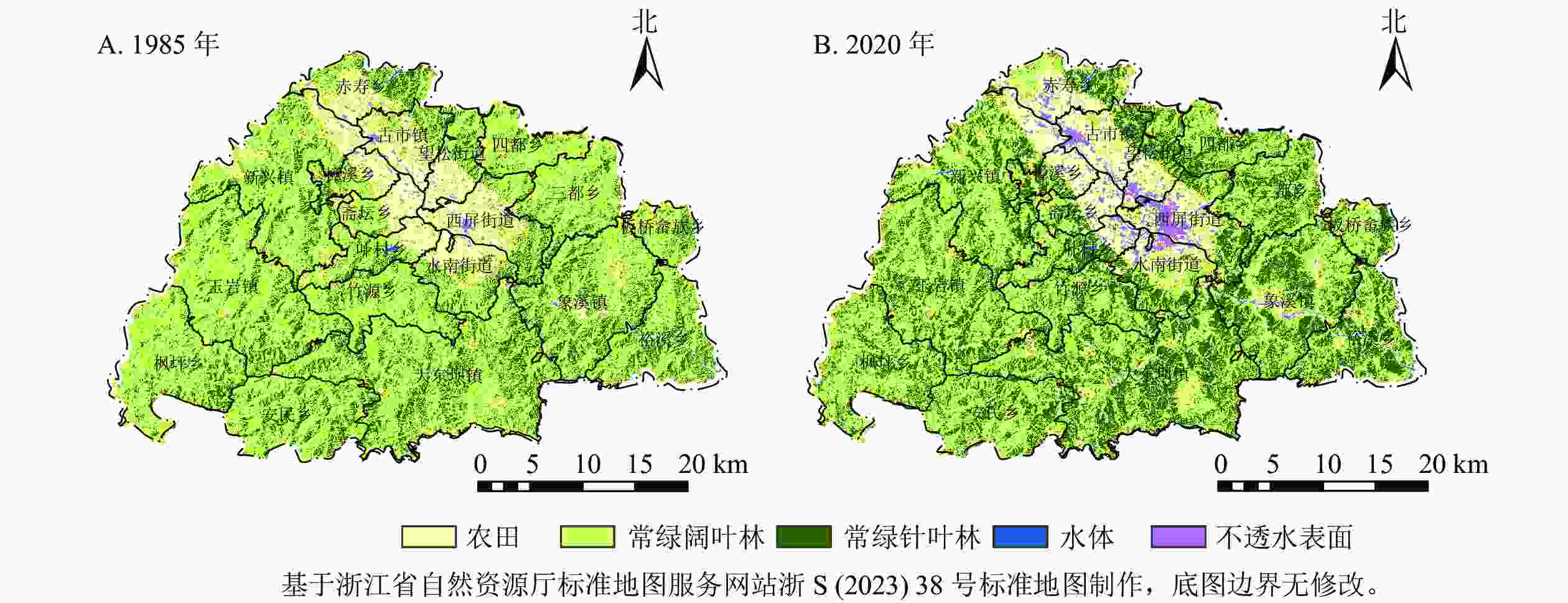
      Figure 1.  Spatial pattern of land cover in 1985 (A) and 2020 (B) of the study area

    • 森林干扰与恢复的样点数据来源于1986—2014年浙江省森林资源连续清查与谷歌高清影像目视解译。根据样点位置,结合样地的地类、树种及林龄等信息,通过目视解译来区分1987—2020年清查样点的变化情况(森林干扰、恢复、稳定)。共随机标记了100个样点,其中包括32个森林损失样点,40个森林恢复样点,其余为森林持续(未变化)样点。这些样点将用于LandTrendr分割结果的验证分析。

    • LandTrendr算法是最有效的监测森林干扰和恢复的方法之一[3839],主要通过时间序列分割算法获取影像光谱值突变和缓慢变化的信息[25, 40]。目前,LandTrendr算法移植到GEE平台后,简化了数据管理与图像预处理,作为LT-GEE算法被广泛使用[4142]。本研究采用LT-GEE来实现LandTrendr算法。

      KENNEDY等[25]与COHEN等[40]研究表明:归一化燃烧比指数(RNB)对于捕捉干扰事件具有最大敏感性,且具备较好的解释能力[25, 40]。因此,本研究使用$ {R}_{\mathrm{N}\mathrm{B}} $作为LandTrendr算法的监测指数,其计算公式为:

      式(1)中:$ {\sigma }_{\mathrm{N}\mathrm{I}\mathrm{R}} $为近红外波段反射率,反映健康绿色植被,$ {\sigma }_{\mathrm{S}\mathrm{W}\mathrm{I}\mathrm{R}2} $为短波中红外波段反射率,反映岩石和裸土。健康的森林有高的$ {\sigma }_{\mathrm{N}\mathrm{I}\mathrm{R}} $值与低的$ {\sigma }_{{\rm{SWIR2}}} $值,从而具备高的$ {R}_{\mathrm{N}\mathrm{B}} $值。一旦森林经过干扰,$ {R}_{\mathrm{N}\mathrm{B}} $将会大幅度下降。

      LandTrendr算法将对时间序列LTSS中的每个像元构建归一化燃烧比指数光谱轨迹,并利用时间序列分割算法来回归出归一化燃烧比指数光谱直线轨迹,从而识别归一化燃烧比指数急剧变化的断点并判断得到变化的年份。整个过程将识别归一化燃烧比指数值的3种特性,即整体下降(干扰)、整体增加(恢复)和整体保持不变(稳定)。LandTrendr算法在GEE上运行的具体参数设置如表1所示。分别利用LandTrendr算法对森林干扰与恢复事件进行检测,从而获得1987—2020年松阳县森林干扰与恢复发生的年份。基于森林干扰与恢复的样点数据,通过混淆矩阵计算总体精度、生产者精度、用户者精度,评估森林干扰与恢复的监测效果。

      过程参数过程参数过程参数
      分割 光谱指数 RNB 分割 恢复阈值 0.25 过滤 年份 1987—2020
      轨迹分割最大数量 6.0 拟合最大P 0.05 变化量 >200
      尖峰抑制参数 0.9 最优模型比例 0.75 持续时间 <4
      顶点数量控制参数 3.0 最小观测值数量 6.00 变化前光谱值 >300
      是否允许1 a恢复 true

      Table 1.  Parameters used in LandTrendr processing

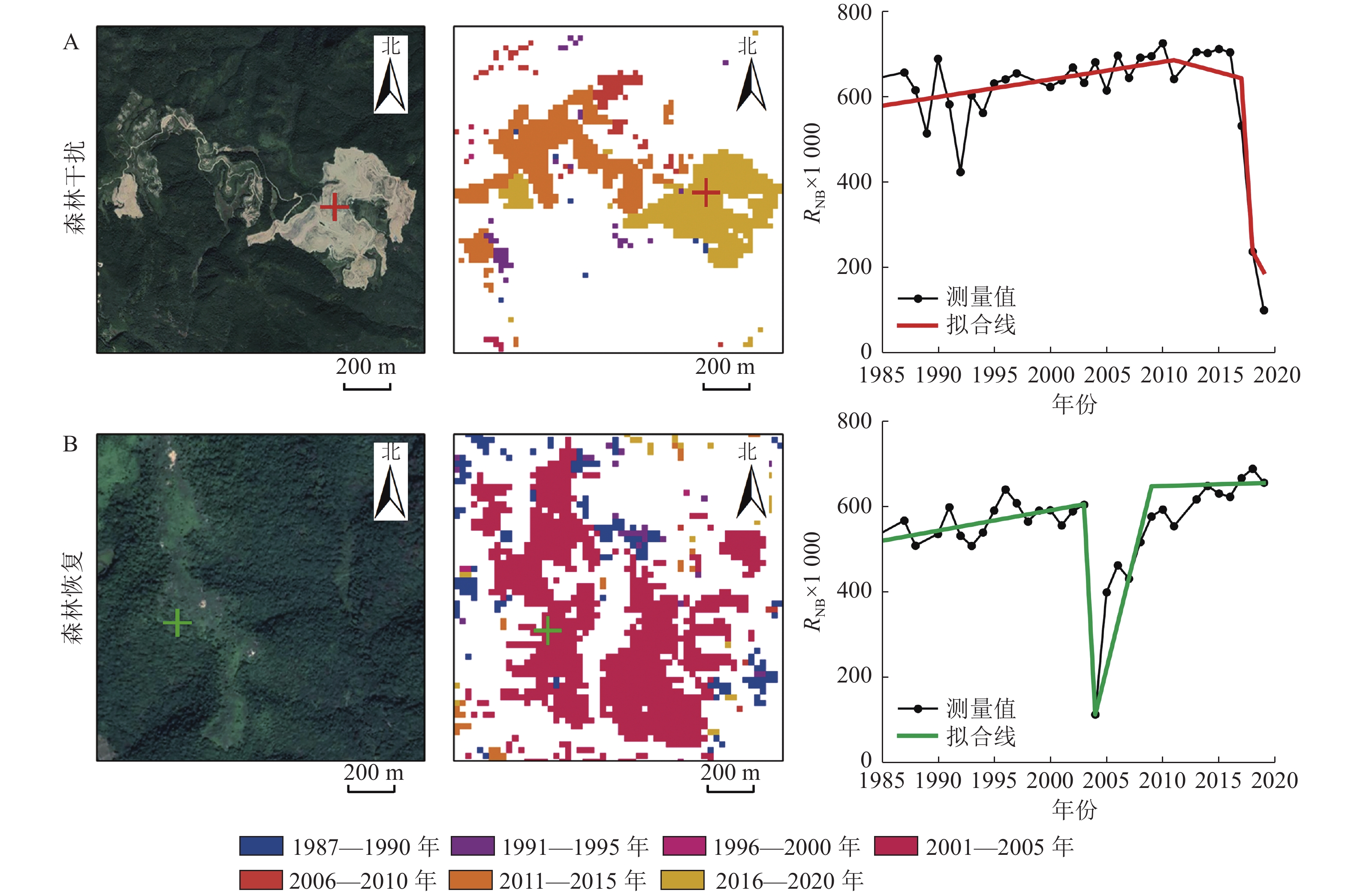
    • 图2是森林干扰与恢复监测结果的2个示例。由图2A可见:标记处RNB光谱值在2016年急剧下降,表明森林干扰发生在2016年,与LandTrendr算法计算结果一致;图2B标记处RNB光谱值在2003年开始下降,到2014年最小,并在2014年后逐渐升高,表明森林恢复发生在2004年,也与LandTrendr算法计算结果相一致。由此可见:LandTrendr算法分割的光谱轨迹可有效区分森林干扰与恢复年份。

      Figure 2.  Spectral trajectorysegmentationresults

      为了定量评估森林干扰与恢复精度,计算混淆矩阵(表2)。由表2可见:LandTrendr算法计算的总体精度达到了82.00%,森林干扰与恢复监测的生产者精度分别达87.50%、80.00%,干扰与恢复监测的用户者精度分别达84.80%、82.05%。精度均在80.00%,表明LandTrendr可以有效地监测到松阳县森林干扰与恢复情况。

      类型生产精度/%用户精度/%总体精度/%
      干扰87.5084.8082.00
      恢复80.0082.05
      稳定78.5778.57

      Table 2.  Accuracy evaluation of LandTrendr detection based on confusion matrix
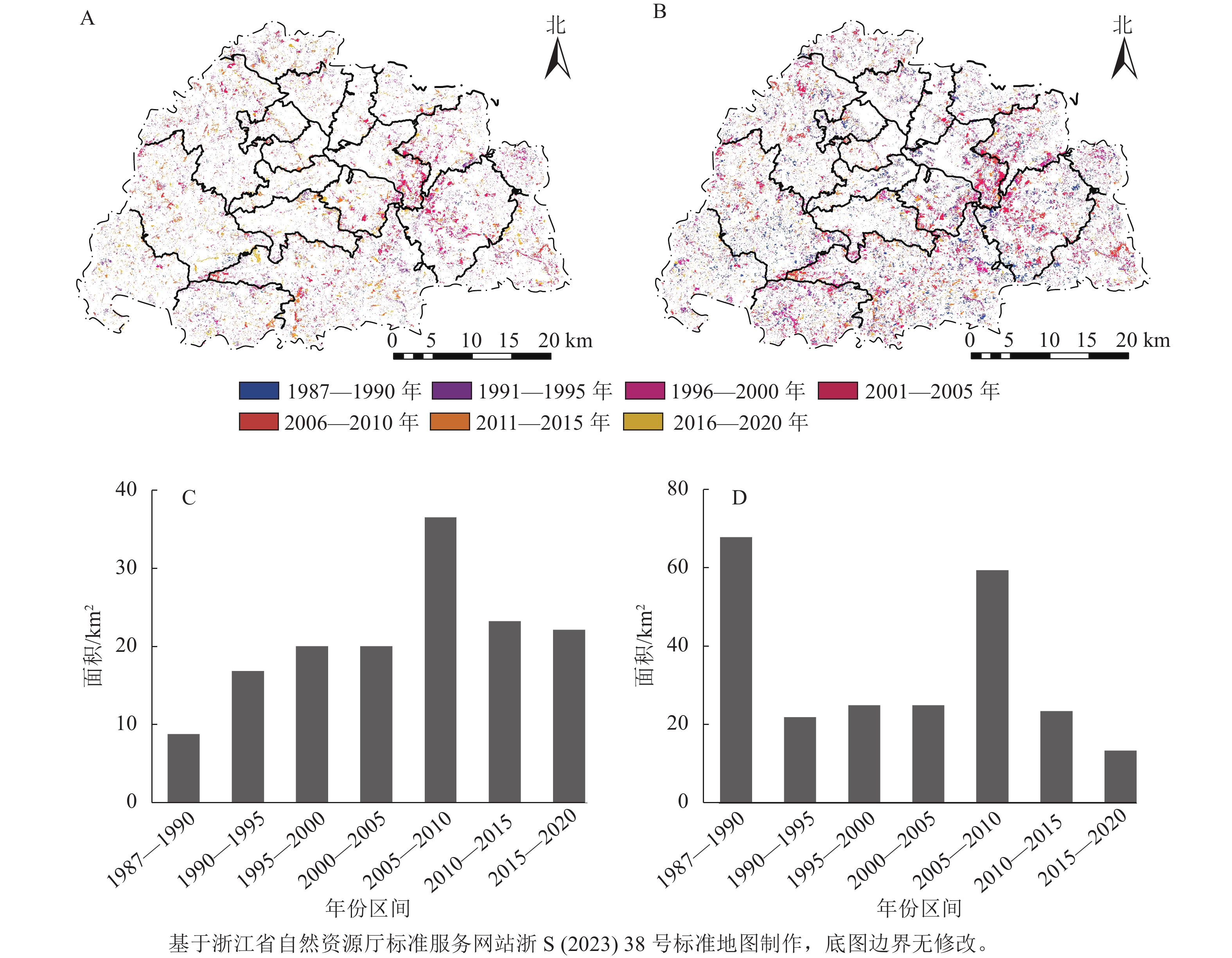
    • 图3可见:水体、非森林、持续森林已被掩膜。从空间分布上来看,1987—2020年森林干扰较为破碎,多数分布在不透水地表周边,尤其集中在松阳县东南角(如西屏街道、水南街道、象溪镇)等区域,而森林恢复在各个区域均有发生,分布较广。

      Figure 3.  Years of forest disturbance (A) and restoration (B) and areas of forest loss (C) and gain (D) in Songyang County during 1987-2020

      经统计,1987—2020年森林干扰总面积达148.14 km2,占林地面积的12.00%。其中2006—2010年森林干扰面积最高,达36.62 km2,占总干扰的24.00%。这一段时间内森林干扰严重,一方面是受松材线虫Bursaphelenchus xylophilus病影响,松阳县大量马尾松Pinus massoniana林因受侵害而被砍伐;另一方面是由于2008年松阳县受特大暴雪和冻雨灾害侵袭,森林资源损失严重[43]。而1987—2020年森林恢复总面积达236.86 km2,占林地面积的20.37%。其中1987—1990和2006—2010年森林恢复面积较高,分别达67.90和59.55 km2,占总森林恢复的28.67%和25.14%。1987—1990年森林恢复主要原因是改革开放后退耕还林、植树造林等重大工程项目的实施,而2006—2010年森林恢复主要是因为自2008年雪灾后的2009与2010年森林自然更新与人为再造林。

      除森林重大受灾或国家重大植树造林工程展开的年份外,松阳县隔5 a的森林干扰与恢复面积一般稳定在20.00~30.00 km2。整体上,松阳县森林恢复面积高于森林干扰面积,森林面积呈现逐渐增加趋势。

    • 表3可见:各乡(镇)在1987—2020年森林总干扰面积为1.62~25.96 km2,总恢复面积为2.43~46.00 km2。各个乡(镇)总恢复面积均高于总干扰面积,说明1987—2020年各乡(镇)森林总面积净增长。其中,大东坝镇、板桥畲族乡、新兴镇、玉岩镇总恢复面积远远高于总干扰面积,森林面积分别增加了20.04、11.03、10.33、8.49 km2。这些乡(镇)位于山地丘陵,自然林和公益林较多,受自然灾害与人为破坏后,森林自然更新以及造林再造林活动等促使了森林大量恢复。位于松阳县平原且人类活动频繁的城镇中心,如往松街道、古市镇、斋坛乡、樟溪乡等乡(镇)森林干扰面积与恢复面积相当,森林面积增加较少。

      乡(镇)森林面积/km2乡(镇)森林面积/km2乡(镇)森林面积/km2
      干扰面积恢复面积干扰面积恢复面积干扰面积恢复面积
      大东坝镇 25.96 46.00 裕溪乡 9.89 14.57 玉岩镇   15.10 25.43
      望松街道 1.62 3.84 三都乡 9.05 14.44 竹源乡   5.40 8.60
      水南街道 6.63 10.61 古市镇 3.31 4.63 板桥畲族乡 3.54 5.52
      西屏街道 8.86 14.22 斋坛乡 2.01 2.43 象溪镇   16.04 27.07
      叶村乡  2.60 5.03 新兴镇 14.00 21.64 赤寿乡   6.73 8.00
      四都乡  3.40 6.16 枫坪乡 8.04 13.84
      安民乡  9.41 17.91 樟溪乡 2.11 3.74

      Table 3.  Statistics of forest disturbance and restoration area at township level in Songyang County

    • LandTrendr算法的主要思想是从Landsat时间序列数据中提取归一化燃烧比指数等光谱变化轨迹,并分割轨迹及线性拟合,去除光谱尖峰噪音信息,将复杂的变化特征简化为几段光谱直线,以此来突出变化时刻断点,从而捕获时间序列数据的干扰与恢复信息。本研究利用LandTrendr算法有效地提取了1987—2020年浙江省松阳县森林干扰与恢复发生年份,精度均在70%以上,表明LandTrendr算法可有效监测松阳县森林变化。LandTrendr算法不仅能够监测干扰年份,同时也能够监测干扰量[11, 19]。已有研究通过干扰量来区分干扰类型,以及识别主要与次要干扰的分布,或者划分森林干扰与恢复等级[11, 19, 25, 34]。以往采用最佳的单一指数作为LandTrendr算法监测,不同指数运行好坏的贡献未知,监测效果好坏不一。当前,利用LandTrendr算法完善森林干扰与恢复的研究越来越全面,LandTrendr算法综合多波段、多光谱指数的监测方法已得到很好应用,监测效果要优于单一指数监测效果[4446]。后续,可以尝试利用多光谱指数,结合LandTrendr监测干扰与恢复变化量来识别松阳县森林主要与次要干扰,区分干扰强度,从而提出相应措施减少森林主要干扰,避免森林急剧减少。

      本研究采用的验证方法为基于样地的目视解译。经目视解释可知:松阳县森林干扰类型多为人工采伐以及台风雪灾等自然灾害,恢复类型多为人工造林等,但并没有通过LandTrendr进行具体的类型划分。后续,可结合其他技术手段对干扰与恢复类型进行区分,并优化验证方法。目前,国外研究多采用Timesync工具来验证LandTrendr算法,这种工具可自动获取解译结果,并与算法分割结果作比较[8, 25]。综合现有结果分析,尽管本研究尚未能分析出松阳县森林干扰与恢复的类型和强度,但可有效监测森林干扰与恢复发生的年份,并分析了松阳县森林变化情况,为松阳县森林经营管理提供相应参考数据。

    • 本研究采用GEE云平台的LandTrendr算法监测浙江省松阳县1987—2020年森林干扰与恢复状况,并进行森林干扰与恢复时空特征分析。结论如下:①LandTrendr算法监测森林干扰与恢复的总体精度达到了82%,森林干扰与恢复的生产者精度用户精度均高于80%,表明松阳县森林干扰与恢复监测效果较好。②松阳县森林干扰与恢复总面积分别为148.14与236.86 km2,分别占林地面积的12.74%、20.37%,表明松阳县1987—2020年森林面积呈净增加趋势。③松阳县大东坝镇、板桥畲族乡、新兴镇、玉岩镇森林面积变化较为频繁,森林干扰与恢复面积均比其他乡(镇)高。大东坝镇森林面积变化最大,增加了20.04 km2

Reference (46)

Catalog

    /

    DownLoad:  Full-Size Img  PowerPoint
    Return
    Return