


-
胸径和树高是各类森林资源调查的重要测树因子,是获取林分蓄积量、生物量、碳储量等信息的基础变量[1]。在传统地面调查中,胸径可以利用测径围尺量测,树高则需借助测高器、激光枪等设备测量。因林分内树冠遮挡视线难以快速测量,一般按径阶绘制树高曲线,以胸径实测值查找相对应的树高值[2],需要耗费大量财力物力,效率低下。
激光雷达(light detection and ranging,LiDAR)扫描技术以激光脉冲的形式获取单木位置、树高和胸径等三维信息的优势,在森林资源调查领域得到快速发展[3−4]。背负式LiDAR (backpack laser scanning,BLS)作为激光雷达产品的典型代表之一,与地基式LiDAR (terrestrial laser scanning, TLS)相比更便携,更高效。背负式LiDAR能够结合同步定位与地图构建(simultaneous localization and mapping,SLAM)算法,采集不同尺度、不同地形的林下高精度三维点云信息[5−7]。李丹等[8]基于地基式LiDAR数据,提取了红松Pinus koraiensis的胸径和树高,发现胸径估测效果较好,决定系数(R2)为0.91,树高估测效果较差,R2为0.48。黄旭等[9]基于背负式LiDAR提取了落叶松Larix olgensis的胸径和树高,提取精度分别为94.51%、80.27%,显示背负式LiDAR胸径提取优势显著高于树高。无人机机载LiDAR (unmanned aerial vehicle laser scanning,ULS)具有获取树冠上层三维信息的显著优势[10]。基于冠层高度模型(canopy height model,CHM)的图像分割和基于归一化点云空间聚类的点云分割是无人机机载LiDAR单木分割的典型方法[11−12]。陈思宇等[13]比较了基于点云空间特征和基于冠层高度模型的单木分割方法,发现利用点云空间特征能够避免冠层高度模型插值产生的栅格误差,点云聚类算法进行单木分割时存在距离阈值类似的情况,从而影响提取结果。朱泊东[14]利用无人机机载LiDAR获取冠层高度模型和归一化点云,采用CHM分水岭分割法、基于点云局部最大值聚类算法和基于层堆叠种子点的点云分割法进行单木分割,表明在低郁闭林分中CHM分水岭分割算法单木提取效果较好,而在高郁闭林分,基于层堆叠种子点的点云分割效果较好。POLEWSKI等[15]利用相似度函数特征点匹配,实现对无人机机载LiDAR和背负式LiDAR点云的精配准。张信杰等[16]融合背负式LiDAR和无人机机载LiDAR数据,提取树高信息,发现得益于无人机机载LiDAR获取冠上加密点云的优势,融合点云的树高提取精度明显优于背负式LiDAR点云。背负式LiDAR由下而上获取点云,无人机机载LiDAR由上而下获取点云,两者互补能够获取高精度树高和胸径结果。
本研究以云南松Pinus yunnanensis天然纯林为对象,获取背负式LiDAR和无人机机载LiDAR扫描数据,通过LiDAR360 MLS和LiDAR360软件进行单木分割,从背负式LiDAR点云中提取胸径和树高,同时,通过融合背负式LiDAR和无人机机载LiDAR数据获取能够表征林分三维结构的点云,实现高精度地提取树高和胸径。以期建立一种精准、高效的胸径和树高信息估算方法,旨在为今后各类森林资源调查提供可信度高、成本低、效率高的技术手段。
-
研究区位于云南省昆明市富民县罗免乡黄草坝(25°21′35.3″~25°24′8.3″N,102°27′36.5″~102°30′50.9″E)。该区属亚热带季风气候,年平均气温为16.3 ℃,年平均降水量为854.0 mm。森林资源丰富,全县森林覆盖率为62.97%。研究区为云南松天然林封山育林区,区内的森林资源以云南松天然纯林为主。
-
外业调查工作于2023年11月完成。在全面踏查的基础上,选取具有充分代表性的典型成熟云南松天然纯林,设置6个半径为15.0 m的圆形样地,测定胸径≥5.0 cm活立木的单木位置、树高、胸径[17],由全球定位系统(GPS)获取样地中心位置坐标,用皮尺测量被测木到样地中心点的方位角和水平距,确定每木定位信息,共获取118株云南松样木数据。表1为样木胸径和树高调查结果。
样地编号 优势树种 林木株数 胸径/cm 树高/m 最小值 最大值 平均值 标准差 最小值 最大值 平均值 标准差 1 云南松 23 6.2 33.3 18.6 6.1 1.9 12.9 8.0 2.3 2 云南松 15 13.7 30.4 21.2 4.9 6.8 11.0 8.9 1.4 3 云南松 23 9.6 34.7 19.1 7.0 3.1 12.0 8.0 2.1 4 云南松 25 6.8 30.2 18.1 5.6 3.7 11.1 7.5 1.8 5 云南松 15 9.2 33.3 19.9 6.3 4.3 12.6 8.1 2.1 6 云南松 17 5.8 35.6 20.4 7.5 3.3 13.1 9.1 2.7 Table 1. Statistics of the sample plots
-
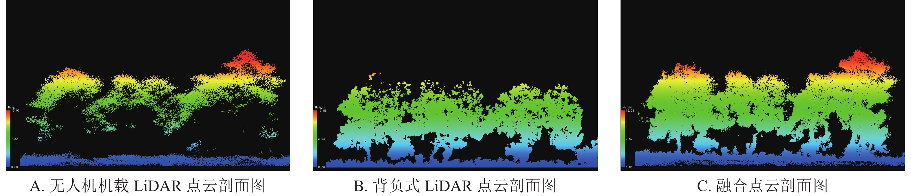
利用搭载LiAir220N激光雷达系统的大疆M300 RTK无人机[配置高精度全球导航卫星系统(global navigation satellite system,GNSS)和惯性测量单元(inertial measurement unit,IMU)],于2023年11月完成外业采集工作。飞行高度为150 m (仿地飞行),飞行速度为4 m·s−1,航向和旁向重叠率均设置为70%,共获取了覆盖6个圆形样地的无人机机载LiDAR点云数据,平均点云密度为2 818点·m−2。同时,利用LiBackpack DGC50背负式LiDAR三维扫描系统(配置水平和垂直2个LiDAR传感器及高精度GNSS设备)进行背负式LiDAR数据的同步采集。系统参数如下:LiDAR传感器为VLP16,激光器扫描距离为100 m,激光波长为903 nm,相对精度为≤3 cm,垂直视场角为−90°~90°,水平视场角为0°~360°。采集人员对各圆形样地按“Z”字形路线图缓慢行进采集数据,行进速度为1 m·s−1。为保证样木胸径的圆拟合,扫描样木两侧,获取树干完整信息。此外,为采集边缘木两侧的数据,路线范围略大于样地范围,共获取了覆盖6个圆形样地的背负式LiDAR点云数据,平均点云密度为18 453点·m−2。由图1可见:无人机机载LiDAR系统由上而下获取点云数据(图1A),受激光束回波次数和枝叶遮挡激光束的影响,林冠中上层密度远高于林下,冠上树顶点信息明显,但树干点云信息缺失严重。背负式LiDAR系统由下而上获取点云数据(图1B),其树干点云较无人机机载LiDAR点云清晰,受回波次数、扫描角度和枝叶遮挡的影响,冠上点云信息明显缺失。
Figure 1. Profile of point clouds
-
将背负式LiDAR点云数据进行去噪、点云分类、归一化和单木分割等处理,其中LiDAR360软件对于高程信息的分类是在地面点分类的基础上,进行高于地面的点云分类,设置2个高程阈值,即高度0~1.3 m的低矮植被(灌草)和1.3~20.0 m的中等植被(林木);利用LiDAR360 MLS软件进行深度学习分类,GV_Forest_HLS模型可基于形态学原理,将背负式LiDAR点云数据分为地面点、低矮植被、树干和树冠等类别,通过类别设置将点云数据的类别属性映射到不同颜色值,直观地区分不同类别的点云数据。配合手动编辑分类,将需要修改的点云颜色映射为目标类别颜色。设置点云切片厚度为0.2 m,获取1.2~1.4 m高度的树干圆柱体,通过拟合圆的方式拟合胸径提取种子点,并将基于分类获取的树干和树冠2个点云类别作为单体点进行单木分割,最后在单木分割的基础上对提取的胸径和树高异常值进行手动测量修正。利用LiDAR360软件提供的基于种子点分割方法对无人机机载LiDAR点云进行单木分割。基于种子点分割主要包括种子点选取和分割,主要步骤包括基于归一化点云进行点云分割作为1次分割,提取种子点;利用机载林业模块的种子点编辑功能修正种子点后,进行基于种子点分割的2次分割。
无人机机载LiDAR具有绝对坐标信息,而背负式LiDAR由于树冠遮挡和GPS信号微弱,仅有相对坐标信息,通过LiFuser-BP软件进行全球导航卫星系统(GNSS)轨迹处理和SLAM解算可获取带有绝对坐标的背负式LiDAR点云数据。由于背负式LiDAR与无人机机载LiDAR在GNSS定位误差、获取方式及视角上存在差异,需将无人机机载LiDAR点云作为参考数据,背负式LiDAR作为待配准数据进行粗配准,并利用迭代最近点算法(iterative closest point,ICP)进行精配准,获取完整冠层点云信息。为提高配准运行速度,消除地物噪声,对背负式LiDAR点云进行50%采样率的重采样处理,点云融合后点云进行二次去噪处理,平均点云密度为10 671点·m−2,融合点云剖面图如图1C所示。ICP算法本质上是基于最小二乘法选择参考点云(Ps)和待配准点云(Pt)的最近对应点,迭代平移矩阵t和旋转矩阵R,重复i次平移t和旋转R过程直至收敛,获取最优变换矩阵(R*,t*)完成配准[18]。配准后的点云采用与背负式LiDAR点云相同的分割方法提取胸径和树高信息。配准后的同名点对坐标差值如表2所示,X和Y方向表示点对在水平方向的坐标,Z方向表示点对垂直方向的高程。各方向坐标距离差值较小,点对坐标的均方根(ERMS)为0.326 m,配准效果较好。
点对 X/m Y/m Z/m 目标点 参考点 差值 目标点 参考点 差值 目标点 参考点 差值 P0 246 951.78 246 952.09 −0.31 2 809 652.76 2 809 652.23 0.53 2 145.12 2 144.86 0.26 P1 246 964.23 246 964.17 0.06 2 809 657.58 2 809 656.73 0.85 2 146.89 2 146.97 −0.08 P2 246 960.83 246 960.94 −0.11 2 809 647.25 2 809 647.43 −0.18 2 144.64 2 144.40 0.24 P3 246 962.89 246 963.16 −0.27 2 809 640.78 2 809 640.67 0.11 2 145.68 2 145.86 −0.18 P4 246 965.49 246 964.96 0.53 2 809 645.85 2 809 645.44 0.41 2 144.43 2 144.72 −0.29 P5 246 974.35 246 974.42 −0.07 2 809 647.07 2 809 646.91 0.16 2 144.83 2 144.80 0.03 Table 2. Coordinate difference after registration
式(1)中:R*为最优平移矩阵;t*为最优旋转矩阵;Ps为参考点云点集合;${{P}}_{\rm{t}}^i $为平移和旋转待配准点云点集合;R为平移矩阵;t为旋转矩阵。
-
单木分割是胸径和树高等单木参数提取的基础。为比较不同分割方法单木分割的效果,与每木位置进行对比分析,采用准确率(Pd)、召回率(Pr)和F测度(F)评价单木分割精度[19]。
式(2)~(3)中:Nc为分割正确的株数;Nd为分割提取株数;Nr为实测参考株数。
-
利用决定系数(R2)、均方根误差(ERMSE)对回归模型的拟合效果进行评价,确定估测值与实测值之间的吻合程度和估测的准确度[20]。
式(5)~(6)中:$ {y}_{i} $为实测值;$ {\hat{y}}_{i} $为估测值;$ \overline{y} $为实测平均值;n为样本数。
-
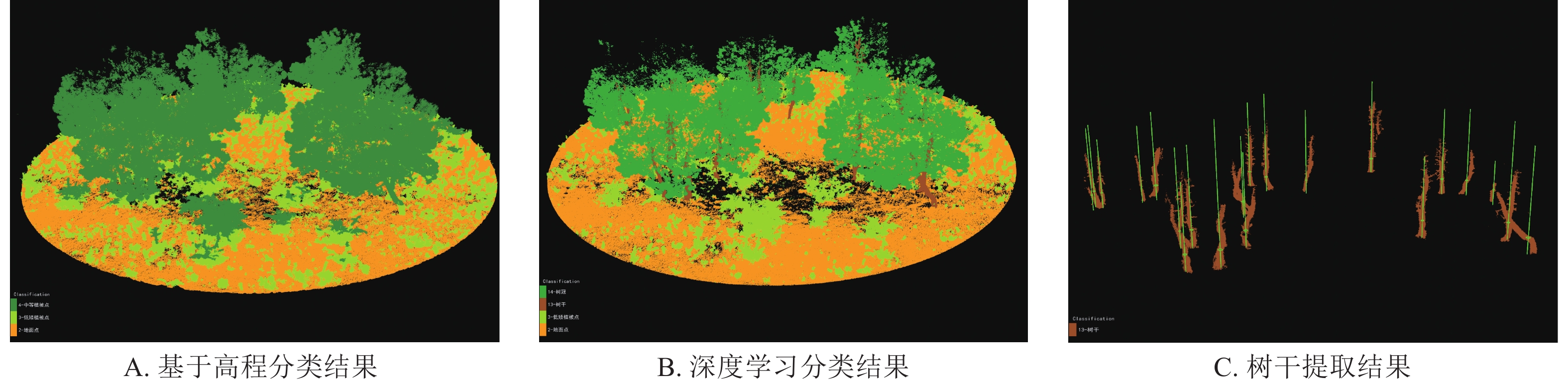
图2为1号样地的背负式LiDAR分类结果。图2A表明:LiDAR360基于高程分类仅将树干与树冠分为1个类别,设置1.3 m的低矮植被点高程阈值,发现样地内部灌木被错误分类为中等植被点(林木)。单木分割时,易受灌草的影响,软件自动在1.3 m处将拟合圆作为胸径拟合结果,导致灌草的冠径被错误识别成胸径。图2B为LiDAR360 MLS基于形态学的深度学习分类结果。相较LiDAR360,LiDAR360 MLS能够将灌草和林木进行有效分类,有效避免高度大于1.3 m灌草的影响,将点云分为地面点、低矮植被点、树干和树冠4个类别。图2C为树干提取结果,效果较好。通过树干提取可实现胸径的高精度拟合,并准确获取与实测相吻合的样木株数,单木提取率达100%。因此,本研究采用LiDAR360 MLS对背负式LiDAR和融合数据进行单木分割,提取胸径和树高信息。

Figure 2. Point cloud classification results of backpack laser scanning (BLS)
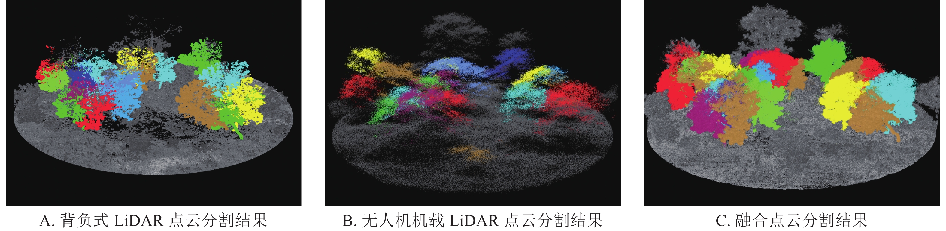
由图3和表3的单木分割结果可见:由于分类时可提取树干信息,样木均被分割提取。背负式LiDAR点云和融合点云的树干提取和单木分割效果相似,召回率均达100%。实测时仅获取达到起测径阶的云南松树种的实测信息,但根据踏查发现样地内存在少数栎类树种和未达到起测径阶的云南松幼树,仅依靠点云信息难以区分云南松和其他树种,因此借助背负式LiDAR点云及融合点云提取株数略大于参考株数。无人机机载LiDAR点云主要依赖点云空间聚类进行分割,树冠形状和分布一定程度上会影响单木分割结果,样地内样木分布不均匀,1.3 m以下树干分叉现象明显,相邻样木树冠重叠,枝杈复杂,易出现欠分割和过分割现象。但总体而言,无人机机载LiDAR点云分割漏分和错分比例较少,准确率、召回率和F测度分别为94.59%、88.98%、91.70%。

Figure 3. Comparison of individual tree segmentation results
数据类型 参考株数/株 提取株数/株 正确分割株数/株 漏分株数/株 错分株数/株 单木分割精度评价结果 准确率/% 召回率/% F测度/% 背负式LiDAR 118 126 118 0 0 93.65 100.00 96.72 无人机机载LiDAR 118 111 105 7 6 94.59 88.98 91.70 融合点云 118 126 118 0 0 93.65 100.00 96.72 Table 3. Individual tree segmentation verification
-
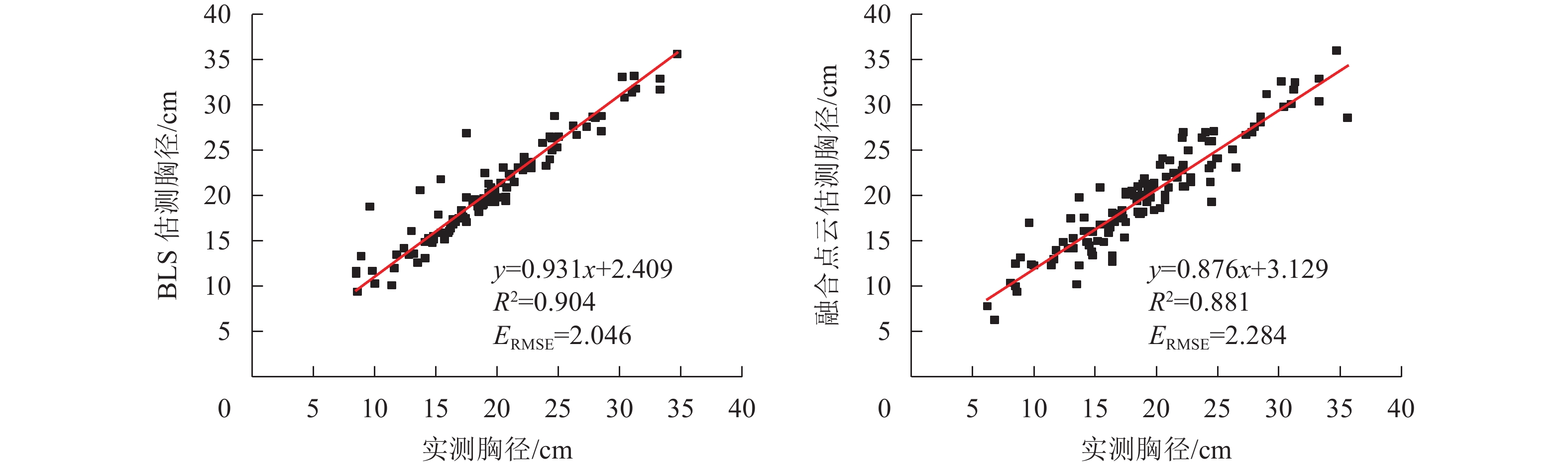
背负式LiDAR和融合点云均可同时获取胸径和树高估测值。由图4的回归拟合结果发现:从应用LiDAR360 MLS软件单独提取的背负式LiDAR数据结果看,胸径提取精度较高,R2和ERMSE分别为0.904和2.046 cm,利用融合点云提取胸径的R2和ERMSE分别为0.881和2.284 cm。融合后受无人机机载LiDAR点云的影响,树干附近的点云噪点增加,与单独使用背负式LiDAR提取胸径相比,精度没有有效提升。

Figure 4. Results of DBH linear regression
-
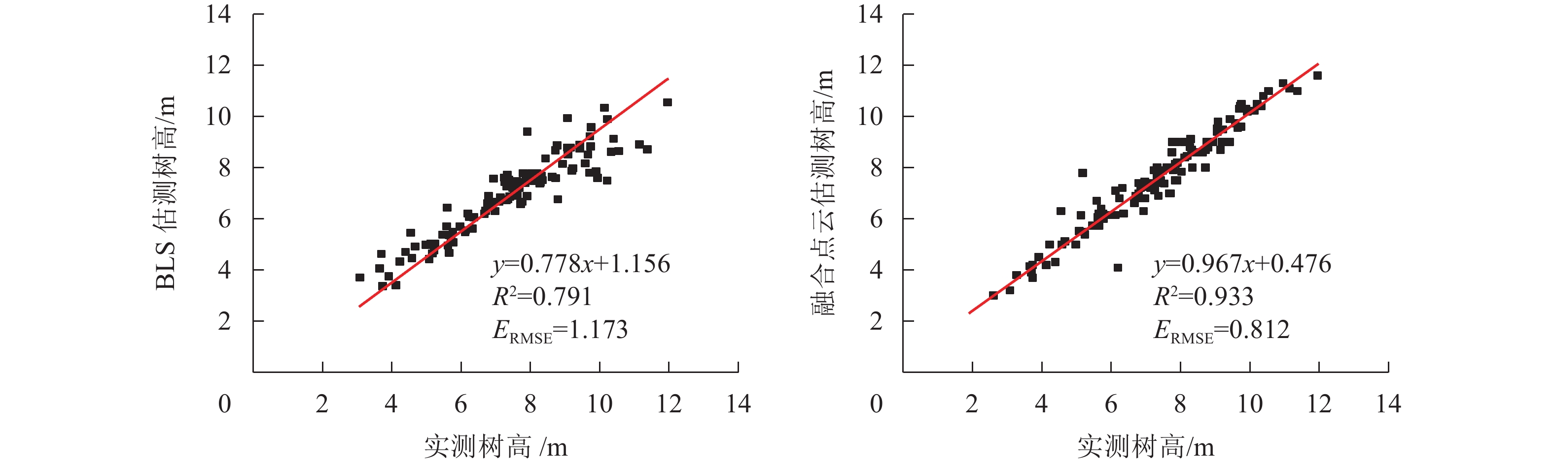
如图5所示:融合无人机机载LiDAR点云后,提取树高的R2相对于背负式LiDAR提升了0.142,主要原因为样地内样木簇生情况明显,且分布不均匀。由于枝叶遮挡、视场角及回波次数限制,背负式LiDAR的树冠上层点云存在一定程度的缺失,提取树高的R2和ERMSE分别为0.791、1.173 m,反映出单独利用背负式LiDAR提取树高存在不足。无人机机载LiDAR与背负式LiDAR点云的融合,结合了无人机机载LiDAR冠上点云获取的优势和背负式LiDAR林下点云获取的优势,通过几何测量计算冠顶点至地面点的垂直高度,树高估测结果准确度更高,R2和ERMSE分别为0.933、0.812 m。

Figure 5. Results of tree height linear regression
-
无人机机载LiDAR是通过树冠分割和树顶点提取实现单木分割,欠分割和过分割现象明显,而利用深度学习提取背负式LiDAR点云的树干和树冠作为单体进行单木分割,提取率可达100%。本研究基于背负式LiDAR数据利用LiDAR360 MLS软件提取的胸径和树高结果发现:胸径提取精度较高,R2可达0.904,树高提取精度较低,R2仅为0.791。无人机机载LiDAR难以穿透冠层获取树干信息,主要适用于提取冠层信息实现树高信息的高精度提取,进而与实测胸径构建反演模型,实现胸径的估测。背负式LiDAR获取的树干信息完整,胸径提取精度较高,但难以穿透冠层获取树顶端点云,因此树高低估程度较大。GAO等[21]对无人机机载LiDAR采取面向点云的距离判断聚类算法进行单木分割,提取水杉Metasequoia glyptostroboides树高,F测度为90.00%,树高的R2和ERMSE分别为0.913、0.849 m;对背负式LiDAR点云采取基于密度的噪声应用空间聚类(DBSCAN)算法进行单木分割,提取精度较高,F测度为93.00%,胸径的R2和ERMSE分别为0.945、0.013 cm,证明无人机机载LiDAR提取树高和背负式LiDAR提取胸径的显著优势。
本研究融合2种LiDAR点云数据,基于单木分割,提取树高的R2和ERMSE分别为0.933和0.812 m,提取胸径的R2和ERMSE分别为0.881和2.284 cm。受无人机机载LiDAR点云的影响,融合后在树干附近的点云噪点增加,与单独使用背负式LiDAR提取胸径相比,精度没有得到有效提升。代婷婷[22]比较了地基式LiDAR、融合地基式LiDAR与无人机机载高分辨率影像运动恢复结构(structure from motion,SFM)三维重建点云的树高提取值,发现融合点云提取的树高更精准,相关系数(r)达0.999。无人机机载SFM三维重建点云通过正射图像三维重构获取,仅生成冠层点云,对1.3 m处树干的胸径提取影响较小,因此融合点云与地基式LiDAR点云相比,胸径提取值差异不大。朱俊峰等[23]研究表明:由于无人机飞行高度(550 m)较高、飞行速度(96 km·h−1)较快、旁向重叠率(20%)较低等原因,无人机机载LiDAR点云密度较低,地基式LiDAR和无人机机载LiDAR融合点云相对于地基式LiDAR提取的树高精度提升不明显,R2由0.804提升至0.809,且两者ERMSE均较大,分别为3.29和3.32 m。FEKRY等[24]融合了无人机机载LiDAR和背负式LiDAR数据,提取的树高相对均方根误差(rRMSE)与单独使用背负式LiDAR相比,下降了9.01%,但胸径提取的rRMSE提升了0.5%,因此融入无人机机载LiDAR对提取胸径没有提升,反而增加了树干周围的噪点。在点云配准过程中,目前主要是依靠2种点云的树冠轮廓进行匹配,但由于相邻木树冠重叠或林分密度过大使冠形不明显,因此依靠冠形进行配准存在一定的不确定性。无人机机载LiDAR是正射推扫获取点云,而背负式LiDAR是垂直获取点云,冠形存在一定差异,通过冠形有时难以提供准确的特征点。SHAO等[25]通过配准无人机机载LiDAR、背负式LiDAR和地基式LiDAR等3种数据发现:林分密度越大,通过树冠轮廓匹配寻找对应特征点越困难,地形起伏容易影响地面点配准,但本研究样地范围内地形平缓,可忽略这种影响。
利用LiDAR360软件进行胸径自动拟合发现:云南松树干形状较不规则,不属于树干的目标(如灌木和枝叶)也被识别为代表胸径结果的圆。目前主要有圆形拟合、椭圆拟合和圆柱体拟合3种胸径拟合方式,在拟合不规则树干的胸径时均存在较大的拟合误差,需要一种能够适用于不规则形状树干,并能剔除灌木的胸径识别算法,以增加近地LiDAR扫描技术估测森林参数,替代部分样地实测的潜能。徐华东等[26]利用Hough变换法和连续生长算法提取蒙古栎Quercus mongolica的胸径,发现非规则圆形或椭圆形树干容易影响胸径的拟合效果。此外,刘鲁霞等[27]和邱琴等[28]分别基于地基式LiDAR和背负式LiDAR扫描数据,对比了天然林和人工林的胸径拟合和树高提取效果,发现人工林的胸径和树高提取精度明显优于天然林。主要原因在于人工林的林分条件单一,林分密度低,容易探测到树顶点,树干通直,林下灌草较少,胸径拟合结果较准确;天然林中林分复杂,林分密度较高,受枝叶和相邻树木部分遮挡,难以穿透枝叶探测树顶点;林下灌草会被错误识别成林木,树干弯曲情况严重,胸径拟合结果易受影响。本研究利用LiDAR360 MLS软件有效区分了灌草、树干和树冠,并在树干1.3 m处拟合胸径,有效避免了灌草的影响,但1.3 m处树干形状不规则仍然会造成一定程度胸径拟合异常,需要手动修正重新拟合,获取高精度胸径拟合结果。
-
基于背负式LiDAR的LiDAR360 MLS深度学习分类能够有效提取树干和树冠,通过树干1.2~1.4 m处点云切片可以较准确地拟合胸径,利用树干和树冠作为单体进行单木分割,提取单木株数与实际基本吻合,分割效果较好,能够有效地获取高精度的胸径和树高信息。背负式LiDAR和无人机机载LiDAR分别采用自下而上和自上而下的观测模式获取三维点云数据。背负式LiDAR能获取精确林下信息,在提取胸径信息时具有显著优势,但获取的冠层信息不完整,容易低估树高信息。无人机机载LiDAR获取的冠层信息较为完整。通过ICP算法寻求对应点,融合背负式LiDAR和无人机机载LiDAR能够更完整地描述森林空间结构,同步获取高精度的胸径和树高信息,更好地运用于森林资源调查。
Extraction of DBH and height of Pinus yunnanensis individual trees by combining backpack laser scanning and unmanned aerial vehicle laser scanning
doi: 10.11833/j.issn.2095-0756.20240107
- Received Date: 2024-01-04
- Accepted Date: 2024-05-08
- Rev Recd Date: 2024-05-07
- Available Online: 2024-09-25
- Publish Date: 2024-09-25
-
Key words:
- backpack laser scanning (BLS) /
- unmanned aerial vehicle laser scanning (ULS) /
- individual tree segmentation /
- Pinus yunnanensis
Abstract:
| Citation: | XU Shanshan, LI Changchun, ZHANG Chao. Extraction of DBH and height of Pinus yunnanensis individual trees by combining backpack laser scanning and unmanned aerial vehicle laser scanning[J]. Journal of Zhejiang A&F University, 2024, 41(5): 939-948. DOI: 10.11833/j.issn.2095-0756.20240107

|
 DownLoad: