Turn off MathJax
Article Contents

LIU Shihao, HU Wen, YANG Yanggu, et al. Estimation of fine dead fuel load based on Random Forest Model[J]. Journal of Zhejiang A&F University, 2025, 42(X): 1−9 doi:  10.11833/j.issn.2095-0756.20240386
Citation: LIU Shihao, HU Wen, YANG Yanggu, et al. Estimation of fine dead fuel load based on Random Forest Model[J]. Journal of Zhejiang A&F University, 2025, 42(X): 1−9 doi:  10.11833/j.issn.2095-0756.20240386

OnlineFirst articles are published online before they appear in a regular issue of the journal. Please find and download the full texts via CNKI.

Estimation of fine dead fuel load based on Random Forest Model

DOI: 10.11833/j.issn.2095-0756.20240386
  • Received Date: 2024-06-05
  • Accepted Date: 2024-12-13
  • Rev Recd Date: 2024-11-26
  • Available Online: 2025-02-28
  •   Objective  The objective is to study the estimation method and spatial distribution of fine dead fuel load on the ground surface.   Method  Based on remote sensing data and field survey results, a Random Forest Model was employed to estimate the land surface fine dead fuel load in 172 standard plots of arboreal forests and bamboo forests in Anhua County, Hunan Province, and the importance of each factor in the estimation process was analyzed.   Result  (1) The Random Forest Model had high accuracy in estimating the surface fine dead fuel load. The determination coefficients (R²) on the training set and validation set were 0.930 and 0.724 respectively, and the root mean square errors were 0.2623 and 0.4166 t·hm−2 respectively, both of which passed the confidence test at 0.01 level. (2)There were significant differences in the importance of each factor in the estimation process, and the importance index ranking from the largest to the smallest was vegetation type factor (39.95%), stand factor (7.23%), terrain factor (3.91%) and spectral feature index factor (3.82%). (3) The surface fine dead fuel load in Anhua County was 1.18−6.19 t·hm−2, and the areas with high fuel load were mainly concentrated in Jiangnan Town, Tianzhuang Township, Malu Town, Yanxi Town, Le’an Town, Meicheng Town, and Taoxi Town.   Conclusion  The Random Forest Model can be well applied to estimate the surface fine dead fuel load, and can provide a reliable method for regional forest management and conservation, as well as for forest fire risk mitigation. [Ch, 4 fig. 2 tab. 31 ref.]
  • [1] WU Qinjiao, SONG Yandong, TAO Shijie, WANG Li, ZHOU Ruyi, CHEN Wu, PAN Xinhe, ZHOU Yufeng, ZHOU Guomo.  VOCs release characteristics of 5 typical stands in Baiyun National Forest Park and their relationship with environmental factors . Journal of Zhejiang A&F University, doi: 10.11833/j.issn.2095-0756.20220676
    [2] JIA Yujie, LIU Yungen, YANG Silin, WANG Yan, ZHANG Chao, XU Hongfeng, ZHENG Shujun.  Applicability of land use classification method in Dali City based on Sentinel-2A image . Journal of Zhejiang A&F University, doi: 10.11833/j.issn.2095-0756.20220134
    [3] JIAN Yongqi, WU Jiasen, SHENG Weixing, NIE Guohui, ZHENG Cheng, JIANG Peikun.  Effects of thinning and stand types on litter stock and soil water-holding capacity . Journal of Zhejiang A&F University, doi: 10.11833/j.issn.2095-0756.20200355
    [4] WU Lizhou, WANG Xiaohui, WANG Zhihui, FANG Xin, ZHU Tingyu, DING Lixia.  Crops identification based on hyperspectral data and random forest method . Journal of Zhejiang A&F University, doi: 10.11833/j.issn.2095-0756.2020.01.018
    [5] DAI Qilin, ZHANG Chao, SHANG Kerong, ZHOU Yan, QIU Lei, YU Shuquan.  Rational annual cutting volume of forest management units based on FSOS . Journal of Zhejiang A&F University, doi: 10.11833/j.issn.2095-0756.20190651
    [6] LI Weike, ZHANG Chen, GU Xinghan, NIU Shukui, YIN Jiyan, LIU Xiaodong.  Impact assessment of fuel regulation measures in Platycladus orientalis forest in Western Hills of Beijing . Journal of Zhejiang A&F University, doi: 10.11833/j.issn.2095-0756.20190343
    [7] ZHANG Heng, SUN Zijian, ZHANG Yunlin, JIN Sen, WANG Yuxia.  Distance of meteorological data from test site and fine fule forecast model accuracy . Journal of Zhejiang A&F University, doi: 10.11833/j.issn.2095-0756.2018.03.019
    [8] MU Yanan, DING Lixia, LI Nan, LU Linying, WU Ming.  Classification of coastal wetland vegetation in Hangzhou Bay with an object-oriented, random forest model . Journal of Zhejiang A&F University, doi: 10.11833/j.issn.2095-0756.2018.06.012
    [9] AI Jingwen, LIU Jian, YU Kunyong, ZHANG Jinzhao, ZENG Qi, ZHENG Wenying.  Research on contribution rate of plant community characteristics and stand spatial structure to landscape aesthetics quality of forest parks and its influencing factors . Journal of Zhejiang A&F University, doi: 10.11833/j.issn.2095-0756.2017.06.017
    [10] YU Xin, XU Chonghua, ZHU Yongyi, XU Xiaoniu.  Litterfall production and its relation to stand structural factors in a subtropical evergreen broadleaf forest . Journal of Zhejiang A&F University, doi: 10.11833/j.issn.2095-0756.2016.06.010
    [11] XU Ai-jun, HUANG Xiao-yin, JIANG Guang-yu, SHAO Jian-long.  Precision fire hazard divisions for collective forest in southern China . Journal of Zhejiang A&F University, doi: 10.11833/j.issn.2095-0756.2012.01.012
    [12] QIN Fei-fei, TANG Li-hua.  Study on synchronization tracking algorithm in remote video monitoring of forest fires based on DEM . Journal of Zhejiang A&F University, doi: 10.11833/j.issn.2095-0756.2012.06.017
    [13] MA Rui-sheng, YANG Bin, ZHANG Li-hui, LIU Zhi-ping.  Design and implementation of a forest fire monitoring system using a miniature unmanned aerial vehicle . Journal of Zhejiang A&F University, doi: 10.11833/j.issn.2095-0756.2012.05.023
    [14] XIA Qi-biao, LI Guang-hui, YIN Jian-xin.  Application of percolation theory in forest fire simulation . Journal of Zhejiang A&F University,
    [15] CHEN Pei-jin, XU Ai-jun, SHAO Xiang-jun, LIU Ai-jun.  Design and implementation of GIS-based forest fire assessment algorithm . Journal of Zhejiang A&F University,
    [16] SONG Li-yan, ZHOU Guo-mo, TANG Meng-ping, YU Shu-quan, ZHENG Wen-da, LIU Xue-song.  Realization of a simulation model for forest fire spread . Journal of Zhejiang A&F University,
    [17] ZHANG Si-yu, CAI Jin-bang, CHEN Xi-mu.  Response models on the moisture change of surface fuel to fire environment in Cunninghamia lanceolata young plantation . Journal of Zhejiang A&F University,
    [18] 陈清林.  Correlation between stand factors and arthropod community in Phyllostachys pubescens forest . Journal of Zhejiang A&F University,
    [19] XU Ai-jun, LI Qing-quan, FANG Lu-ming, WU Da-sheng.  Study on model about forest fire forecast and prediction based on GIS . Journal of Zhejiang A&F University,
    [20] CHAI Shou-quan, XU Guo-lian, XIE Kai-li, ZHAO Pei-xian, FENG Yong-gang, LI Pin-jun.  Bio-ecological characteristics of Dendrolimus punctatus tehchangensis in Yunnan Province . Journal of Zhejiang A&F University,
  • [1]
    MADRIGAL J, MARINO E, GUIJARRO M, et al. Evaluation of the flammability of gorse (Ulex europaeus L. ) managed by prescribed burning [J]. Annals of Forest Science, 2012, 69(3): 387−397.
    [2]
    FERNANDES P M, BOTELHO H S, REGO F C, et al. Empirical modelling of surface fire behaviour in maritime pine stands [J]. International Journal of Wildland Fire, 2009, 18(6): 698−710.
    [3]
    AGEE J K, SKINNER C N. Basic principles of forest fuel reduction treatments [J]. Forest Ecology and Management, 2005, 211(1/2): 83−96.
    [4]
    HE Hongshi, CHANG Yu, HU Yuanman, et al. Contemporary studies and future perspectives of forest fuel and fuel management [J]. Chinese Journal of Plant Ecology, 2010, 34(6): 741−752.
    [5]
    AI Yebo, CUN Yingde, FAN Yaqian, et al. Factors affecting surface fuel load of Pinus tabuliformis forest in Songshan, Beijing [J]. Chinese Journal of Ecology, 2018, 37(9): 2559−2565.
    [6]
    LIU Xun, HUANG Yun, DING Bo, et al. Influencing factors of surface fine dead fuel loading in typical forest stands of Dalou Mountain [J]. Journal of Central South University of Forestry & Technology, 2023, 43(8): 9−16.
    [7]
    LIU Liang, LI Shaoda, YANG Wunian, et al. Forest canopy water content monitoring using radiative transfer models and machine learning [J/OL]. Forests, 2023, 14 (7): 1418[2024-05-05]. DOI: 10.3390/f14071418.
    [8]
    HU Zhiyuan, LUO Wenqiang, YAN E’chuan, et al. IAHP-based evaluation of susceptibility of geological hazards in Yingshan County [J]. Safety and Environmental Engineering, 2018, 25(4): 28−32.
    [9]
    XIAN Mingrui, DANG Wei, DAI Bin, et al. Study on fuel loads models of Pinus yunnanensis in the southwest of Sichuan and the impact factors [J]. Forest Resources Management, 2023(2): 64−69.
    [10]
    LI Yingchang, LI Chao, LI Mingyang, et al. Influence of variable selection and forest type on forest aboveground biomass estimation using machine learning algorithms [J/OL]. Forests, 2019, 10 (12): 1073[2024-05-05]. DOI: 10.3390/f10121073.
    [11]
    CHEN Zongjie, YANG Wunian, ZHANG Wanlin, et al. Evaluation of forest flammability based on inversion data of vegetation canopy water content [J]. Bulletin of Surveying and Mapping, 2023(4): 99−105.
    [12]
    LI Shixin, ZHANG Fuquan, LIN Haifeng. Research on forest fire risk evaluation based on machine learning algorithm [J]. Journal of Nanjing Forestry University (Natural Sciences Edition), 2023, 47(5): 49−56.
    [13]
    PROBST P, BOULESTEIX A L. To tune or not to tune the number of trees in random forest [J]. The Journal of Machine Learning Research, 2017, 18(1): 6673−6690.
    [14]
    BREIMAN L. Random forests [J]. Machine Learning, 2001, 45(1): 5−32.
    [15]
    ZHAO Yanyan, ZHANG Xiaoping, CHEN Mingxing, et al. Regional variation of urban air quality in China and its dominant factors [J]. Acta Geographica Sinica, 2021, 76(11): 2814−2829.
    [16]
    YIN Chao, LI Zhongbo, LIU Xianliang, et al. Landslide susceptibility assessment and zonation based on landslide classification and improved Convolutional Neural Networks [J]. The Chinese Journal of Geological Hazard and Control. 2023-07-26[2024-05-05]. https://doi.org/10.16031/j.cnki.issn.1003-8035.202301003.
    [17]
    LIU Jian, LI Shulin, CHEN Tao. Landslide susceptibility assesment based on optimized Random Forest Model [J]. Geomatics and Information Science of Wuhan University, 2018, 43(7): 1085−1091.
    [18]
    WANG Ruihong, PAN Gang, ZHANG Xinjun, et al. Natural regeneration factors of Abies georgei var. smithii seedlings inSejila Mountain [J]. Journal of Zhejiang A&F University, 2021, 38(3): 652−658.
    [19]
    HE Jinyuan, FAN Chunyu, GENG Yan, et al. Assessing scale-dependent effects on forest biomass productivity based on machine learning [J/OL]. Ecology and Evolution, 2022, 12 (7): e9110[2024-05-05]. DOI: 10.1002/ece3.9110.
    [20]
    DING Zhidan, SUN Yujun, SUN Zhao. Estimation of tree biomass with GF-2 [J]. Journal of Beijing Normal University (Natural Science), 2021, 57(1): 135−141.
    [21]
    ZHANG Xiufang, HE Dongjin, LI Ying, et al. Surface fuel loading of Pinus massoniana forest in different succession stages and relevant affecting factors [J]. Forest Research, 2021, 34(3): 108−117.
    [22]
    MA Yunhui, MA Changming, FENG Shuyao, et al. Understory fuel loads and the impact factors of Quercus mongolica natural secondary forest in Hebei Province, China [J]. Chinese Journal of Applied Ecology, 2023, 34(8): 2082−2090.
    [23]
    SUN Wu, NIU Shukui, ZHAO Bei, et al. Forest fuel survey and fire behavior in main forests in Dagangshan [J]. Acta Agriculturae Universitatis Jiangxiensis, 2012, 34(6): 1171−1179.
    [24]
    D’ESTE M, GANGA A, ELIA M, et al. Modeling fire ignition probability and frequency using Hurdle models: a cross-regional study in southern Europe [J/OL]. Ecological Processes, 2020, 9 (1)[2024-05-05]. DOI: 10.1186/s13717-020-00263-4.
    [25]
    ELIA M, LAFORTEZZA R, COLANGELO G, et al. A streamlined approach for the spatial allocation of fuel removals in wildland-urban interfaces [J]. Landscape Ecology, 2014, 29: 1771−1784.
    [26]
    AJIN R S, LOGHIN A M, VINOD P G, et al. Forest fire risk zone mapping using RS and GIS techniques: a study in Achankovil Forest Division, Kerala, India [J/OL]. Journal of Earth, Environment and Health Sciences, 2016, 2 (3): 109[2024-05-05]. DOI: 10.4103/2423-7752.199288.
    [27]
    CHUVIECO E, WAGTENDONK J, RIAÑO D, et al. Estimation of fuel conditions for fire danger assessment [M]//CHUVIECO E. Earth Observation of Wildland Fires in Mediterranean Ecosystems. Berlin: Springer, 2009: 83−96.
    [28]
    KARWA R, KARWA R. Laws of thermal radiation [M]// Jodhpur Institute of Engineering and Technology. Heat and Mass Transfer. Singapore: Springer, 2020: 733−765.
    [29]
    YANG Wenjun, ZHANG Yang, WANG Fusheng, et al. Study on Camellia Oleifera forest identification technology based on high resolution optical remote sensing image in Hunan Province: taking Hanshou County as an Example [J]. Central South Forestry Iventory and Planning, 2023, 42(4): 30−34, 62.
    [30]
    STEFANIDOU A, GITAS I Z , KORHONEN L, et al. Multispectral LiDAR-based estimation of surface fuel load in a dense coniferous forest [J/OL]. Remote Sensing, 2020, 12 (20)[2024-05-05]. DOI: 10.3390/rs12203333.
    [31]
    GIANNICO V, CHEN JIQUAN, SHAO Changliang, et al. Contributions of landscape heterogeneity within the footprint of eddy-covariance towers to flux measurements [J]. Agricultural & Forest Meteorology, 2018, 260/261: 144−153.
  • 加载中
通讯作者: 陈斌, bchen63@163.com
  • 1. 

    沈阳化工大学材料科学与工程学院 沈阳 110142

  1. 本站搜索
  2. 百度学术搜索
  3. 万方数据库搜索
  4. CNKI搜索

Figures(4)  / Tables(2)

Article views(28) PDF downloads(0) Cited by()

Related
Proportional views

Estimation of fine dead fuel load based on Random Forest Model

doi: 10.11833/j.issn.2095-0756.20240386

Abstract:   Objective  The objective is to study the estimation method and spatial distribution of fine dead fuel load on the ground surface.   Method  Based on remote sensing data and field survey results, a Random Forest Model was employed to estimate the land surface fine dead fuel load in 172 standard plots of arboreal forests and bamboo forests in Anhua County, Hunan Province, and the importance of each factor in the estimation process was analyzed.   Result  (1) The Random Forest Model had high accuracy in estimating the surface fine dead fuel load. The determination coefficients (R²) on the training set and validation set were 0.930 and 0.724 respectively, and the root mean square errors were 0.2623 and 0.4166 t·hm−2 respectively, both of which passed the confidence test at 0.01 level. (2)There were significant differences in the importance of each factor in the estimation process, and the importance index ranking from the largest to the smallest was vegetation type factor (39.95%), stand factor (7.23%), terrain factor (3.91%) and spectral feature index factor (3.82%). (3) The surface fine dead fuel load in Anhua County was 1.18−6.19 t·hm−2, and the areas with high fuel load were mainly concentrated in Jiangnan Town, Tianzhuang Township, Malu Town, Yanxi Town, Le’an Town, Meicheng Town, and Taoxi Town.   Conclusion  The Random Forest Model can be well applied to estimate the surface fine dead fuel load, and can provide a reliable method for regional forest management and conservation, as well as for forest fire risk mitigation. [Ch, 4 fig. 2 tab. 31 ref.]

LIU Shihao, HU Wen, YANG Yanggu, et al. Estimation of fine dead fuel load based on Random Forest Model[J]. Journal of Zhejiang A&F University, 2025, 42(X): 1−9 doi:  10.11833/j.issn.2095-0756.20240386
Citation: LIU Shihao, HU Wen, YANG Yanggu, et al. Estimation of fine dead fuel load based on Random Forest Model[J]. Journal of Zhejiang A&F University, 2025, 42(X): 1−9 doi:  10.11833/j.issn.2095-0756.20240386
  • 森林可燃物是森林火灾发生的物质基础,地表细小死可燃物是森林可燃物的重要组成部分,对区域火势蔓延影响极大。干燥季节时,地表细小死可燃物含水量较低,易燃性较高[1]。地表细小死可燃物包括凋落物1 (直径<0.6 cm的小枝、叶和杂草)和凋落物2 (直径≥0.6 cm,但<2.5 cm的小枝),往往是森林火灾发生时最先被引燃的部分,其累积可导致更高的火强度[2],增加树冠层火灾风险[3],提高树木受损和死亡的可能性,威胁区域生态安全,带来严重的经济后果。探索科学有效且易于推广使用的方法,准确估算地表细小死可燃物载量及空间分布,对区域森林防火和林火管理具有重要意义。

    由于岩石、地貌、气候、水、土壤等地理要素的差异性,森林群落的多样性和复杂性,自然和人为干扰等因素影响[4],地表细小死可燃物载量呈现出显著的空间分异,其估算一直是森林火灾研究的重点和难点,因此,选择合适的算法,构建地表细小死可燃物载量与影响因子之间的高精度模型至关重要。已有的研究中,统计回归模型[56]被广泛应用,可以在驱动因子与地表细小死可燃物载量之间建立线性关系,计算简单易行,然而并不能有效描述驱动因子和估算结果之间的非线性关系[7]。机器学习模型采用“端对端”的特征学习,通过多层处理机制解释数据中的非线性问题,能够从大量训练集中自动学习全局特征,高精度挖掘数据关联[8],相较于统计回归模型拥有更强的非线性估算能力。当前,随机森林等机器学习算法具有可调参数少、速度快、效率高,能够对变量重要性进行计算和排序等优点[9],在森林生物量[10]和森林冠层水分估算[11],以及森林火灾风险评估[12]等研究中成功得到应用,而在地表细小死可燃物载量估算方面的应用较少。由于数据获取的便利性、强大的计算能力,以及模型的发展进步,预计机器学习算法将更加广泛地被应用于有关森林火灾的研究。此外,机器学习算法有许多可调整的参数,这些参数对模型敏感性的提升非常重要[13]

    湖南省安化县是典型的亚热带常绿阔叶林分布地区,森林资源丰富,森林覆盖率达77%,森林火灾频发,是第1次全国自然灾害风险普查(森林和草原火灾风险普查)国家级试点县。本研究通过野外样地调查与遥感数据相结合,综合考虑地形、森林结构、植被类型、遥感光谱指数等因子,采用随机森林算法,估算安化县地表细小死可燃物载量及其空间分布。目标包括:(1)验证随机森林算法估计地表细小死可燃物载量的能力;(2)探索估算过程中各种因素的重要性;(3)绘制研究区域地表细小死可燃物载量的空间分布。这有助于为区域森林管理和养护提供可靠的方法,并减少野火的风险。

    • 安化县位于湖南省益阳市(28°13′~28°32′N,111°02′~111°22′E),地处湘中偏北,雪峰山脉北段主干带,资水中游,属亚热带季风湿润气候区,雨水充沛,年平均降水量为1 622.0 mm,年平均气温为16.2 ℃。区域内地形地貌多样,以山地为主,是典型的山区县、库区县,地势从西向东倾斜;森林资源丰富,主要植被类型有杉木Cunninghamia lanceolata林、马尾松Pinus massoniana林、竹林和阔叶混交林等,是典型的亚热带常绿阔叶林带。

    • 本研究中的地形因子、林分因子和植被类型因子数据通过野外样地调查获取,可燃物载量数据通过实验室测定获取,光谱特征指数因子通过Sentinel-2A卫星数据获取。

    • 于2021年3—4月防火期内,按照《湖南省森林火灾风险普查操作细则》和《湖南省森林可燃物标准地(大样地)调查布点方案》,在湖南省安化县范围内分层布设172个乔木林和竹林标准地,标准地为666.7 m2(25.82 m×25.82 m)的正方形。实地分别记录样地地形因子(高程、坡度、坡位、坡向)、林分因子(起源、郁闭度、龄组、林分密度、平均树高、平均胸径),以及植被类型因子(植被类型)。

    • 为了丰富地表细小死可燃物载量估算因子,提高估算精度,本研究通过Google Earth Engine平台,选择使用Sentinel-2A卫星数据计算几种常用的光谱特征指数,包括归一化植被指数(NDVI)、比值植被指数(RVI)、调节土壤的植被指数(SAVI)、增强型植被指数(EVI)、差值植被指数(DVI)、水分胁迫指数(MSI)、归一化水指数(NDWI)、干度指数(NDBSI)、热度指数(LST)等。对所有变量进行归一化处理,统一量纲。

    • 在标准地中如图1设置5个2 m×2 m的灌木层样方,在灌木层样方中布设1 m×1 m样方,开展地表细小死可燃物调查。用耙子收集样方内全部凋落物,包括各种枯枝、叶、果、枯草、半分解部分等枯死混合物,剔除其中石砾、土块等非有机物质。分别选取凋落物1 (直径<0.6 cm)、凋落物2 (0.6 cm≤直径<2.5 cm)各200 g左右,装入样品带中,贴上标签,写明样品编号,送至实验室85 ℃恒温下烘烤。隔2 h称样品质量1次,当最近2次质量相对误差≤1.0%时,停止烘烤,将样品取出放入玻璃干燥器皿内冷却至室温再称其干质量,作为最终干质量。最后,获取样品干鲜比。地表细小死可燃物载量(W)的计算公式为:

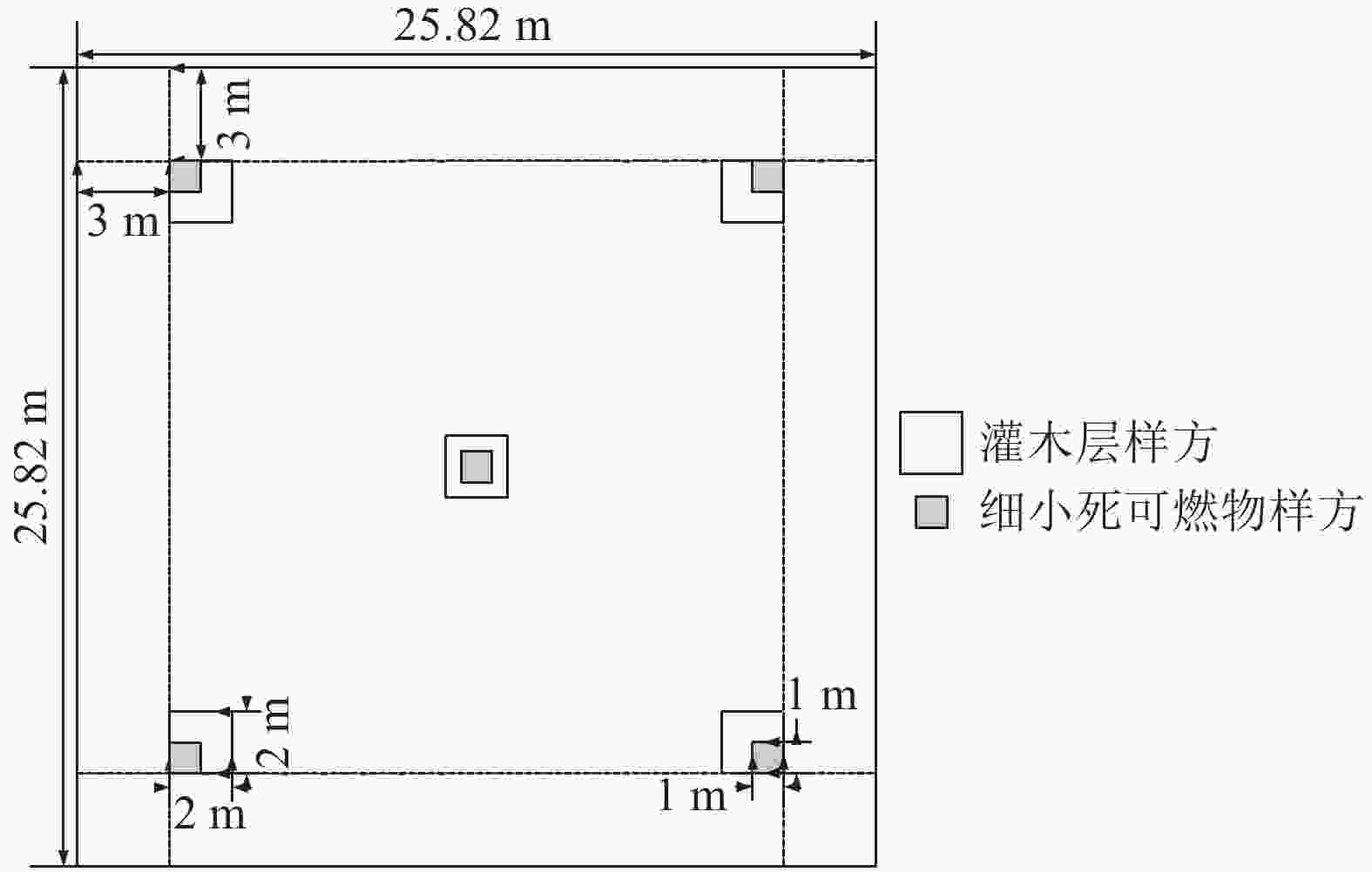
      Figure 1.  Sample quadrat setting method

      式(1)中:$ {W}_{n} $为1个样地中n个小样方凋落物1和凋落物2样品总鲜质量(g);P为干鲜比(%); S为样方面积(m²)。

    • 随机森林模型最早是由BREIMAN[14]提出的一种基于决策树的机器学习算法,在处理多重共线性变量或非平衡数据时能够得到精度较高的预测结果[15],不仅可以用于聚类和判别分析,还可以用来进行回归分析以探究影响因子的重要性。该模型利用Bootstrap重抽样技术,从原始样本集T中重复随机抽取N个样本(一般为总样本量的2/3),并生成新的训练样本集,剩下未被抽取的数据作为随机森林模型的验证样本集,产生一系列具有差异性的决策树模型,通过使用投票或者取平均值的组合策略得到随机森林。

      为保证建立的模型性能优良,模型对于地表细小死可燃物载量估算的适应程度高,需要开展模型参数调整工作。对于随机森林模型来说,森林中决策树的数量(n)和每次随机抽取的变量个数(m)是非常重要的2个参数。本研究将数据集按照7∶3的比例分为训练集和测试集,即利用120个样方数据组成样本数据集对模型进行建模,使用52个样方数据组成测试数据集评估拟合精度,评估过程与训练过程同时进行。为了探索nm对训练过程的影响,以有序递增的方式将n的取值范围设置在1 000以内,并将m的取值范围限定为2~5。

      本研究采用ArcGIS Pro 3.0.1软件中的“基于森林的分类与回归”模块,进行随机森林模型的训练和估算。在随机森林模型中,估算因子的重要性通过均方误差增加百分比[16]衡量。该方法对每个估算因子随机赋值,如果该估算因子更为重要,被随机替换后模型预测的误差会更大,变量具有更高的预测能力。

    • 本研究从地形因子、林分因子、植被类型因子和光谱特征指数因子中筛选随机森林模型的估算因子。为了消除多重线性,提高模型效率,采用SPSS 22进行Pearson相关性分析,对地形因子、林分因子、植被类型因子和光谱特征指数因子进行筛选[17]。由于Pearson相关系数适用于度量连续型变量的相关程度,因此对起源、龄组、坡位、坡向和植被类型等因子按照表1所示属性进行赋值。

      起源龄组坡向坡位植被类型
      属性属性属性属性属性
      天然林1幼龄林,幼龄竹11脊背1暖性针叶林1
      人工林2中龄林2东北2上坡2落叶阔叶林2
      近熟林,壮龄竹33中坡3常绿阔叶林3
      成熟林,过熟林4东南4下坡4常绿、落叶阔叶混交林4
      老龄竹5山谷5竹林5
      西南6
      西7
      西北8
      无坡9
        说明:植被类型参考《中国植被》分类系统进行分类。

      Table 1.  Partial sample site survey factor assignment

      本研究认定因子间相关系数绝对值>0.4,且P<0.01为强相关,由此剔除部分因子,其余因子间相关系数绝对值≤0.4或P≥0.01,说明独立性较强[17]。依据以上原则,在林分因子中选择起源、龄组、林分密度和平均胸径作为估算因子;在地形因子中选择坡位、坡度作为估算因子;在植被类型因子中选择植被类型作为估算因子;在光谱特征指数因子中选择热度指数(LST)、水分胁迫指数(MSI)、归一化植被指数(NDVI)和增强型植被指数(EVI)作为估算因子,估算安化县地表细小死可燃物载量。Pearson相关性分析结果如图2所示。

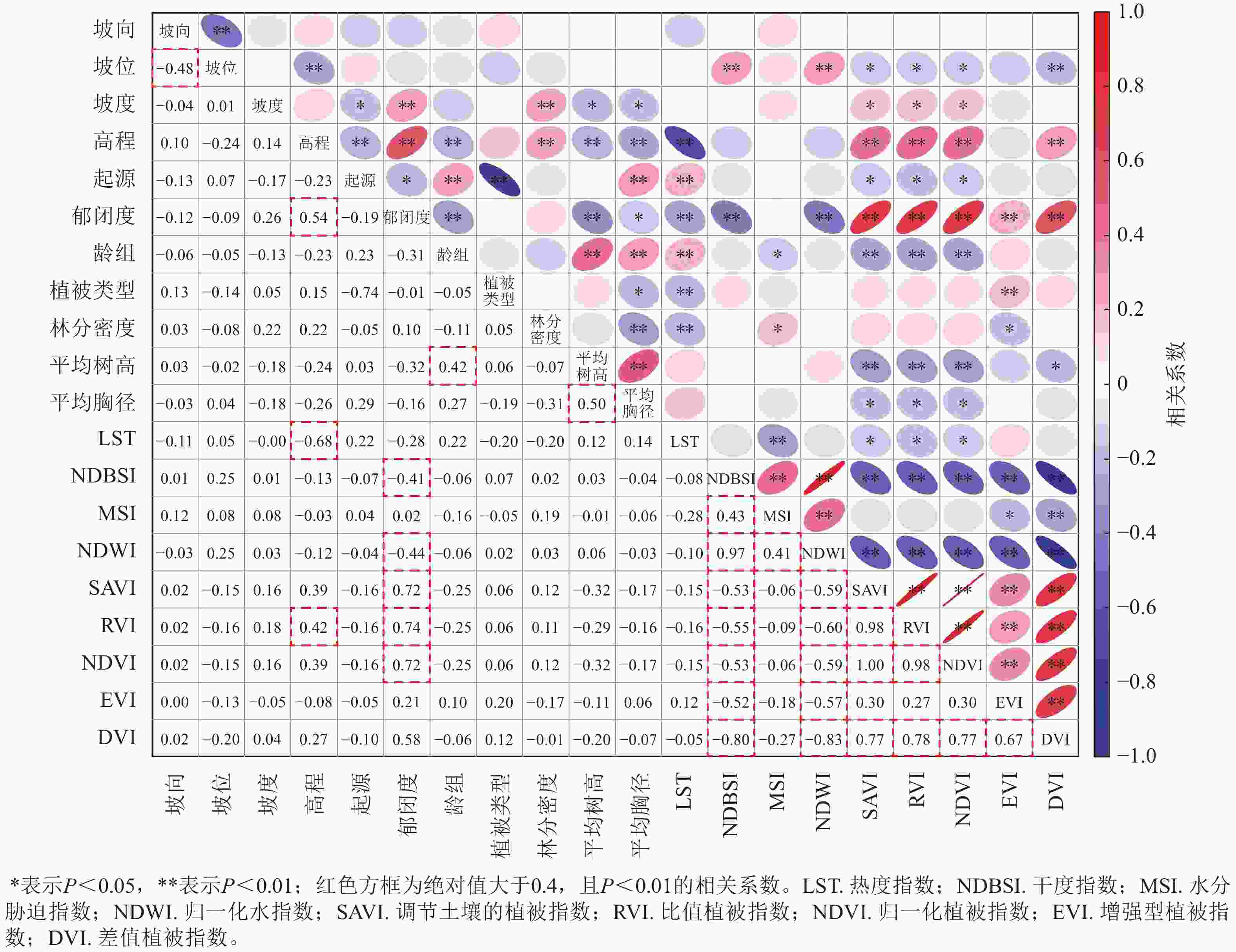
      Figure 2.  Pearson correlation analysis results

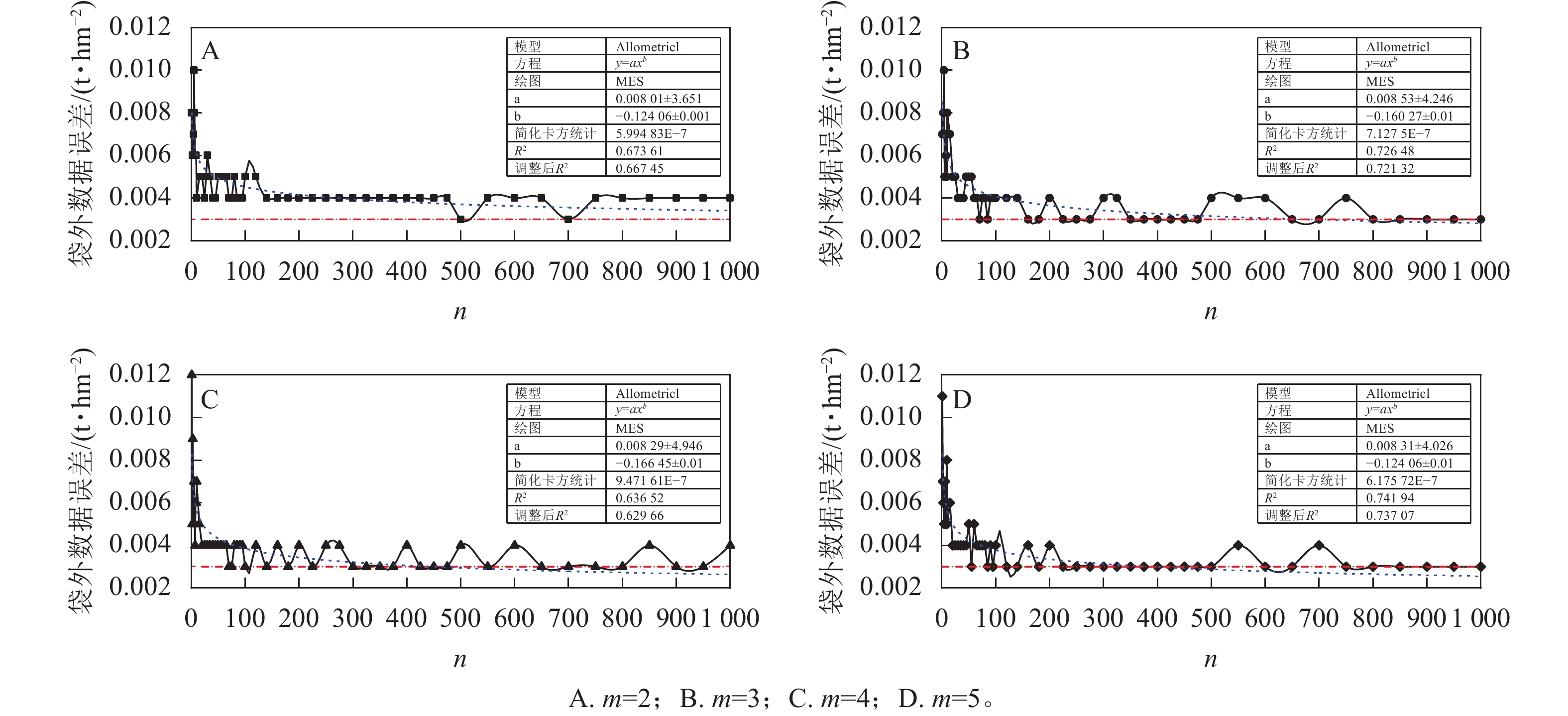
    • 图3为随机森林算法的n与袋外数据(OOB)误差的关系。经过对多种回归模型进行评估后,选择幂函数模型拟合其变化趋势。可以看出m的取值影响随机森林的收敛速度以及稳定程度,直接影响了模型的训练质量。当m取值为2时(图3A),OOB误差在n为180时接近收敛,稳定在接近0.004 t·hm−2的水平;当m取值为3或4时(图3BC),OOB误差在快速收敛后,在0.003~0.004 t·hm−2处于一定程度的震动;当m取值为5时(图3D),OOB误差在n为220时接近收敛,稳定在接近0.003 t·hm−2的水平。一味地增加决策树的数量并不能使预测最优,应该结合OOB误差变化趋势及其波动情况,综合考虑模型的复杂程度。为了保证预测结果的可靠性,本研究最终确定将nm的值分别设置为400和5。

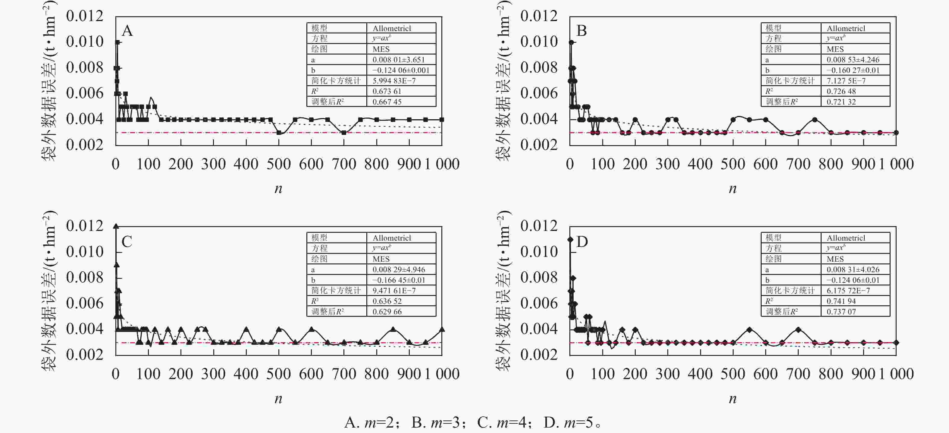
      Figure 3.  Out of Bag (OOB) error curves of the Random Forest Model

    • 利用得到的参数设置模型,对训练集进行判定,并对测试集进行预测,结果如表2所示。在训练集上, 决定系数(R2)为0.930,置信度超过0.01水平,均方根误差为0.262 3 t·hm−2;在测试集上,R2为0.724,置信度超过0.01水平,均方根误差为0.416 6 t·hm−2。结果表明:随机森林模型在地表细小死可燃物载量估算方面具有较好的性能,抗过拟合能力强,也说明随机森林模型的有效性。综上所述,随机森林模型可较好地应用于地表细小死可燃物载量估算。

      性能度量指标 R2 P 均方根误差/(t·hm−2)
      训练集 0.930 <0.01 0.262 3
      测试集 0.724 <0.01 0.416 6

      Table 2.  Accuracy statistics of the Random Forest Model

    • 本研究采用均方误差增加百分比(%)对森林地表细小死可燃物载量估算因子重要性进行评价。结果表明:植被类型是影响安化县地表细小死可燃物载量估算的最重要因子,其均方误差增加百分比为39.95%,其次为平均胸径、龄组、起源,其重要性得分分别为10.33%、7.20%、7.09%;光谱特征指数因子[热度指数(4.31%)、归一化植被指数(4.28%)、水分胁迫指数(3.38%)和增强型植被指数(3.29%)]、地形因子[坡位(4.60%)、坡度 (3.21%)和林分密度(4.29%)]的均方误差增加百分比较小,均小于5.00%。地表细小死可燃物载量各估算因子按类型分组的重要性指数平均值从大到小依次为植被类型因子(39.95%)、林分因子(7.23%)、地形因子(3.91%)、光谱特征指数因子(3.82%)。

    • 利用得到的参数确定最佳模型的均方根误差和决定系数对安化县地表细小死可燃物载量进行估算和绘制(图4)。由图4可知:安化县地表细小死可燃物载量为1.18~6.19 t·hm−2,集中于4.00~5.00 t·hm−2,其面积占比为66.33%;地表细小死可燃物载量为5.00~6.19 t·hm−2的区域面积占比14.21%;地表细小死可燃物载量为1.18~2.00 t·hm−2的区域面积占比12.53%。地表细小死可燃物载量高于5.00 t·hm−2的区域主要分布在江南镇、田庄乡、马路镇、烟溪镇、乐安镇、梅城镇和滔溪镇;地表细小死可燃物载量低于2.00 t·hm−2的区域主要分布在羊角塘镇、小淹镇、滔溪镇、长塘镇和大福镇。

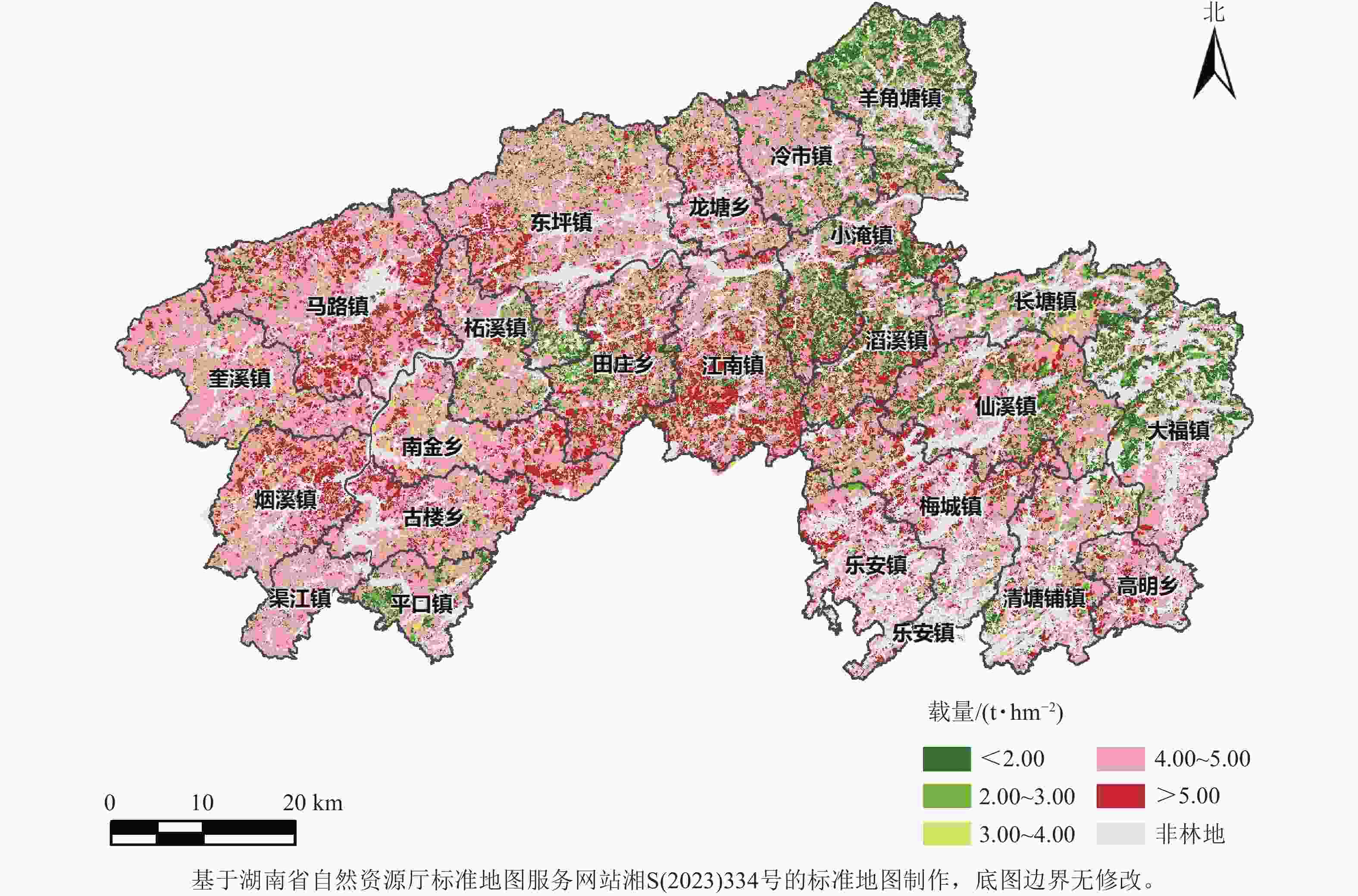
      Figure 4.  Spatial distribution of the predicted fine dead fuel loads in Anhua County using the Random Forest Model

    • 本研究采用Sentinel-2A卫星遥感数据提取的光谱特征指数,野外样地调查得到的林分因子、植被类型和地形地貌等多个因子,探讨了随机森林模型对地表细小死可燃物载量估算的能力。通过Pearson相关性分析对这些因子进行筛选,以减少数据维度和存储空间,提高估算速度,增强模型的可解释性和性能[18]

      从模型性能指标可以看出:随机森林模型对地表细小死可燃物载量的估算表现出出色的性能, 在训练集和验证集上,决定系数分别为0.930和0.724,均方根误差分别为0.262 3和0.416 6 t·hm−2,均通过了0.01水平的置信度检验。LI等[10]通过随机森林模型估算不同类别森林的地上生物量,并对预测值和观测值进行线性回归分析,结果显示:决定系数为0.630~0.690,均方根误差为21.940 0~24.580 0 t·hm−2。HE等[19]综合考虑地形、物种多样性、林分结构和林分密度等多个变量,通过随机森林模型估算森林生物量,得到决定系数最高中值为0.790,最低均方误差中值为1.365 8 t·hm−2。丁志丹等[20]使用随机森林模型分别估算杉木林和马尾松林的地上生物量,结果显示:决定系数分别为0.6500.720,均方根误差分别为48.160048.1800 t·hm−2

      本研究中各估算因子在随机森林模型中的重要性存在显著差异,植被类型因子表现出远高于其他因子的估算能力。本研究的结果揭示了在随机森林算法中使用的解释因素重要性的巨大差异。植被类型的预测能力显著高于其他因子,其均方误差增加百分比为39.95%,高于平均胸径的10.33%。不同的植被类型导致细小死可燃物的树叶与树枝比例、化学成分和物质类型等存在差异,而植被的生长速度和生理特征的差异也导致细小死可燃物的积累速度不同。如刘讯等[6]研究发现:大娄山不同林型地表细小死可燃物载量中,马尾松和阔叶混交林显著高于其他林分,除杉木林和灌木林外,其他林分的地表细小死可燃物载量与林分因子显著关联。

      估算中采用的林分因子包括龄组、林分密度、起源和平均胸径等,这些因子直接影响地表细小死可燃物的数量和分布,在估算地表细小死可燃物载量的过程中起着相当重要的作用[21]。马云辉等[22]研究发现:在蒙古栎Quercus mongolica次生林中,1 h时滞细小可燃物载量会随着冠层密度、林分密度、龄组的增加而显著增加。孙武等[23]研究表明:各类天然林,如马尾松林、刨花润楠Machilus pauhoi林、丝栗栲Castanopsis rargesn林等的地表可燃物载量较大,火险隐患较高;木荷Schima superba、桤木Alnus cremastogyne、柏木Cupressus funebris和水杉Metasequoia glyptostroboides等人工林可燃物载量小,火险隐患较低。

      地形因子(坡度和坡位)在地表细小死可燃物载量估算过程中起到了相对较小的重要性。这一发现与D’ESTE等[24]的研究结果相符合。已有研究表明:地形因子对林火的发生、蔓延和扩散具有重要影响。例如,ELIA等[25]研究发现:海拔和坡度显著影响意大利山火发生的概率。此外,AJIN等[26]在印度喀拉拉邦的研究发现:不同土地覆盖类型对森林火灾的发生具有显著影响,而地形因子的影响较小。与此同时,尚无证据表明地形因子会影响地表细小死可燃物载量的积累过程。

      光谱特征指数因子不提供植被结构信息[27],而是定性描述植物的光学性质,如叶绿素和反射率[28]。此外,当面对树冠层密集,结构复杂且存在多层次空间异质性的植被时,遥感信号响应机制不清晰[29],光谱特征指数无法反映林下覆盖状况。

      从本研究结果可以看出:安化县地表细小死可燃物呈现出明显聚集的分布特点,这是因为随着植被类型空间分异和林分结构的复杂性变化,地表细小死可燃物载量也会变化,从而影响森林火灾风险。

      当前,随机森林模型表现出相对可靠的性能,但依然存在一定的提升空间。如激光雷达在估算地表细小死可燃物方面拥有极高的性能[30],但雷达数据覆盖面较小,且成本高。同时需要进一步探讨估算因子对细小死可燃物载量空间分布的影响,如与气候或景观异质性相关的变量[31]

    • 随机森林模型对地表细小死可燃物载量的估算表现出出色的性能,可用于定期估计地表细小死可燃物载量;估算过程中各因子的重要性存在显著差异,其中植被类型因子表现出远高于其他因子的估算能力,其后分别为林分因子、地形因子和光谱特征指数因子。

Reference (31)

Catalog

    /

    DownLoad:  Full-Size Img  PowerPoint
    Return
    Return