Volume 38 Issue 1
Jan.  2021
Turn off MathJax
Article Contents

CAO Jiashuo, DENG Zhengyu, HU Yuandong, WU Yan. Spatial and temporal evolution and driving forces of the landscape pattern in Shennongjia Forestry District[J]. Journal of Zhejiang A&F University, 2021, 38(1): 155-164. doi: 10.11833/j.issn.2095-0756.20200279
Citation: CAO Jiashuo, DENG Zhengyu, HU Yuandong, WU Yan. Spatial and temporal evolution and driving forces of the landscape pattern in Shennongjia Forestry District[J]. Journal of Zhejiang A&F University, 2021, 38(1): 155-164. doi: 10.11833/j.issn.2095-0756.20200279

Spatial and temporal evolution and driving forces of the landscape pattern in Shennongjia Forestry District

doi: 10.11833/j.issn.2095-0756.20200279
  • Received Date: 2020-04-16
  • Rev Recd Date: 2020-11-04
  • Available Online: 2021-01-21
  • Publish Date: 2021-01-21
  •   Objective  With a quantitative analysis conducted of the changes in the landscape pattern in Shennongjia Forestry District due to the implementation of forest protection projects since 1990s as well as their driving mechanisms, this study is aimed to explore the effectiveness of the conservation in this region and provide a reference for the future ecological environment protection and rational land use.  Method  Supported by remote sensing (RS) and geographic information system (GIS) technology and taking Shennongjia Forestry District as the research object, with remote sensing images from three different periods of 1996, 2007 and 2018 selected as data sources, this paper has mainly employed land use transfer matrix, landscape pattern distribution center of gravity model and landscape pattern index.  Result  Between 1996 and 2018, the landscape of forest land and water areas has retained a stable and favorable state while there is a general decrease in the area of grassland and cultivated land showed; There has been a more significant tendency in the conversion of other land types to construction land and such changes mainly attribute to human factors.  Conclusion  Ecological protection and restoration projects such as returning farmland to forests in Shennongjia Forestry District have been rewarded with a better integrated landscape pattern, enhanced landscape diversity in spite of aggravated local fragmentation as well as more favorable socioeconomic and ecological space. On the other hand, due attention should be paid to threats against ecological security induced by the booming local tourism with various natural landscapes replaced by artificial patches. [Ch, 4 fig. 5 tab. 32 ref.]
  • [1] WANG Xiangfu, LI Yuanhui, WANG Weifeng, SUN Jiejie, WANG Qian, DONG Wenting, WANG Rongnü, YANG Yaqi.  Impact of land use and climate change on potential suitable habitats of snow leopards (Panthera uncia) in Qinghai Province . Journal of Zhejiang A&F University, 2024, 41(3): 1-9. doi: 10.11833/j.issn.2095-0756.20230259
    [2] ZUO Qilin, YU Yang, ZHA Tonggang, ZHANG Hengshuo, LIANG Yipeng, OUYANG Jiahuan.  Soil quality assessment of different land use types in Qingshui River Basin of western Shanxi Province . Journal of Zhejiang A&F University, 2023, 40(4): 801-810. doi: 10.11833/j.issn.2095-0756.20220498
    [3] PAN Ting, WANG Yixiang, LIU Xianzhao, XU Chengli, LIU Zhijun.  Land use change and its impact on ecological quality in Xiong’an New Area . Journal of Zhejiang A&F University, 2023, 40(5): 1102-1110. doi: 10.11833/j.issn.2095-0756.20220596
    [4] LI Jiahao, LIU Yuguo, ZHAO Ziqing, ZHOU Yining, XU Zihan, CHEN Xinjun, CUI Ming.  Temporal and spatial dynamic monitoring of land desertification and landscape pattern evolution characteristics in the Xiaoluan River Basin . Journal of Zhejiang A&F University, 2023, 40(6): 1322-1332. doi: 10.11833/j.issn.2095-0756.20220731
    [5] CHEN Xi, YE Kemo, LI Kun, JIN Yang.  Research on land use change and risk-value of “production-living-ecological space” in a resource-based city . Journal of Zhejiang A&F University, 2023, 40(5): 1111-1120. doi: 10.11833/j.issn.2095-0756.20220666
    [6] WU Genghong, WANG Yiru, LIU Tiedong, GONG Wenfeng, LIN Shiping, CHEN Chong.  Evaluation of landscape pattern evolution and spatial configuration of urban park green space in Haikou City based on SEDMs model . Journal of Zhejiang A&F University, 2023, 40(5): 1093-1101. doi: 10.11833/j.issn.2095-0756.20220702
    [7] YANG Dongwei, ZHANG Jianqiang, HUANG Xuebin, ZHANG Mingkui.  Spatiotemporal differentiation of organic carbon in upland soils converted from paddy field under the leisure agriculture tourism background in Zhejiang Province . Journal of Zhejiang A&F University, 2022, 39(6): 1296-1302. doi: 10.11833/j.issn.2095-0756.20210607
    [8] JIA Yujie, LIU Yungen, YANG Silin, WANG Yan, ZHANG Chao, XU Hongfeng, ZHENG Shujun.  Applicability of land use classification method in Dali City based on Sentinel-2A image . Journal of Zhejiang A&F University, 2022, 39(6): 1350-1358. doi: 10.11833/j.issn.2095-0756.20220134
    [9] LI Wenhao, SHEN Jun.  Spatio-temporal variation of farmland fragmentation in water net plain area . Journal of Zhejiang A&F University, 2021, 38(4): 723-729. doi: 10.11833/j.issn.2095-0756.20200682
    [10] CUI Yanglin, GAO Xiang, DONG Bin, WEI Huimin.  Landscape ecological risk assessment of county . Journal of Zhejiang A&F University, 2021, 38(3): 541-551. doi: 10.11833/j.issn.2095-0756.20200461
    [11] YU Fei, LI Zhiyong.  Forests landscape pattern changes and driving forces in Mount Tianmu . Journal of Zhejiang A&F University, 2020, 37(3): 439-446. doi: 10.11833/j.issn.2095-0756.20190306
    [12] SUN Min, CHEN Jian, LIN Xintao, YANG Shan.  Urban landscape patterns and PM2.5 pollution . Journal of Zhejiang A&F University, 2018, 35(1): 135-144. doi: 10.11833/j.issn.2095-0756.2018.01.018
    [13] DUAN Yanbo, LEI Yakai, MA Ge, WU Baojun, TIAN Guohang.  Spatio-temporal dynamics of ecosystem service value in Zhengzhou . Journal of Zhejiang A&F University, 2017, 34(3): 511-519. doi: 10.11833/j.issn.2095-0756.2017.03.017
    [14] LI Xianping, FENG Zhongke, YOU Xianxiang, QU Shuai.  Remote sensing dynamic monitoring and driving force analysis of county-cities expansion . Journal of Zhejiang A&F University, 2016, 33(5): 798-806. doi: 10.11833/j.issn.2095-0756.2016.05.011
    [15] YU Jing-fang, YU Shu-quan, ZHANG Chao, LI Tu-sheng.  Net primary productivity estimates for Zhejiang Province based on the CASA model . Journal of Zhejiang A&F University, 2012, 29(4): 473-481. doi: 10.11833/j.issn.2095-0756.2012.04.001
    [16] WU Jian, PENG Dao-li.  Technology of land use remote sensing information extraction in Duolun County . Journal of Zhejiang A&F University, 2010, 27(3): 417-423. doi: 10.11833/j.issn.2095-0756.2010.03.016
    [17] HUI Shu-rong, WANG Jiao, ZHANG Qian, WEI Zhong-ping, LIU Yang.  Soil-water dynamics with different agroforestry planting combinations on sandy lands in northwestern Liaoning Province . Journal of Zhejiang A&F University, 2010, 27(4): 579-584. doi: 10.11833/j.issn.2095-0756.2010.04.017
    [18] GU Lei, WU Chun-jun, WANG Xin.  Land utilization pattern changing and driving force analysis based on remote sensing data in Lin’an . Journal of Zhejiang A&F University, 2009, 26(6): 870-876.
    [19] CAO Yin-gui, ZHOU Wei, CHENG Ye, XU Ning, HAO Yin.  A review of land use and land cover changes in China . Journal of Zhejiang A&F University, 2007, 24(5): 633-637.
    [20] JIANG Wen-wei, GUAN Yu, LIU Tong, ZHOU Guo-mo, SHEN Zhen-ming.  Forecast of land use pattern change in Anji County of Zhejiang : an application of Markov process . Journal of Zhejiang A&F University, 2004, 21(3): 309-312.
  • [2]
    ZHANG Qiuju, FU Bojie, CHEN Liding. Several problems about landscape pattern change research [J]. Sci Geogr Sin, 2003, 23(3): 264 − 270.
    [3]
    LÜ Leting, ZHANG Jie, PENG Qiuzhi, et al. Landscape pattern analysis and prediction in the Dongjiang River Basin [J]. Acta Ecol Sin, 2019, 39(18): 6850 − 6859.
    [4]
    FU Bojie, ZHANG Liwei. Land-use change and ecosystem services: concepts, methods and progress [J]. Prog Geogr, 2014, 33(4): 441 − 446.
    [5]
    JIANG Guanghui, ZHANG Fengrong, KONG Xiangbin, et al. The spatial differentiation of construction land expansion in Beijing mountainous area [J]. Geogr Res, 2006, 25(5): 905 − 912.
    [6]
    YU Hong, ZENG Hui, JIANG Ziying. Study on distribution characteristics of landscape elements along the terrain gradient [J]. Sci Geogr Sin, 2001, 21(1): 64 − 69.
    [7]
    GONG Yingbi. The Spatial-Temporal Pattern Evolution of Wetland Landscape and Its Driving Mechanism in Changsha[D]. Changsha: Central South University of Forestry and Technology, 2013.
    [8]
    HOU Xinyuan. Growth Response of Abies fargesii at Different Altitudes in Shennongjia Nature Reserve of Hubei Province, Southeastern China[D]. Nanjing: Nanjing University, 2015.
    [9]
    YUAN Qin. The Exploition of Shennongjia Forest Region-Based on History Perspective[D]. Yangling: Northwest A&F University, 2015.
    [10]
    WANG Zhengxiang, ZHU Junlin, WAN Jing, et al. Preliminary study on hydrologic characteristics of main rivers in Shennongjia Forest Region [J]. J Hubei Univ Nat Sci, 2013, 35(1): 6 − 10.
    [11]
    LI Chengyue. The Design and Implementation of the Ecological Carrying Capacity Assessment System based on the Cloud Platform[D]. Wuhan: Wuhan University, 2017.
    [12]
    PENG Jian, WANG Yanglin, WU Jiansheng, et al. Evaluation for regional ecosystem health: methodology and research progress [J]. Acta Ecol Sin, 2007, 27(11): 4877 − 4885.
    [13]
    BAI Genchuan, XIA Jianguo, WANG Changquan, et al. Land use transition in Dongpo District, Meishan City in China based on a tendentious model for analyzing spatial transition of land use types [J]. Resour Sci, 2009, 31(10): 1793 − 1799.
    [14]
    WANG Qi, MENG Jijun, MAO Xiyan. Scenario simulation and landscape pattern assessment of land use change based on neighborhood analysis and auto-logistic model: a case study of Lijiang River Basin [J]. Geogr Res, 2014, 33(6): 1073 − 1084.
    [15]
    HAN Huiran, YANG Chengfeng, SONG Jinping. The spatial-temporal characteristic of land use change in Beijing and its driving mechanism [J]. Econ Geogr, 2015, 35(5): 148 − 154.
    [16]
    XIE Xia, WANG Hongwei, Tashpolat Tiyip. Study on landscape pattern change in Ebinur Lake region based on RS and GIS [J]. J Desert Res, 2010, 30(5): 1166 − 1173.
    [17]
    WEI Jing, ZHENG Xiaogang, GE Jingfeng. Spatial and temporal change of landscape pattern in the western Shijiazhuang, Taihang Mountains [J]. Acta Ecol Sin, 2007, 27(5): 1993 − 2001.
    [18]
    LIU Xinliang, LI Yong, SHEN Jianlin, et al. Landscape pattern changes at a catchment scale: a case study in the upper Jinjing river catchment in subtropical central China from 1933 to 2005 [J]. Landscape Ecol Eng, 2014, 10(2): 263 − 276.
    [19]
    AHLQVIST O, SHORTRIDGE A. Spatial and semantic dimensions of landscape heterogeneity [J]. Landscape Ecol, 2010, 25(4): 573 − 590.
    [20]
    CEN Xiaoteng. Correlation Analysis and Optimization between Land Use Landscape Patterns and Ecosystem Service Values-a Case Study of South Coast of Hangzhou Bay[D]. Hangzhou: Zhejiang University, 2016.
    [21]
    XU Shuang, LI Feixue, ZHANG Luben, et al. Spatiotemporal changes of thermal environment landscape pattern in Changsha [J]. Acta Ecol Sin, 2015, 35(11): 3743 − 3754.
    [22]
    XU Beishen. Study on Landscape Pattern Evolution of Land Use and Ecological Security Assessment in Jianghan Plain[D]. Wuhan: Central China Normal University, 2012.
    [23]
    ZHU Huiyi, LI Xiubin, HE Shujin, et al. Spatio-temporal change of land use in Bohai Rim [J]. Acta Geogr Sin, 2001, 68(3): 253 − 260.
    [24]
    GUO Hui, WANG Bing, NIU Xiang. Construction method of ecological benefits monitoring network of China Grain for Green Project [J]. Bull Soil Water Conserv, 2014, 34(6): 131 − 133.
    [25]
    LI Boshan. Study of Influence on Water Ecoenvironment and Ecosystem Health Assessment for Water Resources Development and Utilization in Hanjiang River Basin[D]. Wuhan: Wuhan University, 2013.
    [26]
    YU Jing, WANG Xuelei, WU Yijin, et al. Changes of Shennongjia Dajiuhu landscape pattern and the strategies of wetland ecological restoration [J]. J Huazhong Agric Univ, 2008, 25(1): 122 − 126.
    [27]
    CHEN Lu, WANG Zhengxiang, LEI Yun, et al. The characteristic of climate change in Shennongjia forest area from 1990 to 2010 [J]. J Hubei Univ Nat Sci, 2013, 35(1): 11 − 16.
    [28]
    HUANG Jing, XIA Zhihong. Research on the change characteristics for Shennongjia forest vegetation index based on MODIS-EVI Data [J]. Meteorol Environ Sci, 2013, 36(3): 39 − 43.
    [29]
    LIU Jiayan, XIE Zongqiang, SHEN Guozhen, et al. Dynamics and analysis of vegetation fraction changes in Shennongjia Forest District during 1998 to 2013 by using SPOT-VEGETATION NDVI data [J]. Acta Geogr Sin, 2018, 38(11): 3961 − 3969.
    [30]
    ZHANG Ziyi, ZHA Yuping, WANG Shaoming, et al. Bionomics of Dendroctonus armandi in Shennongjia Forestry District [J]. For Pest Dis, 2015, 34(6): 1 − 4.
    [31]
    YU Fei, LI Zhiyong. Forests landscape pattern changes and driving forces in Mount Tianmu [J]. J Zhejiang A&F Univ, 2020, 37(3): 439 − 446.
    [32]
    RUSHDI A M A, HASSAN A K. Reliability of migration between habitat patches with heterogeneous ecological corridors [J]. Ecol Mod, 2015, 304: 1 − 10.
  • 加载中
通讯作者: 陈斌, bchen63@163.com
  • 1. 

    沈阳化工大学材料科学与工程学院 沈阳 110142

  1. 本站搜索
  2. 百度学术搜索
  3. 万方数据库搜索
  4. CNKI搜索

Figures(4)  / Tables(5)

Article views(1441) PDF downloads(52) Cited by()

Related
Proportional views

Spatial and temporal evolution and driving forces of the landscape pattern in Shennongjia Forestry District

doi: 10.11833/j.issn.2095-0756.20200279

Abstract:   Objective  With a quantitative analysis conducted of the changes in the landscape pattern in Shennongjia Forestry District due to the implementation of forest protection projects since 1990s as well as their driving mechanisms, this study is aimed to explore the effectiveness of the conservation in this region and provide a reference for the future ecological environment protection and rational land use.  Method  Supported by remote sensing (RS) and geographic information system (GIS) technology and taking Shennongjia Forestry District as the research object, with remote sensing images from three different periods of 1996, 2007 and 2018 selected as data sources, this paper has mainly employed land use transfer matrix, landscape pattern distribution center of gravity model and landscape pattern index.  Result  Between 1996 and 2018, the landscape of forest land and water areas has retained a stable and favorable state while there is a general decrease in the area of grassland and cultivated land showed; There has been a more significant tendency in the conversion of other land types to construction land and such changes mainly attribute to human factors.  Conclusion  Ecological protection and restoration projects such as returning farmland to forests in Shennongjia Forestry District have been rewarded with a better integrated landscape pattern, enhanced landscape diversity in spite of aggravated local fragmentation as well as more favorable socioeconomic and ecological space. On the other hand, due attention should be paid to threats against ecological security induced by the booming local tourism with various natural landscapes replaced by artificial patches. [Ch, 4 fig. 5 tab. 32 ref.]

CAO Jiashuo, DENG Zhengyu, HU Yuandong, WU Yan. Spatial and temporal evolution and driving forces of the landscape pattern in Shennongjia Forestry District[J]. Journal of Zhejiang A&F University, 2021, 38(1): 155-164. doi: 10.11833/j.issn.2095-0756.20200279
Citation: CAO Jiashuo, DENG Zhengyu, HU Yuandong, WU Yan. Spatial and temporal evolution and driving forces of the landscape pattern in Shennongjia Forestry District[J]. Journal of Zhejiang A&F University, 2021, 38(1): 155-164. doi: 10.11833/j.issn.2095-0756.20200279
  • 景观格局反映景观要素在空间结构上的特征,可以从不同尺度讨论要素间的相互作用与生态效应[1],是景观异质性的外在表征。目前,国内外学者对于景观格局的研究主要分为2个方面,即景观格局的空间质异性与时间异质性研究[2]。景观异质性在空间上的表达往往是复杂而连续的,因此以遥感(RS)和地理信息系统(GIS)等方法结合景观格局指数进行讨论,有助于实现格局演变的可视化。在景观生态学中,认为土地即景观[1]。据以往研究来看,土地利用变化可以反映景观格局演变过程,将土地利用同生态环境与自然资源系统相结合进行探讨,成为国内外研究的热点问题[3-4]。伴随3S技术的快速发展,土地利用的空间分异研究取得了长足的进展,土地利用结构分析已应用到城市及山区用地空间扩展[5]、景观组分在地形梯度上的分异[6]、湿地格局分异[7]等诸多方面。神农架林区位于中国地势二、三阶梯过渡地带,是中国重要的气候敏感区和生态环境脆弱地带[8]。20世纪六七十年代间,由于不合理开发导致区域生态环境遭严重破坏,林区政府开始探索绿色可持续发展模式[9]。本研究将基于多源数据,对神农架林区土地利用结构的组成及其时空演变特征与驱动力进行探讨,以探究20世纪90年代以来森林保护工程的成效,同时为林区的生态系统健康评价研究提供参考。

  • 神农架林区地处鄂西北山区,是中国唯一以“林区”命名的行政区划,总面积约3 215.80 km2。林区地处31°15′~31°57′N,109°56′~110°58′E,西南部以近东西向的山脉为主,其中最高峰神农顶高3 105.4 m,是华中地区最高点[10]。神农架林区是中国东西植物区系的交汇地带和南北植物区系的过渡地带,其亚热带森林生态系统是全球中纬度地区唯一保存完好的地区,拥有世界上最为丰富的生物多样性[11],是具有全球意义的基因库,被称为“绿色奇迹”,林区内包括森林、灌丛、草甸和湿地等各类生态系统,具有调节气候、涵养水源、保持水土等重要生态环境服务价值[12]。近年来,以旅游业为主体的第三产业发展迅速,2018年全区旅游收入达57.29亿元,林区内建设用地规模大幅扩张,生态风险有所升高。

  • 以1996、2007、2018年Landsat遥感影像为数据基础,影像空间分辨率为30 m,选取每个年份植被状态良好的2景影像,影像的云量均低于2%;相关规划资料详见表1

    数据类型数据名称来源
    遥感影像  1996年125/38、126/38 Landsat 5 TM遥感影像美国地质勘探局网站(http://glovis.usgs.gov/)
    2007年125/38、126/38 Landsat 8 OLI遥感影像
    2018年125/38、126/38 Landsat 8 OLI遥感影像
    相关规划资料《神农架林区土地利用总体规划(2006−2020年)》中国神农架林区人民政府
    《神农架林区国民经济和社会发展统计公报》
    《神农架林区统计年鉴》中国神农架林区统计局
    《神农架国家公园体制试点建设白皮书》中国神农架国家公园管理局

    Table 1.  Data source statistics

    在ENVI 5.3.1软件中对遥感影像进行预处理,通过对遥感影像的目视判读和对研究区域的实地调查,采用最大似然法对遥感影像进行监督分类。根据研究目的,结合国家标准GB/T 21010−2017《土地利用现状分类》,将神农架林区土地划分为林地、草地、建设用地、耕地和水域等五大类。利用Erdas Imagine 2015软件计算解译精度,结果显示3个年份Kappa系数都达85%以上,符合研究需要。

  • 土地利用转移矩阵用于描述不同土地利用类型之间的转移情况,能反映研究时间段内土地利用类型转移的数量与方向[13-15]。其通用公式为

    式(1)中:Aij为土地面积;n为土地利用类型数;ij为转移前后的土地利用类型。

  • 景观格局分布的重心模型用于研究景观格局在空间上的分布情况,而多年份数据的叠加则可以反映景观格局重心在不同时刻的迁移变化,是过程研究中重要的表征指标[16-17]

    重心坐标计算公式为:

    重心距离迁移公式为:

    式(2)~(4)中:XtYt为研究区域内某一景观类型在时间t的重心坐标;Dtit时刻研究区域内第i个斑块的面积;XiYi表示研究区域的坐标;D为某一景观类型的重心在t1t2时间段内移动的距离。

  • 景观格局指数是描述景观变化的一种定量研究方法,是景观格局结构组成与空间配置信息的集中反映[18-20]。选取8个对于景观结构变化较为敏感的指数:斑块数(NP)、最大斑块指数(LPI)、散布与并列指数(IJI)、聚合度指数(AI)、分离度指数(SPLIT)、景观分割指数(DIVISION)、内聚力指数(COHESION)与香农多样性指数(SHDI),采用移动窗口法[21-22],在Fragstats软件中每次移动1个栅格,以900 m大小的移动窗口,计算得到研究区域各指数的空间分布,分析神农架林区景观格局破碎化及多样性特征。

  • 图1表2可以看出:林地是研究区域最主要的用地类型,占林区总面积的90%以上,22 a间,林地面积累计增加39.34 km2,森林覆盖度呈现增长趋势;草地与耕地面积总体上呈现减少趋势;建设用地面积持续增加,近10 a间增速比较明显,2018年研究区域内建设用地面积与1996年相比增加43.55 km2,这与该地区城镇化建设和旅游的大力发展有关;水域面积累计增加6.75 km2

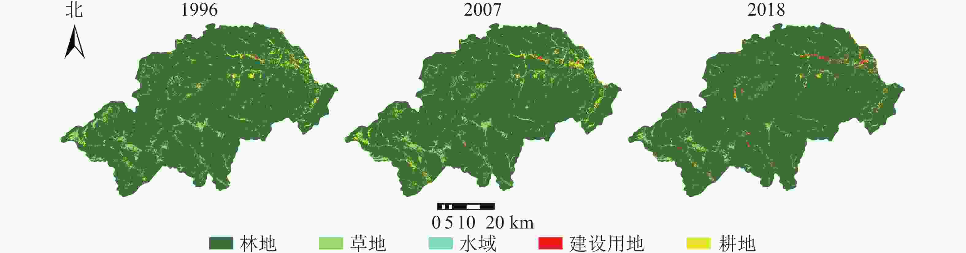
    Figure 1.  Land cover types in Shennongjia Forestry District basin in 1996, 2007, 2018

    年份林地草地建设用地耕地水域
    面积/km2比例/%面积/km2比例/%面积/km2比例/%面积/km2比例/%面积/km2比例/%
    19963 006.8092.9594.862.93 3.490.11129.824.01 2.390.07
    20072 994.1192.7883.722.59 8.060.25141.254.3810.210.32
    20183 046.1494.0959.081.8247.051.45 75.962.35 9.130.28

    Table 2.  Land use structure in Shennongjia Forestry District basin in 1996, 2007, 2018

  • 表3可知:1996−2007年,林地转移为其他类型景观的面积变化量最大,主要转移为耕地和草地,转出面积分别为49.29和23.47 km2,而转移为林地最多的景观类型也是耕地和草地,由此可知林地与耕地、草地间相互转移关系密切,90%以上的新增建设用地由林地和耕地转化而来。

    年份土地利用类型2007
    林地/km2草地/km2建设用地/km2耕地/km2水域/km2
    1996林地  2 925.3023.472.8349.295.91
    草地  33.5054.880.286.170.04
    建设用地0.070.062.040.590.72
    耕地  35.065.322.8585.111.48
    水域  0.180.010.060.092.05
    年份土地利用类型2018
    林地/km2草地/km2建设用地/km2耕地/km2水域/km2
    2007林地  2 949.679.4015.3117.382.36
    草地  36.9242.990.932.400.47
    建设用地0.880.065.741.150.23
    耕地  56.616.6022.1654.781.09
    水域  2.050.012.910.264.98
    年份土地利用类型2018
    林地/km2草地/km2建设用地/km2耕地/km2水域/km2
    1996林地  2 935.2114.3525.4526.355.43
    草地  48.1041.391.603.330.45
    建设用地0.160.032.740.260.30
    耕地  62.473.3116.8845.941.22
    水域  0.200.010.380.061.73

    Table 3.  Land use transfer matrix in Shennongjia Forestry District of 1996−2007, 2007−2018 and 1996−2018

    2007−2018年,林地仍然是转移面积最大的景观类型,主要转移为耕地和建设用地,转移面积分别为17.38和15.31 km2,表明神农架林区在城镇化建设及旅游业发展过程中,仍存在以占用林地作为代价进行开发建设的现象;林地与耕地、草地间仍保持着密切的相互转移关系,而林地的转出面积减少37.05 km2,转入面积增加27.66 km2,林地的总面积增加趋势显著。

  • 通过ArcGIS计算,得到1996、2007和2018年神农架林区各个用地类型景观格局分布重心转移的距离、速度和方向(表4)。1996−2018年,研究区域内水域和建设用地重心迁移明显,水域重心在研究时段内持续向西南方向迁移,累计迁移11 745.64 m,其中,1996−2007年迁移速度较快,为829.11 m·a−1,主要是由于大九湖湿地恢复与水库修建导致的;建设用地重心向西南方向迁移10 752.54 m,说明神农架林区的建设向西南发展,尤其是2016年进入国家公园发展的新时代,其范围划定也与建设用地重心的迁移方向相印证;林地具有向东扩张趋势,其重心在研究时间内向东南方向移动5 594.52 m。

    景观类型1996−20072007−20181996−2018
    距离/m速度/(m·a−1)方向距离/m速度/(m·a−1)方向距离/m速度/(m·a−1)方向
    林地  5 674.80515.89东南2 895.32263.21东北5 594.52254.30东南
    草地  3 088.72280.79东南7 127.86647.99西南5 286.79240.31西南
    建设用地9 120.18829.11西南2 926.19266.02西北10 752.54488.75西南
    耕地  6 124.45556.77西南5 135.85466.90东北1 441.9465.54东北
    水域  891.6281.06西南2 331.64211.97西南11 745.64533.89西南

    Table 4.  Landscape type transfer direction and distance

  • 从同年份的同类型景观比较结果(表5)来看:林地斑块个数最少,最大斑块指数与内聚力指数均较高,景观分割指数小于0.2,说明林地斑块的完整性较好,景观破碎化程度低,林地为研究区域的景观基质,而建设用地和水域等类型则以斑块或廊道的形式镶嵌其中。

    年份景观类型NPLPIIJICOHESIONDIVISIONSPLITAI
    1996林地  37292.7552.1499.990.141.1698.67
    草地  2 2280.2726.2796.231.0037 674.5885.72
    建设用地2740.0264.5186.601.0011 459 303.8272.60
    耕地  4 6180.1325.9092.271.00134 702.2778.60
    水域  1880.0363.5490.101.009 165 348.7872.24
    2007林地  40489.4759.1499.990.201.2598.63
    草地  2 4700.3534.0296.061.0035 191.2785.05
    建设用地6100.0479.7285.511.004 732 108.8871.91
    耕地  4 7320.1340.0793.861.0085 981.1277.94
    水域  1 0130.0570.2888.061.002 654 644.9564.97
    2018林地  29293.9885.8999.990.121.1398.84
    草地  1 9230.1429.4294.541.00112 169.2783.75
    建设用地3 1680.1166.8188.651.00522 690.5570.45
    耕地  4 1920.0452.1787.891.00719 999.0472.54
    水域  9890.0470.5188.751.002 563 736.6667.51

    Table 5.  Change of landscape pattern index from 1996 to 2018

    从不同年份的同类型景观比较结果(表5)来看:林地的景观破碎化程度先增后减,草地、耕地与水域的景观破碎化程度与分散程度在研究时段内呈增加趋势;人类活动使建设用地不断增加并向外扩张,使其破碎化程度在总体上呈上升趋势,但随着城镇化的推进,建设用地景观类型内部也出现了一定程度的整合。

    图2可见:从整体上看,神农架林区景观的破碎度有所降低,趋于整合;从局部来看,东北部区域与中南部区域的破碎化程度加剧,建设用地等人工斑块的扩张导致部分区域景观破碎度升高,而景观多样性也随之呈现扩散趋势;而林区多年来封山育林、人工造林、退耕还林等保护工作的开展,使得部分重点保护区域内林地面积持续增加,在地表覆被类型中占据主导地位,因此这些区域内景观多样性会呈现一定的降低趋势。

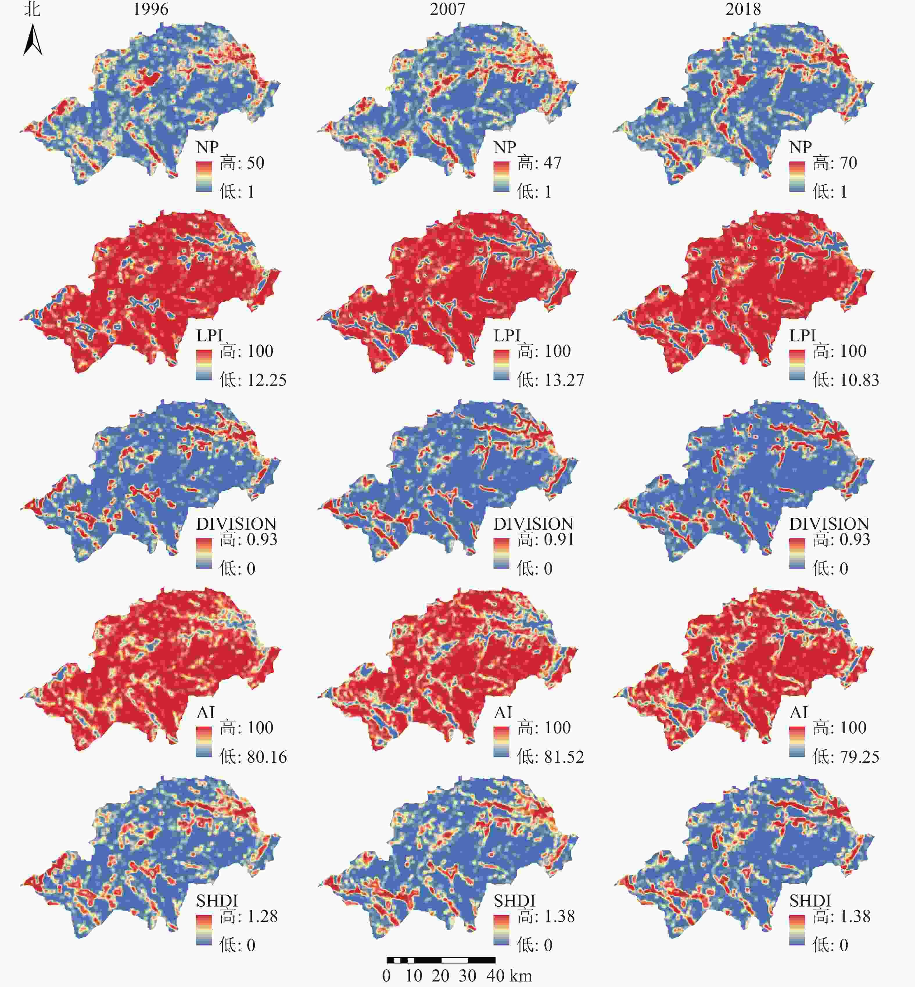
    Figure 2.  Landscape fragmentation and diversity index of Shennongjia Forestry District from 1996 to 2018

  • 通过对神农架林区1996−2018年经济发展数据(图3)与景观格局演变特征的分析对比,可知在开发历史较久,受经济增长与人类活动干扰较大的地区,景观格局演变较为显著,如东北部的松柏镇是神农架林区政府的驻地所在,而中南部的木鱼镇是神农架自然保护区管理局的驻地,也是神农架旅游接待服务中心,这些区域的景观破碎化程度呈现出较为明显的升高趋势。近年来旅游业更是逐步成为神农架林区的支柱性产业,2018年林区的旅游总收入接近57.3亿元,约为地区生产总值的2倍。与此同时林区大力开展的旅游配套设施建设及房地产项目开发,使得人工斑块数量显著增加。22 a间林区建设用地面积骤增43.56 km2,所占比例由0.11%提升至1.45%。因此,经济因素对神农架林区景观格局的演变具有重要影响。

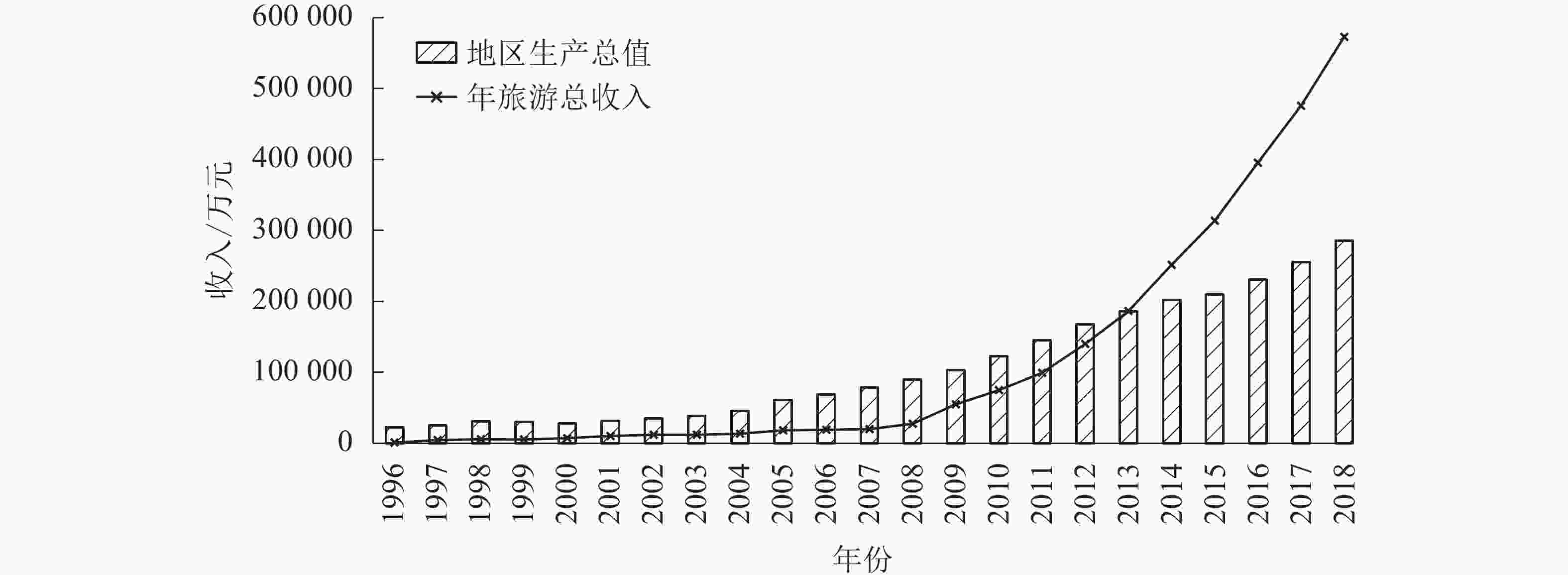
    Figure 3.  Trend of GDP and total tourism revenue change in Shennongjia Forestry District from 1996 to 2018

  • 图4可见:神农架林区人口数量出现先增后减的趋势;神农坛、天生桥、官门山、大九湖在内的几大主要景区游客接待量逐年上涨,于2018年突破1 587.5万人次。为提高游客接待能力而进行的景区开发,使得区域景观类型发生显著变化,1996−2018年,林地累计向建设用地转移25.45 km2,局部空间与生态环境所承受的压力随之增大。林区于2014年开展“美丽乡村”建设,以村庄布局“减量、聚居”为总体要求,注重农村土地资源综合整治,因此耕地及建设用地中的住宅用地分布有所整合,但旅游服务用地的增加仍然造成了景观破碎化程度的升高。

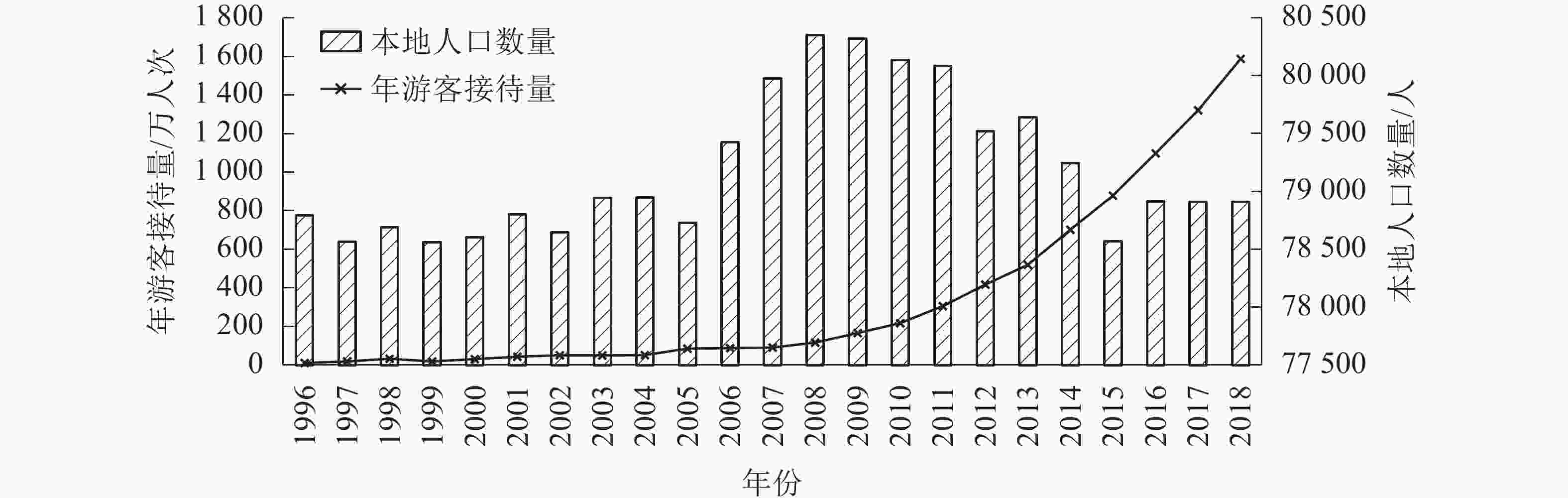
    Figure 4.  Local population and annual tourist reception change in Shennongjia Forestry District from 1996 to 2018

  • 土地利用结构及变化深受区域政策影响[23]。20世纪60−80年代,采取毁林开荒的开发方式追求经济效益,神农架林区的生态环境遭到严重破坏,森林覆盖率骤降至63.5%。神农架林区于2000年全面启动天然林资源保护工程和退耕还林还草工程[24],研究时段内耕地向林地、草地转移面积超过65 km2;2003年确立“保护第一,科学规划,合理开发,永续利用”的发展方针,促进生态环境逐步改善,森林覆盖率达90%以上;2011年发布《神农架旅游总体规划》,加快推进神农顶、官门山和天生桥景区配套设施建设,区域内建设用地面积显著增长,同时也与建设用地重心向西南迁移相印证;2016年7月,神农架被正式列入世界自然遗产名录,同年11月,神农架国家公园管理局正式成立,标志着神农架的保护与管理工作步入国家公园新时代[9]。1996−2018年,林区内水域面积累计增加6.75 km2,其中湿地的生态恢复成果得益于大九湖国家湿地公园的建立,湿地科学监测与保护工作在政策的引导下逐渐步入正轨[25-26]

  • 相比于社会经济因素,自然因子的作用在短时间内并非十分显著,但从长远时间看,气候等因子的变化将对区域景观格局产生重大影响。1996−2018年,神农架林区的林地面积显著增加,林地主要由耕地和草地转化而来,除去政策的引导作用,主要依靠自然更新因素完成转化。近年来,神农架林区年降水量及年平均气温均呈较为微弱的增加趋势[27],小气候条件优越,加之林区内土壤有机质含量丰富,为耕地向林地的演替提供了有利条件。

  • 1996−2018年,神农架林区森林覆盖度总体上呈增长趋势,这与前人研究的结果一致[28]。刘家琰等[29]利用SPOT-VEGETATION数据对林区1998−2013年植被覆盖度格局变化进行分析,发现植被覆盖度呈较好增长趋势,整体变化率为1.45%。水域景观面积显著增加,破碎度升高,湿地生态恢复稳中向好,这主要得益于湿地生态保护政策的有效实施,人为因素在过程中起到了决定性作用[24],在保护优先的政策指导下,林区逐步走上良性循环的绿色发展道路。同时,也有学者对自然因素进行探究,张子一等[30]讨论了个别年份受极端气候与虫害等自然因素,导致常绿植物受灾使其覆盖度有所下降。

    城镇化的持续推进与旅游产业的迅速发展,造成了人工斑块对林地、草地等自然景观类型的侵占,景区内旅游基础设施的兴建,对生态环境造成严重的干扰,增大生态压力。建设用地的扩张促使区域内景观破碎度与多样性的增加,生态空间与社会经济空间融合程度不断加深。

    由于旅游业的发展需求,连通林区内外的交通建设逐年推进。截至2018年林区内公路里程数达2 048.5 km,其中各大景区范围内公路网建设较为密集,造成林区景观局部破碎化[31],导致原本连续的生态廊道网络出现生态间隙[32],阻碍生态流的正常流动,降低了生物迁移的安全性。神农架机场位于林区中西部的红坪镇,于2014年正式通航,机场的落成使得区域内建设用地与耕地面积骤增,分割并部分取代了原有大面积草地斑块,强烈的人工干扰可能会降低区域生态系统的稳定性。

  • 1996−2018年,神农架林区土地利用结构变化显著,森林覆盖度总体上呈现增长趋势,湿地生态恢复稳中向好。随着神农架林区对于生态发展政策方针的不断调整与优化,森林保护工程成效日益显现,同时也在逐渐改变生态系统的结构和功能。

    景观破碎度在整个研究区域内呈现降低趋势,表明神农架林区景观总体上趋于整合,但局部破碎化程度加剧,林区东北部与中南部区域地表覆被逐渐由原本较为整合的林地景观转变为多种用地类型共存,林区建设用地的持续扩张,社会经济空间与生态空间相互融合。人为因素是引起景观格局变化的主导因素,近年来神农架大力开发的旅游产业造成了人工斑块对自然景观的侵占,其他用地类型向建设用地转化的趋势较明显,将对生态系统安全产生威胁。

Reference (32)

Catalog

    /

    DownLoad:  Full-Size Img  PowerPoint
    Return
    Return