Volume 40 Issue 2
Apr.  2023
Turn off MathJax
Article Contents

LI Siyuan, YE Zhenni, MAO Yongwei, CHEN Yuling, ZENG Na. Comparison of four fusion models for generating high spatio-temporal resolution NDVI[J]. Journal of Zhejiang A&F University, 2023, 40(2): 427-435. doi: 10.11833/j.issn.2095-0756.20220381
Citation: LI Siyuan, YE Zhenni, MAO Yongwei, CHEN Yuling, ZENG Na. Comparison of four fusion models for generating high spatio-temporal resolution NDVI[J]. Journal of Zhejiang A&F University, 2023, 40(2): 427-435. doi: 10.11833/j.issn.2095-0756.20220381

Comparison of four fusion models for generating high spatio-temporal resolution NDVI

doi: 10.11833/j.issn.2095-0756.20220381
  • Received Date: 2022-07-31
  • Accepted Date: 2022-11-24
  • Rev Recd Date: 2022-11-24
  • Publish Date: 2023-04-20
  •   Objective  In order to choose adapted fusion methods in vegetation survey and dynamic monitoring, we applied four different spatio-temporal fusion models including spatial and temporal adaptive reflectance fusion model (STARFM), enhanced spatial and temporal adaptive reflectance fusion model (ESTARFM), regression model fitting, spatial filtering and residual compensation (Fit-FC) and the rule-based piecewise regression tree model (RPRTM).   Method  Based on the four spatio-temporal fusion models (STARFM, ESTARFM, Fit-FC and RPRTM), two sampling regions (region Ⅰ and Ⅱ), with different surfaces characteristics in the Three-River Headwaters Regions were taken to generate the high spatial information of the Landsat NDVI (30 m, 16 d). Based on Landsat NDVI image, the spatial characteristics of the fusion data of different fusion models were evaluated by qualitative visual discrimination and quantitative statistical analysis. Meanwhile, based on the MODIS NDVI time series, the fitting effect of different fusion methods on the dynamic characteristics of surface vegetation was analyzed.   Result  (1) RPRTM had the optimal spatial fusion performance in region Ⅰ (R2=0.82); and ESTARFM performed the best in region Ⅱ (R2=0.95). (2) RPRTM has achieved the best fusion for capturing temporal dynamics (R2=0.97−0.99), where the NDVI dynamics were highly consistent with the temporal variations of MODIS. (3) Compared with the spatio-temporal comparability of model input data, landscape heterogeneity had a greater impact on the fusion effect of STARFM and ESTARFM.   Conclusion  Spatio-temporal fusion models can be used effectively to generate NDVI data at high spatial and temporal resolution, with different models having different fusion effects. RPRTM performing well in both complex surface areas and simulated vegetation growth dynamics. [Ch, 4 fig. 1 tab. 38 ref.]
  • [1] CAI Mengqing, HUANG Lu, YAN Lijiao.  Temporal and spatial variation characteristics of annual water yield and its influencing factors in Hangzhou based on InVEST model . Journal of Zhejiang A&F University, 2022, 39(1): 127-135. doi: 10.11833/j.issn.2095-0756.20210170
    [2] FEI Ximin, SHEN Yueqin, ZHAO Fuming.  Impact of farmers’ bamboo industry integration participation and human capital on their income . Journal of Zhejiang A&F University, 2021, 38(6): 1261-1269. doi: 10.11833/j.issn.2095-0756.20210363
    [3] SHEN Jiapeng, CHEN Dongsheng, SUN Xiaomei, ZHANG Shougong.  Modeling a single-tree biomass equation by seemingly unrelated regression and dummy variables with Larix kaempferi . Journal of Zhejiang A&F University, 2019, 36(5): 877-885. doi: 10.11833/j.issn.2095-0756.2019.05.005
    [4] MU Yanan, DING Lixia, LI Nan, LU Linying, WU Ming.  Classification of coastal wetland vegetation in Hangzhou Bay with an object-oriented, random forest model . Journal of Zhejiang A&F University, 2018, 35(6): 1088-1097. doi: 10.11833/j.issn.2095-0756.2018.06.012
    [5] ZHANG Heng, SUN Zijian, ZHANG Yunlin, JIN Sen, WANG Yuxia.  Distance of meteorological data from test site and fine fule forecast model accuracy . Journal of Zhejiang A&F University, 2018, 35(3): 529-536. doi: 10.11833/j.issn.2095-0756.2018.03.019
    [6] YANG Shuisheng, XU Xiuying, FU Jiaoyan, XU Jinhan.  Research on bamboo production efficiency based on three-stage DEA model . Journal of Zhejiang A&F University, 2017, 34(6): 1128-1136. doi: 10.11833/j.issn.2095-0756.2017.06.022
    [7] HU Man, PENG Daoli.  Comparison of fusion algorithms for GF-2 data from extracted forestland information . Journal of Zhejiang A&F University, 2017, 34(2): 340-348. doi: 10.11833/j.issn.2095-0756.2017.02.019
    [8] BAI Xuebing, XU Jingtao, GUO Jingqiu, CHEN Kai.  Segmentation of wood surface knots and wormholes based on an improved LBF Model . Journal of Zhejiang A&F University, 2016, 33(2): 306-314. doi: 10.11833/j.issn.2095-0756.2016.02.017
    [9] WANG Lin, JING Yuanshu, ZHANG Yue.  Spatio-temporal variation for vegetative NPP in the lower-middle reaches of the Yangtze River based on MODIS data . Journal of Zhejiang A&F University, 2015, 32(6): 829-836. doi: 10.11833/j.issn.2095-0756.2015.06.002
    [10] LI Yadan, DU Huaqiang, ZHOU Guomo, GU Chengyan, XU Xiaojun, SUN Shaobo, GAO Guolong.  Chlorophyll content in Phyllostachys violascens related to hyper-spectral vegetation indices and development of an inversion model . Journal of Zhejiang A&F University, 2015, 32(3): 335-345. doi: 10.11833/j.issn.2095-0756.2015.03.002
    [11] WEI Xiao-hui, SUN Yu-jun, MA Wei.  A height growth model for Cunninghamia lanceolata based on Richards’ equation . Journal of Zhejiang A&F University, 2012, 29(5): 661-666. doi: 10.11833/j.issn.2095-0756.2012.05.004
    [12] WANG Xiao-ning, XU Tian-shu, LI Yi.  Estimating forest volume in hilly regions with the ALOS PALSAR model’s dual polarization data . Journal of Zhejiang A&F University, 2012, 29(5): 667-670. doi: 10.11833/j.issn.2095-0756.2012.05.005
    [13] HUANG Chu-dong, SHAO Yun, LI Jing, LIU Jing-hui, CHEN Jie-qiong.  Urban forest research based on regression tree techniques and ASTER imagery . Journal of Zhejiang A&F University, 2008, 25(2): 240-244.
    [14] LOU Xiong-wei, FANG Lu-ming, XU Ai-jun, YE Xiang-gen.  Data fusion with 3D modeling for forest fire prevention background database . Journal of Zhejiang A&F University, 2008, 25(4): 405-410.
    [15] JIANG Wen-Wei, GUAN Yu, WANG Zu-liang, PAN Jun-hui.  Application of remnant GM (1 , 1) to prediction of content of sulfur dioxide in atmosphere . Journal of Zhejiang A&F University, 2002, 19(2): 178-181.
    [16] GAO Feng.  Adaptive prediction control of complex system model and its simulation . Journal of Zhejiang A&F University, 2001, 18(4): 433-437.
    [17] XIANG Xiao-qiang, WANG Jin-zhi, ZHA Yin-shui, LI Yue-qing.  Phase-varied growth model technique and its applications in subcompartment data updating . Journal of Zhejiang A&F University, 1999, 16(3): 279-282.
    [18] Lu Xiaozhen, Ye Jingzhong, Sun Duo.  Application of the linear autoregression model with input variables to forecast tree phenology. . Journal of Zhejiang A&F University, 1998, 15(2): 201-206.
    [19] Ge Hongli, Xiang Xiaoqiang, He Shizhen, Gu Jinrong.  Variances Estimation of A Sequence Forecasted by An Autoregression Model . Journal of Zhejiang A&F University, 1997, 14(4): 382-387.
    [20] Xie Zhegen, Tang Zhengliang, Weng Weisong, Dai Junqiang, WangHongxi.  Study on Merchant Volume Ratio prediction Model Systems. . Journal of Zhejiang A&F University, 1996, 13(4): 392-396.
  • [1]
    YANG Jun. Study of Extracting the Forest Area Based on the ETM+ Remote Sensing Image [D]. Nanjing: Nanjing Agricultural University, 2006.
    [2]
    BARET F, GUYOT G, MAJOR D. TSAVI: a vegetation index which minimizes soil brightness effects on LAI and APAR estimation [C]// International Geoscience and Remote Sensing Symposium. 12th Canadian Symposium on Remote Sensing Geoscience and Remote Sensing Symposium. Vancouver: Institute of Electrical and Electronics Engineers, 1989: 1355 − 1358.
    [3]
    GEERKEN R, ZAITCHIK B, EVANS J P. Classifying rangeland vegetation type and coverage from NDVI time series using Fourier Filtered Cycle Similarity [J]. International Journal of Remote Sensing, 2005, 26(24): 5535 − 5554.
    [4]
    WARDLOW B D, EGBERT S L, KASTENS J H. Analysis of time-series MODIS 250 m vegetation index data for crop classification in the U. S. Central Great Plains [J]. Remote Sensing of Environment, 2007, 108(3): 290 − 310.
    [5]
    MASELLI F, CHIESI M. Integration of multisource NDVI data for the estimation of Mediterranean forest productivity [J]. International Journal of Remote Sensing, 2006, 27(1): 55 − 72.
    [6]
    PARUELO J M, EPSTEIN H E, LAUENROTH W K, et al. ANPP estimates from NDVI for the central grassland region of the United States [J]. Ecology, 1997, 78(3): 953 − 958.
    [7]
    ULLAH S, SI Yali, SCHLERF M, et al. Estimation of grassland biomass and nitrogen using MERIS data [J]. International Journal of Applied Earth Observation and Geoinformation, 2012, 19: 196 − 204.
    [8]
    LI Xiaosong, LI Zengyuan, GAO Zhihai, et al. Estimation of vegetation cover in desertified regions from Hyperion imageries using NDVI and partial least squares regression [J]. Journal of Desert Research, 2011, 31(1): 162 − 167.
    [9]
    LIU Guangfeng, WU Bo, FAN Wenyi, et al. Extraction of vegetation coverage in desertification regions based on the dimidiate pixel model: a case study in Maowusu Sandland [J]. Research of Soil and Water Conservation, 2007, 14(2): 268 − 271.
    [10]
    HILKER T, WULDER M A, COOPS N C, et al. Generation of dense time series synthetic Landsat data through data blending with MODIS using a spatial and temporal adaptive reflectance fusion model [J]. Remote Sensing of Environment, 2009, 113(9): 1988 − 1999.
    [11]
    CONGALTON R, ODERWALD R G, MEAD R. Assessing Landsat classification accuracy using discrete multivariate analysis statistical techniques [J]. Photogrammetric Engineering and Remote Sensing, 1983, 49(12): 1671 − 1678.
    [12]
    YUAN Fei, SAWAYA K E, LOEFFELHOLZ B C, et al. Land cover classification and change analysis of the Twin Cities (Minnesota) Metropolitan Area by multitemporal Landsat remote sensing [J]. Remote Sensing of Environment, 2005, 98(2): 317 − 328.
    [13]
    DUBE T, MUTANGA O. Evaluating the utility of the medium-spatial resolution Landsat 8 multispectral sensor in quantifying aboveground biomass in uMgeni catchment South Africa [J]. ISPRS Journal of Photogrammetry and Remote Sensing, 2015, 101: 36 − 46.
    [14]
    SCHMIDT T, FORSTERET M, GÄRTNER P, et al. Prediction of NDVI for grassland habitats by fusing RapidEye and Landsat imagery [C]// Geoscience and Remote Sensing Society. 2015 8th International Workshop on the Analysis of Multitemporal Remote Sensing Images (Multi-Temp). Annecy: Institute of Electrical and Electronics Engineers, 2015: 1 − 4.
    [15]
    EMELYANOVA I V, MCVICAR T R, van NIEL T G, et al. Assessing the accuracy of blending Landsat-MODIS surface reflectances in two landscapes with contrasting spatial and temporal dynamics: a framework for algorithm selection [J]. Remote Sensing of Environment, 2013, 133(suppl C): 193 − 209.
    [16]
    REEVES M C, ZHAO Maosheng, RUNNING S W. Applying improved estimates of MODIS productivity to characterize grassland vegetation dynamics [J]. Rangeland Ecology &Management, 2006, 59(1): 1 − 10.
    [17]
    GAO Tian, XU Bin, YANG Xiuchun, et al. Using MODIS time series data to estimate aboveground biomass and its spatio-temporal variation in Inner Mongolia’s grassland between 2001 and 2011 [J]. International Journal of Remote Sensing, 2013, 34(21): 7796 − 7810.
    [18]
    GU Yingxin, WYLIE B K, BLISS N B. Mapping grassland productivity with 250 m eMODIS NDVI and SSURGO database over the Greater Platte River Basin, USA [J]. Ecological Indicators, 2013, 24(1): 31 − 36.
    [19]
    LI Fei, JIANG Lei, WANG Xufeng, et al. Estimating grassland aboveground biomass using multitemporal MODIS data in the West Songnen Plain, China [J/OL]. Journal of Applied Remote Sensing, 2013, 7(1): 073546[2022-06-01]. doi: 10.1117/1.JRS.7.073546.
    [20]
    JIN Yuanxiang, YANG Xiuchun, QIU Jianjun, et al. Remote sensing-based biomass estimation and its spatio-temporal variations in temperate grassland, northern China [J]. Remote Sensing, 2014, 6(2): 1496 − 1513.
    [21]
    BOYTE S P, WYLIE B K, RIGGE M B, et al. Fusing MODIS with Landsat 8 data to downscale weekly normalized difference vegetation index estimates for central Great Basin rangelands, USA [J]. GIScience &Remote Sensing, 2017, 55(3): 376 − 399.
    [22]
    GAO Feng, MASEK J, SCHWALLER M, et al. On the blending of the Landsat and MODIS surface reflectance: predicting daily Landsat surface reflectance [J]. IEEE Transactions on Geoscience and Remote Sensing, 2006, 44(8): 2207 − 2218.
    [23]
    SHI Yuechan, YANG Guijun, LI Xinchuan, et al. Intercomparison of the different fusion methods for generating high spatial-temporal resolution data [J]. Journal of Infrared and Millimeter Waves, 2015, 34(1): 92 − 99.
    [24]
    HOBYB A, RADGUI A, TAMTAOUI A, et al. Evaluation of spatiotemporal fusion methods for high resolution daily NDVI prediction [C]//GERAID S. 2016 5th International Conference on Multimedia Computing and Systems. Marrakech: Institute of Electrical and Electronics Engineers, 2016: 121 − 126.
    [25]
    ZHOU Junxiong, CHEN Jin, CHEN Xuehong, et al. Sensitivity of six typical spatiotemporal fusion methods to different influential factors: a comparative study for a normalized difference vegetation index time series reconstruction [J]. Remote Sensing of Environment, 2021, 252: 112 − 130.
    [26]
    WANG Qunming, ATKINSON P M. Spatio-temporal fusion for daily Sentinel-2 images [J]. Remote Sensing of Environment, 2018, 204: 31 − 42.
    [27]
    JIANG Chong, ZHANG Linbo. Climate change and its impact on the eco-environment of the Three-Rivers Headwater Region on the Tibetan Plateau, China [J]. International Journal of Environmental Research and Public Health, 2015, 12(10): 12057 − 12081.
    [28]
    ZENG Na, REN Xiaoli, HE Hongli, et al. Estimating the grassland aboveground biomass in the Three-River Headwater Region of China using machine learning and Bayesian model averaging [J/OL]. Environmental Research Letters, 2021, 16: 114020[2022-06-01]. doi: 10.1088/1748-9326/ac2e85.
    [29]
    ZENG Na, REN Xiaoli, HE Honglin, et al. Aboveground biomass of grasslands in the Three-River Headwaters Region based on neural network [J]. Environmental Research Letters, 2017, 30(1): 59 − 66.
    [30]
    YI Xiangsheng, YIN Yanyu, LI Guosheng, et al. Temperature variation in recent 50 years in the Three-River Headwaters Region of Qinghai Province [J]. Acta Geographica Sinica, 2011, 66(11): 1451 − 1465.
    [31]
    LIU Jiyuan, XU Xinliang, SHAO Quanqin. Grassland degradation in the “Three-River Headwaters” region, Qinghai Province [J]. Acta Geographica Sinica, 2008, 18(4): 364 − 376.
    [32]
    WU Bingfang, YUAN Quanzhi, YAN Changzhen, et al. Land cover changes of China from 2000 to 2010 [J]. Quaternary Sciences, 2014, 34(4): 723 − 731.
    [33]
    ZHU Xiaolin, CHEN Jin, GAO Feng, et al. An enhanced spatial and temporal adaptive reflectance fusion model for complex heterogeneous regions [J]. Remote Sensing of Environment, 2010, 114(11): 2610 − 2623.
    [34]
    GU Yingxin, WYLIE B K. Downscaling 250 m MODIS growing season NDVI based on multiple-date Landsat images and data mining approaches [J]. Remote Sensing, 2015, 7(4): 3489 − 3506.
    [35]
    LIU Maolin, KE Yinghai, YIN Qi, et al. Comparison of five spatio-temporal satellite image fusion models over landscapes with various spatial heterogeneity and temporal variation [J/OL]. Remote Sensing, 2019, 11(22): 2612[2022-06-01]. doi: 10.3390/rs11222612.
    [36]
    ZHANG Xiaoli, LI Xiongfei, LI Jun. Validation and correlation analysis of metrics for evaluating performance of image fusion [J]. Acta Automatica Sinica, 2014, 40(2): 306 − 315.
    [37]
    ZHANG Binghua, ZHANG Li, XIE Dong, et al. Application of synthetic NDVI time series blended from Landsat and MODIS data for grassland biomass estimation [J/OL]. Remote Sensing, 2016, 8(1): 10[2022-06-01]. doi: 10.3390/rs8010010.
    [38]
    LI Aihua, BO Yanchen, ZHU Yuxin, et al. Blending multi-resolution satellite sea surface temperature (SST) products using Bayesian maximum entropy method [J]. Remote Sensing of Environment, 2013, 135: 52 − 63.
  • 加载中
通讯作者: 陈斌, bchen63@163.com
  • 1. 

    沈阳化工大学材料科学与工程学院 沈阳 110142

  1. 本站搜索
  2. 百度学术搜索
  3. 万方数据库搜索
  4. CNKI搜索

Figures(4)  / Tables(1)

Article views(361) PDF downloads(31) Cited by()

Related
Proportional views

Comparison of four fusion models for generating high spatio-temporal resolution NDVI

doi: 10.11833/j.issn.2095-0756.20220381

Abstract:   Objective  In order to choose adapted fusion methods in vegetation survey and dynamic monitoring, we applied four different spatio-temporal fusion models including spatial and temporal adaptive reflectance fusion model (STARFM), enhanced spatial and temporal adaptive reflectance fusion model (ESTARFM), regression model fitting, spatial filtering and residual compensation (Fit-FC) and the rule-based piecewise regression tree model (RPRTM).   Method  Based on the four spatio-temporal fusion models (STARFM, ESTARFM, Fit-FC and RPRTM), two sampling regions (region Ⅰ and Ⅱ), with different surfaces characteristics in the Three-River Headwaters Regions were taken to generate the high spatial information of the Landsat NDVI (30 m, 16 d). Based on Landsat NDVI image, the spatial characteristics of the fusion data of different fusion models were evaluated by qualitative visual discrimination and quantitative statistical analysis. Meanwhile, based on the MODIS NDVI time series, the fitting effect of different fusion methods on the dynamic characteristics of surface vegetation was analyzed.   Result  (1) RPRTM had the optimal spatial fusion performance in region Ⅰ (R2=0.82); and ESTARFM performed the best in region Ⅱ (R2=0.95). (2) RPRTM has achieved the best fusion for capturing temporal dynamics (R2=0.97−0.99), where the NDVI dynamics were highly consistent with the temporal variations of MODIS. (3) Compared with the spatio-temporal comparability of model input data, landscape heterogeneity had a greater impact on the fusion effect of STARFM and ESTARFM.   Conclusion  Spatio-temporal fusion models can be used effectively to generate NDVI data at high spatial and temporal resolution, with different models having different fusion effects. RPRTM performing well in both complex surface areas and simulated vegetation growth dynamics. [Ch, 4 fig. 1 tab. 38 ref.]

LI Siyuan, YE Zhenni, MAO Yongwei, CHEN Yuling, ZENG Na. Comparison of four fusion models for generating high spatio-temporal resolution NDVI[J]. Journal of Zhejiang A&F University, 2023, 40(2): 427-435. doi: 10.11833/j.issn.2095-0756.20220381
Citation: LI Siyuan, YE Zhenni, MAO Yongwei, CHEN Yuling, ZENG Na. Comparison of four fusion models for generating high spatio-temporal resolution NDVI[J]. Journal of Zhejiang A&F University, 2023, 40(2): 427-435. doi: 10.11833/j.issn.2095-0756.20220381
  • 植被对于气候变化、人类生存和社会发展都具有重大意义。遥感影像已成为提供植被状况连续信息的重要技术手段[1],传感器的红光和红外波段可以反映高达90%的植被信息[2],常被用于构建遥感植被指数,以实现大范围的植被动态监测。目前,归一化植被指数(NDVI)是应用最多的植被指数之一,被证明在地表植被调查[3-4]、碳循环监测[5-6]、作物产量评估[7]、荒漠化研究[8-9]等方面均有较好的应用。遥感技术发展近半个世纪,卫星传感器仍不得不在时间和空间分辨率之间做出权衡,少有数据能同时兼具高时空分辨率的特征[10]。最为典型的Landsat系列卫星数据,其多光谱波段影像空间分辨率为30 m,被广泛应用于植被覆盖类型制图及状况调查[11-14],但其16 d的重访周期,加之云雨天气影响的延长,严重影响了其在植被动态监测方面的应用[15]。而MODIS数据的植被产品具有很好的一致性及多时相的特点,在植被物候、状况动态等监测中有良好的应用[16-20],其最高250 m的空间分辨率,难以捕捉较小区域内的空间特征差异和满足精细化的植被监测管理[21]。为实现高精度的地表植被状况监测,研究人员提出了多源遥感数据时空融合,即通过融合高空间分辨率和高时间分辨率遥感数据,获得高时空分辨率数据[22]

    不同时空融合方法从不同角度出发,在不同研究区域获得了较好的融合效果,但是各方法之间的差异及其适用性还有待深入研究。石月禅等[23]以盈科灌溉区域为例,利用多时相MODIS数据和高空间分辨率的ASTER/TM影像,比对了基于时序数据的时空数据融合(STIFM)、基于混合像元分解的时空数据融合(STDFM)和基于增强型时空自适应反射率融合(ESTARFM)等3种模型,认为对于NDVI数据的融合,ESTARFM在异质性较强区域具有更好的适用性。HOBYB等[24]比对了时空自适应反射率融合(STARFM)、ESTARFM和灵活的时空数据融合(FSDAF)等3种模型融合生成高时空分辨率NDVI数据的效果,认为ESTARFM相对于另外2种模型融合结果更为准确,同时对于输入数据质量的敏感性较低,具有较高的稳定性。ZHOU等[25]比较了6种典型的时空融合模型,包括基于分解的数据融合(UBDF)、线性混合增长模型(LMGM)、STARFM、回归拟合空间滤波和残差补偿模型(Fit-FC)、一对字典学习模型(OPDL)、灵活时空数据融合模型(FSDAF),并推荐由WANG等[26]提出的Fit-FC模型用于NDVI影像的时空数据融合。然而,这些研究多集中在不同模型的空间细节特征融合效果的比较,而少有关注不同模型的动态特征模拟效果。

    三江源区域位于亚欧大陆中纬度地区,是全球气候变化最为敏感的生态区域之一,还是中国重要的生态缓冲区和生态系统服务功能区[27-28],因而该区域的植被状况一直受到研究人员的重点关注[29-31]。本研究在三江源地区选取了2块地表特征具有一定差异的区域,比较STARFM、ESATARM、Fit-FC和规则集回归树融合模型(RPRTM)等4种不同遥感数据融合模型在NDVI时空融合中的应用能力。并以真实的Landsat影像为参考,通过定性的目视判别和定量的统计分析来评价不同融合模型结果的空间特征融合效果,同时将融合结果与MODIS时间序列NDVI进行比较,深入讨论不同融合模型的优点及适用性,及时准确地获取三江源地区生长季内连续的时空高分辨率数据,以便进行地表植被状况监测。

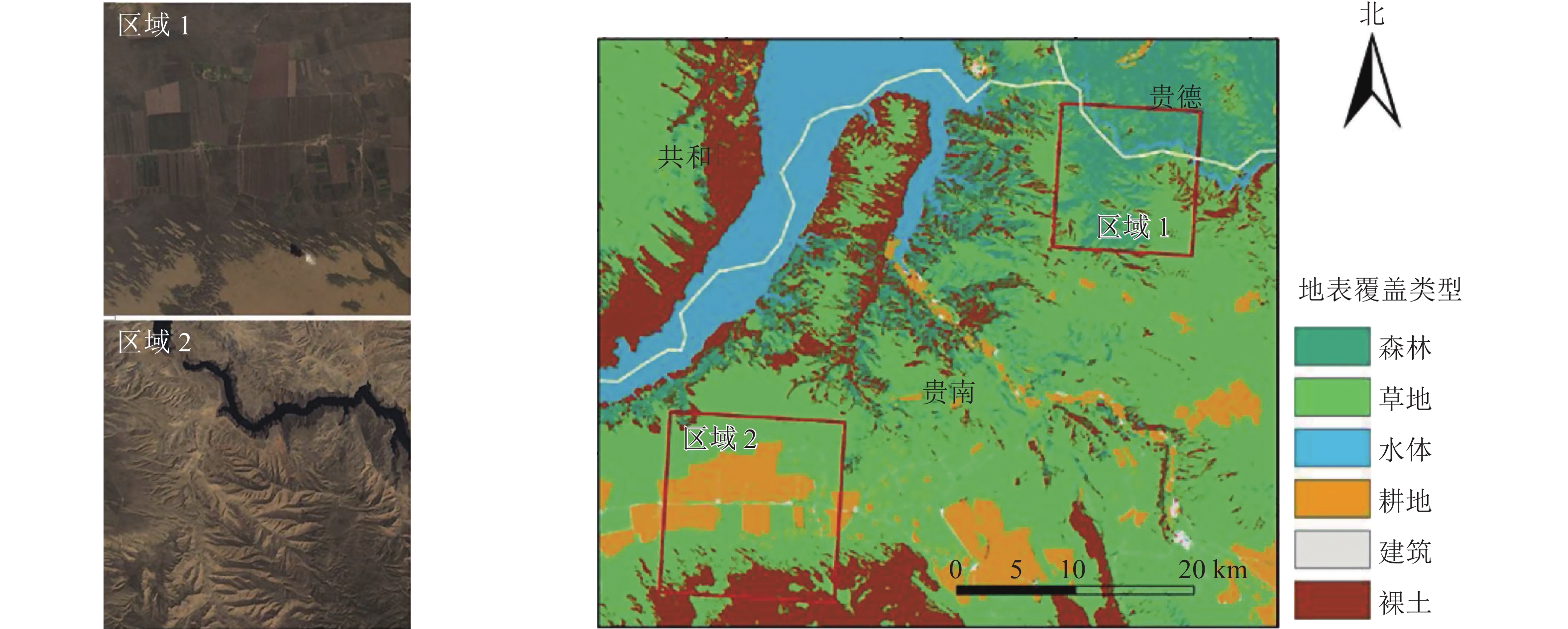
    • 研究区域位于三江源的东北部,青海省贵南县北部地区(35°41′12′′~36°09′20′′N,100°31′52′′~101°12′39′′E)。在研究区内选取了2块具有不同地形特征的区域(图1)。区域1 (15 km × 15 km)位于研究区的西南角,主要地表覆盖类型为农业用地,其次是草地,在南部有部分的沙地;该区域地势较为平整,地表覆盖状况较为复杂,空间纹理特征丰富,且地物边界特征清晰明显。区域2 (12 km × 12 km)位于研究区的东北部,主要地表覆盖类型为森林,其次为草地;地表起伏较大(最大海拔高差达945 m),北部有河流经过。所选择的2个区域地形地势特征及其地表覆盖都不相同,但都是在三江源区域非常具有代表性的地貌和植被类型。本研究采用的土地覆盖数据为ChinaCover[32],空间分辨率为30 m。

      Figure 1.  Location, land cover and Landsat-8 panchromatic images of the study area

      收集了研究区域2013年植被生长季内少云遮挡的高质量Landsat-8 OIL影像共3景,获取日期分别为6月12日(第163天)、6月28日(第179天)和10月2日(第275天)。在ENVI 5.1软件中对影像进行了辐射定标、大气纠正后,通过波段运算(近红外波段841~874 nm、红波段620~670 nm),得到30 m分辨率的Landsat NDVI数据。

      MODIS NDVI数据来自美国地质调查局(https://lpdacc.usgs.gov)发布的MOD13Q1产品,16 d最大合成NDVI,空间分辨率为250 m。经过MODIS 数据重投影工具(MODIS Reprojection Tools,MRT)进行转投影和格式转换,同时将HDF文件格式转为TIF影像。MODIS NDVI数据获取日期分别为5月9日(第129天)、5月25日(第145天)、6月10日(第161天)、6月26日(第177天)、7月12日(第193天)、7月28日(第209天)、8月13日(第225天)、8月29日(第241天)、9月14日(第257天)、9月30日(第273天)。

    • 比对3种基于权重的融合模型,包括STARFM[17]、ESTARFM[33]和Fit-FC[26]以及一种基于学习的融合模型RPRTM[34]在NDVI时空融合中的应用效果。基于30 m的Landsat影像和16 d步长的250 m MODIS NDVI数据,采用4种不同的时空融合模型生成30 m、16 d步长的NDVI数据。然后,根据融合后的NDVI数据的空间细节特征表达能力和时间动态监测效果,对4种不同融合模型进行评估。

      以真实的Landsat NDVI影像作为参考,定性的目视判读和定量的统计分析来评价不同模型结果的空间融合效果[35]。目视判别可以通过查看融合后数据的空间细节特征,给出融合结果优劣的定性评价。而统计分析则可以通过计算站点尺度真实影像与融合结果间的决定系数(R2),平均绝对误差(MAD),以及均方根误差(RMSE)定量评价融合模型的效果。其中R2越接近于1则表示模型的拟合效果越好,MAD、RMSE的数值越低,表明回归模型精度越高。采用标准差(Std)、平均梯度(AG)和信息熵(IE)等3个特征指标对融合影像进行定量分析[36]。以真实的MODIS NDVI时间动态为参考,分析不同融合方法对地表植被动态特征的拟合效果。依据时间距离最短原则选择模型输入数据,采用4种时空融合模型分别生成了2个研究区域内的NDVI时间序列数据。再分别统计了3种不同植被类型(草地、耕地和森林)在MODIS以及4种不同时空融合模型生成的NDVI时间序列内的时间动态,通过相关分析比较不同融合模型结果与MODIS NDVI动态特征的相似性。

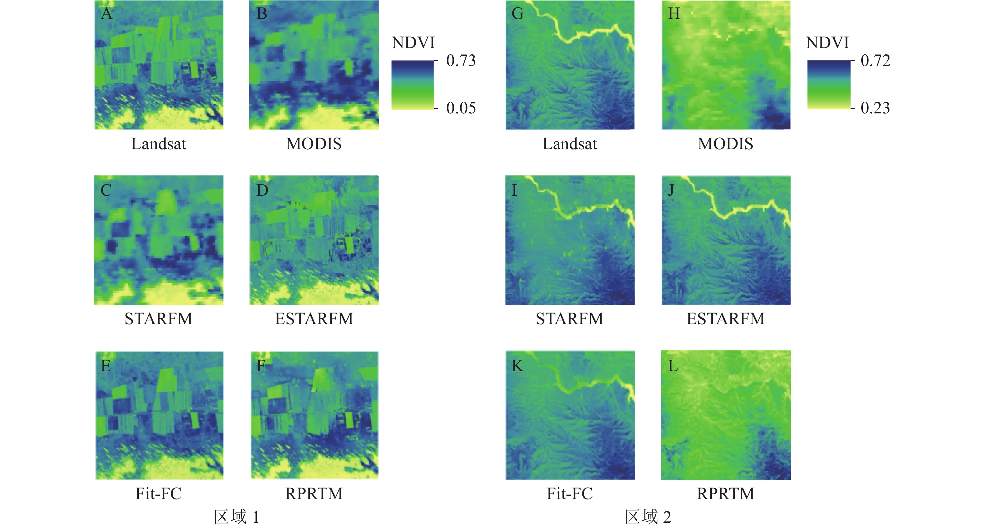
    • 图2为以6月28日为目标时刻,STARFM、ESTARFM和Fit-FC和RPRTM生成的NDVI结果,以及对应的MODIS NDVI真值(6月26日)、Landsat NDVI真值(6月28日)。通过目视解译分析,在2个不同区域,这4种融合模型结果均能在一定程度上显示较高分辨率的空间分布特征。从区域1的Landsat NDVI真实影像(图2A)可以看出:该区域具有较为丰富的纹理特征,地块之间边界清晰,与MODIS NDVI影像( 图2B)空间格局基本一致。STARFM融合结果(图2C)中斑块化问题较明显,耕地边界出现锯齿状模糊不清,ESTARFM (图2D)和Fit-FC (图2E)的融合结果要明显优于STARFM,可以清晰看出耕地、草地和沙地等不同地物的空间分布,与Landsat真实影像相似度很高。该区域RPRTM融合结果纹理特征更为清晰(图2F),可以清楚地看出不同耕地区域的边界,与Landsat NDVI真实影像一致性高,融合结果较好。

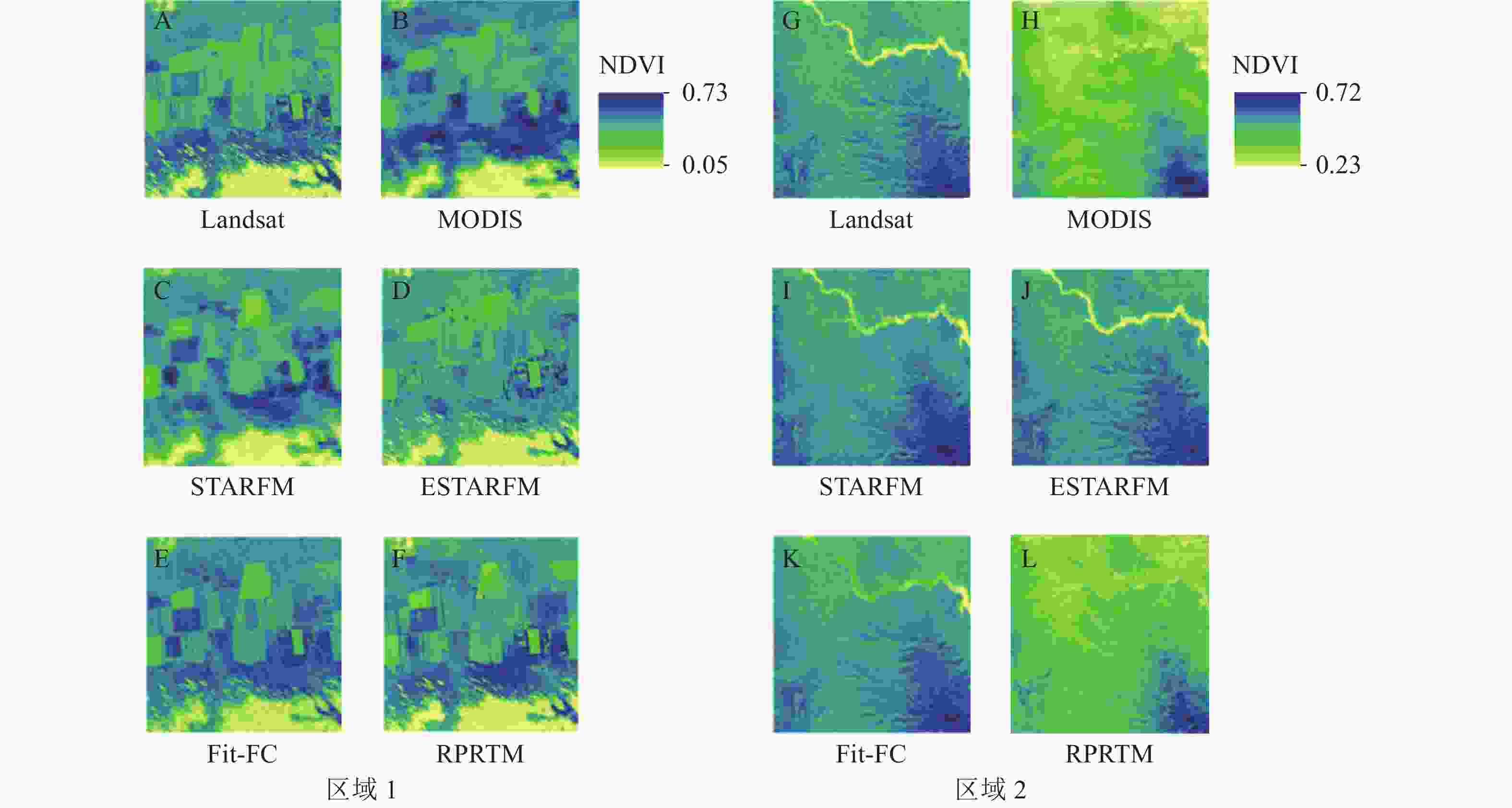
      Figure 2.  Outputs of different models and real NDVI images

      从区域2的Landsat NDVI真实影像中可以看到明显的地形起伏特征,以及清晰的河流边界(图2G)。MODIS NDVI影像的空间格局与Landsat基本一致,但森林区域的NDVI像元值略微偏低(图2H)。STARFM融合结果与Landsat NDVI影像的地形起伏格局基本一致,但是河流边界出现了若干的斑块问题(图2I)。ESTARFM融合结果具有清晰的地形变化特征,更接近Landsat NDVI真实影像,河流边界清晰可见(图2J)。Fit-FC融合结果(图2K)与Landsat真值影像相似,且与ESTARFM相近。RPTRM融合结果同样地形细节特征清晰,河流边界明显(图2L)。但与ESTARFM不同,RPRTM是以MODIS像元值为目标通过站点训练构建的融合模型,因而其融合结果像元值更接近于MODIS像元值,略低于Landsat影像的NDVI值。

    • 表1图3可以看出:在区域1中,RPRTM与Landsat NDVI真值的R2最高(0.82),MAD (0.04)和RMSE (0.04)相对较小,表明在该模型下预测图像所含信息丰富,效果最佳。其次为Fit-FC,与Landsat NDVI真值的R2为0.76,MAD、RMSE、Std、AG、IE分别为0.03、0.05、0.09、0.01、6.07;区域2的情况有所不同,ESTARFM与Landsat NDVI真值的R2最高,为0.95,MAD和RMSE最小,均为0.02,表明在该区域ESTARFM的融合结果与Landsat真实影像的相似度最高。造成这种差异的原因主要是相对于区域1,区域2模型输入数据(Landsat和MODIS)差异较大。STARFM、ESTARFM和Fit-FC同属于基于重构的多源遥感数据时空融合方法,根据光谱线性混合原理,通过2期MODIS影像的差异来模拟目标日期的Landsat,其融合结果与Landsat真值更为接近。而RPRTM则属于基于学习的多源遥感数据时空融合模型,以MODIS NDVI为目标变量进行模型训练,融合后结果与MODIS真值更为接近。所以当目标日期的Landsat影像与MODIS值差异较大时,RPRTM融合结果与Landsat影像的相似度相对较低。Fit-FC在区域1和区域2中与Landsat真实影像均有较高相似度,R2分别为0.76、0.90,表明该模型对多种地表覆盖状况的多源遥感数据融合有较好的适用性。

      区域融合模型R2MADRMSEStdAGIE
      区域1 Landsat 0.01 6.31
      MODIS 0.02 6.33
      STARFM 0.60 0.04 0.07 0.10 0.01 6.17
      ESTARFM 0.66 0.04 0.06 0.09 0.01 6.08
      Fit-FC 0.76 0.03 0.05 0.09 0.01 6.07
      RPRTM 0.82 0.04 0.04 0.10 0.02 6.34
      区域2 Landsat 0.02 6.13
      MODIS 0.01 5.97
      STARFM 0.88 0.02 0.07 0.09 0.01 5.92
      ESTARFM 0.95 0.02 0.02 0.10 0.02 6.13
      Fit-FC 0.90 0.17 0.18 0.15 0.03 6.92
      RPRTM 0.62 0.03 0.06 0.07 0.02 6.02

      Table 1.  Comparison of different model result

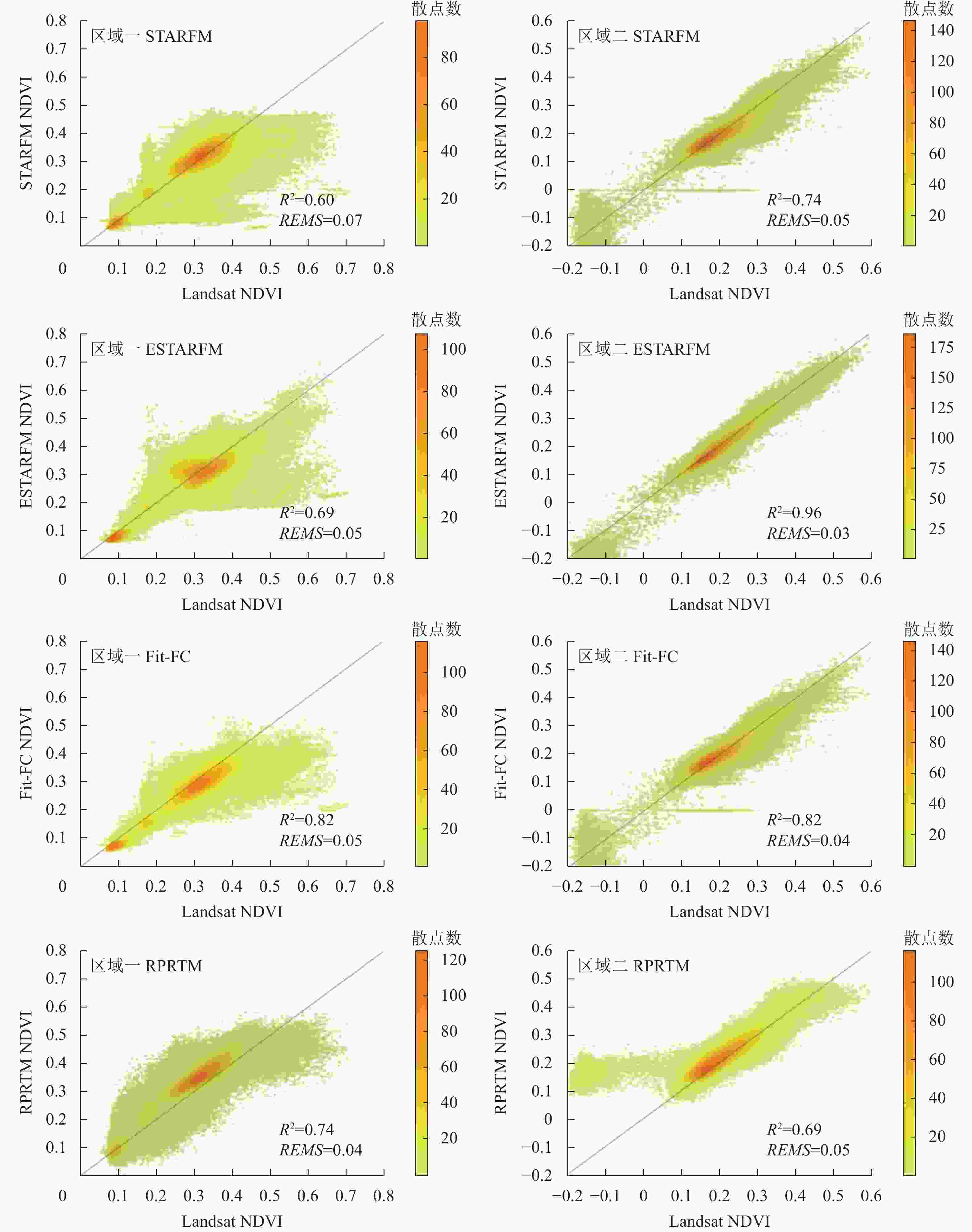
      Figure 3.  Scatter diagram between the fusion image and the real Landsat NDVI

    • 图4包括了MODIS和Landsat的NDVI观测数据以及4种模型融合数据的NDVI时序统计结果,时间分辨率为16 d,从2013年的第129天(5月9日)到第273天(9月30日)。总体来看,对于3种不同植被类型,4种融合方法均能较好地模拟其季节动态特征,能准确反映不同植被的生长动态变化。融合后的NDVI时间序列波动趋势与MODIS NDVI基本一致,在生长季内呈明显的单峰特征。其中RPRTM融合后NDVI曲线与MODIS真值吻合度最高,几乎重叠,其次为Fit-FC、ESTARFM,最后为STARFM,表明RPRTM融合后的NDVI时间序列最接近MODIS真实值。通过相关性分析同样可以看出:对于3种不同地表植被,RPRTM融合结果均取得了与MODIS NDVI最高的相关性,在草地(R2=0.99)、耕地(R2=0.99)和森林(R2=0.97)区域,对于地表植被状况的季节动态捕捉与MODIS真实值保持着高度的一致性。

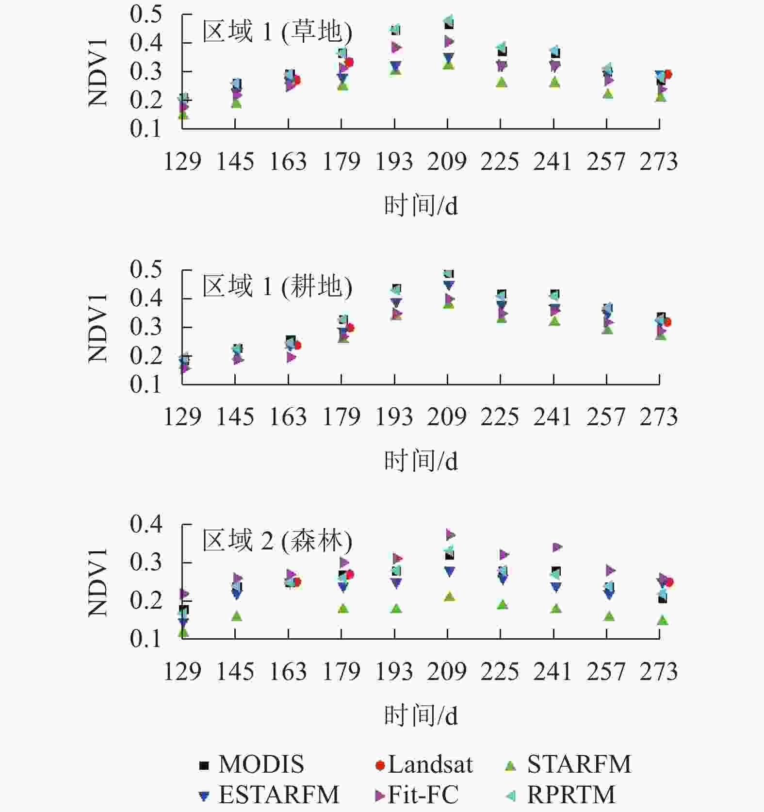
      Figure 4.  Comparison of results of different fusion models

    • STARFM、ESTARFM、Fit-FC和RPRTM都是针对单一传感器,不能同时满足对高时空分辨率数据的需要所提出的多源遥感数据时空融合模型,通过联合MODIS系列数据的时间变化信息和Landsat影像的空间分布特征,生成具有高时空分辨率的数据。ZHANG等[37]基于STARFM融合的NDVI数据不仅能获得更好的地上生物量(AGB)估算精度,同时还能获取更详细的草地AGB时空变化信息,有助于草地状况的监测以及灾害评估。然而,本研究中2个研究区域的STARFM融合效果较ESTARFM和RPRTM都要弱。有研究表明:STARFM模型应用的最大问题即当实际条件不满足忽略空间定位误差和大气纠正误差的前提下时,融合结果的精度将受到限制[22]。ESTARFM是针对STARFM在地表空间异质性较高区域融合效果较差的问题所提出的改进方法,假设像元反射率随时间变化稳定且为线性变化,此假设使得在估算长时间数据时产生较大的误差,在一定程度上限制了其在反射率非线性变化的植被地区的应用。ZHOU等[25]比较了6种典型的时空融合模型,认为Fit-FC模型最适用于NDVI影像融合,且具有较好的抗几何误差能力,但对系统性辐射误差很敏感。因此,如果2个传感器之间存在明显的辐射不一致,Fit-FC的表现将会很差。在本研究中,Fit-FC不仅在空间维度上能获得较好的NDVI融合结果,融合影像纹理特征清晰,在时间维度上Fit-FC融合结果也能较好地捕捉生长季NDVI的动态变化特征。不同于前三者基于重建的融合模型,RPRTM是属于基于学习的多源遥感数据融合方法,通过学习训练在MODIS与Landsat间构建经验模型,再通过训练后的模型,基于Landsat影像实现MODIS的降尺度,但同样存在一定局限性。首先,模型精度很大程度上依赖于所选择的训练样本,导致模型稳定性较弱。其次,以低空间分辨率、高时间分辨率影像为模型训练的目标变量,导致Landsat影像中的一些极端像元值难以在融合后的影像中体现[38]

      本研究2个不同的区域同时考察了地表覆盖特征以及模型输入数据差异对于融合效果的影响。区域1地表覆盖状况较为复杂,纹理更丰富,具有更高的空间异质性,模型输入数据一致性较高。区域2地表覆盖状况相对简单,但模型输入数据差异较大。SATRFM和ESATRFM在区域2融合结果与Landsat真实值的相似性要高于区域1,而在地表空间异质性较高的区域融合效果相对较差,可以认为相对于模型输入数据的时空可比性,地表异质性对STARFM和ESTARFM融合效果的影响更大。基于学习的RPRTM的NDVI融合结果在区域1比区域2与Landsat真值的相似性要高,其原因在于RPRTM是以MODIS像元值为真值进行模型训练,融合后结果与MODIS真值更为接近。所以当目标日期的Landsat影像与MODIS值差异较大时,RPRTM融合结果与Landsat影像的相似度相对较低,模型输入数据差异对RPRTM影像较大。

    • 4种融合方法中,地表覆盖状况对STARFM融合效果有较大的影响,在地表覆盖状况较为复杂的区域1,STARFM表现出较差的适用性(R2=0.60)。ESTARFM和Fit-FC在NDVI影像融合中的效果明显优于STARFM,可以有效地捕捉地表空间细节特征,更适用于复杂地表状况下的NDVI数据融合。从植被动态特征融合效果来看,4种融合模型对于3种不同植被类型均取得了较好的效果,其中RPRTM融合结果与MODIS NDVI的时间动态变化趋势最为一致。

Reference (38)

Catalog

    /

    DownLoad:  Full-Size Img  PowerPoint
    Return
    Return